
Browse All By Letter
Browse By Lists
Narrow Search
what
where
who
when

A boxing match, in Hapaee. J. Webber del. I. Taylor sc. (London, G. Nicol and T. Cadell, 1785)
who: Webber, John, 1751-1793; Cook, James, 1728-1779; G. Nicol and T. Cadell; Taylor, I., engraver; King, James
what: Exploration Book; View
when: 1785
where: Tonga; Ha'apai Group (Tonga)

(A branch of the bread-fruit tree with the fruit). J. Miller fecit. No. 11. London: printed for W. Strahan; and T. Cadell in the Strand, MDCCLXXIII).
who: Hawkesworth, John, 1715?-1773; Cook, James, 1728-1779; W. Strahan and T. Cadell; Miller, J.; Banks, Joseph, Sir, 1743-1820; Byron, John, 1723-1786
what: Exploration Book; View
when: 1773
where: Matavai Bay (Tahiti)

A cactus grove, Arizona, species Cereus giganteus, 1871. U.S. Geographical Survey West of the 100th Meridian. H.J. Morgan del. T. Sinclair & Son lith., Phila. (1878)
who: Morgan, H. J.; (Wheeler, G.M.); U.S.; T. Sinclair & Son; Wheeler, G.M.
what: Vegetation; Exploration Book; View
when: 1878
where: Arizona

A canoe of the Sandwich Islands, the rowers masked. J. Webber del. C. Grignion sc. (London, G. Nicol and T. Cadell, 1785)
who: Webber, John, 1751-1793; Cook, James, 1728-1779; G. Nicol and T. Cadell; Grignion, C.; King, James
what: Exploration Book; View
when: 1785
where: Hawaii; Kealakekua Bay (Hawaii)

A canon within a canon, in basin of the Colorado River. (1875)
who: (Wheeler, G.M.); U.S.; Wheeler, G.M.
what: Physical; Exploration Book; View
when: 1875
where: Arizona; Colorado River (Colo.-Mexico)

A Celestial Planisphere, or Map of the Heavens. (Pl. VIII.) Engraved by W.G. Evans under the Direction of E.H. Burritt. Hartford, Published by F.J. Huntington 1835. Entered according to act of Congress Septr. 1st 1835, by F.J. Huntington, of the State of Connecticut.
who: Burritt, Elijah H.; Huntington and Savage; Evans, W.G.
what: Celestial; Celestial Atlas; Atlas Map
when: 1835
where: Heavens

A chart and views of Pitcairns Island ... Bayly sculp. 1st. Jany., 1773. (London: printed for W. Strahan; and T. Cadell in the Strand, MDCCLXXIII).
who: Hawkesworth, John, 1715?-1773; Carteret, Philip, d. 1796; W. Strahan and T. Cadell; Bayly, John Abraham, fl. 1755-1794; Cook, James, 1728-1779; Banks, Joseph, Sir, 1743-1820; Byron, John, 1723-1786
what: Exploration Book; Chart Map; View
when: 1773
where: Pitcairn Island

A chart exhibiting the comparative size, population, form of government and number of square miles in each of the principal empires, kingdoms &c. of the globe, also the manner of building among the different nations according to their civilization. To accompany Olney's Geography. Entered according to act of Congress.
who: (Olney, J. (Jesse), 1798-1872); Robinson, Pratt & Co.; Olney, J. (Jesse), 1798-1872
what: School; School Atlas; Statistical Diagram; View
when: 1837
where: World

A chart of Captn. Carteret's discoveries at New Britain, with part of Captn. Cooke's passage thro Endeavor Streights, & of Captn. Dampier's tract & discoveries in 1699, & 1700, at New Guinea and New Britain. Engraved by W. Whitchurch, Pleasant Row, Islington. (London: printed for W. Strahan; and T. Cadell in the Strand, MDCCLXXIII).
who: Hawkesworth, John, 1715?-1773; Carteret, Philip, d. 1796; W. Strahan and T. Cadell; Cook, James, 1728-1779; Banks, Joseph, Sir, 1743-1820; Byron, John, 1723-1786
what: Exploration Book; Chart Map; Book Map
when: 1773
where: Indonesia; Papua New Guinea; New Guinea; New Britain Island (Papua New Guinea)

A chart of Hawkins's Maidenland, discovered by Sr. Richard Hawkins in 1574 and Falkland Sound, so called by Capn. John Strong of the Farewell from London who sailed through it in 1689. Isa: Noual sculp. No. 23. [London: printed for W. Strahan; and T. Cadell in the Strand, MDCCLXXIII).
who: Hawkesworth, John, 1715?-1773; Byron, John, 1723-1786; W. Strahan and T. Cadell; Noual, Isaac; Cook, James, 1728-1779; Banks, Joseph, Sir, 1743-1820
what: Exploration Book; Chart Map; Book Map
when: 1773
where: Falkland Islands

A chart of New South Wales, on the east coast of New-Holland. Discovered and explored by Lieutenant J: Cook, Commander of his Majesty's Bark Endeavour, in the year MDCCLXX. Engraved by W. Whitchurch, Bartholomew Lane, Royal Exchange. (London: printed for W. Strahan; and T. Cadell in the Strand, MDCCLXXIII).
who: Hawkesworth, John, 1715?-1773; Cook, James, 1728-1779; W. Strahan and T. Cadell; Whitchurch, William; Banks, Joseph, Sir, 1743-1820; Byron, John, 1723-1786
what: Exploration Book; Chart Map; Book Map
when: 1773
where: Australia; New South Wales; Queensland

A chart of New South Wales, Van Diemen's Land. Surveys in the interior of New South Wales. (with) Van Diemen's Land, from the most recent authorities and surveys. (with) Part of Australasia. (with) British settlements at Port Jackson, &c. J. Aspin, del. Hewitt sculp., Buckingham Place. (Drawn & engraved for Thomson's New general atlas, 1821)
who: Thomson, John; John Thomson; Baldwin, Cradock, and Joy; John Cumming; Hewitt, N. R.; Aspin, Jehoshaphat, 18th/19th cent.
what: World Atlas; Atlas Map
when: 1821
where: Australia; New South Wales; Tasmania

A chart of North and South America including the Atlantic and Pacific Oceans, with the nearest coasts of Europe, Africa and Asia (by John Green]. Publish'd according to Act of Parliament Feb. 19, 1753, by T. Jefferys, Geographer to his Royal Highness the Prince of Wales at the Corner of St. Martins Lane Charing Cross ...〈a>
who: Green, John, d d. 1757; Jefferys, Thomas; Thomas Jefferys; Green, John, d. 1757
what: Chart Map; Case Map
when: 1753
where: Western Hemisphere

A Chart of North and South America, including the Atlantic and Pacific Oceans, with the nearest Coasts of Europe, Africa, and Asia. Chart containing part of the Icy Sea with the adjacent Coast of Asia and America. Chart comprizing Greenland with the Countries and Islands about Baffins Bay and part of Hudsons Bay. Publish'd ... 10 June 1775, by Robt. Sayer & J. Bennett ... Fleet Street. No. II.
who: Jefferys, Thomas; Sayer and Bennett
what: National Atlas; Atlas Map
when: 1776
where: Arctic

A chart of part of ye sea coast of England, Holland & Flanders &c. Shewing the sands, banks, depth of water, bearing, and the course of the principal tracts from the River Thames, and Harwich, &c. to ye Texel, Helevoet Sluys, Ostend, Calais, and their distances in English miles, with remarks. By Herman Moll Geographer, according to Capt. G. Collins. (Printed and sold by T. Bowles next ye Chapter House in St. Pauls Churchyard, & I. Bowles at ye Black Horse in Cornhill. 1736?) 〈a>
who: Moll, Herman, d. 1732; Collins, Greenvile; Thos. Bowles and John Bowles
what: Shipping; World Atlas; Atlas Map; Chart Map
when: 1736
where: England; Netherlands; North Sea

A chart of the Antilles, or Charibbee, or Caribs Islands, with the Virgin Isles, by L.S. de la Rochette, MDCCLXXXIV. London: published by Wm. Faden, Geographer to the King, Charing-Cross, March 1st, 1784. W. Palmer, sculp.
who: Delarochette, L.; Faden, William; William Faden
what: World Atlas; Atlas Map; Chart Map
when: 1784
where: West Indies

A Chart Of The Banks Of Newfoundland, Drawn from a Great Number of Hydrographical Surveys, Chiefly from those of Chabert, Cook And Fleurieu, Connected and Ascertained by Astronomical Observations. London. Printed for & Sold by Robt. Sayer & Jno. Bennett ... 25th March 1776.
who: Jefferys, Thomas; Sayer and Bennett; Chabert, Cook and Fleurieu
what: National Atlas; Atlas Map
when: 1776
where: Newfoundland; Banks of Newfoundland

A chart of the British Channel and the Bay of Biscay, with a part of the North Sea, and the entrance of St. George's Channel. By Monsr. L. Abbe Diquemare (i.e. Dicquemare), with several emendations, and many useful additions &c. by L.S. De la Rochette. 3d. edition, MDCCXCIV. London, engraved & published as the Act directs by W. Faden, succr. to the late T. Jefferys, Geogr. to the King. Charing Cross, Sept. 17th, 1794.
who: Dicquemare, Abbe (Jacques Francois), 1733-1789; Delarochette, L.; Faden, William; William Faden
what: World Atlas; Chart Map
when: 1794
where: Europe; England; France; English Channel; Biscay, Bay of (France and Spain)

A chart of the British Channel; comprehending the southern coasts of England and Wales: from the mouth of the Thames to St. David's Head, with the coast of France from Dunkirk to the River of Nantes. By Thomas Jeffery's, Geographer to the King. London, published by Robert Sayer, no. 53 in Fleet Street, as the Act directs 20 Feby. 1787.
who: Jefferys, Thomas; Sayer and Bennett.
what: Regional Atlas; Atlas Map; Chart Map
when: 1787
where: England; France; English Channel

A Chart of the Chesapeake And Delaware Bays Compiled And Published By Fielding Lucas Junr. Baltimore Corrected_1840. Engraved by John and William Warr Philadelphia. Entered ... 1832 by Fielding Lucas Jr. ... Maryland.
who: Lucas, Fielding Jr.; Fielding Lucas Jr.; Warr, John, b. ca. 1798; Warr, William W.
what: Chart Map
when: 1840
where: Delaware; Chesapeake Bay; Delaware Bay

A chart of the coasts of Spain and Portugal, with the Balearic Islands, and part of the coast of Barbary. By L.S. De la Rochette. MDCCLXXX. 2d. edition. London: engraved & published as the Act directs, by Wm. Faden, successr. to the late T. Jefferys, Geogr. to the King. Charing Cross, June 28th, 1780.
who: Delarochette, L.; Faden, William; William Faden
what: World Atlas; Chart Map
when: 1780
where: Europe; Africa; Spain; Portugal; Mediterranean Sea

A chart of the discoveries of Captains Ross, Parry & Franklin in the Arctic Regions in the years 1818, 1819, 1820, 1821 & 1822. (with) Capt. Franklin's journey from Coppermine River to the head of Bathurst Inlet & return by Hood's River. J. Aspin delt. Hewitt sc., Buckingham Place. (Drawn & engraved for Thomson's New general atlas) (1822?)
who: Thomson, John; John Thomson; Baldwin, Cradock, and Joy; John Cumming; Hewitt, N. R.; Aspin, Jehoshaphat, 18th/19th cent.
what: World Atlas; Atlas Map
when: 1822
where: Arctic; Canada; Greenland

A Chart Of The Gulf Of St. Laurence, Composed From A Great Number Of Actual Surveys And Other Materials, Regulated and Connected by Astronomical Observations. London. Printed & Sold by Robt. Sayer & Jn. Bennett ... 25th March 1775.
who: Jefferys, Thomas; Sayer and Bennett
what: National Atlas; Atlas Map
when: 1776
where: Gulf of St. Lawrence

A Chart of the Internal Part of Louisiana, Including all the hitherto unexplored Countries, lying between the River La Platte of the Missouri on the N: and the Red River on the S: the Mississippi East and the Mountains of Mexico West; with a Part of New Mexico & the Province of Texas by Z.M. Pike Captn. U.S.I.
who: Pike, Zebulon Montgomery; C. & A. Conrad; Freeman, Thos.; Dunbar, Wm.; Wilkinson, Lieut.; Many, Capt.; Lewis, M.; Bradley
what: Exploration Book; Book Map
when: 1810
where: Mexico; Louisiana; New Mexico

A chart of the islands discover'd in the neighbourhood of Otaheite, in the course of several voyages round the world made by the cap(tai)ns Byron, Wallis, Carteret & Cooke in the years 1765, 1767, 1769. Whitchurch sculp., Pleasant Row, Islington. (London: printed for W. Strahan; and T. Cadell in the Strand, MDCCLXXIII).
who: Hawkesworth, John, 1715?-1773; W. Strahan and T. Cadell; Whitchurch, William; Cook, James, 1728-1779; Banks, Joseph, Sir, 1743-1820; Byron, John, 1723-1786
what: Exploration Book; Chart Atlas
when: 1773
where: Tuamotu Islands; Society Islands (French Polynesia)

A chart of the islands of Jersey and Guernsey, Sark, Herm and Alderney; with the adjacent coast of France. By L.S. De la Rochette. MDCCLXXXI. London: engraved & published as the Act directs Jany. 1st, 1781 by W. Faden, successor to the late T. Jefferys, Geogr. to the King, Charing Cross.
who: Delarochette, L.; Faden, William; William Faden
what: Shipping; World Atlas; Atlas Map; Chart Map
when: 1781
where: France; Channel Islands

A chart of the Maderas and Canary Islands, according to surveys published at Madrid in 1780, by Don Thomas Lopes, Geographer to His Catholick Majesty and ascertained by the astronomic observations of the Chevalier de Fleurieu, made by order of the French government in 1769. London, printed for Robt. Sayer, as the Act directs 1 Jany. 1787.
who: Jefferys, Thomas; Sayer and Bennett.
what: Regional Atlas; Atlas Map; Chart Map
when: 1787
where: Atlantic; Canary Islands; Madeira Islands

A Chart of the Sandwich Islands as Surveyed during the Visits of His Majesty's Sloop Discovery and Armed Tender Chatham Commanded by George Vancouver Esq. in the Years 1792, 1793 & 1794, and prepared under his immediate inspection by Lieut. Joseph Baker. Engraved by J. Warner. 15. (with) Part of the Gallapagos Isles (and) the Island of Cocoas. London: Published May 1st, 1798, by J. Edwards Pall Mall & G. Robinson Paternoster Row.
who: Vancouver, George, 1757-1798; G.G. & J. Robinson; Baker, Lieut. Joseph; Warner, J.
what: Chart Atlas; Atlas Map
when: 1798
where: Galapagos Islands; Hawaii

A chart of the southern extremity of America 1775. (with) Part of Staten Land. No. II. Published Febry. 1st, 1777 by Wm. Strahan in New Street, Shoe Lane & Thos. Cadell in the Strand, London.
who: Cook, James, 1728-1779; W. Strahan and T. Cadell
what: Exploration Book; Chart Map; Book Map
when: 1777
where: Chile; Argentina; Patagonia (Argentina and Chile); Tierra del Fuego (Argentina and Chile)
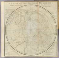
A chart of the Southern Hemisphere; shewing the tracks of some of the most distinguished navigators: by Captain James Cook of his Majesty's Navy. Gulielmus Whitchurch, sculpsit; Anno. 1776. Published Febry. 1st., 1777 by Wm. Strahan in New Street, Shoe Lane & Thos. Cadell in the Strand, London.
who: Cook, James, 1728-1779; W. Strahan and T. Cadell; Whitchurch, William
what: Exploration Book; Chart Map; Book Map
when: 1777
where: Southern Hemisphere

A Chart Of The Straits Of Magellan. Inlarged From The Chart Published At Madrid in 1769, by Don Juan de la Cruz Cano y Olmedilla of the Royal Academy of St. Fernando. and Improved from the Observations and Surveys of Captns. Byron, Wallis and Carteret compared with those of Monsr. De Bougainville. (with) A Chart of Magellania with Falkland's Islands. London. Printed for R. Sayer and J. Bennett ... 1st July 1775.
who: Jefferys, Thomas; Sayer and Bennett; Cano y Olmedilla, Don Juan de la Cruz; Byron, Capt.; Wallis, Capt.; Carteret, Capt.; Bougainville, Monsr. De
what: National Atlas; Atlas Map
when: 1776
where: Argentina; Chile; Magellan, Strait of (Chile and Argentina); Tierra del Fuego (Argentina and Chile); Patagonia (Argentina and Chile)

A Chart of the West Indies, From the latest Marine Journals and Surveys.
who: Carey, Mathew; Mathew Carey
what: World Atlas; Atlas Map
when: 1814
where: West Indies; Central America

A Chart of the West Indies, From the latest Marine Journals and Surveys. W. Barker sculp. Philada. Engraved for Carey's American Edition of Guthrie's Geography improved.
who: Carey, Mathew; Mathew Carey; Barker, William
what: National Atlas; Atlas Map
when: 1795
where: West Indies

A Chart of the West Indies, From the latest Marine Journals and Surveys. W. Barker sculp. Philada. Engraved for Carey's American Edition of Guthrie's Geography improved.
who: Carey, Mathew; Mathew Carey; Barker, William
what: World Atlas; Atlas Map
when: 1796
where: West Indies

A Chart of the West Indies, From the latest Marine Journals and Surveys. W. Barker, sculp. Philada. Engraved for Carey's American Edition of Guthrie's Geography improved.
who: Carey, Mathew; M. Carey; Barker, William
what: World Atlas; Atlas Map
when: 1811
where: West Indies

A Chart of the World According to Mercators Projection, Shewing the latest Discoveries of Capt. Cook.
who: Carey, Mathew; Mathew Carey
what: World Atlas; Atlas Map
when: 1814
where: World

A Chart of the World According to Mercators Projection. Shewing the latest Discoveries of Capt. Cook. William Barker sculp. Engrav'd for Carey's American Edition of Guthrie's Geography improved.
who: Carey, Mathew; Mathew Carey; Barker, William
what: World Atlas; Atlas Map
when: 1796
where: World

A chart of the World upon Mercator's projection. Describing the tracks of Capt. Cook in the year 1768, 69, 70, 71, and in 1772, 73, 74, 75, with the new discoveries. London, publish'd according to Act of Parliament by Jefferys & Faden, Corner of St. Martin's Lane, Charing Cross. 1775.
who: Faden, William, 1750?-1836; Jefferys, Thomas; William Faden
what: School; School Atlas; Atlas Map
when: 1775
where: World

A chart of the World upon Mercator's projection. London, published by Jefferys & Faden, Corner of St. Martin's Lane, Charing Cross. (1775?).
who: Faden, William, 1750?-1836; Jefferys, Thomas; William Faden
what: School; School Atlas; Atlas Map
when: 1775
where: World

A Chart of the World, According to Mercators Projection, Shewing the latest Discoveries of Capt. Cook. William Barker sculp. Engraved for Carey's American Edition of Guthrie's Geography improved.
who: Carey, Mathew; M. Carey; Barker, William
what: World Atlas; Atlas Map
when: 1811
where: World

A chart shewing part of the Coast of N.W. America, with the tracks of His Majesty's Sloop Discovery and armed tender Chatham, Commanded by George Vancouver Esq. and prepared under his immediate inspection by Lieut. Joseph Baker, in Which the Continental Shore has been finally traced and determined from Latd. 38¼15'N. and Longd. 237¼27'E. to Latd. 45¼46'N. and Longd. 236¼15'E. Engraved by B. Baker Islington. Plate 3. (with) Bay of Trinidad. London, published May 1, 1798 by J. Edwards Pall Mall, and G. Robinson Paternoster Row.
who: Vancouver, George, 1757-1798; G.G. & J. Robinson; Baker, B.; Baker, Lieut. Joseph
what: Chart Atlas; Chart Map
when: 1798
where: Trinidad (Calif.); California; Oregon

A Chart Shewing part of the Coast of N.W. America, With the Tracks of His Majesty's Sloop Discovery and Armed Tender Chatham; Commanded by George Vancouver Esqr. and prepared from the foregoing Surveys under his immediate inspection by Lieut. Edwd. Roberts in which the Continental Shore has been correctly Traced and Determined From Lat. 29¼54'N. and Long. 244¼33'E. to Cape Douglas in Lat. 58¼52'N and Longd. 207¼20'E. during the Summers of 1792, 1793, and 1794. 14. Warner Sculp. London: Published May 1st 1798, by J. Edwards Pall Mall & G. Robinson Paternoster Row.
who: Vancouver, George, 1757-1798; G.G. & J. Robinson; Roberts, Edwd. (Edward), Lieut.; Warner
what: Chart Atlas; Chart Map
when: 1798
where: North America; United States; Canada

A Chart shewing part of the Coast of N.W. America, With the Tracks of His Majesty's Sloop Discovery and Armed Tender Chatham; Commanded by George Vancouver Esqr. and prepared under his immediate inspection by Lieut. Joseph Baker, in which the Continental Shore has been traced and determined from Lat. 30¼00'N. and Long. 244¼32' E. to Lat. 38¼30'N and Long 237¼13'E. Engraved by T. Foot, Weston Place, Battle Bridge. No. 8. (with) Entrance of Port Sn. Francisco. (and) Port Sn. Diego. London: Published May 1st 1798, by J. Edwards Pall Mall & G. Robinson Paternoster Row.
who: Vancouver, George, 1757-1798; G.G. & J. Robinson; Baker, Lieut. Joseph; Foot, T.
what: Chart Atlas; Chart Map
when: 1798
where: Mexico; California; Baja California (Mexico : State); San Diego Bay (Calif.); San Francisco Bay (Calif.)

A Chart shewing part of the Coast of N.W. America, with the tracks of His Majesty's Sloop Discovery and Armed Tender Chatham; Commanded by George Vancouver Esqr. and prepared under his immediate inspection by Lieut. Joseph Baker, in which the Continental Shore has been traced and determined from Lat. 45¼30'N. and Long. 236¼12' E. to Lat. 52¼15'N and Long 232¼40'E. at the different periods shown by the Tracks. Warner Sculp. 5. (with) three inset maps. London: Published May 1st 1798, by J. Edwards Pall Mall & G. Robinson Paternoster Row.
who: Vancouver, George, 1757-1798; G.G. & J. Robinson; Warner; Baker, Lieut. Joseph
what: Chart Atlas; Chart Map
when: 1798
where: Oregon; Washington; British Columbia

A Chart shewing part of the Coast of N.W. America, with the tracks of His Majesty's Sloop Discovery and Armed Tender Chatham; Commanded by George Vancouver Esqr. and prepared under his immediate inspection by Lieut. Joseph Baker, in which the Continental Shore has been traced and determined from Lat. 51¼45'N. and Long. 232¼08' E. to Lat. 57¼30'N and Long 226¼44'E. at the different periods shown by the Tracks. Warner Sculp. 7. (with) A Survey of Port Stewart. London: Published May 1st 1798, by J. Edwards Pall Mall & G. Robinson Paternoster Row.
who: Vancouver, George, 1757-1798; G.G. & J. Robinson; Baker, Lieut. Joseph; Warner
what: Chart Atlas; Chart Map
when: 1798
where: Alaska; British Columbia

A Chart Shewing part of the Coast of N.W. America, With the Tracks of His Majesty's Sloop Discovery and Armed Tender Chatham; Commanded by George Vancouver Esqr. and prepared under his immediate inspection by Lieut. Joseph Baker, in which the Continental Shore has been traced and determined from Latd. 59¼45'N. and Longd. 219¼30'E. to Latd. 59¼56'N and Longd. 212¼08'E. at the periods shewn by the Track. No. 11. (with) A Survey of Port Chalmers. Engraved by T. Foot, Weston Place, St. Pancras. London. Published May 1st 1798, by J. Edwards, Pall Mall & G. Robinson, Paternoster Row.
who: Vancouver, George, 1757-1798; G.G. & J. Robinson; Baker, Lieut. Joseph; Foot, T.
what: Chart Atlas; Chart Map
when: 1798
where: Alaska

A Chart shewing part of the Coast of N.W. America, With the Tracks of His Majesty's Sloop Discovery and Armed Tender Chatham; Commanded by George Vancouver Esqr. and prepared under his immediate inspection by Lieut. Joseph Baker, in which the Continental Shore has been traced and determined from Latde. of 59¼30' North & Longde. 207¼20' East; to Cape Douglas in Latde. 58¼52' North and Longde. 207¼20' East. Engraved by S.J. Neele, 352 Strand. (with) A Survey of Port Chatham. London Published May 1st 1798, by T.R. Edwards Pall Mall & C. Robinson Paternoster Row.
who: Vancouver, George, 1757-1798; G.G. & J. Robinson; Baker, Lieut. Joseph; Neele, Samuel John, 1758-1824
what: Chart Atlas; Chart Map
when: 1798
where: Alaska

A Chart Shewing part of the Coast of N.W. America, With the Tracks of His Majesty's Sloop Discovery and Armed Tender Chatham; Commanded by George Vancouver Esqr. and prepared under his immediate inspection by Lieut. Joseph Baker, in which the Continental Shore has been traced and determined from Latde. 57¼07'1/2N. and Longd. 227¼00'E. to Latd. 59¼39'N and Longd. 219¼00'E. at the periods shewn by the Track. No. 12. (with) three inset maps. Engraved by T. Foot, Weston Place, St. Pancras. London: Published May 1st 1798, by J. Edwards Pall Mall & G. Robinson Paternoster Row.
who: Vancouver, George, 1757-1798; G.G. & J. Robinson; Baker, Lieut. Joseph; Foot, T.
what: Chart Atlas; Chart Map
when: 1798
where: Alaska

A Chart Shewing part of the S.W. Coast of New Holland With the Tracks of His Majesty's Sloop Discovery and Armed Tender Chatham Commanded by George Vancouver Esqr. in the Year 1791. Engraved by T. Foot. Weston Place, Battle Bridge. No. 1. (with) eight inset maps. London. Published May 1st 1798, by J. Edwards Pall Mall and G. Robinson Paternoster Row.
who: Vancouver, George, 1757-1798; G.G. & J. Robinson; Foot, T.
what: Chart Atlas; Chart Map
when: 1798
where: Pacific; New Zealand

(A chest of New Zealand, as a specimen of the carving of the country). No. 15. (London: printed for W. Strahan; and T. Cadell in the Strand, MDCCLXXIII).
who: Hawkesworth, John, 1715?-1773; Cook, James, 1728-1779; W. Strahan and T. Cadell; Banks, Joseph, Sir, 1743-1820; Byron, John, 1723-1786
what: Exploration Book; View
when: 1773
where: New Zealand
 Images copyright © 2000 by Cartography Associates.
Images may be reproduced or transmitted, but not for commercial use.
For commercial use or commercial republication, contact
.
This work is licensed under a Creative Commons License. By downloading any images from this site, you agree to the terms of that license.
Images copyright © 2000 by Cartography Associates.
Images may be reproduced or transmitted, but not for commercial use.
For commercial use or commercial republication, contact
.
This work is licensed under a Creative Commons License. By downloading any images from this site, you agree to the terms of that license.
home | about
| view the collection | recent
additions | news | help
Copyright© 2003 Cartography Associates.
All rights reserved.