|
Full Title
Tulare Public School, Tulare Co., Cal. (with) Office of Daily and Weekly Register, Pillsbury & Ellsworth props., Tulare, Cal. (with) Public fountain, presented to Tulare City by D.W. Madden. (1892)
List No
2211.004
Note
Sepia tone print. Illustration of school, grounds, human figures, carriage, horse and rider, bicycle, etc., with 2 ancillary illustration showing human figures, etc.
Author
G.W. & C.B. Colton & Co.
Full Title
(Covers to) Colton's driving & wheeling map of the country twenty five miles north of the city of New York. (with) New York City north of Central Park. G.W. & C.B. Colton & Co. 312 Broadway, New York. Entered ... 1892 by G.W. & C.B. Colton & Co. ... Washington.
List No
3163A
Note
The cover style and address of 312 Broadway is the same as the 1896 map of Staten Island. Printed outline color by township. The mustard cloth covers 16x9 are stamped with "Colton's Driving and Wheeling Map Of The Country Twenty-Five Miles North Of The City Of New York. G.W. & C.B. & Co. New York." in black; then repeated again below is "G.W. & C.B. & Co. New York".
Author
G.W. & C.B. Colton & Co.
Full Title
Colton's driving & wheeling map of the country twenty five miles north of the city of New York. (with) New York City north of Central Park. G.W. & C.B. Colton & Co. 312 Broadway, New York. Entered ... 1892 by G.W. & C.B. Colton & Co. ... Washington.
List No
3163.001
Note
Shows roads suitable for bicycles marked in red. A very late Colton map - the date of 1892 is the copyright date; the map may be of later date, but no other date is indicated. The cover style and address of 312 Broadway is the same as the 1896 map of Staten Island. Printed outline color by township. The mustard cloth covers 16x9 are stamped with "Colton's Driving and Wheeling Map Of The Country Twenty-Five Miles North Of The City Of New York. G.W. & C.B. & Co. New York." in black; then repeated again below is "G.W. & C.B. & Co. New York". The map shows several "Colored Sett." which notation we have never seen before. A note in red above the title says "These maps are particularly intended for the use of Sportsmen, Wheelmen, and Driving Parties, and we respectfully request that any errors or omissions which may be noticed, or other Suggestions for their improvement, shall be at once reported to us, that they may be incorporated into future editions. We especially desire names of creeks and ponds and information respecting new roads, etc." There is a catalogue of Colton road maps on the inside front cover. A blue rubber stamp at top right reads "Supplied by Rand McNally & Co."
Author
Servoss, R. D.
Full Title
(Covers to) Sectional road map of Westchester County, New York and part of Fairfield County, Conn. Indexed. Showing the good roads. Published by R.D. Servoss, 21 & 23 Centre St., New York. Copyright 1895, by R.D. Servoss.
List No
3889A
Note
Heavy lavender paper covers printed with "Price, 50 cents. Sectional road map of Westchester County, New York, with part of Fairfield County, Conn. ..."
Author
Servoss, R. D.
Full Title
(Title Page to) Sectional road map of Westchester County, New York and part of Fairfield County, Conn. Indexed. Showing the good roads. Published by R.D. Servoss, 21 & 23 Centre St., New York. Copyright 1895, by R.D. Servoss.
List No
3889B
Author
Servoss, R. D.
Full Title
Key map. Showing the area covered by each sectional map. (Sectional road map of Westchester County, New York ... ). Copyright 1895, by R.D. Servoss, N.Y.
List No
3889.001
Note
Col. index map to the 12 sectional maps.
Author
Servoss, R. D.
Full Title
Section 1. Showing the vicinity of New York City as far northward as High Bridge. Copyright 1894, by R.D. Servoss.
List No
3889.002
Note
Col. map. Relief shown by hachures. Shows good and fair roads, ferries, etc.
Author
Servoss, R. D.
Full Title
Section 2. Showing from Harlem northward to Yonkers, and eastward to Pelham Manor. Copyright 1895, by R.D. Servoss.
List No
3889.003
Note
Col. map. Relief shown by hachures. Shows good and fair roads, ferries, etc.
Author
Servoss, R. D.
Full Title
Section 3. Showing from Fort Schuyler northward to Orienta, and eastward to Glen Cove, L.I. Copyright 1894, by R.D. Servoss.
List No
3889.004
Note
Col. map. Relief shown by hachures. Shows good and fair roads, ferries, etc.
Author
Servoss, R. D.
Full Title
Section 4. Showing from Yonkers northward to Tarrytown, and eastward to Hartsdale. Copyright 1895, by R.D. Servoss.
List No
3889.005
Note
Col. map. Relief shown by hachures. Shows good and fair roads, ferries, etc. Covers also parts of Bergen and Rockland counties, N.J.
Author
Servoss, R. D.
Full Title
Section 5. Showing from Larchmont northward to Kensico Station, and from Hartsdale eastward to Greenwich, Conn. Copyright 1895, by R.D. Servoss.
List No
3889.006
Note
Col. map. Relief shown by hachures. Shows good and fair roads, ferries, etc.
Author
Servoss, R. D.
Full Title
Section 6. Showing from Long Id. Sound northward to Talmadge Hill, and from Cos Cob eastward to South Norwalk. Copyright 1895, by R.D. Servoss.
List No
3889.007
Note
Col. map. Relief shown by hachures. Shows good and fair roads, ferries, etc. Includes Bayport, Stamford, Glenbrook and Darien.
Author
Servoss, R. D.
Full Title
Section 7. Showing from Tarrytown northward to Oscawana, and eastward to Merritt's Corners. Copyright 1895, by R.D. Servoss.
List No
3889.008
Note
Col. map. Relief shown by hachures. Shows good and fair roads, ferries, etc.
Author
Servoss, R. D.
Full Title
Section 8. Showing from Kensico northward to Mount Kisco, and from Pleasantville eastward to Bedford. Copyright 1895, by R.D. Servoss.
List No
3889.009
Note
Col. map. Relief shown by hachures. Shows good and fair roads, ferries, etc.
Author
Servoss, R. D.
Full Title
Section 9. Showing from Darien, Conn. northward to Trinity Lake, and Stanwich, Conn. eastward to Wilton, Conn. Copyright 1895, by R.D. Servoss.
List No
3889.010
Note
Col. map. Relief shown by hachures. Shows good and fair roads, ferries, etc.
Author
Servoss, R. D.
Full Title
Section 10. Showing from Croton Landing northward to county line, and eastward to Yorktown. Copyright 1895, by R.D. Servoss.
List No
3889.011
Note
Col. map. Relief shown by hachures. Shows good and fair roads, ferries, etc. Includes also parts of Rockland and Orange counties, N.J. and Putnam County, N.Y.
Author
Servoss, R. D.
Full Title
Section 11. Showing from Mount Kisco northward to county line, and from Yorktown eastward to Cross River. Copyright 1895, by R.D. Servoss.
List No
3889.012
Note
Col. map. Relief shown by hachures. Shows good and fair roads, ferries, etc.
Author
Servoss, R. D.
Full Title
Section 12. Showing from Trinity Lake northward to Ridgebury, Conn., and from Cross River eastward to Bethel, Conn. Copyright 1895, by R.D. Servoss.
List No
3889.013
Note
Col. map. Relief shown by hachures. Shows good and fair roads, ferries, etc.
Author
Blum, George W.
Full Title
(Covers to) The Cyclers' Guide and Road Book of California Containing Map of California in relief with principal Roads, Seven Sectional Maps showing all available Roads for Cyclers from Chico to San Diego, and a Map of Golden Gate Park. 1896. Price, One Dollar. Compiled and Published by Geo. W. Blum, 330 Pine St., S.F. Edward Denny & Co., Agents. (on verso) Copyrighted 1895 By Geo. W. Blum, San Francisco, Cal.
List No
1592A
Author
Blum, George W.
Full Title
(Title Page to) The Cyclers' Guide and Road Book of California Containing Map of California in relief with principal Roads, Seven Sectional Maps showing all available Roads for Cyclers from Chico to San Diego, and a Map of Golden Gate Park. 1896. Price, One Dollar. Compiled and Published by Geo. W. Blum, 330 Pine St., S.F. Edward Denny & Co., Agents. (on verso) Copyrighted 1895 By Geo. W. Blum, San Francisco, Cal.
List No
1592B
Author
Blum, George W.
Full Title
(Text page to) The Cyclers' Guide and Road Book of California Containing Map of California in relief with principal Roads, Seven Sectional Maps showing all available Roads for Cyclers from Chico to San Diego, and a Map of Golden Gate Park. 1896. Price, One Dollar. Compiled and Published by Geo. W. Blum, 330 Pine St., S.F. Edward Denny & Co., Agents.
List No
1592C
Note
Includes explanation of symbols and abbreviations used on maps.
Author
Blum, George W.
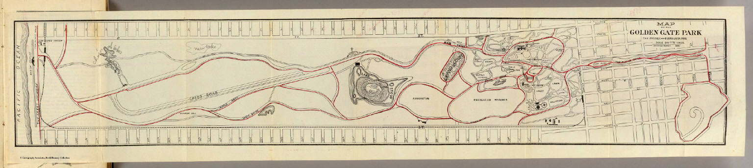
Full Title
Map of the Golden Gate Park, the Avenue and Buena Vista Park. 1895.
List No
1592.001
Note
Bike paths shown in red. The map has been updated in pencil, labeling "Chain of Lakes" and adding a new lake. A cross has also been added near Lake Stow.
Author
Blum, George W.
Full Title
Untitled map of Sonoma, Marin, Lake, and Napa Counties.
List No
1592.002
Note
Bike paths shown in red and labeled with abbreviations. The first abbreviation of the two tells the road condition. Conditions are: G (good), F (fair), P (poor), and V.P. (very poor). The second abbreviation is for the grade of the road. Grades include: L (level), R (rolling), H (hilly), and M (mountainous).
Author
Blum, George W.
Full Title
(Untitled map of the South Bay including San Mateo, Santa Cruz, Santa Clara, Alameda, and Contra Costa Counties.)
List No
1592.003
Note
Bike paths shown in red and labeled with abbreviations. The first abbreviation of the two tells the road condition. Conditions are: G (good), F (fair), P (poor), and V.P. (very poor). The second abbreviation is for the grade of the road. Grades include: L (level), R (rolling), H (hilly), and M (mountainous).
Author
Blum, George W.
Full Title
(Untitled map of the area around Sacramento and Marysville including Colusa, Yolo, Napa, Butte, Yuba, Sutter, Solano, and Sacramento Counties.)
List No
1592.004
Note
Bike paths shown in red and labeled with abbreviations. The first abbreviation of the two tells the road condition. Conditions are: G (good), F (fair), P (poor), and V.P. (very poor). The second abbreviation is for the grade of the road. Grades include: L (level), R (rolling), H (hilly), and M (mountainous).
Author
Blum, George W.
Full Title
(Untitled map of the Central Coast area including San Benito, Fresno, Monterey, San Luis Obispo, Kings, Kern, and Santa Barbara Counties.)
List No
1592.005
Note
Bike paths shown in red and labeled with abbreviations. The first abbreviation of the two tells the road condition. Conditions are: G (good), F (fair), P (poor), and V.P. (very poor). The second abbreviation is for the grade of the road. Grades include: L (level), R (rolling), H (hilly), and M (mountainous).
Author
Blum, George W.
Full Title
(Untitled map of the Central Valley area including Sacramento, Amador, Calaveras, San Joaquin, Tuolumne, Stanislaus, Merced, and Mariposa Counties.)
List No
1592.006
Note
Bike paths shown in red and labeled with abbreviations. The first abbreviation of the two tells the road condition. Conditions are: G (good), F (fair), P (poor), and V.P. (very poor). The second abbreviation is for the grade of the road. Grades include: L (level), R (rolling), H (hilly), and M (mountainous).
Author
Blum, George W.
Full Title
(Untitled map of Southern California including Ventura, Los Angeles, San Bernardino, Orange, and San Diego Counties.)
List No
1592.007
Note
Bike paths shown in red and labeled with abbreviations. The first abbreviation of the two tells the road condition. Conditions are: G (good), F (fair), P (poor), and V.P. (very poor). The second abbreviation is for the grade of the road. Grades include: L (level), R (rolling), H (hilly), and M (mountainous).
Author
Blum, George W.
Full Title
Map of California Roads for Cyclers. This Map Engraved by the California Photo-Eng. Co. Wasp B'ld'g., 513 Market St., S.F. Designed & Drawn by Geo. W. Blum. Edward Denny & Co. 207 Montgomery St. Sole Agents. Published and Copyrighted by Geo. W. Blum, San Francisco, Cal. (with) Inset map of the Los Angeles area.
List No
1592.008
Note
Full color map surrounded by advertisements. Bike paths shown in red and labeled with abbreviations. The first abbreviation of the two tells the road condition. Conditions are: G (good), F (fair), P (poor), and V.P. (very poor). The second abbreviation is for the grade of the road. Grades include: L (level), R (rolling), H (hilly), and M (mountainous).
Author
Rand McNally and Company
Full Title
(Covers to) Rand, McNally & Co.'s Cycling & Wagon Road Map Of South Eastern Wisconsin. Copyrighted By Rand, McNally & Co. (ink stamped) Copyrighted 1895, Rand, McNally & Co.
List No
4982.001
Note
A very detailed map in four sheets showing virtually all the roads, railroads, streams, lakes, and political information for Southeastern Wisconsin. The folding tan paper covers 16x9 have two advertisements for bicycles, and title on front reading "Rand, McNally & Co.'s Wagon Road Map Of Southeastern Wisconsin For Cyclists, Tourists, and Sportsmen. Shows Wagon Roads, Rivers, Sections, Creeks, Lakes, Etc. Rand, McNally & Co.: Map Publishers And Engravers, Chicago And New York." This is the only Rand McNally bicycle map that we have seen. Full hand coloring by county.
Author
Rand McNally and Company
Full Title
Rand, McNally & Co.'s Cycling & Wagon Road Map Of South Eastern Wisconsin. Copyrighted By Rand, McNally & Co. (ink stamped) Copyrighted 1895, Rand, McNally & Co.
List No
4982.002
Note
A very detailed map in four sheets showing virtually all the roads, railroads, streams, lakes, and political information for Southeastern Wisconsin. The folding tan paper covers 16x9 have two advertisements for bicycles, and title on front reading "Rand, McNally & Co.'s Wagon Road Map Of Southeastern Wisconsin For Cyclists, Tourists, and Sportsmen. Shows Wagon Roads, Rivers, Sections, Creeks, Lakes, Etc. Rand, McNally & Co.: Map Publishers And Engravers, Chicago And New York." This is the only Rand McNally bicycle map that we have seen. Full hand coloring by county.
Author
Watson, Walter
Full Title
Railway and highway map of the famous Berkshire Hills region, showing also villages and points of interest : from official records and other information, by Walter Watson, c.e. for the Berkshire Life Insurance Co. of Pittsfield, Mass., 1883. (Corrected 1896.) Copyright, 1883 by Walter Watson C.E. Sun Printing Co. Pittsfield, Mass.
List No
8016.000
Note
Detailed color map, surrounded with some text related to the local Berkshire Life Insurance Co., as well as discussion the Berkshires, as an encouragement and gesture toward tourists who could bicycle throughout the countryside. With two vignettes of the Office of Berkshire Life Insurance Co. and the Berkshire Hills. Map shows roads, railroads, drainage, terrain, and major cities. Relief shown by hachures and spot heights. Printed in red in lower right hand corner: "For copies of this map apply to the Berkshire Life Insurance Company of Pittsfield, Mass., or to any of its Agencies in the principal cities of the Northern and Eastern States".
Author
League of American Wheelmen, Wisconsin Division
Full Title
(Covers to) Bicycle Road Maps In Sections of the State of Wisconsin. Copyrighted and Published by the Wisconsin Division, League of American Wheelmen ... C.B. Case, L.A.W. Map Department. 411 Milwaukee St., Milwaukee, Wis. 1897.
List No
4067A
Author
League of American Wheelmen, Wisconsin Division
Full Title
(Index to) Bicycle Road Maps In Sections of the State of Wisconsin. Copyrighted and Published by the Wisconsin Division, League of American Wheelmen ... C.B. Case, L.A.W. Map Department. 411 Milwaukee St., Milwaukee, Wis. 1897.
List No
4067B
Author
League of American Wheelmen, Wisconsin Division
Full Title
Section 1. Bicycle Road Map of Wisconsin. Published by Wisconsin Division, League of American Wheelmen. (Dane, Jefferson, Waukesha, Milwaukee, Green, Rock, Walworth, Racine, and Kenosha counties). Copyright 1897 by M.C. Rotier.
List No
4067.001
Note
Map in blue. The legend shows type of road. The roads are rated by two different scales: Numbered - 1=Level, 2=Hilly, 3=Very Hilly; Lettered - A=Good, B=Medium, C=Bad.
Author
League of American Wheelmen, Wisconsin Division
Full Title
Section 2. Bicycle Road Map of Wisconsin. Published by Wisconsin Division, League of American Wheelmen. (Marquette, Green Lake, Fond du Lac, Sheboygan, Columbia, Dodge, Washington, Ozaukee, and Dane counties). Copyright 1897 by M.C. Rotier.
List No
4067.002
Note
Map in blue. The legend shows type of road. The roads are rated by two different scales: Numbered - 1=Level, 2=Hilly, 3=Very Hilly; Lettered - A=Good, B=Medium, C=Bad.
Author
League of American Wheelmen, Wisconsin Division
Full Title
Section 3. Bicycle Road Map of Wisconsin. Published by Wisconsin Division, League of American Wheelmen. (Outagamie, Brown, Kewaunee, Door, Winnebago, Calumet, and Manitowoc counties). Copyright 1897 by M.C. Rotier.
List No
4067.003
Note
Map in blue. The legend shows type of road. The roads are rated by two different scales: Numbered - 1=Level, 2=Hilly, 3=Very Hilly; Lettered - A=Good, B=Medium, C=Bad.
Author
League of American Wheelmen, Wisconsin Division
Full Title
Section 4. Bicycle Road Map of Wisconsin. Published by Wisconsin Division, League of American Wheelmen. (Grant, Iowa and Lafayette counties). Copyright 1897 by M.C. Rotier.
List No
4067.004
Note
Map in blue. The legend shows type of road. The roads are rated by two different scales: Numbered - 1=Level, 2=Hilly, 3=Very Hilly; Lettered - A=Good, B=Medium, C=Bad.
Author
League of American Wheelmen, Wisconsin Division
Full Title
Section 5. Bicycle Road Map of Wisconsin. Published by Wisconsin Division, League of American Wheelmen. (La Crosse, Monroe, Juneau, Adams, Vernon, Crawford, Richland, and Sauk counties). Copyright 1897 by M.C. Rotier.
List No
4067.005
Note
Map in blue. The legend shows type of road. The roads are rated by two different scales: Numbered - 1=Level, 2=Hilly, 3=Very Hilly; Lettered - A=Good, B=Medium, C=Bad.
Author
League of American Wheelmen, Wisconsin Division
Full Title
Section 6. Bicycle Road Map of Wisconsin. Published by Wisconsin Division, League of American Wheelmen. (Wood, Portage, Waupaca, Juneau, Adams, and Washara counties). Copyright 1897 by M.C. Rotier.
List No
4067.006
Note
Map in blue. The legend shows type of road. The roads are rated by two different scales: Numbered - 1=Level, 2=Hilly, 3=Very Hilly; Lettered - A=Good, B=Medium, C=Bad.
Author
League of American Wheelmen, Wisconsin Division
Full Title
Section 7. Bicycle Road Map of Wisconsin. Published by Wisconsin Division, League of American Wheelmen. (Pierce, Dunn, Eau Claire, Clark, Pepin, Buffalo, Trempealeau, and Jackson counties). Copyright 1897 by M.C. Rotier.
List No
4067.007
Note
Map in blue. The legend shows type of road. The roads are rated by two different scales: Numbered - 1=Level, 2=Hilly, 3=Very Hilly; Lettered - A=Good, B=Medium, C=Bad.
Author
League of American Wheelmen, Wisconsin Division
Full Title
Section 8. Bicycle Road Map of Wisconsin. Published by Wisconsin Division, League of American Wheelmen. (Langlade, Shawano, Oconto, and Marinette counties). Copyright 1897 by M.C. Rotier.
List No
4067.008
Note
Map in blue. The legend shows type of road. The roads are rated by two different scales: Numbered - 1=Level, 2=Hilly, 3=Very Hilly; Lettered - A=Good, B=Medium, C=Bad.
Author
League of American Wheelmen, Wisconsin Division
Full Title
Section 9. Bicycle Road Map of Wisconsin. Published by Wisconsin Division, League of American Wheelmen. (Price, Taylor, Lincoln, Clark, and Marathon counties). Copyright 1897 by M.C. Rotier.
List No
4067.009
Note
Map in blue. The legend shows type of road. The roads are rated by two different scales: Numbered - 1=Level, 2=Hilly, 3=Very Hilly; Lettered - A=Good, B=Medium, C=Bad.
Author
League of American Wheelmen, Wisconsin Division
Full Title
Section 10. Bicycle Road Map of Wisconsin. Published by Wisconsin Division, League of American Wheelmen. (Polk, Barron, St. Croix, Dunn, and Chippewa counties). Copyright 1897 by M.C. Rotier.
List No
4067.010
Note
Map in blue. The legend shows type of road. The roads are rated by two different scales: Numbered - 1=Level, 2=Hilly, 3=Very Hilly; Lettered - A=Good, B=Medium, C=Bad.
Author
League of American Wheelmen, Wisconsin Division
Full Title
Section 11. Bicycle Road Map of Wisconsin. Published by Wisconsin Division, League of American Wheelmen. (Vilas, Oneida, Forest, Florence, and Marinette counties). Copyright 1897 by M.C. Rotier.
List No
4067.011
Note
Map in blue. The legend shows type of road. The roads are rated by two different scales: Numbered - 1=Level, 2=Hilly, 3=Very Hilly; Lettered - A=Good, B=Medium, C=Bad.
Author
League of American Wheelmen, Wisconsin Division
Full Title
Section 12. Bicycle Road Map of Wisconsin. Published by Wisconsin Division, League of American Wheelmen. (Douglas, Bayfield, Ashland, Iron, Burnett, Washburn, Sawyer, and Price counties). Copyright 1897 by M.C. Rotier.
List No
4067.012
Note
Map in blue. The legend shows type of road. The roads are rated by two different scales: Numbered - 1=Level, 2=Hilly, 3=Very Hilly; Lettered - A=Good, B=Medium, C=Bad.
Author
Servoss, R. D.
Full Title
(Covers to) Servoss' sectional road map of Westchester County, New York with part of Fairfield County, Conn. Showing the good roads. Indexed. Published by Isaac H. Blanchard Co. 268-270 Canal St. New York. Copyright, 1902, by Isaac H. Blanchard Co.
List No
3890A
Note
Heavy white paper covers printed with "Price 50 cts. Servoss' sectional road map of Westchester County, New York, with part of Fairfield County, Conn. Showing the good roads with description of scenery, routes, etc. ..."
Author
Servoss, R. D.
Full Title
(Title Page to) Servoss' sectional road map of Westchester County, New York with part of Fairfield County, Conn. Showing the good roads. Indexed. Published by Isaac H. Blanchard Co. 268-270 Canal St. New York. Copyright, 1902, by Isaac H. Blanchard Co.
List No
3890B
Author
Servoss, R. D.
Full Title
Key map, showing the area covered by each sectional map (Servoss' sectional road map of Westchester County, New York with part of Fairfield County, Conn. 1902)
List No
3890.001
Note
Col. index map to the 12 sectional maps.
Author
Servoss, R. D.
Full Title
Section 1. Showing the vicinity of New York City as far northward as High Bridge. (1902)
List No
3890.002
Note
Relief shown by hachures. Shows good, fair and ordinary roads, etc.
|