Who What Where WhenWHATShow MoreWHEREShow More |
Author
[Mercator, Gerhard, 1512-1594, Hondius, Iodocus, 1563-1612]
Full Title
Peregrinatio Israelitaru in deserto. (to accompany) Atlas minor Gerardi Mercatoris.
List No
11201.469
Note
Map of Holy Land, depicting the Exodus and the wandering of the Children of Israel. Includes inset of the Encampment of Israel. Relief shown pictorially.
Author
[Mercator, Gerhard, 1512-1594, Hondius, Jodocus, 1563-1612, Saltonstall, Wye]
Full Title
The Holy Land. Peregrinatio Israelitaru in Deserto. (to accompany) Historia mundi : or Mercator's atlas. London Printed for Michaell Sparke, and are to be sowld in Greene Arboiure, 1637. Second edytion.
List No
11248.624
Note
Copper-engraving uncolored map of Holy Land, depicting the Exodus and the wandering of the Children of Israel. Includes inset of the Encampment of Israel. Relief shown pictorially.
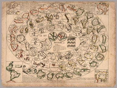
Author
Du Val, Pierre, 1619-1683
Full Title
Le Jeu du Monde dédié à Monsieur, Monsieur le Comte de Vivone, premier gentilhome de chambre du Roy par son très humble et très obéissant serviteur Duval. A Paris chez l'auteur P. Du Val d'Abbeville, avec Privilége du Roy, 1645, et se vendant rue S.t Jacques à l'Espérance
List No
6728.000
Note
This is one of the earliest geographical games that we have seen. Only one other copy is known of this game, held by the Bibliothèque nationale de France. The object of the game is to progress from the outer parts of the world in towards the center (France) by rolling dice and moving each player's piece from circle to circle on the board. California is shown as an island in circle 5. Duval also made a similar game of France. The rules to the game are shown here https://www.dhi.ac.uk/hartlib/view?docset=main&docname=8A_06
Author
Wells, Edward, 1667-1727
Full Title
A new map shewing the travels of the Patriarchs, as also of the children of Israel, from Egypt through the wildnerness, to the Land of Canaan. Sutton Nicholls sculp. (inset) This draught shews the several countries or people lying most remote from the Holy Land and mentioned in the Old Testament. (to accompany) A new sett of maps both of antient and present geography. 33.
List No
11181.036
Note
Copper engraved double page map of the Holy Land, with an inset map of the travels of the Patriarchs. Showing political divisions. Inset covers Mediterranean and the Near East, from Spain to Persia. Relief shown pictorially. Includes abbreviations.
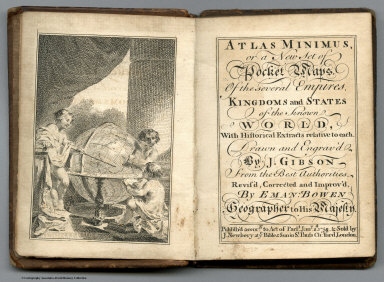
Author
[Bowen, Emanuel, Gibson, John]
Full Title
(Title Page to) Atlas Minimus or a New Set of Pocket Maps of the Several Empires, Kingdoms and States of the Known World, with Historical Extracts relative to each. Drawn and Engraved by J. Gibson from the Best Authorities, Revis'd, Corrected and Improv'd by Eman: Bowen Geographer to His Majesty.
List No
0300.002
Note
Title page facing a vignette showing three children studying the globe. First edition. The "Historical Extracts" are short bits of text printed on the maps giving relevant geographical information. A revised edition was published in London in 1792. In 1759, another edition was published adding separate geographical descriptions and correcting some of the maps (see our copy). The Philadelphia 1798 edition by Mathew Carey incorporates the 1759 edition text word for word (excepting the maps of United States which Carey omits in favor of his pocket atlas of the U.S.). Gibson and Bowen made the four sheet map of North America (Stevens 49), and Gibson made the four sheet map of America (Stevens 3).
Author
Spilsbury, John
Full Title
Europe divided into its kingdoms, etc. 1766. By J. Spilsbury.
List No
15760.000
Author
Akisato, Rito
Full Title
"In ancient times, people who were ordinary mortals with forty karmic debts, through their accumulated good deeds, received this realization. At this place, after practicing for three kalpas and a hundred aeons, they immediately save sentient beings."
List No
16149.039
Note
This image appears to depict a religious or ceremonial scene involving a Buddhist monk and a group of people. Here’s a breakdown of what might be happening: The Monk: A Buddhist monk stands on a platform, likely addressing or interacting with the people below. His posture suggests he may be offering a blessing, instruction, or religious guidance. His elevated position and traditional robes imply his role as a figure of authority. The People: The group of people in the image seems to be reaching out towards the monk. Some are raising their hands, possibly in prayer or as a gesture of receiving blessings. Others appear to be holding offerings or objects, perhaps as part of a religious ritual. The group is diverse, including men, women, and children, all in traditional Japanese attire. Setting: The setting includes elements of nature, such as a blossoming tree, suggesting the scene might be taking place during spring, possibly around the time of a religious festival. The structure the monk stands on seems to be part of a temple or sacred building, given the architectural style. Symbolism: The act of the people reaching towards the monk may symbolize devotion, spiritual yearning, or the receiving of teachings. The scene captures the relationship between the religious leader and the followers, typical in Buddhist contexts where monks play a key role in guiding laypeople in religious practices. In summary, this image likely represents a moment of Buddhist ritual or public sermon, where the monk provides guidance or blessings, and the people express devotion through gestures of reverence and offering. The natural elements and attire suggest it may be tied to a seasonal event or celebration.
Author
Lopez de Vargas Machuca, Tomas (1730-1802)
Full Title
Mapa del Reyno de Sevilla, dibidido en su Arzobispado, Obispado, y Tesorerías ... Por D. Thomas Lopez pensionista de S.M. ano de 1767
List No
15570.003
Note
Engraved outline hand colored map with title carthouche. Shows administrative divisions, major cities, towns, villages, landmarks, public buildings, roads, rivers, canals, forests and mountains. Relief shown pictorially and by hachures. Prime meridian is Tenerife. Includes explanation to symbols, descriptive text, and key to convents and monasteries.
Author
Lopez de Vargas Machuca, Tomas (1730-1802)
Full Title
Mapa geografico del Reyno de Cordoba : Comprehende los Partidos Jurisdicionales de Cordoba, el Carpio, los Pedroches y Santa Eufemia ... Por Don Tomas Lopez, Geografo de los dominios de S.M. Madrid ano de 1797
List No
15570.004
Note
Engraved outline hand colored map with title carthouche. Shows administrative divisions, major cities, towns, villages, landmarks, public buildings, roads, rivers, canals, forests and mountains. Relief shown pictorially and by hachures. Prime meridian is Tenerife. Includes explanation to symbols, descriptive text, and key to convents and monasteries.
Author
Lopez de Vargas Machuca, Tomas (1730-1802)
Full Title
Mapa geografico del Reyno de Granada : contiene los partidos de la Ciudad de Granada ... Por Don Tomas Lopez, Geografo de los dominios de S.M. ... Madrid ano de 1795.
List No
15570.006
Note
Engraved outline hand colored map with title carthouche. Shows administrative divisions, major cities, towns, villages, landmarks, public buildings, roads, rivers, canals, forests and mountains. Relief shown pictorially and by hachures. Prime meridian is Tenerife. Includes explanation to symbols, descriptive text, and key to convents and monasteries.
Author
Lopez de Vargas Machuca, Tomas (1730-1802)
Full Title
Mapa geografico del Reyno de Jaen, dividido en los Partidos de Jaen, Baeza, Ubeda, Andujar, Martos y las poblaciones de Sierra Morena ... Por Don Tomas Lopez, Geografo de los dominios de S.M. ... Madrid ano de 1787.
List No
15570.007
Note
Engraved outline hand colored map with title carthouche. Shows administrative divisions, major cities, towns, villages, landmarks, public buildings, roads, rivers, canals, forests and mountains. Relief shown pictorially and by hachures. Prime meridian is Tenerife. Includes explanation to symbols, descriptive text, and key to convents and monasteries.
Author
Lopez de Vargas Machuca, Tomas (1730-1802)
Full Title
(Covers to) Atlas geografico de Espana : que comprende el mapa general de la peninsula, todos los particulares de nuestras provincias, y el del reyno de Portugal. Por Don Tomas Lopez, geografo que fue de los dominios de S.M. e individuo de varias academias y sociedades. Tomo Primero. Ano 1810. Se hallara en Madrid, Calle de Atocha frente a la plazuela del Angel no. 1, y a la casa de los Gremios no. 3.
List No
11510.001
Note
Second edition of the geographic atlas of Spain, published in 1810, with half title page, 4 pages of index, contents and text. Comprising 38 maps on 98 sheets, Madrid (sheet 99) added later by owner, along with three other maps later removed. Some maps on multiple sheets. Maps dated 1765 - 1802. Contains the general map of the peninsula, all the provinces, and the kingdom of Portugal By Don Tomas Lopez. Maps are engraved outline hand colored, with decorative title cartouche, text and tables, showing administrative divisions, major cities, towns, villages, landmarks, public buildings, roads, rivers, canals and mountains. Bound in half leather marbled paper covers with title " Atlas geografico de Espana I” on spine in gilt. Relief shown pictorially. Don Tomas Lopez (1730-1802) a Spanish cartographer, began his studies at the Imperial College of the Spanish capital. In 1752 he went to continue his training in Paris to learn cartography with the great French mapmaker Jean Baptiste Bourguignon d'Anville (1697-1782). In Paris he was accompanied by, among others, Juan de la Cruz Cano y Olmedilla, Manuel Salvador Carmona and Alonso Cruzado. In 1804, Lopez published his “Atlas Geographic of Spain”, the first atlas of Spain that produced by a Spaniard. The children of Lopez reposted this work in a new edition in 1810 and again in 1830.
Author
Lopez de Vargas Machuca, Tomas (1730-1802)
Full Title
(Title Page to) Atlas geografico de Espana : que comprende el mapa general de la peninsula, todos los particulares de nuestras provincias, y el del reyno de Portugal. Por Don Tomas Lopez, geografo que fue de los dominios de S.M. e individuo de varias academias y sociedades. Tomo Primero. Ano 1810. Se hallara en Madrid, Calle de Atocha frente a la plazuela del Angel no. 1, y a la casa de los Gremios no. 3.
List No
11510.002
Note
Second edition of the geographic atlas of Spain, published in 1810, with half title page, 4 pages of index, contents and text. Comprising 38 maps on 98 sheets, Madrid (sheet 99) added later by owner, along with three other maps later removed. Some maps on multiple sheets. Maps dated 1765 - 1802. Contains the general map of the peninsula, all the provinces, and the kingdom of Portugal By Don Tomas Lopez. Maps are engraved outline hand colored, with decorative title cartouche, text and tables, showing administrative divisions, major cities, towns, villages, landmarks, public buildings, roads, rivers, canals and mountains. Bound in half leather marbled paper covers with title " Atlas geografico de Espana I” on spine in gilt. Relief shown pictorially. Don Tomas Lopez (1730-1802) a Spanish cartographer, began his studies at the Imperial College of the Spanish capital. In 1752 he went to continue his training in Paris to learn cartography with the great French mapmaker Jean Baptiste Bourguignon d'Anville (1697-1782). In Paris he was accompanied by, among others, Juan de la Cruz Cano y Olmedilla, Manuel Salvador Carmona and Alonso Cruzado. In 1804, Lopez published his “Atlas Geographic of Spain”, the first atlas of Spain that produced by a Spaniard. The children of Lopez reposted this work in a new edition in 1810 and again in 1830.
Author
Lopez de Vargas Machuca, Tomas (1730-1802)
Full Title
(Index Page to) Atlas geografico de Espana : que comprende el mapa general de la peninsula, todos los particulares de nuestras provincias, y el del reyno de Portugal. Por Don Tomas Lopez, geografo que fue de los dominios de S.M. e individuo de varias academias y sociedades. Tomo Primero. Ano 1810. Se hallara en Madrid, Calle de Atocha frente a la plazuela del Angel no. 1, y a la casa de los Gremios no. 3.
List No
11510.003
Note
Second edition of the geographic atlas of Spain, published in 1810, with half title page, 4 pages of index, contents and text. Comprising 38 maps on 98 sheets, Madrid (sheet 99) added later by owner, along with three other maps later removed. Some maps on multiple sheets. Maps dated 1765 - 1802. Contains the general map of the peninsula, all the provinces, and the kingdom of Portugal By Don Tomas Lopez. Maps are engraved outline hand colored, with decorative title cartouche, text and tables, showing administrative divisions, major cities, towns, villages, landmarks, public buildings, roads, rivers, canals and mountains. Bound in half leather marbled paper covers with title " Atlas geografico de Espana I” on spine in gilt. Relief shown pictorially. Don Tomas Lopez (1730-1802) a Spanish cartographer, began his studies at the Imperial College of the Spanish capital. In 1752 he went to continue his training in Paris to learn cartography with the great French mapmaker Jean Baptiste Bourguignon d'Anville (1697-1782). In Paris he was accompanied by, among others, Juan de la Cruz Cano y Olmedilla, Manuel Salvador Carmona and Alonso Cruzado. In 1804, Lopez published his “Atlas Geographic of Spain”, the first atlas of Spain that produced by a Spaniard. The children of Lopez reposted this work in a new edition in 1810 and again in 1830.
Author
Lopez de Vargas Machuca, Tomas (1730-1802)
Full Title
(Half Title Page to) Atlas geografico de Espana : que comprende el mapa general de la peninsula, todos los particulares de nuestras provincias, y el del reyno de Portugal. por Don Tomas Lopez, geógrafo que fue de los dominios de S.M. e individuo de varias academias y sociedades. Tomo Primero. Ano 1810. Se hallara en Madrid, Calle de Atocha frente a la plazuela del Angel no. 1, y a la casa de los Gremios no. 3.
List No
11510.004
Note
Second edition of the geographic atlas of Spain, published in 1810, with half title page, 4 pages of index, contents and text. Comprising 38 maps on 98 sheets, Madrid (sheet 99) added later by owner, along with three other maps later removed. Some maps on multiple sheets. Maps dated 1765 - 1802. Contains the general map of the peninsula, all the provinces, and the kingdom of Portugal By Don Tomas Lopez. Maps are engraved outline hand colored, with decorative title cartouche, text and tables, showing administrative divisions, major cities, towns, villages, landmarks, public buildings, roads, rivers, canals and mountains. Bound in half leather marbled paper covers with title " Atlas geografico de Espana I” on spine in gilt. Relief shown pictorially. Don Tomas Lopez (1730-1802) a Spanish cartographer, began his studies at the Imperial College of the Spanish capital. In 1752 he went to continue his training in Paris to learn cartography with the great French mapmaker Jean Baptiste Bourguignon d'Anville (1697-1782). In Paris he was accompanied by, among others, Juan de la Cruz Cano y Olmedilla, Manuel Salvador Carmona and Alonso Cruzado. In 1804, Lopez published his “Atlas Geographic of Spain”, the first atlas of Spain that produced by a Spaniard. The children of Lopez reposted this work in a new edition in 1810 and again in 1830.
Author
Lopez de Vargas Machuca, Tomas (1730-1802)
Full Title
(Index Page to) Atlas geografico de Espana : que comprende el mapa general de la peninsula, todos los particulares de nuestras provincias, y el del reyno de Portugal. por Don Tomas Lopez, geógrafo que fue de los dominios de S.M. e individuo de varias academias y sociedades. Tomo Primero. Ano 1810. Se hallara en Madrid, Calle de Atocha frente a la plazuela del Angel no. 1, y a la casa de los Gremios no. 3.
List No
11510.005
Note
Second edition of the geographic atlas of Spain, published in 1810, with half title page, 4 pages of index, contents and text. Comprising 38 maps on 98 sheets, Madrid (sheet 99) added later by owner, along with three other maps later removed. Some maps on multiple sheets. Maps dated 1765 - 1802. Contains the general map of the peninsula, all the provinces, and the kingdom of Portugal By Don Tomas Lopez. Maps are engraved outline hand colored, with decorative title cartouche, text and tables, showing administrative divisions, major cities, towns, villages, landmarks, public buildings, roads, rivers, canals and mountains. Bound in half leather marbled paper covers with title " Atlas geografico de Espana I” on spine in gilt. Relief shown pictorially. Don Tomas Lopez (1730-1802) a Spanish cartographer, began his studies at the Imperial College of the Spanish capital. In 1752 he went to continue his training in Paris to learn cartography with the great French mapmaker Jean Baptiste Bourguignon d'Anville (1697-1782). In Paris he was accompanied by, among others, Juan de la Cruz Cano y Olmedilla, Manuel Salvador Carmona and Alonso Cruzado. In 1804, Lopez published his “Atlas Geographic of Spain”, the first atlas of Spain that produced by a Spaniard. The children of Lopez reposted this work in a new edition in 1810 and again in 1830.
Author
Lopez de Vargas Machuca, Tomas (1730-1802)
Full Title
(Index Page to) Atlas geografico de Espana : que comprende el mapa general de la peninsula, todos los particulares de nuestras provincias, y el del reyno de Portugal. por Don Tomas Lopez, geógrafo que fue de los dominios de S.M. e individuo de varias academias y sociedades. Tomo Primero. Ano 1810. Se hallara en Madrid, Calle de Atocha frente a la plazuela del Angel no. 1, y a la casa de los Gremios no. 3.
List No
11510.006
Note
Second edition of the geographic atlas of Spain, published in 1810, with half title page, 4 pages of index, contents and text. Comprising 38 maps on 98 sheets, Madrid (sheet 99) added later by owner, along with three other maps later removed. Some maps on multiple sheets. Maps dated 1765 - 1802. Contains the general map of the peninsula, all the provinces, and the kingdom of Portugal By Don Tomas Lopez. Maps are engraved outline hand colored, with decorative title cartouche, text and tables, showing administrative divisions, major cities, towns, villages, landmarks, public buildings, roads, rivers, canals and mountains. Bound in half leather marbled paper covers with title " Atlas geografico de Espana I” on spine in gilt. Relief shown pictorially. Don Tomas Lopez (1730-1802) a Spanish cartographer, began his studies at the Imperial College of the Spanish capital. In 1752 he went to continue his training in Paris to learn cartography with the great French mapmaker Jean Baptiste Bourguignon d'Anville (1697-1782). In Paris he was accompanied by, among others, Juan de la Cruz Cano y Olmedilla, Manuel Salvador Carmona and Alonso Cruzado. In 1804, Lopez published his “Atlas Geographic of Spain”, the first atlas of Spain that produced by a Spaniard. The children of Lopez reposted this work in a new edition in 1810 and again in 1830.
Author
Lopez de Vargas Machuca, Tomas (1730-1802)
Full Title
Mapa General de Espana : Dividido en sus Actuales provincias, islas adyacentes, y reyno de Portugal. compuesto con lo mejor que hay impreso, manuscrito noticias de sus naturales, y sujeto a las observaciones Astronomicas por Tomas Lopez. Madrid, Ano de 1802. Se hallara este con todas las obras del autor y las de su hijo en Madrid. Editorial, plazuela del Angel no. 19 qto. Pra. (to accompany) Atlas geografico de Espana ... por Don Tomas Lopez ... Tomo Primero. Ano 1810.
List No
11510.007
Note
Sheet A. 1 map on 4 sheets, engraved outline hand colored, with title carthouche and text. Shows administrative divisions, major cities, towns, villages, landmarks, public buildings, roads, rivers, canals and mountains. Relief shown pictorially. Includes legend and notes.
Author
Lopez de Vargas Machuca, Tomas (1730-1802)
Full Title
Mapa General de Espana : Dividido en sus Actuales provincias, islas adyacentes, y reyno de Portugal. compuesto con lo mejor que hay impreso, manuscrito noticias de sus naturales, y sujeto a las observaciones Astronomicas por Tomas Lopez. Madrid, Ano de 1802. Se hallara este con todas las obras del autor y las de su hijo en Madrid. Editorial, plazuela del Angel no. 19 qto. Pra. (to accompany) Atlas geografico de Espana ... por Don Tomas Lopez ... Tomo Primero. Ano 1810.
List No
11510.008
Note
Sheet B. 1 map on 4 sheets, engraved outline hand colored, with title carthouche and text. Shows administrative divisions, major cities, towns, villages, landmarks, public buildings, roads, rivers, canals and mountains. Relief shown pictorially. Includes legend and notes.
Author
Lopez de Vargas Machuca, Tomas (1730-1802)
Full Title
Mapa General de Espana : Dividido en sus Actuales provincias, islas adyacentes, y reyno de Portugal. compuesto con lo mejor que hay impreso, manuscrito noticias de sus naturales, y sujeto a las observaciones Astronomicas por Tomas Lopez. Madrid, Ano de 1802. Se hallara este con todas las obras del autor y las de su hijo en Madrid. Editorial, plazuela del Angel no. 19 qto. Pra. (to accompany) Atlas geografico de Espana ... por Don Tomas Lopez ... Tomo Primero. Ano 1810.
List No
11510.009
Note
Sheet C. 1 map on 4 sheets, engraved outline hand colored, with title carthouche and text. Shows administrative divisions, major cities, towns, villages, landmarks, public buildings, roads, rivers, canals and mountains. Relief shown pictorially. Includes legend and notes.
Author
Lopez de Vargas Machuca, Tomas (1730-1802)
Full Title
Mapa General de Espana : Dividido en sus Actuales provincias, islas adyacentes, y reyno de Portugal. compuesto con lo mejor que hay impreso, manuscrito noticias de sus naturales, y sujeto a las observaciones Astronomicas por Tomas Lopez. Madrid, Ano de 1802. Se hallara este con todas las obras del autor y las de su hijo en Madrid. Editorial, plazuela del Angel no. 19 qto. Pra. (to accompany) Atlas geografico de Espana ... por Don Tomas Lopez ... Tomo Primero. Ano 1810.
List No
11510.010
Note
Sheet D. 1 map on 4 sheets, engraved outline hand colored, with title carthouche and text. Shows administrative divisions, major cities, towns, villages, landmarks, public buildings, roads, rivers, canals and mountains. Relief shown pictorially. Includes legend and notes.
Author
Lopez de Vargas Machuca, Tomas (1730-1802)
Full Title
Mapa General de Espana : Dividido en sus Actuales provincias, islas adyacentes, y reyno de Portugal. compuesto con lo mejor que hay impreso, manuscrito noticias de sus naturales, y sujeto a las observaciones Astronomicas por Tomas Lopez. Madrid, Ano de 1802. Se hallara este con todas las obras del autor y las de su hijo en Madrid. Editorial, plazuela del Angel no. 19 qto. Pra. (to accompany) Atlas geografico de Espana ... por Don Tomas Lopez ... Tomo Primero. Ano 1810.
List No
11510.011
Note
Composite of sheets A-D. 1 map on 4 sheets, engraved outline hand colored, with title carthouche. Shows administrative divisions, major cities, towns, villages, landmarks, public buildings, roads, rivers, canals and mountains. Relief shown pictorially. Includes legend and notes.
Author
Lopez de Vargas Machuca, Tomas (1730-1802)
Full Title
Mapa de la Provincia de Madrid : comprehende el partido de Madrid y el de Almonacid de zorita. Compuesto por D. Tomas Lopez de Vargas Machuca ... Madrid, Ano de 1773. (to accompany) Atlas geografico de Espana ... por Don Tomas Lopez ... Tomo Primero. Ano 1810. (inset) Partido de Almonacid de Zorita.
List No
11510.012
Note
Engraved outline hand colored of Madrid Province, with title carthouche. Shows administrative divisions, major cities, towns, villages, landmarks, public buildings, roads, rivers, canals and mountains. Relief shown by hachures. Includes legend, notes and alphanumeric key to convents and monasteries in province.
Author
Lopez de Vargas Machuca, Tomas (1730-1802)
Full Title
Mapa De La Provincia De Toledo : Comprehende Los Partidos De Toledo, Alcala, Ocana, Talavera y Alcazar de San Juan. Construido sobre los Mejores Mapas impresos y manuscritos, y sobre las noticias de los naturales Por D. Thomas Lopez, Pensionista de S.M. ... 1768. (to accompany) Atlas geografico de Espana ... por Don Tomas Lopez ... Tomo Primero. Ano 1810.
List No
11510.013
Note
Engraved outline hand colored map of Toledo Province, with title carthouche and text. Shows administrative divisions, major cities, towns, villages, landmarks, public buildings, roads, rivers, canals and mountains. Relief shown pictorially. Prime meridian is Tenerife. Includes legend, notes and alphanumeric key to convents and monasteries in province.
Author
Lopez de Vargas Machuca, Tomas (1730-1802)
Full Title
Mapa de la Provincia de Guadalaxara, comprehende el Partido de Guadalaxara, la Tierra de Jadraque, la de Hita, la de Buitrago, el Partido de Siguenza, y el de Colmenar Viejo ... Por D. Thomas Lopez, Pensionista de S.M. ... 1766. (to accompany) Atlas geografico de Espana ... por Don Tomas Lopez ... Tomo Primero. Ano 1810. (inset) El Prado..
List No
11510.014
Note
Engraved outline hand colored map of Guadalajara province, with title carthouche. Shows administrative divisions, major cities, towns, villages, landmarks, public buildings, roads, rivers, canals and mountains. Relief shown by hachures. Prime meridian is Tenerife. Includes legend, notes and alphanumeric key to convents and monasteries in province.
Author
[Lopez de Vargas Machuca, Tomas (1730-1802), Ferrer, Bartolome, Lopez, Gregorio]
Full Title
Mapa de la provincia y obispado de Cuenca ... Construido sobre el Mapa de este Obispado, que corre en nombre del Licdo. Bartolome Ferrer; y el Manuscrito del Senorio de D. Gregorio Lopez ... Por D. Thomas Lopez, Pensionista de S.M. 1766. (to accompany) Atlas geografico de Espana ... por Don Tomas Lopez ... Tomo Primero. Ano 1810.
List No
11510.015
Note
Engraved outline hand colored map of Cuena on 2 sheets folded, with title carthouche decorated with architectural element crowned by a shield, and figures of a public bath and a hunt on both sides. Shows administrative divisions, major cities, towns, villages, landmarks, public buildings, roads, rivers, canals and mountains. Relief shown pictorially. Prime meridian is Tenerife. Includes legend, notes and alphanumeric key to convents and monasteries in province.
Author
Lopez de Vargas Machuca, Tomas (1730-1802)
Full Title
Mapa De La Provincia De Mancha ... Por D. Thomas Lopez, Pensionista de S.M. ... 1765. (to accompany) Atlas geografico de Espana ... por Don Tomas Lopez ... Tomo Primero. Ano 1810.
List No
11510.016
Note
Engraved outline hand colored map of Monche Province, with title carthouche. Shows administrative divisions, major cities, towns, villages, landmarks, public buildings, roads, rivers, canals and mountains. Relief shown pictorially. Prime meridian is Tenerife. Includes legend, notes and alphanumeric key to convents and monasteries in province.
Author
Lopez de Vargas Machuca, Tomas (1730-1802)
Full Title
Mapa Geografico De Una Parte De La Provincia De Burgos : Que Comprehende Los Partidos De Burgos, Bureva, Castroxeriz, Candemuno, Villadiego, Juarros, Aranda, los Valles de Sedano, Valdelaguna, Bezana, Jurisdiccion de Lara, la Hoz de Bricia y la de Arreba ... Por Don Thomas Lopez, Geografo y Pensionista de S.M. ... 1784. Se hallara este con todas las obras del Autor en Madrid, en la calle de Atocha casa nueva de Santo Tomas no. 159 no. 3. (to accompany) Atlas geografico de Espana ... por Don Tomas Lopez ... Tomo Primero. Ano 1810.
List No
11510.017
Note
1 map on 4 sheets, 6-9. Engraved outline hand colored map of Burgos Province, with title carthouche. Shows administrative divisions, major cities, towns, villages, landmarks, public buildings, roads, rivers, canals, forests and mountains. Relief shown pictorially. Prime meridian is Tenerife. Includes legend, notes and alphanumeric key to convents and monasteries in province.
Author
Lopez de Vargas Machuca, Tomas (1730-1802)
Full Title
Mapa Geografico De Una Parte De La Provincia De Burgos : Que Comprehende Los Partidos De Burgos, Bureva, Castroxeriz, Candemuno, Villadiego, Juarros, Aranda, los Valles de Sedano, Valdelaguna, Bezana, Jurisdiccion de Lara, la Hoz de Bricia y la de Arreba ... Por Don Thomas Lopez, Geografo y Pensionista de S.M. ... 1784. Se hallara este con todas las obras del Autor en Madrid, en la calle de Atocha casa nueva de Santo Tomas no. 159 no. 3. (to accompany) Atlas geografico de Espana ... por Don Tomas Lopez ... Tomo Primero. Ano 1810.
List No
11510.018
Note
1 map on 4 sheets, 6-9. Engraved outline hand colored map of Burgos Province, with title carthouche. Shows administrative divisions, major cities, towns, villages, landmarks, public buildings, roads, rivers, canals, forests and mountains. Relief shown pictorially. Prime meridian is Tenerife. Includes legend, notes and alphanumeric key to convents and monasteries in province.
Author
Lopez de Vargas Machuca, Tomas (1730-1802)
Full Title
Mapa Geografico De Una Parte De La Provincia De Burgos : Que Comprehende Los Partidos De Burgos, Bureva, Castroxeriz, Candemuno, Villadiego, Juarros, Aranda, los Valles de Sedano, Valdelaguna, Bezana, Jurisdiccion de Lara, la Hoz de Bricia y la de Arreba ... Por Don Thomas Lopez, Geografo y Pensionista de S.M. ... 1784. Se hallara este con todas las obras del Autor en Madrid, en la calle de Atocha casa nueva de Santo Tomas no. 159 no. 3. (to accompany) Atlas geografico de Espana ... por Don Tomas Lopez ... Tomo Primero. Ano 1810.
List No
11510.019
Note
1 map on 4 sheets, 6-9. Engraved outline hand colored map of Burgos Province, with title carthouche. Shows administrative divisions, major cities, towns, villages, landmarks, public buildings, roads, rivers, canals, forests and mountains. Relief shown pictorially. Prime meridian is Tenerife. Includes legend, notes and alphanumeric key to convents and monasteries in province.
Author
Lopez de Vargas Machuca, Tomas (1730-1802)
Full Title
Mapa Geografico De Una Parte De La Provincia De Burgos : Que Comprehende Los Partidos De Burgos, Bureva, Castroxeriz, Candemuno, Villadiego, Juarros, Aranda, los Valles de Sedano, Valdelaguna, Bezana, Jurisdiccion de Lara, la Hoz de Bricia y la de Arreba ... Por Don Thomas Lopez, Geografo y Pensionista de S.M. ... 1784. Se hallara este con todas las obras del Autor en Madrid, en la calle de Atocha casa nueva de Santo Tomas no. 159 no. 3.(to accompany) Atlas geografico de Espana ... por Don Tomas Lopez ... Tomo Primero. Ano 1810.
List No
11510.020
Note
1 map on 4 sheets, 6-9. Engraved outline hand colored map of Burgos Province, with title carthouche. Shows administrative divisions, major cities, towns, villages, landmarks, public buildings, roads, rivers, canals, forests and mountains. Relief shown pictorially. Prime meridian is Tenerife. Includes legend, notes and alphanumeric key to convents and monasteries in province.
Author
Lopez de Vargas Machuca, Tomas (1730-1802)
Full Title
(Composite map) Mapa Geografico De Una Parte De La Provincia De Burgos : Que Comprehende Los Partidos De Burgos, Bureva, Castroxeriz, Candemuno, Villadiego, Juarros, Aranda, los Valles de Sedano, Valdelaguna, Bezana, Jurisdiccion de Lara, la Hoz de Bricia y la de Arreba ... Por Don Thomas Lopez, Geografo y Pensionista de S.M. ... 1784. Se hallara este con todas las obras del Autor en Madrid, en la calle de Atocha casa nueva de Santo Tomas no. 159 no. 3. (to accompany) Atlas geografico de Espana ... por Don Tomas Lopez ... Tomo Primero. Ano 1810.
List No
11510.021
Note
Composite map of Burgos Provincia, sheets 6-9. Engraved outline hand colored map on 4 sheets, with title carthouche. Shows administrative divisions, major cities, towns, villages, landmarks, public buildings, roads, rivers, canals, forests and mountains. Relief shown pictorially. Prime meridian is Tenerife. Includes legend, descriptive text and alphanumeric key to convents and monasteries in province.
Author
Lopez de Vargas Machuca, Tomas (1730-1802)
Full Title
Mapa que comprehende el Partido del Baston de Laredo, y quatro Villas de la Costa, con todos sus Valles, y la Provincia de Liebana, el Corregimiento de Villarcayo, que encierra las Merindades de Castilla la Vieja, separadas sus Juntas, Valles y agregados, el Partido de Castilla la Vieja en Burgos, y el Partido de Miranda de Ebro ... Por D. Thomas Lopez, Geografo y Pensionista de S.M. ... 1774. Se hallara este con las Provincias de Espana, el General de ella, el Mapa Mundi, las quatro partes, la Tierra Santa, y todas las obras del Autor, en Madrid, en la calle de las Carretas, entrando por la Plazuela del Angel. (to accompany) Atlas geografico de Espana ... por Don Tomas Lopez ... Tomo Primero. Ano 1810. (inset) Alava.
List No
11510.022
Note
1 map on 4 sheets, 10-13. Engraved outline hand colored map with title carthouche. Cover: province of Santander, the, east of Oviedo, northwestern and northern part of the Burgos of Alava. Shows administrative divisions, major cities, towns, villages, landmarks, public buildings, roads, rivers, canals, forests and mountains. Relief shown pictorially. Prime meridian is Tenerife. Includes explanation to symbols, text and alphanumeric key to convents and monasteries.
Author
Lopez de Vargas Machuca, Tomas (1730-1802)
Full Title
Mapa que comprehende el Partido del Baston de Laredo, y quatro Villas de la Costa, con todos sus Valles, y la Provincia de Liebana, el Corregimiento de Villarcayo, que encierra las Merindades de Castilla la Vieja, separadas sus Juntas, Valles y agregados, el Partido de Castilla la Vieja en Burgos, y el Partido de Miranda de Ebro ... Por D. Thomas Lopez, Geografo y Pensionista de S.M. ... 1774. Se hallara este con las Provincias de Espana, el General de ella, el Mapa Mundi, las quatro partes, la Tierra Santa, y todas las obras del Autor, en Madrid, en la calle de las Carretas, entrando por la Plazuela del Angel. (to accompany) Atlas geografico de Espana ... por Don Tomas Lopez ... Tomo Primero. Ano 1810. (inset) Alava.
List No
11510.023
Note
1 map on 4 sheets, 10-13.Engraved outline hand colored map with title carthouche. Cover: province of Santander, the, east of Oviedo, northwestern and northern part of the Burgos of Alava. Shows administrative divisions, major cities, towns, villages, landmarks, public buildings, roads, rivers, canals, forests and mountains. Relief shown pictorially. Prime meridian is Tenerife. Includes explanation to symbols, text and alphanumeric key to convents and monasteries.
Author
Lopez de Vargas Machuca, Tomas (1730-1802)
Full Title
Mapa que comprehende el Partido del Baston de Laredo, y quatro Villas de la Costa, con todos sus Valles, y la Provincia de Liebana, el Corregimiento de Villarcayo, que encierra las Merindades de Castilla la Vieja, separadas sus Juntas, Valles y agregados, el Partido de Castilla la Vieja en Burgos, y el Partido de Miranda de Ebro ... Por D. Thomas Lopez, Geografo y Pensionista de S.M. ... 1774. Se hallara este con las Provincias de Espana, el General de ella, el Mapa Mundi, las quatro partes, la Tierra Santa, y todas las obras del Autor, en Madrid, en la calle de las Carretas, entrando por la Plazuela del Angel. (to accompany) Atlas geografico de Espana ... por Don Tomas Lopez ... Tomo Primero. Ano 1810. (inset) Alava.
List No
11510.024
Note
1 map on 4 sheets, 10-13. Engraved outline hand colored map with title carthouche. Cover: province of Santander, the, east of Oviedo, northwestern and northern part of the Burgos of Alava. Shows administrative divisions, major cities, towns, villages, landmarks, public buildings, roads, rivers, canals, forests and mountains. Relief shown pictorially. Prime meridian is Tenerife. Includes explanation to symbols, text and alphanumeric key to convents and monasteries.
Author
Lopez de Vargas Machuca, Tomas (1730-1802)
Full Title
Mapa que comprehende el Partido del Baston de Laredo, y quatro Villas de la Costa, con todos sus Valles, y la Provincia de Liebana, el Corregimiento de Villarcayo, que encierra las Merindades de Castilla la Vieja, separadas sus Juntas, Valles y agregados, el Partido de Castilla la Vieja en Burgos, y el Partido de Miranda de Ebro ... Por D. Thomas Lopez, Geografo y Pensionista de S.M. ... 1774. Se hallara este con las Provincias de Espana, el General de ella, el Mapa Mundi, las quatro partes, la Tierra Santa, y todas las obras del Autor, en Madrid, en la calle de las Carretas, entrando por la Plazuela del Angel. (to accompany) Atlas geografico de Espana ... por Don Tomas Lopez ... Tomo Primero. Ano 1810. (inset) Alava.
List No
11510.025
Note
1 map on 4 sheets, 10-13. Engraved outline hand colored map with title carthouche. Cover: province of Santander, the, east of Oviedo, northwestern and northern part of the Burgos of Alava. Shows administrative divisions, major cities, towns, villages, landmarks, public buildings, roads, rivers, canals, forests and mountains. Relief shown pictorially. Prime meridian is Tenerife. Includes explanation to symbols, text and alphanumeric key to convents and monasteries.
Author
Lopez de Vargas Machuca, Tomas (1730-1802)
Full Title
(Composite map) Mapa que comprehende el Partido del Baston de Laredo, y quatro Villas de la Costa, con todos sus Valles, y la Provincia de Liebana, el Corregimiento de Villarcayo, que encierra las Merindades de Castilla la Vieja, separadas sus Juntas, Valles y agregados, el Partido de Castilla la Vieja en Burgos, y el Partido de Miranda de Ebro ... Por D. Thomas Lopez, Geografo y Pensionista de S.M. ... 1774. Se hallara este con las Provincias de Espana, el General de ella, el Mapa Mundi, las quatro partes, la Tierra Santa, y todas las obras del Autor, en Madrid, en la calle de las Carretas, entrando por la Plazuela del Angel. (to accompany) Atlas geografico de Espana ... por Don Tomas Lopez ... Tomo Primero. Ano 1810. (inset) Alava.
List No
11510.026
Note
Composite map of Baston de Laredo, sheets 11-13. Engraved outline hand colored map on 4 sheets, with title carthouche. Cover: Province of Santander, the, east of Oviedo, northwestern and northern part of the Burgos of Alava. Shows administrative divisions, major cities, towns, villages, landmarks, public buildings, roads, rivers, canals, forests and mountains. Relief shown pictorially. Prime meridian is Tenerife. Includes explanation to symbols, text and alphanumeric key to convents and monasteries.
Author
Lopez de Vargas Machuca, Tomas (1730-1802)
Full Title
Mapa geografico que comprehende el partido de Santo Domingo de la calzada y el de Logronno : correspondientes a la provincia de Burgos : Por Don Thomas Lopez ... Madrid, ano de 1787. Se hallara este con todas las obras del autor y las de su hijo, en Madrid, en la calle de Atocha frente de la Aduana vieja, Manz. 159 Nuum. 3. (to accompany) Atlas geografico de Espana ... por Don Tomas Lopez ... Tomo Primero. Ano 1810.
List No
11510.027
Note
Engraved outline hand colored map with title carthouche. Covers: Santo Domingo and Logrono. Shows administrative divisions, major cities, towns, villages, landmarks, public buildings, roads, rivers, canals, forests and mountains. Relief shown pictorially. Includes explanation to symbols, descriptive text and alphanumeric key to convents and monasteries.
Author
Lopez de Vargas Machuca, Tomas (1730-1802)
Full Title
Mapa geografico de la Provincia de Soria ... Por Don Thomas Lopez ... Madrid, ano de 1783. Se hallara este con todas las obras del autor en Madrid, en su casa la calle de Atocha, esquinas de la concepcion Geronima ... Manzana. 159 Nuum. 3. (to accompany) Atlas geografico de Espana ... por Don Tomas Lopez ... Tomo Primero. Ano 1810.
List No
11510.028
Note
1 map on 4 sheets, 15-18. Engraved outline hand colored map with title carthouche. Shows administrative divisions, major cities, towns, villages, landmarks, public buildings, roads, rivers, canals, forests and mountains. Relief shown pictorially. Prime meridian is Tenerife. Includes explanation to symbols, descriptive text and alphanumeric key to convents and monasteries.
Author
Lopez de Vargas Machuca, Tomas (1730-1802)
Full Title
Mapa geografico de la Provincia de Soria ... Por Don Thomas Lopez ... Madrid, ano de 1783. Se hallara este con todas las obras del autor en Madrid, en su casa la calle de Atocha, esquinas de la concepcion Geronima ... Manzana. 159 Nuum. 3. (to accompany) Atlas geografico de Espana ... por Don Tomas Lopez ... Tomo Primero. Ano 1810.
List No
11510.029
Note
1 map on 4 sheets, 15-18. Engraved outline hand colored map with title carthouche. Shows administrative divisions, major cities, towns, villages, landmarks, public buildings, roads, rivers, canals, forests and mountains. Relief shown pictorially. Prime meridian is Tenerife. Includes explanation to symbols, descriptive text and alphanumeric key to convents and monasteries.
Author
Lopez de Vargas Machuca, Tomas (1730-1802)
Full Title
Mapa geografico de la Provincia de Soria ... Por Don Thomas Lopez ... Madrid, ano de 1783. Se hallara este con todas las obras del autor en Madrid, en su casa la calle de Atocha, esquinas de la concepcion Geronima ... Manzana. 159 Nuum. 3. (to accompany) Atlas geografico de Espana ... por Don Tomas Lopez ... Tomo Primero. Ano 1810.
List No
11510.030
Note
1 map on 4 sheets, 15-18. Engraved outline hand colored map with title carthouche. Shows administrative divisions, major cities, towns, villages, landmarks, public buildings, roads, rivers, canals, forests and mountains. Relief shown pictorially. Prime meridian is Tenerife. Includes explanation to symbols, descriptive text and alphanumeric key to convents and monasteries.
Author
Lopez de Vargas Machuca, Tomas (1730-1802)
Full Title
Mapa geografico de la Provincia de Soria ... Por Don Thomas Lopez ... Madrid, ano de 1783. Se hallara este con todas las obras del autor en Madrid, en su casa la calle de Atocha, esquinas de la concepcion Geronima ... Manzana. 159 Nuum. 3. (to accompany) Atlas geografico de Espana ... por Don Tomas Lopez ... Tomo Primero. Ano 1810.
List No
11510.031
Note
1 map on 4 sheets, 15-18. Engraved outline hand colored map with title carthouche. Shows administrative divisions, major cities, towns, villages, landmarks, public buildings, roads, rivers, canals, forests and mountains. Relief shown pictorially. Prime meridian is Tenerife. Includes explanation to symbols, descriptive text and alphanumeric key to convents and monasteries.
Author
Lopez de Vargas Machuca, Tomas (1730-1802)
Full Title
(Composite map) Mapa geografico de la Provincia de Soria ... Por Don Thomas Lopez ... Madrid, ano de 1783. Se hallara este con todas las obras del autor en Madrid, en su casa la calle de Atocha, esquinas de la concepcion Geronima ... Manzana. 159 Nuum. 3. (to accompany) Atlas geografico de Espana ... por Don Tomas Lopez ... Tomo Primero. Ano 1810.
List No
11510.032
Note
Composite map of Soria Provincia, sheets 15-18. Engraved outline hand colored map on 4 sheets, with title carthouche. Shows administrative divisions, major cities, towns, villages, landmarks, public buildings, roads, rivers, canals, forests and mountains. Relief shown pictorially. Prime meridian is Tenerife. Includes explanation to symbols, descriptive text and alphanumeric key to convents and monasteries.
Author
Lopez de Vargas Machuca, Tomas (1730-1802)
Full Title
Mapa de la provincia de Segovia ... Por D. Thomas Lopez ... Madrid, ano de 1773. (to accompany) Atlas geografico de Espana ... por Don Tomas Lopez ... Tomo Primero. Ano 1810.(inset) Condado de Chinchon.
List No
11510.033
Note
1 map on 4 sheets, 19-22. Engraved outline hand colored map with title carthouche. Shows administrative divisions, major cities, towns, villages, landmarks, public buildings, roads, rivers, canals, forests and mountains. Relief shown pictorially. Prime meridian is Tenerife. Includes explanation to symbols, descriptive text and alphanumeric key to convents and monasteries.
Author
Lopez de Vargas Machuca, Tomas (1730-1802)
Full Title
Mapa de la provincia de Segovia ... Por D. Thomas Lopez ... Madrid, ano de 1773. (to accompany) Atlas geografico de Espana ... por Don Tomas Lopez ... Tomo Primero. Ano 1810.(inset) Condado de Chinchon.
List No
11510.034
Note
1 map on 4 sheets, 19-22. Engraved outline hand colored map with title carthouche. Shows administrative divisions, major cities, towns, villages, landmarks, public buildings, roads, rivers, canals, forests and mountains. Relief shown pictorially. Prime meridian is Tenerife. Includes explanation to symbols, descriptive text and alphanumeric key to convents and monasteries.
Author
Lopez de Vargas Machuca, Tomas (1730-1802)
Full Title
Mapa de la provincia de Segovia ... Por D. Thomas Lopez ... Madrid, ano de 1773. (to accompany) Atlas geografico de Espana ... por Don Tomas Lopez ... Tomo Primero. Ano 1810.(inset) Condado de Chinchon.
List No
11510.03
Note
1 map on 4 sheets, 19-22. Engraved outline hand colored map with title carthouche. Shows administrative divisions, major cities, towns, villages, landmarks, public buildings, roads, rivers, canals, forests and mountains. Relief shown pictorially. Prime meridian is Tenerife. Includes explanation to symbols, descriptive text and alphanumeric key to convents and monasteries.
Author
Lopez de Vargas Machuca, Tomas (1730-1802)
Full Title
Mapa de la provincia de Segovia ... Por D. Thomas Lopez ... Madrid, ano de 1773. (to accompany) Atlas geografico de Espana ... por Don Tomas Lopez ... Tomo Primero. Ano 1810.(inset) Condado de Chinchon.
List No
11510.036
Note
1 map on 4 sheets, 19-22. Engraved outline hand colored map with title carthouche. Shows administrative divisions, major cities, towns, villages, landmarks, public buildings, roads, rivers, canals, forests and mountains. Relief shown pictorially. Prime meridian is Tenerife. Includes explanation to symbols, descriptive text and alphanumeric key to convents and monasteries.
Author
Lopez de Vargas Machuca, Tomas (1730-1802)
Full Title
(Composite map) Mapa de la provincia de Segovia ... Por D. Thomas Lopez ... Madrid, ano de 1773. (to accompany) Atlas geografico de Espana ... por Don Tomas Lopez ... Tomo Primero. Ano 1810. (inset) Condado de Chinchon.
List No
11510.037
Note
Composite map of Segovia Provincia, sheets 19-22. Engraved outline hand colored map on 4 sheets, with title carthouche. Shows administrative divisions, major cities, towns, villages, landmarks, public buildings, roads, rivers, canals, forests and mountains. Relief shown pictorially. Prime meridian is Tenerife. Includes explanation to symbols, descriptive text and alphanumeric key to convents and monasteries.
Author
Lopez de Vargas Machuca, Tomas (1730-1802)
Full Title
Mapa de la provincia de Avila : dividido en sus territorios y sexmos ... Por el Geografo D. Thomas Lopez ... Madrid, ano de 1769. (to accompany) Atlas geografico de Espana ... por Don Tomas Lopez ... Tomo Primero. Ano 1810.
List No
11510.038
Note
Engraved outline hand colored map with title carthouche. Shows administrative divisions, major cities, towns, villages, landmarks, public buildings, roads, rivers, canals, forests and mountains. Relief shown pictorially and by hachures. Prime meridian is Tenerife. Includes explanation to symbols, notes, and alphanumeric key to convents and monasteries.
Author
Lopez de Vargas Machuca, Tomas (1730-1802)
Full Title
Mapa geografico de una parte de la Provincia de Leon : Comprehende el Partido, Corregimiento, Real Adelantamiento, Jurisdiccion ordinaria, Infantado, Vega con Ardon, las Hermandades, Concejos, el Condado de Colle, la Merindad de la Cepeda y la Abadía de Arbas ... Por Don Thomas Lopez, Geografo de los Dominios de S.M. ... ano de 1786. (to accompany) Atlas geografico de Espana ... por Don Tomas Lopez ... Tomo Primero. Ano 1810.
List No
11510.039
Note
1 map on 6 sheets, 24-29. Engraved outline hand colored map with title carthouche. Shows administrative divisions, major cities, towns, villages, landmarks, public buildings, roads, rivers, canals, forests and mountains. Relief shown pictorially. Prime meridian is Tenerife. Includes explanation to symbols, descriptive text, and alphanumeric key to convents and monasteries.
|