Who What Where WhenWHATShow MoreWHEREShow More |
Author
[Bullet, Pierre, Bondel, Francois]
Full Title
Plan de Paris, leve par les ordres du Roy et par les soins de Messieurs les Prevost des Marchands et Eschevins. par le sieur Bullet ... sous la conduite de Monsieur Blondel ... ; contenant l'estat present de la Ville de Paris et les ouvrages qui ont ete faits par les ordres du Roy et Qui Pevvent Etre Continuez Pour La Commodite Publique. (insets) Plan des fontaines des conduits, et communications des eaux publiques de la ville de Paris, (with) Les environs de Paris.
List No
15066.000
Author
Buache, Philippe, 1700-1773
Full Title
Carte des nouvelles decouvertes entre la partie orientle de l'Asie et l'occidle de l'Amerique avec des vues sur la Grde Terre reconnue par les Russes en 1741 et sur la mer de l'ouest et autres communications de mers. Dressee par Phil. Buache. Presente de l'Acad. des Scieces le g. Aout 1752 ... Publiee sous le Privilege de l'Academie R.le des Sciences. A Paris : sur le quay de l'Horloge du Palais. (to accompany) Considerations physique.
List No
11780.003
Note
Color map of the North Pacific and contiguous parts of the Northwest Coast of America and Northeast Coast of Asia. Showing new discoveries in North Pacific, with voyages of exploration and Russian discoveries. Alaska is labeled: Puchochotskes. Above neat line at right: Iere. Carte du Mem. lu a l'Acad. le 9 Aout 1752. Avant l'Expose. Includes historical tracks of various voyages. Relief shown pictorially.
Author
[Brion de La Tour, Louis, 1743 – 1803, Desnos, Louis Charles]
Full Title
XVe. Feuille. Qui donne les routes et Chemins de communications, compris entre les 4. Grandes routes de Paris à Nantes et Rennes ... (to accompany) L' indicateur fidele ou guide des voyageurs ... A Paris, M. D.CC.LXV. (1765). (to accompany) Coup d'oeil general sur la France, par M. Brion ... A Paris Grange Imprimeur-Libraire … M. DCC. LXV. (1765).
List No
13128.069
Note
15th. sheet of traveler guide map, hand color. Shows all the routes, roads, landmarks, and major cities. Includes text, index and title cartouche. Relief shown by hachures.
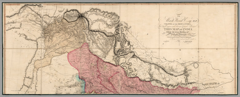
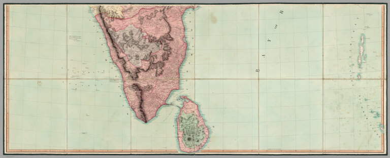
Author
Arrowsmith, Aaron
Full Title
(Upper Sheet to) To Mark Wood Esqr. M.P. colonel of the army in India late chief engineer and surveyor general, Bengal this Map of India compiled from various interesting and valuable materials is inscribed in grateful testimony of his liberal communications by ... A. Arrowsmith. London: Published by... A. Arrowsmith, 24 Rathbone Place, 1804.
List No
6732.001
Note
Large and important map of India in six sheets, joined and dissected onto three sheets.It shows British controlled areas at the turn of the century. Arrowsmith published an even larger version of the map in 1816: "With the growing influence of the British in India at the end of the eighteenth century, the need for an up-to-date general map of the sub-continent grew. The first Governor-General, Warren Hastings, employed Major Rennell who, in 1779, published his famous Bengal Atlas, followed up in 1788 by his map of India. The map itself was based upon D'Anville's map of 1752, though enriched by much new material, supplied by the numerous "route surveys" carried out by the army. As these "route surveys" began to become more numerous and accurate the need for a new general map of India soon became apparent. In 1816 Aaron Arrowsmith published his Map of India in nine sheets, on a scale of sixteen miles to an inch, which was the last great general map based on route surveys. His subsequent Atlas of South India, published in 1822, was based upon the trigonometrical surveys of Colonel Lambton, filled in by the officers of the Madras Institute."
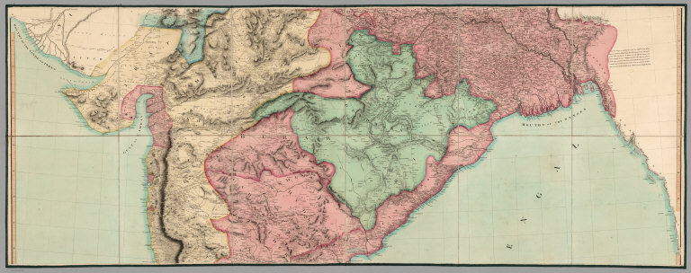
Author
Arrowsmith, Aaron
Full Title
(Middle Sheet to) To Mark Wood Esqr. M.P. colonel of the army in India late chief engineer and surveyor general, Bengal this Map of India compiled from various interesting and valuable materials is inscribed in grateful testimony of his liberal communications by ... A. Arrowsmith. London: Published by... A. Arrowsmith, 24 Rathbone Place, 1804.
List No
6732.002
Note
Large and important map of India in six sheets, joined and dissected onto three sheets.It shows British controlled areas at the turn of the century. Arrowsmith published an even larger version of the map in 1816: "With the growing influence of the British in India at the end of the eighteenth century, the need for an up-to-date general map of the sub-continent grew. The first Governor-General, Warren Hastings, employed Major Rennell who, in 1779, published his famous Bengal Atlas, followed up in 1788 by his map of India. The map itself was based upon D'Anville's map of 1752, though enriched by much new material, supplied by the numerous "route surveys" carried out by the army. As these "route surveys" began to become more numerous and accurate the need for a new general map of India soon became apparent. In 1816 Aaron Arrowsmith published his Map of India in nine sheets, on a scale of sixteen miles to an inch, which was the last great general map based on route surveys. His subsequent Atlas of South India, published in 1822, was based upon the trigonometrical surveys of Colonel Lambton, filled in by the officers of the Madras Institute."
Author
Arrowsmith, Aaron
Full Title
(Lower Sheet to) To Mark Wood Esqr. M.P. colonel of the army in India late chief engineer and surveyor general, Bengal this Map of India compiled from various interesting and valuable materials is inscribed in grateful testimony of his liberal communications by ... A. Arrowsmith. London: Published by... A. Arrowsmith, 24 Rathbone Place, 1804.
List No
6732.003
Note
Large and important map of India in six sheets, joined and dissected onto three sheets.It shows British controlled areas at the turn of the century. Arrowsmith published an even larger version of the map in 1816: "With the growing influence of the British in India at the end of the eighteenth century, the need for an up-to-date general map of the sub-continent grew. The first Governor-General, Warren Hastings, employed Major Rennell who, in 1779, published his famous Bengal Atlas, followed up in 1788 by his map of India. The map itself was based upon D'Anville's map of 1752, though enriched by much new material, supplied by the numerous "route surveys" carried out by the army. As these "route surveys" began to become more numerous and accurate the need for a new general map of India soon became apparent. In 1816 Aaron Arrowsmith published his Map of India in nine sheets, on a scale of sixteen miles to an inch, which was the last great general map based on route surveys. His subsequent Atlas of South India, published in 1822, was based upon the trigonometrical surveys of Colonel Lambton, filled in by the officers of the Madras Institute." (Lyon and Turnbull)
Author
Arrowsmith, Aaron
Full Title
(Composite Map of) To Mark Wood Esqr. M.P. colonel of the army in India late chief engineer and surveyor general, Bengal this Map of India compiled from various interesting and valuable materials is inscribed in grateful testimony of his liberal communications by ... A. Arrowsmith. London: Published by... A. Arrowsmith, 24 Rathbone Place, 1804.
List No
6732.004
Note
Large and important map of India in six sheets, joined and dissected onto three sheets.It shows British controlled areas at the turn of the century. Arrowsmith published an even larger version of the map in 1816: "With the growing influence of the British in India at the end of the eighteenth century, the need for an up-to-date general map of the sub-continent grew. The first Governor-General, Warren Hastings, employed Major Rennell who, in 1779, published his famous Bengal Atlas, followed up in 1788 by his map of India. The map itself was based upon D'Anville's map of 1752, though enriched by much new material, supplied by the numerous "route surveys" carried out by the army. As these "route surveys" began to become more numerous and accurate the need for a new general map of India soon became apparent. In 1816 Aaron Arrowsmith published his Map of India in nine sheets, on a scale of sixteen miles to an inch, which was the last great general map based on route surveys. His subsequent Atlas of South India, published in 1822, was based upon the trigonometrical surveys of Colonel Lambton, filled in by the officers of the Madras Institute."
Author
Arrowsmith, Aaron
Full Title
(Covers to) To Mark Wood Esqr. M.P. colonel of the army in India late chief engineer and surveyor general, Bengal this Map of India compiled from various interesting and valuable materials is inscribed in grateful testimony of his liberal communications by ... A. Arrowsmith. London: Published by... A. Arrowsmith, 24 Rathbone Place, 1804.
List No
6732.005
Note
Large and important map of India in six sheets, joined and dissected onto three sheets.It shows British controlled areas at the turn of the century. Arrowsmith published an even larger version of the map in 1816: "With the growing influence of the British in India at the end of the eighteenth century, the need for an up-to-date general map of the sub-continent grew. The first Governor-General, Warren Hastings, employed Major Rennell who, in 1779, published his famous Bengal Atlas, followed up in 1788 by his map of India. The map itself was based upon D'Anville's map of 1752, though enriched by much new material, supplied by the numerous "route surveys" carried out by the army. As these "route surveys" began to become more numerous and accurate the need for a new general map of India soon became apparent. In 1816 Aaron Arrowsmith published his Map of India in nine sheets, on a scale of sixteen miles to an inch, which was the last great general map based on route surveys. His subsequent Atlas of South India, published in 1822, was based upon the trigonometrical surveys of Colonel Lambton, filled in by the officers of the Madras Institute."
Author
Arrowsmith, Aaron
Full Title
Map of the World on a Globular Projection, Exhibiting Particularly the Nautical Researches of Capn. James Cook, F.R.S. with all the Recent Discoveries to the Present Time, carefully drawn by A. Arrowsmith, Hydrographer to H.R.H. the Prince of Wales. The Plan Work Engraved by T. Foot. The Writing by Wigzell & Mozeen. This Map Is Respectfully Dedicated To Alexander Dalrymple Esqr. F.R.S. In Testimony of his many New and Valuable Geographical Communications To His most Obedient and very Humble Servant A. Arrowsmith. January 1st 1794. Additions to 1799. Do. to 1808. London, Published as the Act direct Jany. 1st 1794, by A. Arrowsmith, No. 10 Soho Square. I. Puke Sculpt. E. Dayes del. W. Wilson sculp.
List No
0030.000
Note
Dedicated to Alexander Dalrymple. Portraits of Cook and Dalrymple. 1st edition, 1794. Additions to 1799 and 1808. With outline color by country. Map is dissected into 24 sections, mounted on linen and edged in light blue silk. Folds into a new brown cloth folding case 34x27 with "World On A Globular Projection A. Arrowsmith 1808" stamped in gold on the spine.
Author
Humboldt, Alexander von, 1769-1859
Full Title
Points de partage et Communications projettees entre le Grand Ocean et l' Ocean Atlantique. (with) eight maps. 4. Dessines par J.B. Poirson. Grave par Barriere - et l'ecriture par L. Aubert.
List No
0328.006
Note
Eight uncolored maps showing possible communication points, and passageways from the Pacific Ocean to the Atlantic. The largest map is entitled: Carte de l'Isthme de Huasacualco.
Author
Arrowsmith, Aaron
Full Title
A Map Exhibiting all the New Discoveries in the Interior Parts of North America, Inscribed by Permission To the Honorable Governor and Company of Adventurers of England Trading into Hudsons Bay. In testimony of their liberal Communications. To Their most Obedient and very Humble Servant, A. Arrowsmith. Hydrographer to H.R.H. the Prince of Wales. No. 10 Soho Square. January 1st, 1795. Additions to 1811. Puke Sc.
List No
4189.000
Note
This issue is the seventh (Heckrotte) and makes changes to the Canadian waterways, when compared to the 1802 editions. The American West has been largely unchanged since the first issue of 1795. In the next issue (1814) there are massive changes in the American West. Map in light outline color.
Author
Arrowsmith, Aaron
Full Title
(Covers to) A Map Exhibiting all the New Discoveries in the Interior Parts of North America Inscribed by Permission To the Honorable Governor And Company Of Adventurers Of England Trading Into Hudson Bay In testimony of their liberal Communications To their most Obedient and very Humble Servant, A. Arrowsmith, Hydrographer to H.R.H. the Prince of Wales. No. 10 Soho Square, January 1st 1795. Additions to 1811. Additions to 1814. London: Published Jan. 1, 1795 by A. Arrowsmith No. 10 Soho Square. Additions to 1802 ...
List No
0032A
Author
Arrowsmith, Aaron
Full Title
A Map Exhibiting all the New Discoveries in the Interior Parts of North America Inscribed by Permission To the Honorable Governor And Company Of Adventurers Of England Trading Into Hudson Bay In testimony of their liberal Communications To their most Obedient and very Humble Servant, A. Arrowsmith, Hydrographer to H.R.H. the Prince of Wales. No. 10 Soho Square, January 1st 1795. Additions to 1811. Additions to 1814. London: Published Jan. 1, 1795 by A. Arrowsmith No. 10 Soho Square. Additions to 1802 ...
List No
0032.001
Note
This issue incorporates the Lewis and Clark discoveries (and other discoveries) and remaps the entire continent west of the Mississippi. The changes between this and the last edition (1811) are monumental. This copy is from the collection of Sir Charles Broke (or Brooke, subsequently Vere). Broke was in Lower Canada with his regiment, the 5th (Northumberland) Regiment of Foot, which was at the battle of Plattsburg in 1814. Later, he was with the Army of Occupation in France, receiving the Waterloo medal despite arriving from Canada too late for the battle (from Manasek). Without color. Dissected into 40 sections and mounted on linen. Folds into a new gray cloth covered box case 29x22x7 with "North America A. Arrowsmith 1814" stamped on the spine in gold.
Author
Arrowsmith, Aaron
Full Title
A map exhibiting all the new discoveries in the interior parts of North America, inscribed by permission to the Honorable Governor and Company of Adventurers of England trading into Hudson Bay, in testimony of their liberal communications to their most obedient and very humble servant, A. Arrowsmith, Hydrographer to H.R.H. the Prince of Wales. (Sheet 1). No. 10 Soho Square. January 1st, 1795 -- additions to 1811, 1818.
List No
5699.001
Note
Engraved map. Hand col. Relief shown by hachures. Sheet 1 of 3. Shows settlements, Indian tribes, rivers, etc. In lower margin: London, Published 1 Jan. 1795 by A. Arrowsmith ... additions to 1802. Below title: Additions to June 1814. Printed on 2 sheets, joined together.
Author
Arrowsmith, Aaron
Full Title
(A map exhibiting all the new discoveries in the interior parts of North America, inscribed by permission to the Honorable Governor and Company of Adventurers of England trading into Hudson Bay, in testimony of their liberal communications to their most obedient and very humble servant, A. Arrowsmith, Hydrographer to H.R.H. the Prince of Wales. Sheet 2.) London: Published Jan. 1, 1795 by A. Arrowsmith, No. 10 Soho Square -- additions to 1802. (1818)
List No
5699.002
Note
Engraved map. Hand col. Relief shown by hachures. Sheet 2 of 3. Shows settlements, Indian tribes, rivers, etc. Printed on 2 sheets, joined together.
Author
Arrowsmith, Aaron
Full Title
(A map exhibiting all the new discoveries in the interior parts of North America, inscribed by permission to the Honorable Governor and Company of Adventurers of England trading into Hudson Bay, in testimony of their liberal communications to their most obedient and very humble servant, A. Arrowsmith, Hydrographer to H.R.H. the Prince of Wales. Sheet 3.) London: Published 1 Jan. 1795 by A. Arrowsmith, No. 10 Soho Square -- additions to 1802. (1818)
List No
5699.003
Note
Engraved map. Hand col. Relief shown by hachures. Sheet 3 of 3. Shows settlements, Indian tribes, rivers, etc. Printed on 2 sheets, joined together.
Author
Arrowsmith, Aaron
Full Title
(Composite of) A map exhibiting all the new discoveries in the interior parts of North America, inscribed by permission to the Honorable Governor and Company of Adventurers of England trading into Hudson Bay, in testimony of their liberal communications to their most obedient and very humble servant, A. Arrowsmith, Hydrographer to H.R.H. the Prince of Wales. No. 10 Soho Square. January 1st, 1795 -- additions to 1811, 1818.
List No
5699.004
Note
Engraved map on 3 sheets. Hand col. Relief shown by hachures. Shows settlements, Indian tribes, rivers, etc. In lower margin: London, Published 1 Jan. 1795 by A. Arrowsmith ... additions to 1802. Below title: Additions to June 1814. Printed on 6 sheets, joined together as 3.
Author
Tanner, Henry S.
Full Title
(Geographical Memoir, pg. 18 in) A New American Atlas Containing Maps Of The Several States of the North American Union, Projected and drawn on a Uniform Scale from Documents found in the public Offices of the United States and State Governments, and other Original and Authentic Information, By Henry S. Tanner ... Philadelphia: Published By H.S. Tanner. 1823. (title page only) Writing Drawn and Engraved by Joseph Perkins. Barralet del. Humphrys sc.
List No
5388N
Note
Remainder of the Geographical Memoir. "To The Public" is a note from Tanner to the public about the accuracy of his data and includes a request to "respectfully...solicit communications for their future corrections."
Author
Tanner, Henry S.
Full Title
(Geographical Memoir, pg. 18 in) A New American Atlas Containing Maps Of The Several States of the North American Union, Projected and drawn on a Uniform Scale from Documents found in the public Offices of the United States and State Governments, and other Original and Authentic Information, By Henry S. Tanner ... Philadelphia: Published By H.S. Tanner. 1823. (title page only) Writing Drawn and Engraved by Joseph Perkins. Barralet del. Humphrys sc.
List No
5022.014
Note
Remainder of the Geographical Memoir. "To The Public" is a note from Tanner to the public about the accuracy of his data and includes a request to "respectfully...solicit communications for their future corrections."
Author
Desjardins, Constant
Full Title
Industriell-Commercielle Karte von Europa, oder Skizze der europ. Staaten nach ihren Gewerbs- und Handelsverhaltnissen, nebst Angabe ihrer wichtigsten Handelsplatze, Strassen, Kanale, Eisenbahnen, Dampfschiffsfahrten, etc. etc., der Jugend gewidmet von C. Desjardins. (pasted on at bottom:) Europa's Reichthum in den wichtigsten Erzeugnissen. Beilage zu Nro. 6 des Desjardinschen geographisch-historischen Atlasses. (1837)
List No
0242.006
Note
Color map. Includes text and tables. Prime meridians: Paris and Ferro.
Author
[Wyld, James, 1812-1887, Wyld, James, 1790-1836]
Full Title
Map of Ireland divided into Provinces and Counties, shewing the great and cross roads with the distances of the principal towns from Dublin : also the steam communications from the outports, and the average time of journey. Published by Js. Wyld. 1838. (to accompany) A new general atlas of modern geography : consisting of a complete collection of maps of the four quarters of the globe ...
List No
13170.015
Note
Double page engraved map, hand colored in outline. Showing administrative divisions, roads, cities and towns. Relief shown by hachures and shadings.
Author
[IRISH RAILWAY COMMISSION, HARNESS, Henry Drury (1804 - 1883), Griffith, Richard John (1784-1878), LARCOM, Thomas Aiskew (1801 - 1879)]
Full Title
(Covers to) Irish Railway Commission. Maps / Presented to both Houses of Parliament by command of Her Majesty. 1838. [Atlas to accompany 2d. Report of the Railway Commissioners, Ireland].
List No
15443.001
Author
[IRISH RAILWAY COMMISSION, HARNESS, Henry Drury (1804 - 1883), Griffith, Richard John (1784-1878), LARCOM, Thomas Aiskew (1801 - 1879)]
Full Title
(Title page to) Irish Railway Commission. Maps / Presented to both Houses of Parliament by command of Her Majesty. 1838. [Atlas to accompany 2d. Report of the Railway Commissioners, Ireland].
List No
15443.002
Author
[IRISH RAILWAY COMMISSION, LARCOM, Thomas Aiskew (1801 - 1879)]
Full Title
I. Map of Ireland to accompany the Report of the Railway Commissioners 1838. Shewing the lines laid down Under the Direction of the Commissioners and those proposed by Private Parties. / Prepared & Engraved under the direction of Lieu.t Larcom Royal Eng.rs May 1837.
List No
15443.003
Author
[IRISH RAILWAY COMMISSION, HARNESS, Henry Drury (1804 - 1883)]
Full Title
II. Map of Ireland to accompany the Report of the Railway Commissioners shewing the comparative Density of Population. Constructed under the Direction of the Commissioners by Henry D. Harness Lt. Royal Engineers 1837.
List No
15443.004
Author
[IRISH RAILWAY COMMISSION, HARNESS, Henry Drury (1804 - 1883)]
Full Title
III. Map of Ireland, to accompany the Report of the Railway Commissioners shewing the relative Quantities of Traffic in different Directions. Constructed under the Direction of the Commissioners by Henry D. Harness Lt. Royal Engineers 1837.
List No
15443.005
Author
[IRISH RAILWAY COMMISSION, HARNESS, Henry Drury (1804 - 1883)]
Full Title
IV. Map of Ireland, to accompany the Report of the Railway Commissioners shewing the relative Number of Passengers in different Directions by regular Public Conveyances. Constructed under the Direction of the Commissioners by Henry D. Harness Lt. Royal Engineers 1837.
List No
15443.006
Author
[IRISH RAILWAY COMMISSION, Griffith, Richard John (1784-1878)]
Full Title
V. Geological Map of Ireland to accompany the Report of the Railway Commissioners 1837 / Shewing the lines laid down Under the Direction of the Commissioners and those proposed by Joint Stock Companies.
List No
15443.007
Author
[IRISH RAILWAY COMMISSION, LARCOM, Thomas Aiskew (1801 - 1879)]
Full Title
VI. Map of England and Ireland, Explanatory of that part of the Report of the Railway Commissioners, which relates to communication between London and Dublin, and other parts of Ireland. / Prepared & Engraved under the direction of Lieu.t Larcom Royal Eng.rs May 1837.
List No
15443.008
Author
Meyerson, Leo
Full Title
Radio Reference Map of the United States. World Radio Laboratories.
List No
9787.001
Author
[Martin, R.M., Tallis, J. & F.]
Full Title
Isthmus of Panama. The Illustrations by H. Warren & Engraved by J. Wrightson. The Map Drawn & Engraved by J. Rapkin.
List No
0466.074
Note
Outline color map extending from Honduras to the top of New Granada. The proposed railway and canal communications are colored in pink. Inset illustrations include gold seekers on their way over the Cordilleras and the fort at Chagres. Surrounded by a filigree border.
Author
[Martin, R.M., Tallis, J. & F.]
Full Title
Isthmus of Panama. The Illustrations by H. Warren & Engraved by J. Wrightson. The Map Drawn & Engraved by J. Rapkin.
List No
10095.075
Note
Outline color map extending from Honduras to the top of New Granada. The proposed railway and canal communications are colored in pink. Inset illustrations include gold seekers on their way over the Cordilleras and the fort at Chagres. Surrounded by a filigree border.
Author
Sagansan, L.
Full Title
Carte de la Telegraphie Electrique De L'Europe Dressee par ordre de M. Le Viomte de Vougy Directeur Genral de l'Administration des Lignes Telegraphiques par L. Sagansan Geographe de S.M. Empereur et de l'Administraion des Postes Paris
List No
10473.000
Note
One of the Earliest Telegraph Maps of Europe Extremely rare early map illustrating the progress of providing telegraph lines throughout Europe. This may be the earliest thematic map which focuses solely on telegraph lines across all of Europe. The map illustrates the telegraph lines then in operation, those under construction and the Telegraph Directorates and Bureaus. Among the more noteworthy connections are the cable across the English Channel, the Cable extending to Corsica and the proposed cable from Sardinia to North Africa. History of the Telegraph The first working telegraph was built by the English inventor Francis Ronalds in 1816 and used static electricity. Offering his invention to the Admiralty in July 1816, it was rejected as "wholly unnecessary". The telegraph invented by Baron Schilling von Canstatt in 1832 had a transmitting device which consisted of a keyboard with 16 black-and-white keys. Pavel Schilling subsequently improved its apparatus. The first commercial electrical telegraph was the Cooke and Wheatstone system. A demonstration four-needle system was installed on the Euston to Camden Town section of Robert Stephenson's London and Birmingham Railway in 1837 for signaling rope-hauling of locomotives. It was rejected in favor of pneumatic whistles. Cooke and Wheatstone had their first commercial success with a system installed on the Great Western Railway over the 13 miles from Paddington station to West Drayton in 1838. The Electric Telegraph Company, the world's first public telegraphy company was formed in 1845 by financier John Lewis Ricardo and Cooke. In 1851, a conference in Vienna of countries in the German-Austrian Telegraph Union adopted the Morse telegraph as the system for international communications. The code adopted was considerably modified from the original Morse code, and was based on a code used on Hamburg railways (Gerke, 1848). A common code was a necessary step to allow direct telegraph connection between countries. With different codes, additional operators were required to translate and retransmit the message. As well as the rapid expansion of the use of the telegraphs along the railways, they soon spread into the field of mass communication with the instruments being installed in post offices. Telegraph networks were expensive to build, but financing was readily available, especially from London bankers. By 1852, National systems were in operation in major countries The Bibliotheque National de France holds an 1855 edition, which shows a number of new telegraph lines, most notably one across the Black Sea and one from Moscow to Odessa. (Ruderman, 2020)
Author
Willmer & Rogers
Full Title
(Covers to) Chart of The North & Baltic Seas &c. Showing the Lines of Steam Boat Communications, Soundings &c. Published by Willmer & Rogers Importers of Foreign Books & News Papers 42 & 44 Nassau Street New York. Lith & Print by Bevan & Boell, 163 Broadway N.Y. (inset) Harbour Of Heligoland. (inset) Port Of Revel. (inset) Harbour Of St. Petersburg.
List No
3171.001
Note
Unknown maker, probably copied from British chart. The question that comes to mind about this map is why was it published? Outline color. Map is folded into green card board covers 18x11 with "A New Chart Of The North & Baltic Seas, With Plans Of The Harbors Of St. Petersburgh, Revel, &c. New-York: Published by Willmer & Rogers ... 1854. Price 25 Cents." Prime meridian West Longitude. East Longitude.
Author
Willmer & Rogers
Full Title
Chart of The North & Baltic Seas &c. Showing the Lines of Steam Boat Communications, Soundings &c. Published by Willmer & Rogers Importers of Foreign Books & News Papers 42 & 44 Nassau Street New York. Lith & Print by Bevan & Boell, 163 Broadway N.Y. (inset) Harbour Of Heligoland. (inset) Port Of Revel. (inset) Harbour Of St. Petersburg.
List No
3171.002
Note
Unknown maker, probably copied from British chart. The question that comes to mind about this map is why was it published? Outline color. Map is folded into green card board covers 18x11 with "A New Chart Of The North & Baltic Seas, With Plans Of The Harbors Of St. Petersburgh, Revel, &c. New-York: Published by Willmer & Rogers ... 1854. Price 25 Cents." Prime meridian West Longitude. East Longitude.
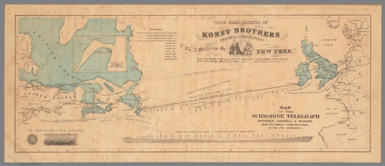
Author
Korff Brothers
Full Title
Map of the Submarine Telegraph between America and Europe, with its various communications on the two continents.
List No
12052.000
Note
Date estimated.
Author
Mitchell, Samuel Augustus
Full Title
Venezuela, New Grenada & Equador. Entered ... 1856 by Charles Desilver ... Pennsylvania. (inset) Map of the Communications by Railroad across the Isthmus of Darien from Victor Bay to Panama.
List No
2514.045
Note
Full color map. Shows capitals, and important towns. Relief shown by hachures. Prime meridian is Washington.
Author
Mitchell, Samuel Augustus
Full Title
Venezuela, New Grenada & Equador. Entered according to Act of Congress in the year 1856 by Charles Desilver in the Clerk's office if the District Court of the Eastern District of Pennsylvania. 43.
List No
4557.042
Note
States tinted in color. Meridian Washington. Relief shown by hachures. Inset of the Map of the Communications by Railroad across the Isthmus of Darien from Aspinwall to Panama.
Author
Mitchell, Samuel Augustus
Full Title
Venezuela, New Grenada & Equador. 43. Entered ... 1859, by Charles Desilver ... Pennsylvania. (inset) Map of the Communications by Railroad across the Isthmus of Darien from Aspinwall to Panama. (to accompany) A New Universal Atlas Containing Maps of the various Empires, Kingdoms, States and Republics Of The World.
List No
8065.046
Note
Colored by states. Prime Meridian is Washington. Relief shown by hachures. Shows capitals, railroads, major cities and towns.
Author
Chatelain, Anatole Julien (1817 - 1898)
Full Title
(Covers to) Carte des voies de communication établies dans le Monde entier, au moyen de la vapeur et de l'électricité; "World's Steam and Electric Map" Avec indications des Postes Consulaires de France sur le Globe dressée d’après les documents officiels très récents par Anatole Chatelain Ex-Chef du Bureau de la Statistique au Ministère des Affaires Étrangères et dédiée a S.M. l’Empereur.
List No
15798.001
Author
Chatelain, Anatole Julien (1817 - 1898)
Full Title
Carte des voies de communication établies dans le Monde entier, au moyen de la vapeur et de l'électricité; "World's Steam and Electric Map" Avec indications des Postes Consulaires de France sur le Globe dressée d’après les documents officiels très récents par Anatole Chatelain Ex-Chef du Bureau de la Statistique au Ministère des Affaires Étrangères et dédiée a S.M. l’Empereur.
List No
15798.002
Author
Electric & International Telegraph Company
Full Title
Map of Europe, compiled from the most recent Surveys Published for the Electric & International Telegraph Company Shewing the System of Telegraphs with which they are connected. 1863. H. Weaver, Secretary, E. & I .T. Co.
List No
12182.002
Author
Ziegler, J. M.
Full Title
Handels und Colonial-Karte. Nach Mercators Projection. Zum Atlas v. J.M. Ziegler. Verlag, Stich u. Druck der topogr. Anstalt v. J. Wurster u. Comp. in Winterthur. (1864)
List No
2227.002
Note
Colored map. Relief shown by hachures. Shows ocean currents, submarine telegraph lines, shipping lanes, etc. Insets: Wasser-Halbkuge -- Land-Halbkugel. Prime meridians: Ferro and Greenwich.
Author
Ziegler, J. M.
Full Title
Hauptverbindungslinien von Europa als Mittelpunkt des Weltverkehrs. Zum Atlas von J.M. Ziegler. Topogr. Anstalt v. Joh. Wurster u. Comp. in Winterthur. Winterthur, Verlag v. J. Wurster & Comp. (1864)
List No
2227.003
Note
Colored map. Relief shown by hachures. Shows railroads, submarine telegraph lines, major telegraph stations, etc. Prime meridian: Ferro.
Author
Ziegler, J. M.
Full Title
Asien. Zum Atlas von J.M. Ziegler. Topogr. Anstalt v. J. Wurster u. Comp in Winterthur. (1864)
List No
2227.004
Note
Colored map. Relief shown by hachures. Shows colonial and political divisions, telegraph stations, submarine telegraph lines, treaty ports in China, etc. Prime meridian: Ferro.
Author
Mitchell, Samuel Augustus
Full Title
Venezuela, New Grenada & Equador. Entered according to Act of Congress in the year 1860 by Charles Desilver in the Clerk's office if the District Court of the Eastern District of Pennsylvania. 43.
List No
6727.046
Note
States tinted in color. Meridian Washington. Relief shown by hachures. Inset of the Map of the Communications by Railroad across the Isthmus of Darien from Aspinwall to Panama.
Author
Colton, G.W.
Full Title
Colton's United States of America. Published By J. H. Colton. No. 172 William St. New York.
List No
0151.022
Note
Prime meridians are Greenwich and Washington D. C. Relief shown by hachures.
Author
Colton, G.W.
Full Title
Colton's Georgetown and the City of Washington the Capital of the United States of America. Published By J. H. Colton. No. 172 William St. New York.
List No
0151.023
Note
Map showing districts, roads and layout of various buildings. (inset) Smithsonian Institution, The Capital and Washington Monument.
Author
Colton, G.W.
Full Title
Colton's Maine. Published By J. H. Colton. No. 172 William St. New York.
List No
0151.024
Note
Map showing the county boundaries in color. Prime meridians are Greenwich and Washington D. C.
Author
Colton, G.W.
Full Title
Colton's New Hampshire. Published By J. H. Colton. No. 172 William St. New York.
List No
0151.025
Note
Map showing the county boundaries in color. Prime meridians are Greenwich and Washington D. C.
|


![Covers: Irish Railway Commission. Maps / Presented to both Houses of Parliament by command of Her Majesty. 1838. [Atlas to accompany 2d. Report of the Railway Commissioners, Ireland].](https://www.davidrumsey.com/rumsey/Size2/RUMSEY~8~1/205/15443001.jpg)
![Title: Irish Railway Commission. Maps / Presented to both Houses of Parliament by command of Her Majesty. 1838. [Atlas to accompany 2d. Report of the Railway Commissioners, Ireland].](https://www.davidrumsey.com/rumsey/Size1/RUMSEY~8~1/205/15443002.jpg)