Who What Where WhenWHATShow MoreWHERE
|
Author
Hayward, James
Full Title
(Title Page to) Report of the Board of Commissioners, of Internal Improvement in Relation to the Examination of Sundry Routes for a Railway from Boston to Providence. With a Memoir of the Survey. Senate No. 4. Boston: Dutton & Wentworth...Printers to the State ... 1828. (with) Plan of A Survey For the Proposed Boston and Providence Rail-Way. by James Hayward. Jan. 1828. Annin & Smith.
List No
0324.001
Note
Earliest Rairoad map in LOC collection. Sabin provides report publication data. Map is uncolored and measures 19x106 at a scale of 1:63,360 (1 inch=1 mile).
Author
Hayward, James
Full Title
(Text Page to) Commonwealth of Massachusetts. Paul Willard, Clerk. Jan. 26, 1828. To His Excellency Levi Lincoln, Joshiah J. Fiske, Chairman, Boston, January 24, 1828. (to accompany) Report of the Board of Commissioners, of Internal Improvement in Relation to the Examination of Sundry Routes for a Railway from Boston to Providence.
List No
0324.002
Note
Text on 2 pages. Earliest Rairoad map in LOC collection. Sabin provides report publication data. Map is uncolored and measures 19x106 at a scale of 1:63,360 (1 inch=1 mile).
Author
Hayward, James
Full Title
(Text Page to) Message. (to accompany) Report of the Board of Commissioners, of Internal Improvement in Relation to the Examination of Sundry Routes for a Railway from Boston to Providence.
List No
0324.003
Note
Message to the Senate and House of Representatives by Levi Lincoln. Jan 25, 1828. Earliest Rairoad map in LOC collection. Sabin provides report publication data. Map is uncolored and measures 19x106 at a scale of 1:63,360 (1 inch=1 mile).
Author
Hayward, James
Full Title
(Text Page to) Message. (to accompany) Report of the Board of Commissioners, of Internal Improvement in Relation to the Examination of Sundry Routes for a Railway from Boston to Providence.
List No
0324.004
Note
Message to the Senate and House of Representatives by Levi Lincoln. Jan 25, 1828. Earliest Rairoad map in LOC collection. Sabin provides report publication data. Map is uncolored and measures 19x106 at a scale of 1:63,360 (1 inch=1 mile).
Author
Hayward, James
Full Title
(Text Page to) Message. (to accompany) Report of the Board of Commissioners, of Internal Improvement in Relation to the Examination of Sundry Routes for a Railway from Boston to Providence.
List No
0324.005
Note
Message to the Senate and House of Representatives by Levi Lincol. Jan 25, 1828. Earliest Rairoad map in LOC collection. Sabin provides report publication data. Map is uncolored and measures 19x106 at a scale of 1:63,360 (1 inch=1 mile).
Author
Hayward, James
Full Title
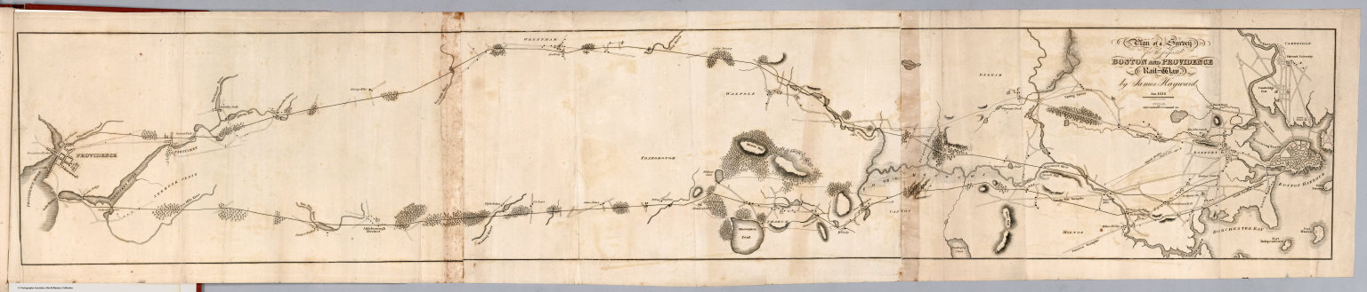
Plan of a survey for the proposed Boston and Providence rail way. By James Hayward. Jan. 1828. (engraved by) Annin & Smith. (to accompany) Report of the Board of Commissioners, of Internal Improvement in Relation to the Examination of Sundry Routes for a Railway from Boston to Providence.
List No
0324.006
Note
Map is uncolored. Shows 2 possible routes between Boston and Providence. Relief shown by hachures.
Author
Colby, Thomas
Full Title
(Covers to) Ordnance Survey of the County of Londonderry. Colonel Colby, R.E., F.R.S.L. and E., M.R.I.A., etc. Superintendent. Volume the First. Dublin: Published for Her Majesty's Government. Hodges and Smith. Dublin. 1837.
List No
7853.001
Note
Rebound with preserved original blind stamped boards and spine strip. Lettering in gilt on spine: "Ordnance Survey of Ireland. County of Londonderry, Vol.1. City and N. Western Liberties".
Author
Colby, Thomas
Full Title
(Title Page) Ordnance Survey of the County of Londonderry. Colonel Colby, R.E., F.R.S.L. and E., M.R.I.A., etc. Superintendent. Volume the First. Dublin: Published for Her Majesty's Government. Hodges and Smith. Dublin. 1837.
List No
7853.002
Author
Colby, Thomas
Full Title
(Title Page) Memoir of the City and North Western Liberties of Londonderry. Parish of Templemore.
List No
7853.003
Author
Colby, Thomas
Full Title
(Text Page) Preface.
List No
7853.004
Author
Colby, Thomas
Full Title
(Text Page) Preface. Preliminary Notice.
List No
7853.005
Author
Colby, Thomas
Full Title
(Text Page) Preliminary Notice.
List No
7853.006
Author
Colby, Thomas
Full Title
(Advertisement) (Index Page) Table of Contents.
List No
7853.007
Author
Colby, Thomas
Full Title
Geological Map of the Parish of Templemore (Irish: An Teampall Mór, meaning "The Big Church").
List No
7853.008
Note
Color map.
Author
Colby, Thomas
Full Title
City of Londonderry. 1835.
List No
7853.009
Note
Facsimile.
Author
Colby, Thomas
Full Title
Derry. A.D. 1600. Ordnance Survey Office. From a M.S. in the Library of Trinity College, Dublin. Engraved by Geo. McCoy.
List No
7853.010
Note
Facsimile.
Author
Colby, Thomas
Full Title
Londonderry. 1625. Ordnance Survey Office. From a M.S. in the Library of Trinity College, Dublin. Engraved by G. Muir.
List No
7853.011
Note
Facsimile.
Author
Colby, Thomas
Full Title
Londonderry from Neville's Map of the Siege. 1689. Ordnance Survey Office. Eng'd. by Sargeant West H.S.M.
List No
7853.012
Note
Facsimile.
Author
Colby, Thomas
Full Title
Londonderry. 1788. Ordnance Survey Office. Eng'd. by Sargeant West H.S.M.
List No
7853.013
Note
Facsimile.
Author
Colby, Thomas
Full Title
Londonderry. 1835. Ordnance Survey Office. The Hills by Lieut. Dawson, R.E. Engraved by J. Duncan.
List No
7853.014
Note
Relief shown by hachures. Facsimile.
Author
Colby, Thomas
Full Title
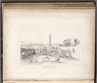
(View) Londonderry from the S.W. Bastion. Ordnance Survey Office. Drawn by G. Petric Esqr. from a Sketch by Lt. Dawson, R.E. Engraved by J. Duncan.
List No
7853.015
Author
Colby, Thomas
Full Title
The Grianan of Aileach. (Irish: Grianán Ailigh, sometimes anglicised Greenan Ely). Ordnance Survey Office. Drawn from a Sketch by Lieut. Dawson, R.E. Engraved by J. Duncan.
List No
7853.016
Note
Includes profile.
Author
Colby, Thomas
Full Title
The Cashel of the Grianan of Aileach. (Irish: Grianán Ailigh, sometimes anglicised Greenan Ely). Ordnance Survey Office. From a Sketch by Lieut. Dawson, R.E. Engraved by J. Duncan.
List No
7853.017
Author
Colby, Thomas
Full Title
Donalong (Fort). From a M.S. in the Library of Trinity College, Dublin. Fort of Coolmore. From a M.S. by Sir Thomas Phillips about 1625. Ordnance Survey Office. Engd. by Sergeant West R.S.M.
List No
7853.018
Note
Facsimile.
Author
Colby, Thomas
Full Title
(View) Notices. Plate 1. Fossil Crustacea. Natural History. Ordnance Survey. Geo. V.Du.Noyer, Delt. J. Macaulay, Sculpt. 1837.
List No
7853.019
Author
Colby, Thomas
Full Title
(View) Notices. Plate 2. Fossil Crustacea. Natural History. Ordnance Survey. Geo. V.Du.Noyer, Delt. Geo. S. Rule, Sculpt. 1837.
List No
7853.020
Author
Colby, Thomas
Full Title
(View) Notices. Plate 3. Fossils. Natural History. Ordnance Survey. Geo. V.Du.Noyer, Delt. J. Reed, Sculpt. 1837.
List No
7853.021
Author
Colby, Thomas
Full Title
(View) Notices. Plate 4. Calamagrostis Lapponica Wahlenberg. Natural History. Ordnance Survey. Geo. V.Du.Noyer, Delt. J. Duncan, Sculpt. 1837.
List No
7853.022
Author
Colby, Thomas
Full Title
(View) Notices. Plate 5. Carex Buxbaumii Wahlenberg. Natural History. Ordnance Survey. Geo. V.Du.Noyer, Delt. G. McCoy, Sculpt. 1837.
List No
7853.023
Author
Colby, Thomas
Full Title
(View) Notices. Plate 6. Polysiphonia Atropurpurea, M.S.S. Natural History. Ordnance Survey. Geo. V.Du.Noyer, Delt. W. Architald, Sculpt. 1837.
List No
7853.024
Author
Colby, Thomas
Full Title
(View) Notices. Plate 7. Polysiphonia Affinis, M.S.S. Natural History. Ordnance Survey. Geo. V.Du.Noyer, Delt. J.J. Macaulay, Sculpt. 1837.
List No
7853.025
Author
[Colby, Thomas, James, Colonel H.]
Full Title
Sheet 11. Londonderry. Ordnance Survey of Ireland. (One Inch to a Mile).
List No
7853.026
Note
Added map from later date. Bound in back of volume. Date based on handwritten note; printed date 1862. Relief shown in hachures.
Author
Whitney, Asa.
Full Title
(Title Page to) Memorial of A. Whitney, Praying A grant of public land to enable him to construct a railroad from lake Michigan to the Pacific Ocean. February 24, 1846. [Senate.] 29th Congress, 1st Session. [161].
List No
2725.001
Note
1 map; this issue not listed in Howes. Map is untitled, uncolored and by O.H. Throop. It shows the finished, unfinished, and proposed railway lines across the United States. Report housed in a cloth covered case with the title and date on the spine.
Author
Whitney, Asa.
Full Title
(Text Page to) Memorial of A. Whitney, Praying A grant of public land to enable him to construct a railroad from lake Michigan to the Pacific Ocean. February 24, 1846. [Senate.] 29th Congress, 1st Session. [161].
List No
2725.002
Note
1 map; this issue not listed in Howes. Map is untitled, uncolored and by O.H. Throop. It shows the finished, unfinished, and proposed railway lines across the United States. Report housed in a cloth covered case with the title and date on the spine.
Author
Whitney, Asa.
Full Title
(Text Page to) Memorial of A. Whitney, Praying A grant of public land to enable him to construct a railroad from lake Michigan to the Pacific Ocean. February 24, 1846. [Senate.] 29th Congress, 1st Session. [161].
List No
2725.003
Note
1 map; this issue not listed in Howes. Map is untitled, uncolored and by O.H. Throop. It shows the finished, unfinished, and proposed railway lines across the United States. Report housed in a cloth covered case with the title and date on the spine.
Author
Whitney, Asa.
Full Title
(Text Page to) Memorial of A. Whitney, Praying A grant of public land to enable him to construct a railroad from lake Michigan to the Pacific Ocean. February 24, 1846. [Senate.] 29th Congress, 1st Session. [161].
List No
2725.004
Note
1 map; this issue not listed in Howes. Map is untitled, uncolored and by O.H. Throop. It shows the finished, unfinished, and proposed railway lines across the United States. Report housed in a cloth covered case with the title and date on the spine.
Author
Whitney, Asa.
Full Title
(Text Page to) Memorial of A. Whitney, Praying A grant of public land to enable him to construct a railroad from lake Michigan to the Pacific Ocean. February 24, 1846. [Senate.] 29th Congress, 1st Session. [161].
List No
2725.005
Note
1 map; this issue not listed in Howes. Map is untitled, uncolored and by O.H. Throop. It shows the finished, unfinished, and proposed railway lines across the United States. Report housed in a cloth covered case with the title and date on the spine.
Author
Whitney, Asa.
Full Title
(Text Page to) Memorial of A. Whitney, Praying A grant of public land to enable him to construct a railroad from lake Michigan to the Pacific Ocean. February 24, 1846. [Senate.] 29th Congress, 1st Session. [161].
List No
2725.006
Note
1 map; this issue not listed in Howes. Map is untitled, uncolored and by O.H. Throop. It shows the finished, unfinished, and proposed railway lines across the United States. Report housed in a cloth covered case with the title and date on the spine.
Author
Whitney, Asa.
Full Title
(Map, without a title, United States and northern Mexico). Drawn & engraved by O.H. Throop. (to accompany) Memorial of A. Whitney, Praying A grant of public land to enable him to construct a railroad from lake Michigan to the Pacific Ocean. February 24, 1846. [Senate.] 29th Congress, 1st Session. [161].
List No
2725.007
Note
Map is untitled, uncolored and by O.H. Throop. It shows the finished, unfinished, and proposed railway lines across the United States. Report housed in a cloth covered case with the title and date on the spine. Title supplied by cataloger. Relief shown by hachures.
Author
Whitney, Asa
Full Title
(Title Page to) A Project For A Railroad To The Pacific. By Asa Whitney, of New York. With Reports of Committees of Congress, Resolutions of State Legislatures, Etc., with other Facts Relating Thereto. New York: Printed by George W. Wood, No. 15 Spruce Street. 1849.
List No
1466.001
Note
Two untitled maps: 1) A world map on a Mercator Projection showing the US as a central point linking Europe and Asia. 2) A map of North America showing possible rail routes across the continent. Bound report with cloth covered boards and "Railroad to the Pacific" with author and date on spine.
Author
Whitney, Asa
Full Title
(Text Page to) Preface: To the people of the United States. (by) Asa Whitney. New York, May 1949. (to accompany) A Project For A Railroad To The Pacific. By Asa Whitney, of New York. With Reports of Committees of Congress, Resolutions of State Legislatures, Etc., with other Facts Relating Thereto. New York: Printed by George W. Wood, No. 15 Spruce Street. 1849.
List No
1466.002
Note
Preface, Errata on the opposite page. Two untitled maps: 1) A world map on a Mercator Projection showing the US as a central point linking Europe and Asia. 2) A map of North America showing possible rail routes across the continent. Bound report with cloth covered boards and "Railroad to the Pacific" with author and date on spine.
Author
Whitney, Asa
Full Title
(Text Page to) Preface: To the people of the United States. (by) Asa Whitney. New York, May 1949. (to accompany) A Project For A Railroad To The Pacific. By Asa Whitney, of New York. With Reports of Committees of Congress, Resolutions of State Legislatures, Etc., with other Facts Relating Thereto. New York: Printed by George W. Wood, No. 15 Spruce Street. 1849.
List No
1466.003
Note
Preface, Errata on the opposite page. Two untitled maps: 1) A world map on a Mercator Projection showing the US as a central point linking Europe and Asia. 2) A map of North America showing possible rail routes across the continent. Bound report with cloth covered boards and "Railroad to the Pacific" with author and date on spine.
Author
Whitney, Asa
Full Title
No. 1 (World map on a Mercator Projection). "This map shews the position of our continent as compared with Europe and Africa on one side and Asia on the other, placing US in the centre". This map was prepared by Mr. Whitney for Mr. Breese's report to the Senate, U.S. 29 Congrees. Miller's Lith. 102 Broadway, N.Y. (on the lower margin) 1235. (to accompany) A Project For A Railroad To The Pacific. By Asa Whitney, of New York.
List No
1466.004
Note
Untitled map of the world map on a Mercator Projection, showing the United States as a central point linking Europe and Asia. With notes on distances and population. And "N.B. the circular lines show the air routes from place to place." Title supplied by cataloger.
Author
Whitney, Asa
Full Title
No. 2 ( A map of North America showing possible rail routes across the continent.) Miller's Lith. 102 Broadway, N.Y. "N.B. this map shews very nealy the sphere of the Globe, and the line from Baltimore and the line from Panama to Puget Sound, would be the air line route. (to accompany) A Project For A Railroad To The Pacific. By Asa Whitney, of New York.
List No
1466.005
Note
Untitled map of North America showing possible rail routes across the continent. Includes notes on Northern route and Southern route, The Galveston route and St. Louis routes, with distances in miles from place to place. Relief shown by hachures. Title supplied by cataloger.
Author
Espy, James P.
Full Title
Covers to) Espy's report on meteorology, to the Secreatary of the Navy.
List No
15876.001
Author
Espy, James P.
List No
15876.002
Author
Espy, James P.
Full Title
(Composite text to) Espy's report on meteorology, to the Secreatary of the Navy.
List No
15876.003
Author
Espy, James P.
Full Title
April 1st 1843. 3.P.M. Chart Illustrating The Weather 1843
List No
15876.004
Author
Espy, James P.
Full Title
April 2d. 1843 3 P.M. Chart Illustrating The Weather 1843
List No
15876.005
Author
Espy, James P.
Full Title
21st. April 1843 3 P.M. Chart Illustrating The Weather 1843
List No
15876.006
|