|
Author
Buache, Philippe, 1700-1773
Full Title
(Covers to) Considerations physique. (Considerations Geographiques Et Physiques Sur Les Nouvelles Decouvertes Au Nord de La Grande Mer Appellee Vulgairement La Mer Du Sud; avec des cartes, qui y sont relatives ... . par M. Phillipe Bauche. Paris 1753). Publiee sous le privilege de l'Acad. des Sciences. A Paris sur quay de l'Horloge de Palais.
List No
11780.001
Note
Atlas of the physical geography. In two volumes; the first comprising a textual description of recent discoveries in the northern part of the North Pacific Ocean, This is the second volume, part 3, including 16 double page plates, 12 maps and 4 cross sections. Covers: Arctic regions, North pacific Ocean, Pacific Coast ( North America) Japan, Siberia (Russia). Bound in marbled half leather covers with title in gilt on spine. Map are hand colored copper plate engraving dated 1852-1854. Some maps engraved by Jean-Baptiste-Henri Delahaye. Showing political and administrative boundaries, major cities, towns, ports, rivers, canals and mountains. Philippe Buache was a French geographer. He was trained under the geographer Guillaume Delisle, whom he succeeded in the Academie des sciences in 1730. Buache was nominated first geographer of the king in 1729. He established the division of the world by seas and river systems. From Christies auction description of the Martin Greene copy of this atlas (including the text volume): "The first edition of the magnum opus of eighteenth-century Pacific Northwest geography, in the most desired state with maps separately bound in atlas format. This work brings together significant reports concerning the geography of the Pacific Northwest, including the Russian explorations of coastal Alaska, into a coherent cartographic project. Issued over the course of three years, complete sets are extremely rare. Buache, who married into the Delisle family of cartographers, has been overshadowed somewhat in historical estimation by the Delisles on the one hand, and his successor d’Anville on the other. But Buache was not only highly esteemed by his contemporaries, he was considerably ahead of his time in his approach to cartography. A pioneer of what is now called thematic mapping, he created unusual charts which mapped the tremors of the earth, undersea mountain ranges, and the ocean floor of the English channel. Following his uncle-in-law Joseph-Nicolas Delisle, Buache became a proponent of the existence of the Great Western Sea described in the apocryphal letter of Admiral Bartholomew de Fonte. Despite occasional errors, his maps nevertheless contributed greatly to the history of geography—providing here one of the earliest depictions of the Alaskan peninsula, as well as important new details about Louisiana.
Author
Buache, Philippe, 1700-1773
Full Title
(Title Page to) Considerations physique. (Publication title) Considerations Geographiques Et Physiques Sur Les Nouvelles Decouvertes Au Nord de La Grande Mer Appellee Vulgairement La Mer Du Sud; avec des cartes, qui y sont relatives ... . par M. Phillipe Bauche. Paris 1753. Publiee sous le privilege de l'Acad. des Sciences. A Paris sur quay de l'Horloge de Palais.
List No
11780.002
Note
Atlas of the physical geography. In two volumes; the first comprising a textual description of recent discoveries in the northern part of the North Pacific Ocean, This is the second volume, part 3, including 16 double page plates, 12 maps and 4 cross sections. Covers: Arctic regions, North pacific Ocean, Pacific Coast ( North America) Japan, Siberia (Russia). Bound in marbled half leather covers with title in gilt on spine. Map are hand colored copper plate engraving dated 1852-1854. Some maps engraved by Jean-Baptiste-Henri Delahaye. Showing political and administrative boundaries, major cities, towns, ports, rivers, canals and mountains. Philippe Buache was a French geographer. He was trained under the geographer Guillaume Delisle, whom he succeeded in the Academie des sciences in 1730. Buache was nominated first geographer of the king in 1729. He established the division of the world by seas and river systems. From Christies auction description of the Martin Greene copy of this atlas (including the text volume): "The first edition of the magnum opus of eighteenth-century Pacific Northwest geography, in the most desired state with maps separately bound in atlas format. This work brings together significant reports concerning the geography of the Pacific Northwest, including the Russian explorations of coastal Alaska, into a coherent cartographic project. Issued over the course of three years, complete sets are extremely rare. Buache, who married into the Delisle family of cartographers, has been overshadowed somewhat in historical estimation by the Delisles on the one hand, and his successor d’Anville on the other. But Buache was not only highly esteemed by his contemporaries, he was considerably ahead of his time in his approach to cartography. A pioneer of what is now called thematic mapping, he created unusual charts which mapped the tremors of the earth, undersea mountain ranges, and the ocean floor of the English channel. Following his uncle-in-law Joseph-Nicolas Delisle, Buache became a proponent of the existence of the Great Western Sea described in the apocryphal letter of Admiral Bartholomew de Fonte. Despite occasional errors, his maps nevertheless contributed greatly to the history of geography—providing here one of the earliest depictions of the Alaskan peninsula, as well as important new details about Louisiana.
Author
Buache, Philippe, 1700-1773
Full Title
Carte des nouvelles decouvertes entre la partie orientle de l'Asie et l'occidle de l'Amerique avec des vues sur la Grde Terre reconnue par les Russes en 1741 et sur la mer de l'ouest et autres communications de mers. Dressee par Phil. Buache. Presente de l'Acad. des Scieces le g. Aout 1752 ... Publiee sous le Privilege de l'Academie R.le des Sciences. A Paris : sur le quay de l'Horloge du Palais. (to accompany) Considerations physique.
List No
11780.003
Note
Color map of the North Pacific and contiguous parts of the Northwest Coast of America and Northeast Coast of Asia. Showing new discoveries in North Pacific, with voyages of exploration and Russian discoveries. Alaska is labeled: Puchochotskes. Above neat line at right: Iere. Carte du Mem. lu a l'Acad. le 9 Aout 1752. Avant l'Expose. Includes historical tracks of various voyages. Relief shown pictorially.
Author
Buache, Philippe, 1700-1773
Full Title
Carte des Decouvtes. de l'Amal. de Fonte selon la Carte Angloise donne par l'Ecrivain du Vaisseu la Californie dans son Voyage a la Bay d'Hudson Avec les Terres vues et reconnues pars les Russes Et une Comparaison du Resultat des Cartes du 16e. et 17e. Siecle au sujet du Detroit d'Anian. Dressee par Phil. Buache et de l'Academie des Scieces. (to accompany) Considerations physique.
List No
11780.004
Note
Color map of the North Pacific and contiguous parts of the Northwest Coast of America and Northeast Coast of Asia. Includes exploration by the Russians up to 1750, and by de Fonte. Shows Bay of the West and the channel for a water course via the Archipel de St. Lazare ou Strait of Anian toward Hudson's Bay. Above neat line at right: IIe. Carte du Mem. lu a l'Acad. le 9 Aout 1752. Page 13. Includes historical tracks of various voyages. Relief shown pictorially. Includes notes.
Author
Buache, Philippe, 1700-1773
Full Title
Carte du geometrique des decouvertes de l'amiral de Fonte et de son capitaine Bernarda comparee avec le systeme de la carte angloise publiee par l'Ecrivain du Vaisseu la Californie. Dressee et Presente a l'Acad. des Sciences Par Philippe Buache. Publiee sous le Privilege de l'Acad. R.le des Sc. du 6. Sept.bre 1752. A Paris, sur le Quay de l'Horloge. (to accompany) Considerations physique.
List No
11780.005
Note
Color map of the North America and Northwest passage. Shows exploration tracks and geography according to Amiral de Fonte (Bartolomé da Fuente) and his Captain, Pedro de Bernarda. Include the "Mer de l'Ouest", "S.t Lazare ou Detroit d'Anian" running from the Pacific Ocean to Hudson Bay. Shows a text extract to the left of the map describing the routes of Amiral de Fonte and Captain Bernarda according to a 1748 manuscript by Guillaume de l'Isle. Above neat line at right: IIIe. Carte du Mem. lu a l'Acad. le 9 Aout 1752. Page 16. Relief shown pictorially. Includes notes.
Author
Buache, Philippe, 1700-1773
Full Title
Vue des glaces au milieu desquelles l'on voit la peche qui se fait au nord-est de l'Asie, extraite d'apres la carte de l'empire russien en langue russe. par Philippe Buache. 1753. Réduction d'une carte publiee a Nuremberg représentant l'une des premieres idees qu'on s'est forme du Kamchatka et de ses environs. Publiee sous le Privilege de l'Acad. R.le des Sciences du 7 Juillet 1753.
List No
11780.006
Note
2 engraved color maps on 1 sheet of the Northeast Asia. Extracted from the map of the Russian empire in Russia. With view of the glaciers, sailing ships and the fishing in the northeast of Asia. Above neat line at right: IVe. Carte du Mem. lu a l'Acad. le 9 Aout 1752. Page 9. Relief shown pictorially. Includes notes.
Author
Buache, Philippe, 1700-1773
Full Title
Essai d'une carte que Mr. Guillaume Delisle ... avoit joint a son memoire presente a la cour en 1717 sur la mer de l'Ouest. Presente et lu a l'Academie des Sciences le g. Aout 1752 Par Philippe Buache. (to accompany) Considerations physique.
List No
11780.007
Note
Engraved map of North America. Shows Canada and Great lakes, California, Louisiana, Carolina, Virginia and Illinois. Above neat line at right: Veme. Carte du Mem. lu a l'Acad. le 9. Aout 1752. Page 25. Includes notes.
Author
Buache, Philippe, 1700-1773
Full Title
Carte des terres aux environs du Japon ou du nord-est de l'Asie et du nord-ouest de l'Amerique extraite d'une carte japonnoise de l'univers apportee en Europe par Kaempfer et deposee dans le cabinet de feu Mr. Hans-Sloane, president de la Societe R.le de Londres. (with) Carte des terres nouvellement connues au nord de la mer du sud tant du cote de l'Asie que du cote de l'Amerique. reduite d'apres les cartes presentees a l'Acad. des sc. au mois d'aout 1752. Avec la route des chinois en Amerique vers l'an 458 de J.C. tracee sur les connoiss. Geographiques que mr. Guignes a tiress des annales chinoises. Par Philippe Buache (to accompany) Considerations physique.
List No
11780.008
Note
2 Engraved colored maps in outline on 1 sheet. Shows the lands around Japan or northeast Asia and northwestern America, extracted from a Japanese map of the universe brought to Europe by Kaempfer. And map of the newly known lands to the north of the South Sea on the coast of Asia and the coast of America. Reduced according to the maps presented to the Acad. Of sc. In the month of August 1752. Above neat line at right: VIe. Carte du Mem. lu a l'Acad. le 9. Aout 1752. Includes notes. Showing the route of the Chinese in America around the year 458.
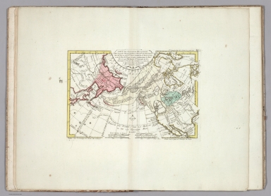
Author
Buache, Philippe, 1700-1773
Full Title
Carte marine des parties septentrionales de la Grande Mer, et de l'ocean : ou l'on a rʹeuni diverses vues phisiques, et ou l'on voit particulierement les terreins inclinʹes vers chaque mer, et dont les eaux s'y dʹechargent depuis les Chaines de Montagnes. dresseʹe et presentee a l'Acad. des Sc. le 9. Aoust 1752 par Phil. Buache. (to accompany) Considerations physique. (inset) Pole Arctique.
List No
11780.009
Note
Engraved colored in outline map of the northern Canada, Alaska and Arctic region Map of the northern Canada, Alaska and Arctic region showing glaciers, oceans and sea currents. and sea currents. Above neat line at right: VIIe. Carte pour la 3e. Partie des considerations &c. Page 142. Includes notes. Relief shown by hachures.
Author
Buache, Philippe, 1700-1773
Full Title
Carte physique des terreins les plus eleves de la partie occidentale du Canada ... Dressee par Philippe Buache, Delahaye L'Aine, sculpsit. Reduction de la carte tracee par le Sauvage Ochagach ... Publiee sous le Privilege de l'Academie des Sciences, du 4 Septembre 1754. Delahaye l'Aine sculpsit. (to accompany) Considerations physique.
List No
11780.010
Note
Engraved colored in outline map of two separate depictions of the interior of the North American continent and Pacific Northwest. Showing trace the river routes from Hudson’s Bay and Lakes Huron, Michigan and Superior in the Northeast, to the apocryphal “Mer de l’ouest” in the unexplored American West. Buache’s depictions for this map were gathered from indigenous native sources as well as from manuscript material drawn by early French explorers and fur traders. In fact, the title of the upper depiction states that the information was garnered by Ochagach, a North American native, which was then given to French officers. At head of map "Reduction de la carte tracee par le Sauvage Ochagach et autres, laquelle a donné lieu aux découvertes des officiers Francais representees dans la carte cy jointe." Above neat line at right: VIIIe. Carte pour la 3e et derniere Partie des considerations &c. Page 146. Includes notes. Relief shown pictorially.
Author
Buache, Philippe, 1700-1773
Full Title
La Californie d'apres une tres grande carte espagnole M.ste de l'Amerique, dressee Sous le Privilege de l'Acade. des Sc. du 24 Juill. 1754. Delahaye l'Aine sculps. Partie de la Californie tiree de l'Amerique Sept.le publiee en 1700 par Guillaume Delisle. Carte du Passage pour Terre a la Californie, decouvert en 1701 par le R. P. Kino Jesuite Avec les Nlles Missions des P. P. de la Compagnie donnee en 1705 dans le tome 5 des Lettres edifiantes. A Paris, sur le Quay de l'Horloge. Sous le Privilege de l'Acade. des Sc. du 24 Juill. 1754. Delahaye l'Aine sculpsit. (to accompany) Considerations physique.
List No
11780.011
Note
3 engraved colored in outline maps on 1 sheet. Showing the changes for the mapping of the Baja California peninsula. California according to Mathieu Neron Peccïolen appears to the left of the sheet (scale 1:20,000); California according to Father Kino, the Jesuit missionary, is given to the right of the sheet (scale 1:6,000,000); part of California according to Guillaume De L'Isle (scale not given, but degrees of latitude shown) is given at the upper centre of the sheet. Kino's map definitively ended the myth of California as an Island. Kino was a jesuit Missionary, who surmised that California was not an island long before his trip to Mexico. When he arrived, he initially transmitted information back to Europe which found its way into Scherer's maps and De Fer's Cette Carte. After obtaining permission to travel up the Gulf of California and explore the region, Kino was able to establish his theory that California was not an island. The first edition of the map was printed in one of the volumes of the Jesuit reports Lettres Edifantes. It was reissued in a number of editions and languages thereafter, and is one of the landmark California maps, although a number of cartographers ignored the report for 20-30 years and continued to show California as an island. Above neat line at right: IX.e Carte pour la 3.e derniere Partie des Considerations. &c Page 71. Includes notes. Relief shown pictorially.
Author
Buache, Philippe, 1700-1773
Full Title
Carte de l'isle de Ieso et de ses environs pour servir a concilier les differentes idees que l'on en a eues jusqu'a present. Dressee par Philippe Bauche ... 1754. Delahaye l'Aine sculpsit. (insets) Extrait de la Carte de l'Histre. de Kaempfer. (with) Extrait donne par Scheuchzer. (with) Parte oriental de Asia. (to accompany) Considerations physique.
List No
11780.012
Note
Engraved outline hand color map of the Isle of Ieso and its surroundings, Northeast Asia. Includes text and note :"Extrait de la carte originale manuscrite de Texeira ou l'on voit de détroit d'Anian qui ne se trouve point sur celle q[u]e Thevenot a publiée en 1664." Above neat line at right: Xe. Carte pour la 3.e Partie des Considerations etc. Page 75. Includes notes. Relief shown pictorially.
Author
Buache, Philippe, 1700-1773
Full Title
Carte du Royaume et des isles de Lieou-Kieou, reduite d'apres les cartes manuscrites que le R.P. Gaubil a dressees en Chine le 6 novembre 1752. Dressee par Phil. Bauche et publiee sous le Privilege de l'Acade. des Sc. du 4 Septembre 1754. (to accompany) Considerations physique.
List No
11780.013
Note
Engraved outline hand color map of East China Sea, Taiwan, Ryukyu Islands, and Kyushu. Relief shown pictorially. Depth shown by soundings. Above neat line at right: XIe. Carte pour la 3.e Partie des Considerations etc. Page 132. Includes notes and compass rose.
Author
Buache, Philippe, 1700-1773
Full Title
Vues des cotes de la terre ou Isle d'ESO de celle de la compagnie et des etats Dessinees sur les Lieux en 1643. par les Hollandois du Viaaseau le Kastrikum lors de leur expedition pour la découverte au Nord du Japon ... Ouvrage publie par Phil. Bauche depuis le 2, Sept. 1752. Jisqu'au 4. Septbre. 1754. A Paris, Sur le Quay de l'Horloge du Palais ou se trouvent les Cartes de l'Atlas Geographique de Guill. Delisle P.er Geographe de Roy, et de Phil. Buache. de l'acad.e des Sciences. (to accompany) Considerations physique.
List No
11780.014
Note
Engraved hand color map of the Baye de Bonne Esperance and 5 coastal profiles of Japan and Russia. Relief shown pictorially. Above neat line at right: XII.e Carte ou Vues pour la Considerations. &c Planche I. Includes notes and compass rose.
Author
Buache, Philippe, 1700-1773
Full Title
Fin de la cote Meridionale d'Eso ... Autre Vue de ces cotes ... Autre Vue ... Isle Valvisch (ou des Baleines) ... Vue du Cap Canal. Vue de la Terre et de l'Isle des Etats ... (to accompany) Considerations physique.
List No
11780.015
Note
Engraved hand color view of 7 coastal profiles of Hokkaido and the Kuril Islands, Japan and Russia. Relief shown pictorially. Above neat line at right: Planche 13e.
Author
Buache, Philippe, 1700-1773
Full Title
Vue de la partie Meridionale de l'Isle des Etats ... Cap de Uries ... Vue de la Pointe Orientale de l'Isle des Etats ... Autre vue ... (to accompany) Considerations physique.
List No
11780.016
Note
Engraved hand color view of 7 coastal profiles of Hokkaido and the Kuril Islands, Japan and Russia. Relief shown pictorially. Above neat line at right: Planche 14e.
Author
Buache, Philippe, 1700-1773
Full Title
Vue de la partie Sept;e. de l'Isle des Etats et de la Terre d'Eso ... Autre vue de l'Isle des Etats ... Vue de la partie Septle. le d'Eso ... Plan de la Cote entre le Pic Antoine et l'isle des Etats. (to accompany) Considerations physique.
List No
11780.017
Note
Engraved hand color 1 map and 5 coastal profiles of Hokkaido and the Kuril Islands, Japan and Russia. Relief shown pictorially. Includes compass rose. Above neat line at right: Planche 15e.
Author
Buache, Philippe, 1700-1773
Full Title
Cote de la partie Septentrionale et Orientle. de la Terre d'Eso. Vue de la Terres de la Compagnie. (to accompany) Considerations physique.
List No
11780.018
Note
Engraved hand color 1 view and 5 coastal profiles of Hokkaido and the Kuril Islands, Japan and Russia. Relief shown pictorially. Includes compass rose. Above neat line at right: Planche 16e.
Author
Buache, Philippe, 1700-1773
Full Title
(Text Page to) Considerations physique. (Publication title) Considerations Geographiques Et Physiques Sur Les Nouvelles Decouvertes Au Nord de La Grande Mer Appellee Vulgairement La Mer Du Sud; avec des cartes, qui y sont relatives ... . par M. Phillipe Bauche. Paris 1753. Publiee sous le privilege de l'Acad. des Sciences. A Paris sur quay de l'Horloge de Palais.
List No
11780.019
Note
Atlas of the physical geography. In two volumes; the first comprising a textual description of recent discoveries in the northern part of the North Pacific Ocean, This is the second volume, part 3, including 16 double page plates, 12 maps and 4 cross sections. Covers: Arctic regions, North pacific Ocean, Pacific Coast ( North America) Japan, Siberia (Russia). Bound in marbled half leather covers with title in gilt on spine. Map are hand colored copper plate engraving dated 1852-1854. Some maps engraved by Jean-Baptiste-Henri Delahaye. Showing political and administrative boundaries, major cities, towns, ports, rivers, canals and mountains. Philippe Buache was a French geographer. He was trained under the geographer Guillaume Delisle, whom he succeeded in the Academie des sciences in 1730. Buache was nominated first geographer of the king in 1729. He established the division of the world by seas and river systems. From Christies auction description of the Martin Greene copy of this atlas (including the text volume): "The first edition of the magnum opus of eighteenth-century Pacific Northwest geography, in the most desired state with maps separately bound in atlas format. This work brings together significant reports concerning the geography of the Pacific Northwest, including the Russian explorations of coastal Alaska, into a coherent cartographic project. Issued over the course of three years, complete sets are extremely rare. Buache, who married into the Delisle family of cartographers, has been overshadowed somewhat in historical estimation by the Delisles on the one hand, and his successor d’Anville on the other. But Buache was not only highly esteemed by his contemporaries, he was considerably ahead of his time in his approach to cartography. A pioneer of what is now called thematic mapping, he created unusual charts which mapped the tremors of the earth, undersea mountain ranges, and the ocean floor of the English channel. Following his uncle-in-law Joseph-Nicolas Delisle, Buache became a proponent of the existence of the Great Western Sea described in the apocryphal letter of Admiral Bartholomew de Fonte. Despite occasional errors, his maps nevertheless contributed greatly to the history of geography—providing here one of the earliest depictions of the Alaskan peninsula, as well as important new details about Louisiana.
Author
Buache, Philippe, 1700-1773
Full Title
(Text Page to (cont.)) Considerations physique. (Publication title) Considerations Geographiques Et Physiques Sur Les Nouvelles Decouvertes Au Nord de La Grande Mer Appellee Vulgairement La Mer Du Sud; avec des cartes, qui y sont relatives ... . par M. Phillipe Bauche. Paris 1753. Publiee sous le privilege de l'Acad. des Sciences. A Paris sur quay de l'Horloge de Palais.
List No
11780.020
Note
Atlas of the physical geography. In two volumes; the first comprising a textual description of recent discoveries in the northern part of the North Pacific Ocean, This is the second volume, part 3, including 16 double page plates, 12 maps and 4 cross sections. Covers: Arctic regions, North pacific Ocean, Pacific Coast ( North America) Japan, Siberia (Russia). Bound in marbled half leather covers with title in gilt on spine. Map are hand colored copper plate engraving dated 1852-1854. Some maps engraved by Jean-Baptiste-Henri Delahaye. Showing political and administrative boundaries, major cities, towns, ports, rivers, canals and mountains. Philippe Buache was a French geographer. He was trained under the geographer Guillaume Delisle, whom he succeeded in the Academie des sciences in 1730. Buache was nominated first geographer of the king in 1729. He established the division of the world by seas and river systems. From Christies auction description of the Martin Greene copy of this atlas (including the text volume): "The first edition of the magnum opus of eighteenth-century Pacific Northwest geography, in the most desired state with maps separately bound in atlas format. This work brings together significant reports concerning the geography of the Pacific Northwest, including the Russian explorations of coastal Alaska, into a coherent cartographic project. Issued over the course of three years, complete sets are extremely rare. Buache, who married into the Delisle family of cartographers, has been overshadowed somewhat in historical estimation by the Delisles on the one hand, and his successor d’Anville on the other. But Buache was not only highly esteemed by his contemporaries, he was considerably ahead of his time in his approach to cartography. A pioneer of what is now called thematic mapping, he created unusual charts which mapped the tremors of the earth, undersea mountain ranges, and the ocean floor of the English channel. Following his uncle-in-law Joseph-Nicolas Delisle, Buache became a proponent of the existence of the Great Western Sea described in the apocryphal letter of Admiral Bartholomew de Fonte. Despite occasional errors, his maps nevertheless contributed greatly to the history of geography—providing here one of the earliest depictions of the Alaskan peninsula, as well as important new details about Louisiana.
Author
Buache, Philippe, 1700-1773
Full Title
(Text Page to) Considerations physique. (Publication title) Considerations Geographiques Et Physiques Sur Les Nouvelles Decouvertes Au Nord de La Grande Mer Appellee Vulgairement La Mer Du Sud; avec des cartes, qui y sont relatives ... . par M. Phillipe Bauche. Paris 1753. Publiee sous le privilege de l'Acad. des Sciences. A Paris sur quay de l'Horloge de Palais.
List No
11780.021
Note
Atlas of the physical geography. In two volumes; the first comprising a textual description of recent discoveries in the northern part of the North Pacific Ocean, This is the second volume, part 3, including 16 double page plates, 12 maps and 4 cross sections. Covers: Arctic regions, North pacific Ocean, Pacific Coast ( North America) Japan, Siberia (Russia). Bound in marbled half leather covers with title in gilt on spine. Map are hand colored copper plate engraving dated 1852-1854. Some maps engraved by Jean-Baptiste-Henri Delahaye. Showing political and administrative boundaries, major cities, towns, ports, rivers, canals and mountains. Philippe Buache was a French geographer. He was trained under the geographer Guillaume Delisle, whom he succeeded in the Academie des sciences in 1730. Buache was nominated first geographer of the king in 1729. He established the division of the world by seas and river systems. From Christies auction description of the Martin Greene copy of this atlas (including the text volume): "The first edition of the magnum opus of eighteenth-century Pacific Northwest geography, in the most desired state with maps separately bound in atlas format. This work brings together significant reports concerning the geography of the Pacific Northwest, including the Russian explorations of coastal Alaska, into a coherent cartographic project. Issued over the course of three years, complete sets are extremely rare. Buache, who married into the Delisle family of cartographers, has been overshadowed somewhat in historical estimation by the Delisles on the one hand, and his successor d’Anville on the other. But Buache was not only highly esteemed by his contemporaries, he was considerably ahead of his time in his approach to cartography. A pioneer of what is now called thematic mapping, he created unusual charts which mapped the tremors of the earth, undersea mountain ranges, and the ocean floor of the English channel. Following his uncle-in-law Joseph-Nicolas Delisle, Buache became a proponent of the existence of the Great Western Sea described in the apocryphal letter of Admiral Bartholomew de Fonte. Despite occasional errors, his maps nevertheless contributed greatly to the history of geography—providing here one of the earliest depictions of the Alaskan peninsula, as well as important new details about Louisiana.
Author
Homann, Johann Baptist, 1663-1724
Full Title
Schematismus Geographiae Mathematicae.
List No
12138.003
Author
[Mount, John, Page, Thomas, 1704-1762, Mount and Page]
Full Title
(Text Page to) The English pilot for the Southern navigation : describing the sea-coasts, capes, headlands, bays, roads, harbours, rivers and ports : together with the soundings, sands, rocks and dangers on the coast of England, Scotland, Ireland, Holland, Flanders, Spain, Portugal, to the Streight's-Mouth, with the coasts of Barbary, and off to the Canary, Madeira, Cape de Verde and Western-Islands : shewing the courses and distances from one place to another, the setting of the tides and currents, the ebbing and flowing of the sea, &c. London : Printed for J. Mount and T. Page, on Tower Hill. M,DCC,LII (1752).
List No
13251.004
Note
Ownership inscription.
Author
[Euler, Leonhard, Sauerbrey, Nicolaus Friedrich, Rhode, Johann Christoph]
Full Title
(Covers to) Atlas geographicus omnes orbis terrarum regiones in XLI tabulis exhibens : jussu Academiae regiae scient. et eleg. litt. Boruss. ad emendatiora, quae adhuc prodiere exempla descriptus atque ad usum potissimum scholarum et institutionem juventutis editus = Atlas geographique representant en XLI cartes toutes les regions de la terre : grave�� par ordre de l'Acade��mie royale des sciences et belles lettres de Prusse d'apres les meilleurs exemplaires qui ayent paru jusqu'icy a l'usage principalement des ecoles. Berolini : Ex officina Michaelis MDCCLIII (1753).
List No
11392.001
Note
First edition of the Atlas by the famous mathematician Leonhard Euler. The Atlas was published on behalf of the Royal Prussian Academy of Sciences in Berlin by Leonhard Euler, designed specifically for the use in schools. The maps were largely based on works of Johann Christoph Rhode and were mostly engraved by Nicolaus Friedrich Sauerbrey. This edition includes a title page, a 10-page preface by Leonhard Euler in Latin and French, 41 double-page engraved maps, plus 4 additional maps. Highlights are 4 maps of the world (one in two sheets) and the 4-sheet map of America. Each map is outline hand colored and has a stamp of the Royal Prussian Academy of Sciences, most maps include decorative title cartouche, showing political and administrative divisions, cities, villages, place names, rivers, canals and mountains. Relief shown pictorially. Bound in brown leather covers with "Atlas geographicus Berolinensis" in gilt on the spine.
Author
[Euler, Leonhard, Sauerbrey, Nicolaus Friedrich, Rhode, Johann Christoph]
Full Title
(Title Page to) Atlas geographicus omnes orbis terrarum regiones in XLI tabulis exhibens : jussu Academiae regiae scient. et eleg. litt. Boruss. ad emendatiora, quae adhuc prodiere exempla descriptus atque ad usum potissimum scholarum et institutionem juventutis editus = Atlas geographique representant en XLI cartes toutes les regions de la terre : grave�� par ordre de l'Acade��mie royale des sciences et belles lettres de Prusse d'apres les meilleurs exemplaires qui ayent paru jusqu'icy a l'usage principalement des ecoles. Berolini : Ex officina Michaelis MDCCLIII (1753).
List No
11392.002
Note
First edition of the Atlas by the famous mathematician Leonhard Euler. The Atlas was published on behalf of the Royal Prussian Academy of Sciences in Berlin by Leonhard Euler, designed specifically for the use in schools. The maps were largely based on works of Johann Christoph Rhode and were mostly engraved by Nicolaus Friedrich Sauerbrey. This edition includes a title page, a 10-page preface by Leonhard Euler in Latin and French, 41 double-page engraved maps, plus 4 additional maps. Highlights are 4 maps of the world (one in two sheets) and the 4-sheet map of America. Each map is outline hand colored and has a stamp of the Royal Prussian Academy of Sciences, most maps include decorative title cartouche, showing political and administrative divisions, cities, villages, place names, rivers, canals and mountains. Relief shown pictorially. Bound in brown leather covers with "Atlas geographicus Berolinensis" in gilt on the spine.
Author
[Euler, Leonhard, Sauerbrey, Nicolaus Friedrich, Rhode, Johann Christoph]
Full Title
(Text Page to) Praeftio=Preface: Atlas geographicus omnes orbis terrarum regiones in XLI tabulis exhibens : jussu Academiae regiae scient. et eleg. litt. Boruss. ad emendatiora, quae adhuc prodiere exempla descriptus atque ad usum potissimum scholarum et institutionem juventutis editus = Atlas geographique representant en XLI cartes toutes les regions de la terre : grave�� par ordre de l'Acade��mie royale des sciences et belles lettres de Prusse d'apres les meilleurs exemplaires qui ayent paru jusqu'icy a l'usage principalement des ecoles. Berolini : Ex officina Michaelis MDCCLIII (1753)..
List No
11392.003
Note
First edition of the Atlas by the famous mathematician Leonhard Euler. The Atlas was published on behalf of the Royal Prussian Academy of Sciences in Berlin by Leonhard Euler, designed specifically for the use in schools. The maps were largely based on works of Johann Christoph Rhode and were mostly engraved by Nicolaus Friedrich Sauerbrey. This edition includes a title page, a 10-page preface by Leonhard Euler in Latin and French, 41 double-page engraved maps, plus 4 additional maps. Highlights are 4 maps of the world (one in two sheets) and the 4-sheet map of America. Each map is outline hand colored and has a stamp of the Royal Prussian Academy of Sciences, most maps include decorative title cartouche, showing political and administrative divisions, cities, villages, place names, rivers, canals and mountains. Relief shown pictorially. Bound in brown leather covers with "Atlas geographicus Berolinensis" in gilt on the spine.
Author
[Euler, Leonhard, Sauerbrey, Nicolaus Friedrich, Rhode, Johann Christoph]
Full Title
(Text Page to) Praeftio=Preface: Atlas geographicus omnes orbis terrarum regiones in XLI tabulis exhibens : jussu Academiae regiae scient. et eleg. litt. Boruss. ad emendatiora, quae adhuc prodiere exempla descriptus atque ad usum potissimum scholarum et institutionem juventutis editus = Atlas geographique representant en XLI cartes toutes les regions de la terre : grave�� par ordre de l'Acade��mie royale des sciences et belles lettres de Prusse d'apres les meilleurs exemplaires qui ayent paru jusqu'icy a l'usage principalement des ecoles. Berolini : Ex officina Michaelis MDCCLIII (1753).
List No
11392.004
Note
First edition of the Atlas by the famous mathematician Leonhard Euler. The Atlas was published on behalf of the Royal Prussian Academy of Sciences in Berlin by Leonhard Euler, designed specifically for the use in schools. The maps were largely based on works of Johann Christoph Rhode and were mostly engraved by Nicolaus Friedrich Sauerbrey. This edition includes a title page, a 10-page preface by Leonhard Euler in Latin and French, 41 double-page engraved maps, plus 4 additional maps. Highlights are 4 maps of the world (one in two sheets) and the 4-sheet map of America. Each map is outline hand colored and has a stamp of the Royal Prussian Academy of Sciences, most maps include decorative title cartouche, showing political and administrative divisions, cities, villages, place names, rivers, canals and mountains. Relief shown pictorially. Bound in brown leather covers with "Atlas geographicus Berolinensis" in gilt on the spine.
Author
[Euler, Leonhard, Sauerbrey, Nicolaus Friedrich, Rhode, Johann Christoph]
Full Title
(Text Page to) Praeftio=Preface: Atlas geographicus omnes orbis terrarum regiones in XLI tabulis exhibens : jussu Academiae regiae scient. et eleg. litt. Boruss. ad emendatiora, quae adhuc prodiere exempla descriptus atque ad usum potissimum scholarum et institutionem juventutis editus = Atlas geographique representant en XLI cartes toutes les regions de la terre : grave�� par ordre de l'Acade��mie royale des sciences et belles lettres de Prusse d'apres les meilleurs exemplaires qui ayent paru jusqu'icy a l'usage principalement des ecoles. Berolini : Ex officina Michaelis MDCCLIII (1753).
List No
11392.005
Note
First edition of the Atlas by the famous mathematician Leonhard Euler. The Atlas was published on behalf of the Royal Prussian Academy of Sciences in Berlin by Leonhard Euler, designed specifically for the use in schools. The maps were largely based on works of Johann Christoph Rhode and were mostly engraved by Nicolaus Friedrich Sauerbrey. This edition includes a title page, a 10-page preface by Leonhard Euler in Latin and French, 41 double-page engraved maps, plus 4 additional maps. Highlights are 4 maps of the world (one in two sheets) and the 4-sheet map of America. Each map is outline hand colored and has a stamp of the Royal Prussian Academy of Sciences, most maps include decorative title cartouche, showing political and administrative divisions, cities, villages, place names, rivers, canals and mountains. Relief shown pictorially. Bound in brown leather covers with "Atlas geographicus Berolinensis" in gilt on the spine.
Author
[Euler, Leonhard, Sauerbrey, Nicolaus Friedrich, Rhode, Johann Christoph]
Full Title
(Text Page to) Praeftio=Preface: Atlas geographicus omnes orbis terrarum regiones in XLI tabulis exhibens : jussu Academiae regiae scient. et eleg. litt. Boruss. ad emendatiora, quae adhuc prodiere exempla descriptus atque ad usum potissimum scholarum et institutionem juventutis editus = Atlas geographique representant en XLI cartes toutes les regions de la terre : grave�� par ordre de l'Acade��mie royale des sciences et belles lettres de Prusse d'apres les meilleurs exemplaires qui ayent paru jusqu'icy a l'usage principalement des ecoles. Berolini : Ex officina Michaelis MDCCLIII (1753).
List No
11392.006
Note
First edition of the Atlas by the famous mathematician Leonhard Euler. The Atlas was published on behalf of the Royal Prussian Academy of Sciences in Berlin by Leonhard Euler, designed specifically for the use in schools. The maps were largely based on works of Johann Christoph Rhode and were mostly engraved by Nicolaus Friedrich Sauerbrey. This edition includes a title page, a 10-page preface by Leonhard Euler in Latin and French, 41 double-page engraved maps, plus 4 additional maps. Highlights are 4 maps of the world (one in two sheets) and the 4-sheet map of America. Each map is outline hand colored and has a stamp of the Royal Prussian Academy of Sciences, most maps include decorative title cartouche, showing political and administrative divisions, cities, villages, place names, rivers, canals and mountains. Relief shown pictorially. Bound in brown leather covers with "Atlas geographicus Berolinensis" in gilt on the spine.
Author
[Euler, Leonhard, Sauerbrey, Nicolaus Friedrich, Rhode, Johann Christoph]
Full Title
(Text Page to) Praeftio=Preface: Atlas geographicus omnes orbis terrarum regiones in XLI tabulis exhibens : jussu Academiae regiae scient. et eleg. litt. Boruss. ad emendatiora, quae adhuc prodiere exempla descriptus atque ad usum potissimum scholarum et institutionem juventutis editus = Atlas geographique representant en XLI cartes toutes les regions de la terre : grave�� par ordre de l'Acade��mie royale des sciences et belles lettres de Prusse d'apres les meilleurs exemplaires qui ayent paru jusqu'icy a l'usage principalement des ecoles. Berolini : Ex officina Michaelis MDCCLIII (1753).
List No
11392.007
Note
First edition of the Atlas by the famous mathematician Leonhard Euler. The Atlas was published on behalf of the Royal Prussian Academy of Sciences in Berlin by Leonhard Euler, designed specifically for the use in schools. The maps were largely based on works of Johann Christoph Rhode and were mostly engraved by Nicolaus Friedrich Sauerbrey. This edition includes a title page, a 10-page preface by Leonhard Euler in Latin and French, 41 double-page engraved maps, plus 4 additional maps. Highlights are 4 maps of the world (one in two sheets) and the 4-sheet map of America. Each map is outline hand colored and has a stamp of the Royal Prussian Academy of Sciences, most maps include decorative title cartouche, showing political and administrative divisions, cities, villages, place names, rivers, canals and mountains. Relief shown pictorially. Bound in brown leather covers with "Atlas geographicus Berolinensis" in gilt on the spine.
Author
[Euler, Leonhard, Sauerbrey, Nicolaus Friedrich, Rhode, Johann Christoph]
Full Title
(Text Page to) Praeftio=Preface: Atlas geographicus omnes orbis terrarum regiones in XLI tabulis exhibens : jussu Academiae regiae scient. et eleg. litt. Boruss. ad emendatiora, quae adhuc prodiere exempla descriptus atque ad usum potissimum scholarum et institutionem juventutis editus = Atlas geographique representant en XLI cartes toutes les regions de la terre : grave�� par ordre de l'Acade��mie royale des sciences et belles lettres de Prusse d'apres les meilleurs exemplaires qui ayent paru jusqu'icy a l'usage principalement des ecoles. Berolini : Ex officina Michaelis MDCCLIII (1753).
List No
11392.008
Note
First edition of the Atlas by the famous mathematician Leonhard Euler. The Atlas was published on behalf of the Royal Prussian Academy of Sciences in Berlin by Leonhard Euler, designed specifically for the use in schools. The maps were largely based on works of Johann Christoph Rhode and were mostly engraved by Nicolaus Friedrich Sauerbrey. This edition includes a title page, a 10-page preface by Leonhard Euler in Latin and French, 41 double-page engraved maps, plus 4 additional maps. Highlights are 4 maps of the world (one in two sheets) and the 4-sheet map of America. Each map is outline hand colored and has a stamp of the Royal Prussian Academy of Sciences, most maps include decorative title cartouche, showing political and administrative divisions, cities, villages, place names, rivers, canals and mountains. Relief shown pictorially. Bound in brown leather covers with "Atlas geographicus Berolinensis" in gilt on the spine.
Author
[Euler, Leonhard, 1707-1783, Sauerbrey, Nicolaus Friedrich, Rhode, Johann Christoph]
Full Title
Mappa Geographica Utriusque Terrae. Hemisphaerii ad emendatiora exempla adhuc edita jusfu Acad Regiae Scient et Eleg Litt Borus-Sicae desoripta. (to accompany) Atlas geographicus omnes orbis terrarum regiones = Atlas geographique representant en XLI cartes toutes les regions de la terre ... Berolini : Ex officina Michaelis MDCCLIII (1753).
List No
11392.009
Note
Outline hand colored double hemisphere map of the World on 2 sheets. Showing the ocean currents near the equator. Includes 4 hemisphere insets showing various projections of the earth's surface. Relief shown pictorially. In lower right corner: 19. Globus generalis.
Author
[Euler, Leonhard, 1707-1783, Sauerbrey, Nicolaus Friedrich]
Full Title
Tabula Geographica utriusque Hemisphaerii Terrestris exhibens declinationem acus magneticae pro singulis locis globi terraquei ad A. C. 1744. Iussu Acad: Reg: Scient: et El: Litt: Bor: descripta. N.F. Sauerbrey fecit. (to accompany) Atlas geographicus omnes orbis terrarum regiones = Atlas geographique representant en XLI cartes toutes les regions de la terre ... Berolini : Ex officina Michaelis MDCCLIII (1753).
List No
11392.010
Note
Outline hand colored double hemisphere map of the World on 2 sheets. Showing magnetic declination lines. Relief shown pictorially. Includes descriptive text in lower panel. In lower right corner: 9. Declination der magnet nadel.
Author
[Euler, Leonhard, 1707-1783, Rhode, Johann Christoph]
Full Title
Tabula geographica Hemisphaerii Borealis : ad emendatiora quae adhuc prodierunt exempla, jussu Acad. Reg. Scient. et Eleg. Litt. Boruss. descripta ; I.C. Rhode delin. (to accompany) Atlas geographicus omnes orbis terrarum regiones = Atlas geographique representant en XLI cartes toutes les regions de la terre ... Berolini : Ex officina Michaelis MDCCLIII (1753).
List No
11392.011
Note
Hand colored copperplate engraving map of Northern Hemisphere on 2 sheets. Relief shown pictorially. Shows extensive river system connecting it with the Great Lakes and thus forming a Northwest Passage. In lower right corner: 23. Hemisphaerium Boreale. Prime meridian is Ferro.
Author
[Euler, Leonhard, 1707-1783, Rhode, Johann Christoph]
Full Title
Tabula geographica hemisphaerii Australis : ad emendatiora quae adhuc prodierunt exempla, jussu Acad. Reg. Scient. et Eleg. Litt. Boruss. descripta ; I.C. Rhode delin. (to accompany) Atlas geographicus omnes orbis terrarum regiones = Atlas geographique representant en XLI cartes toutes les regions de la terre ... Berolini : Ex officina Michaelis MDCCLIII (1753).
List No
11392.012
Note
Hand colored copperplate engraving map of Southern Hemisphere on 2 sheets. Relief shown pictorially. Shows Tasmania and New Guinea still joined to Australia, South Africa, South America. In lower right corner: 22. Hemisphaerium Australe. Prime meridian is Ferro.
Author
[Euler, Leonhard, 1707-1783, Rhode, Johann Christoph]
Full Title
Mappa Mundi generalis : ad emendatiora exempla adhuc edita , jussu Acad. Reg. Scient. et Eleg. Litt. Boruss. Descripta ; I.C. Rhode delin. Sauerbrey Sculp. (to accompany) Atlas geographicus omnes orbis terrarum regiones = Atlas geographique representant en XLI cartes toutes les regions de la terre ... Berolini : Ex officina Michaelis MDCCLIII (1753).
List No
11392.013
Note
Hand colored copperplate engraving map on 2 sheets. Shows North America the Northwest coast is blank and a river provides passage between the Great Lakes and the Pacific. Australia and New Zealand are depicted with partially completed coastlines. Relief shown pictorially. Prime meridian is Ferro. Includes two large explanation tables. In lower right corner: 27. Mappa Mundi Generalis.
Author
[Euler, Leonhard, 1707-1783, Rhode, Johann Christoph, Berger]
Full Title
Carte des differentes operations faites pour determiner la figure de la terre. Carte de l'arc du meridien mesure au Perou par les Academiciens de Paris. Carte de l'arc du meridien mesure au Cercle Polaire par les Academiciens de Paris.--Carte de l'arc du meridien mesure en France par Mons. Picard. des. par I.C.R. Grave par Berger a Berlin. (to accompany) Atlas geographicus omnes orbis terrarum regiones = Atlas geographique representant en XLI cartes toutes les regions de la terre ... Berolini : Ex officina Michaelis MDCCLIII (1753).
List No
11392.014
Note
Hand colored copperplate engraving map on 2 sheets. Showing various operations conducted to determine the shape of the Earth. Relief shown pictorially. Includes explanation text. In lower right corner: Von figur der Erde.
Author
Euler, Leonhard, 1707-1783
Full Title
Tab. Geogr. Europae ad emendatiora quoe ad huc prodierunt exempla jussu Acad. Reg Scient eceleg. Litt. Pruss descripta. (to accompany) Atlas geographicus omnes orbis terrarum regiones = Atlas geographique representant en XLI cartes toutes les regions de la terre ... Berolini : Ex officina Michaelis MDCCLIII (1753).
List No
11392.015
Note
Hand colored copperplate engraving map on 2 sheets. Showing mountains, rivers, lakes, geographical and coastal features, political boundaries, cities, and principal towns. Relief shown pictorially. In lower right corner: 11. Europa.
Author
[Euler, Leonhard, 1707-1783, Sauerbrey, Nicolaus Friedrich]
Full Title
Tabula Geographica Europae ad emendatiora exempla adhuc edita jussu Acad. Reg. scient. et litt. eleg. Boruss descripta. (to accompany) Atlas geographicus omnes orbis terrarum regiones = Atlas geographique representant en XLI cartes toutes les regions de la terre ... Berolini : Ex officina Michaelis MDCCLIII (1753).
List No
11392.016
Note
1 map on 4 sheets. In lower right corner: 12. Europa. Hand colored copperplate engraving map on 2 sheets. Covers Northern Europe, Norway, most of Great Britain, Ireland, Iceland, and a long stretch of Greenland's eastern coast. Showing mountains, rivers, lakes, geographical and coastal features, political boundaries, cities, and principal towns. Relief shown pictorially. Prime meridian is Ferro.
Author
[Euler, Leonhard, 1707-1783, Sauerbrey, Nicolaus Friedrich]
Full Title
Tabula Geographica Europae ad emendatiora exempla adhuc edita jussu Acad. Reg. scient. et litt. eleg. Boruss descripta. Sauerbrey sculp. (to accompany) Atlas geographicus omnes orbis terrarum regiones = Atlas geographique representant en XLI cartes toutes les regions de la terre ... Berolini : Ex officina Michaelis MDCCLIII (1753).
List No
11392.017
Note
1 map on 4 sheets. In lower right corner: 13. Europa. Hand colored copperplate engraving map on 2 sheets. Covers Northern Europe. Showing mountains, rivers, lakes, geographical and coastal features, political boundaries, cities, and principal towns. Relief shown pictorially. Prime meridian is Ferro.
Author
[Euler, Leonhard, 1707-1783, Sauerbrey, Nicolaus Friedrich]
Full Title
Tabula Geographica Europae ad emendatiora exempla adhuc edita jussu Acad. Reg. scient. et litt. eleg. Boruss descripta. Sauerbrey sculp. (to accompany) Atlas geographicus omnes orbis terrarum regiones = Atlas geographique representant en XLI cartes toutes les regions de la terre ... Berolini : Ex officina Michaelis MDCCLIII (1753).
List No
11392.018
Note
1 map on 4 sheets. In lower right corner: 14. Europa. Hand colored copperplate engraving map on 2 sheets. Covers Western Europe. Showing mountains, rivers, lakes, geographical and coastal features, political boundaries, cities, and principal towns. Relief shown pictorially. Prime meridian is Ferro.
Author
[Euler, Leonhard, 1707-1783, Sauerbrey, Nicolaus Friedrich]
Full Title
Tabula Geographica Europae ad emendatiora exempla adhuc edita jussu Acad. Reg. scient. et litt. eleg. Boruss descripta. Sauerbrey sculp. (to accompany) Atlas geographicus omnes orbis terrarum regiones = Atlas geographique representant en XLI cartes toutes les regions de la terre ... Berolini : Ex officina Michaelis MDCCLIII (1753).
List No
11392.019
Note
1 map on 4 sheets. In lower right corner: 15. Europa. Hand colored copperplate engraving map on 2 sheets. Covers Southern Europe. Showing mountains, rivers, lakes, geographical and coastal features, political boundaries, cities, and principal towns. Relief shown pictorially. Prime meridian is Ferro.
Author
[Euler, Leonhard, 1707-1783, Sauerbrey, Nicolaus Friedrich]
Full Title
(Composite to) Tabula Geographica Europae ad emendatiora exempla adhuc edita jussu Acad. Reg. scient. et litt. eleg. Boruss descripta. Sauerbrey sculp. (to accompany) Atlas geographicus omnes orbis terrarum regiones = Atlas geographique representant en XLI cartes toutes les regions de la terre ... Berolini : Ex officina Michaelis MDCCLIII (1753).
List No
11392.020
Note
Composite to sheet 12-15 Europa. Hand colored copperplate engraving map on 2 sheets. Covers Eastern Europe to Asia. Showing mountains, rivers, lakes, geographical and coastal features, political boundaries, cities, and principal towns. Relief shown pictorially. Prime meridian is Ferro.
Author
Euler, Leonhard, 1707-1783
Full Title
Tab. Geogr. Hispaniae ad emendatiora exempla adhuc edita jussu Acad. Reg. scient. et eleg. litt. Boruss descripta. Sauerbrey sculp. (to accompany) Atlas geographicus omnes orbis terrarum regiones = Atlas geographique representant en XLI cartes toutes les regions de la terre ... Berolini : Ex officina Michaelis MDCCLIII (1753).
List No
11392.021
Note
Hand colored copperplate engraving map on 2 sheets. Showing mountains, rivers, lakes, geographical and coastal features, political boundaries, cities, and principal towns. Relief shown pictorially. In lower right corner: 38 Spanien u. Portugal.
Author
[Euler, Leonhard, 1707-1783, Claussen, I.C. G.]
Full Title
Tabula geogr: Galliae ad emendatiora que adhuc prodierunt exemple jussu quae adhuc edita jussu Acad. Reg. scient. et eleg. litt. Boruss descripta. I.C.G. Claussen del. (to accompany) Atlas geographicus omnes orbis terrarum regiones = Atlas geographique representant en XLI cartes toutes les regions de la terre ... Berolini : Ex officina Michaelis MDCCLIII (1753).
List No
11392.022
Note
Hand colored copperplate engraving map on 2 sheets. Showing mountains, rivers, lakes, geographical and coastal features, administrative boundaries, cities, and principal towns. Relief shown pictorially. In lower right corner: 17. Franckreich.
Author
[Euler, Leonhard, 1707-1783, Sauerbrey, Nicolaus Friedrich]
Full Title
Tabula geographica Italiae ad emendatiora exampla adhuc edita jussu Acad. Reg. scient. et eleg. litt. Boruss descripta. N.F. Sauerbrey sculpsit Berolin. (to accompany) Atlas geographicus omnes orbis terrarum regiones = Atlas geographique representant en XLI cartes toutes les regions de la terre ... Berolini : Ex officina Michaelis MDCCLIII (1753).
List No
11392.023
Note
Hand colored copperplate engraving map on 2 sheets. Showing mountains, rivers, lakes, geographical and coastal features, administrative boundaries, cities, and principal towns. Relief shown pictorially. In lower right corner: 26 Italien.
Author
Euler, Leonhard, 1707-1783
Full Title
Tabula geograph: Britanniae ad emendatiora exampla adhuc edita jussu Acad. Reg. scient. et eleg. litt. Prussiae descripta. (to accompany) Atlas geographicus omnes orbis terrarum regiones = Atlas geographique representant en XLI cartes toutes les regions de la terre ... Berolini : Ex officina Michaelis MDCCLIII (1753). (inset) Orcades Insvlae.
List No
11392.024
Note
Hand colored copperplate engraving map on 2 sheets. Showing mountains, rivers, lakes, geographical and coastal features, administrative boundaries, cities, and principal towns. Relief shown pictorially. Includes explanation table. In lower right corner: 21 Gross Brittanien.
Author
[Euler, Leonhard, 1707-1783, Sauerbrey, Nicolaus Friedrich]
Full Title
Tabula geographica Angliae et Walliae ad emendatiora exampla adhuc edita jussu Acad. Reg. scient. et eleg. litt. Boruss descripta. Sauerbrey sculp. (to accompany) Atlas geographicus omnes orbis terrarum regiones = Atlas geographique representant en XLI cartes toutes les regions de la terre ... Berolini : Ex officina Michaelis MDCCLIII (1753). (inset) Orcades Insvlae.
List No
11392.025
Note
Hand colored copperplate engraving map on 2 sheets. Showing mountains, rivers, lakes, geographical and coastal features, administrative boundaries, cities, and principal towns. Relief shown pictorially. In lower right corner: 10. Engeland 1 Theil.
Author
Euler, Leonhard, 1707-1783
Full Title
Tabvla geographca Scotia ad emendatiora que adhuc prodierunt exampla jussu ACAD. Reg. Scient. et eleg. litter: descripta. (to accompany) Atlas geographicus omnes orbis terrarum regiones = Atlas geographique representant en XLI cartes toutes les regions de la terre ... Berolini : Ex officina Michaelis MDCCLIII (1753). (inset) Great Britain.
List No
11392.026
Note
Hand colored copperplate engraving map on 2 sheets. Showing mountains, rivers, lakes, geographical and coastal features, administrative boundaries, cities, and principal towns. Relief shown pictorially. In lower right corner: 35. Schottland. 1 T.
Author
Euler, Leonhard, 1707-1783
Full Title
Mappa geographica Regni Hiberniae ad emendatiora que adhuc prodierunt exampla jussu ACAD. Reg. Scient. et eleg. litter: descripta. (to accompany) Atlas geographicus omnes orbis terrarum regiones = Atlas geographique representant en XLI cartes toutes les regions de la terre ... Berolini : Ex officina Michaelis MDCCLIII (1753). (inset) Great Britain.
List No
11392.027
Note
Hand colored copperplate engraving map on 2 sheets. Showing mountains, rivers, lakes, geographical and coastal features, administrative boundaries, cities, and principal towns. Relief shown pictorially. In lower right corner: 25. Irrland. 1 T.
|