Who What Where WhenWHATShow More |
Author
Gorog, Demeter, 1760-1833
Full Title
(Covers to) Magyar atlas, az az, Magyar, horvat es tot orszagok varmegyeji, s szabad keruletei es a hatar-orzo katonasag videkinek kozonseges es kulonos tabalji : kozre botsatotta Gorog = Atlas Hungaricus : seu regnorum Hungariae, Croatiae et Slavoniae comitatuum, privilegiatorum districtuum, et confiniorum generales & practiculares mappae geographicae. Viennae, 1802.
List No
13049.001
Author
Gorog, Demeter, 1760-1833
Full Title
(Title Page to) Magyar atlas, az az, Magyar, horvat es tot orszagok varmegyeji, s szabad keruletei es a hatar-orzo katonasag videkinek kozonseges es kulonos tabalji : kozre botsatotta Gorog = Atlas Hungaricus : seu regnorum Hungariae, Croatiae et Slavoniae comitatuum, privilegiatorum districtuum, et confiniorum generales & practiculares mappae geographicae. Viennae, 1802.
List No
13049.002
Author
Gorog, Demeter, 1760-1833
Full Title
(Text Page to) Magyar atlas, az az, Magyar, horvat es tot orszagok varmegyeji, s szabad keruletei es a hatar-orzo katonasag videkinek kozonseges es kulonos tabalji : kozre botsatotta Gorog = Atlas Hungaricus : seu regnorum Hungariae, Croatiae et Slavoniae comitatuum, privilegiatorum districtuum, et confiniorum generales & practiculares mappae geographicae. Viennae, 1802.
List No
13049.003
Author
Gorog, Demeter, 1760-1833
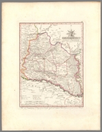
Full Title
Magyar Orszagnak Kozonseges Mappaja ... Karacs metsz Pesten. Nagy Meltosagu Grof Erdody Jozsef ... (to accompany) Magyar atlas ... kozre botsatotta Gorog = Atlas Hungaricus ... Viennae, 1802.
List No
13049.004
Note
Engraved index map of Hungary hand colored in outline. Showing administrative boundaries, cities, towns, rivers, forests and mountains. Relief shown by hachures.
Author
Gorog, Demeter, 1760-1833
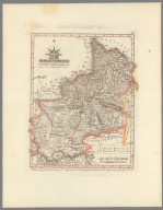
Full Title
Posony Varmegye = (Posoniensis Comitatus). Nagy Meltosagu Grof Palfy Karoly ... (to accompany) Magyar atlas ... kozre botsatotta Gorog = Atlas Hungaricus ... Viennae, 1802.
List No
13049.005
Note
Engraved hand colored in outline map of the Pozsony county was an administrative county, today's Bratislava western Slovakia. Showing administrative boundaries, cities, towns, rivers, forests and mountains. Includes legend and coat of arms. Relief shown by hachures.
Author
Gorog, Demeter, 1760-1833
Full Title
Nyitra Varmegye = Comitatus Nitriensis. (to accompany) Magyar atlas ... kozre botsatotta Gorog = Atlas Hungaricus ... Viennae, 1802.
List No
13049.006
Note
Engraved hand colored in outline map of the Nitra an administrative region of western Slovakia. Showing administrative boundaries, cities, towns, rivers, forests and mountains. Includes legend and coat of arms. Relief shown by hachures.
Author
Gorog, Demeter, 1760-1833
Full Title
Trentsen Varmegye = (Comitatus Trentsiniensis). Nagy Meltosagu Grof Illeshazy Istvan ... B. Biller sculps. (to accompany) Magyar atlas ... kozre botsatotta Gorog = Atlas Hungaricus ... Viennae, 1802.
List No
13049.007
Note
Engraved hand colored in outline map of the Nitra an administrative region of western Slovakia. Showing administrative boundaries, cities, towns, rivers, forests and mountains. Includes legend and coat of arms. Relief shown by hachures.
Author
Gorog, Demeter, 1760-1833
Full Title
Arva Varmegye = (Comitatus Arvensis). Nagy Meltosagu Grof Festetits Gyorgy ... (to accompany) Magyar atlas ... kozre botsatotta Gorog = Atlas Hungaricus ... Viennae, 1802.
List No
13049.008
Note
Engraved hand colored in outline map of the Arva county, Hungary. Showing administrative boundaries, cities, towns, rivers, forests and mountains. Includes legend and coat of arms. Relief shown by hachures.
Author
Gorog, Demeter, 1760-1833
Full Title
Lipto Varmegye = (Comitatus Liptoviensis). per Josephum Hraczky. Nagy Meltosagu Grof Festetits Gyorgy ... Berken Inc. 1801. (to accompany) Magyar atlas ... kozre botsatotta Gorog = Atlas Hungaricus ... Viennae, 1802.
List No
13049.009
Note
Engraved hand colored in outline map of the Lipto county of the Kingdom of Hungary. Showing administrative boundaries, cities, towns, rivers, forests and mountains. Includes legend and coat of arms. Relief shown by hachures.
Author
Gorog, Demeter, 1760-1833
Full Title
Thurotz Varmegye = (Comitatus Thurocziensis). Nagy Meltosagu Grof Festetits Gyorgy ... (to accompany) Magyar atlas ... kozre botsatotta Gorog = Atlas Hungaricus ... Viennae, 1802.
List No
13049.010
Note
Engraved hand colored in outline map. Showing administrative boundaries, cities, towns, rivers, forests and mountains. Includes legend and coat of arms. Relief shown by hachures.
Author
Gorog, Demeter, 1760-1833
Full Title
Bars Varmegye = (Comitatus Barsensis). Nagy Meltosagu Grof Festetits Gyorgy ... (to accompany) Magyar atlas ... kozre botsatotta Gorog = Atlas Hungaricus ... Viennae, 1802.
List No
13049.011
Note
Engraved hand colored in outline map. Showing administrative boundaries, cities, towns, rivers, forests and mountains. Includes legend and coat of arms. Relief shown by hachures.
Author
Gorog, Demeter, 1760-1833
Full Title
Esztergom Varmegye = (Comitatus Strigoniensis). Per Georgium Jaczyg, Ord. Geometram 1805. Hieron. Benedicti sculp. Nehai ... Kardinalis Hertzeg. Primas Battyani Josef ... (to accompany) Magyar atlas ... kozre botsatotta Gorog = Atlas Hungaricus ... Viennae, 1802.
List No
13049.012
Note
Engraved hand colored in outline map of the Esztergom county, Hungary. Showing administrative boundaries, cities, towns, rivers, forests and mountains. Includes legend and coat of arms. Relief shown by hachures.
Author
Gorog, Demeter, 1760-1833
Full Title
Hont Varmegye = Comitatus Honthensis. Meltosagu Grof Festetits Gyorgy ... sc. Nagy. (to accompany) Magyar atlas ... kozre botsatotta Gorog = Atlas Hungaricus ... Viennae, 1802.
List No
13049.013
Note
Engraved hand colored in outline map of the Hont, Hungary. Showing administrative boundaries, cities, towns, rivers, forests and mountains. Includes legend and coat of arms. Relief shown by hachures.
Author
Gorog, Demeter, 1760-1833
Full Title
Zolyom Varmegye = (Comitatus Zoliensis). Meltosagu Grof Festetits Gyorgy ... (to accompany) Magyar atlas ... kozre botsatotta Gorog = Atlas Hungaricus ... Viennae, 1802.
List No
13049.014
Note
Engraved hand colored in outline map of the Zolyom an administrative county of the Kingdom of Hungary now in central Slovakia. Showing administrative boundaries, cities, towns, rivers, forests and mountains. Includes legend and coat of arms. Relief shown by hachures.
Author
Gorog, Demeter, 1760-1833
Full Title
Nograd Varmegye = (Comitatus Neogradiensis). Meltosagu Grof Festetits Gyorgy ... (to accompany) Magyar atlas ... kozre botsatotta Gorog = Atlas Hungaricus ... Viennae, 1802.
List No
13049.015
Note
Engraved hand colored in outline map of the Nograd, Hungary. Showing administrative boundaries, cities, towns, rivers, forests and mountains. Includes legend and coat of arms. Relief shown by hachures.
Author
Gorog, Demeter, 1760-1833
Full Title
Pest, Pilis es Solt torvenyesen egyesult Varmegyek. A'Jaszag, A'Nagy es A'Kis-Kunsag = (Comitatus Pest, Pilis & Solt) ... Luxta mappam maiorem Ant. Balla. Incidit J. Berken Vienna 1796. Meltosagu Grof Festetits Gyorgy ... (to accompany) Magyar atlas ... kozre botsatotta Gorog = Atlas Hungaricus ... Viennae, 1802.
List No
13049.016
Note
Engraved hand colored in outline map of the Pest-Pilis-Solt-Kiskun, Hungary. Showing administrative boundaries, cities, towns, rivers, forests and mountains. Includes legend and coat of arms. Relief shown by hachures.
Author
Gorog, Demeter, 1760-1833
Full Title
Bacs es Bodrogh torvenyesen egyesult Varmegyek = (Comitatus Bacsiensi et Bodrogiensis) ... Articulariter uniti per Anton. Quits. Mettzette H. Benedicti. Meltosagu Urmenyi, Jozef ... (to accompany) Magyar atlas ... kozre botsatotta Gorog = Atlas Hungaricus ... Viennae, 1802.
List No
13049.017
Note
Engraved hand colored in outline map of the Bacs-Bodrog County, Hungary. Showing administrative boundaries, cities, towns, rivers, forests and mountains. Includes legend and coat of arms. Relief shown by hachures.
Author
Gorog, Demeter, 1760-1833
Full Title
Moson Varmegye = (Comitatus Mosoniensis). Luxta correctam Mappam Joan. Kovats. Reduxit M. Votesky. Incidit J. Berken Viennae 1790. Meltosagu Grof. Festetits Gyorgy ... (to accompany) Magyar atlas ... kozre botsatotta Gorog = Atlas Hungaricus ... Viennae, 1802.
List No
13049.018
Note
Engraved hand colored in outline map of the Moson County, Hungary. Showing administrative boundaries, cities, towns, rivers, forests and mountains. Includes legend and coat of arms. Relief shown by hachures.
Author
Gorog, Demeter, 1760-1833
Full Title
Sopron Varmegye = (Comitatus Soproniensis). Luxta delineat. J. Nep. Hegedus. Reduxit M. Votesky. H. Benedicti sc. Meltosagu Grof. Festetits Gyorgy ... (to accompany) Magyar atlas ... kozre botsatotta Gorog = Atlas Hungaricus ... Viennae, 1802.
List No
13049.019
Note
Engraved hand colored in outline map of the Sopron County, Hungary. Showing administrative boundaries, cities, towns, rivers, forests and mountains. Includes legend and coat of arms. Relief shown by hachures.
Author
Gorog, Demeter, 1760-1833
Full Title
Vas Varmegye = (Comitatus Castriferrei). Per Jos. Kenedics. Mettzette Benedicti. Meltosagu Grof. Festetits Gyorgy ... (to accompany) Magyar atlas ... kozre botsatotta Gorog = Atlas Hungaricus ... Viennae, 1802.
List No
13049.020
Note
Engraved hand colored in outline map of the Vas County, Hungary. Showing administrative boundaries, cities, towns, rivers, forests and mountains. Includes legend and coat of arms. Relief shown by hachures.
Author
Gorog, Demeter, 1760-1833
Full Title
Szala Varmegye = (Comitatus Szaladiensis). Luxta Del. Joan Tomasich. H. Benedicti sc. Reduxit M. Votesky. Meltosagu Grof. Festetits Gyorgy ... (to accompany) Magyar atlas ... kozre botsatotta Gorog = Atlas Hungaricus ... Viennae, 1802.
List No
13049.021
Note
Engraved hand colored in outline map of the Zala County, Hungary. Showing administrative boundaries, cities, towns, rivers, forests and mountains. Includes legend and coat of arms. Relief shown by hachures.
Author
Gorog, Demeter, 1760-1833
Full Title
Veszprem Varmegye = (Comitatus Veszprimiensis). Luxta mappam majorem Joannis Gerlich. J. Winter Reduxit. Mettzette Berken Betsben 1799. Meltosagu Grof. Festetits Gyorgy ... (to accompany) Magyar atlas ... kozre botsatotta Gorog = Atlas Hungaricus ... Viennae, 1802.
List No
13049.022
Note
Engraved hand colored in outline map of the Veszprem County, Hungary. Showing administrative boundaries, cities, towns, rivers, forests and mountains. Includes legend and coat of arms. Relief shown by hachures.
Author
Gorog, Demeter, 1760-1833
Full Title
Gyor Varmegye = (Comitatus Jaurinensis). Per Georgium Kiraly. J. Winter Red. a Berken incidit 1804. Meltosagu Grof. Festetits Gyorgy ... (to accompany) Magyar atlas ... kozre botsatotta Gorog = Atlas Hungaricus ... Viennae, 1802.
List No
13049.023
Note
Engraved hand colored in outline map of the Gyor County, Hungary. Showing administrative boundaries, cities, towns, rivers, forests and mountains. Includes legend and coat of arms. Relief shown by hachures.
Author
Gorog, Demeter, 1760-1833
Full Title
Komarom Varmegye = (Comitatus Comaromiensis). A. Benedict sc. Meltosagu Grof. Festetits Gyorgy ... (to accompany) Magyar atlas ... kozre botsatotta Gorog = Atlas Hungaricus ... Viennae, 1802.
List No
13049.024
Note
Engraved hand colored in outline map of the Komarom County, Hungary. Showing administrative boundaries, cities, towns, rivers, forests and mountains. Includes legend and coat of arms. Relief shown by hachures.
Author
Gorog, Demeter, 1760-1833
Full Title
Fejer Varmegye = (Comitatus Albensis). Per Beniaminum Chiapo. H. Benedicti sc. Reduxit M. Voteksy. Meltosagu Grof. Festetits Gyorgy ... (to accompany) Magyar atlas ... kozre botsatotta Gorog = Atlas Hungaricus ... Viennae, 1802.
List No
13049.025
Note
Engraved hand colored in outline map of the Fejer County, Hungary. Showing administrative boundaries, cities, towns, rivers, forests and mountains. Includes legend and coat of arms. Relief shown by hachures.
Author
Gorog, Demeter, 1760-1833
Full Title
Tolna Varmegye = (Comitatus Tolnensis). Luxta Delineat Josephi Schnemann. J. Berken incidit Vienna 1800. Meltosagu Grof. Festetits Gyorgy ... (to accompany) Magyar atlas ... kozre botsatotta Gorog = Atlas Hungaricus ... Viennae, 1802.
List No
13049.026
Note
Engraved hand colored in outline map of the Tolna County, Hungary. Showing administrative boundaries, cities, towns, rivers, forests and mountains. Includes legend and coat of arms. Relief shown by hachures.
Author
Gorog, Demeter, 1760-1833
Full Title
Somogy Varmegye = (Comitatus Sumeghiensis). Reduxit M. Votesky. Mettzette Berken Janos 1793. Meltosagu Grof. Festetits Gyorgy ... (to accompany) Magyar atlas ... kozre botsatotta Gorog = Atlas Hungaricus ... Viennae, 1802.
List No
13049.027
Note
Engraved hand colored in outline map of the Somogy County, Hungary. Showing administrative boundaries, cities, towns, rivers, forests and mountains. Includes legend and coat of arms. Relief shown by hachures.
Author
Gorog, Demeter, 1760-1833
Full Title
Baranya Varmegye = (Comitatus Baranyensis). Reduxit M. Votesky. Mettzette Berken. Meltosagu Grof. Festetits Gyorgy ... (to accompany) Magyar atlas ... kozre botsatotta Gorog = Atlas Hungaricus ... Viennae, 1802.
List No
13049.028
Note
Engraved hand colored in outline map of the Baranya County, Hungary. Showing administrative boundaries, cities, towns, rivers, forests and mountains. Includes legend and coat of arms. Relief shown by hachures.
Author
Gorog, Demeter, 1760-1833
Full Title
Szepes Varmegye = (Comitatus Scepusiensis). B. Biller sculps. Nagy Meltosagu Grof. Festetits Gyorgy ... (to accompany) Magyar atlas ... kozre botsatotta Gorog = Atlas Hungaricus ... Viennae, 1802.
List No
13049.029
Note
Engraved hand colored in outline map of the Szepes County, Hungary. Showing administrative boundaries, cities, towns, rivers, forests and mountains. Includes legend and coat of arms. Relief shown by hachures.
Author
Gorog, Demeter, 1760-1833
Full Title
Saros Varmegye = (Comitatus Sarosiensis). Per Vincent. Beor. C. Agneton re. a Berken sculps. Meltosagu Grof. Festetits Gyorgy ... (to accompany) Magyar atlas ... kozre botsatotta Gorog = Atlas Hungaricus ... Viennae, 1802.
List No
13049.030
Note
Engraved hand colored in outline map of the Saros was an administrative county in Hungary, now in northeastern Slovakia. Showing administrative boundaries, cities, towns, rivers, forests and mountains. Includes legend and coat of arms. Relief shown by hachures.
Author
Gorog, Demeter, 1760-1833
Full Title
Zemplen Varmegye = (Comitatus Zempleniensis). Delin. per Mich. Richter Dorogini. H. Benedicti sc. Meltosagu Grof. Festetits Gyorgy ... (to accompany) Magyar atlas ... kozre botsatotta Gorog = Atlas Hungaricus ... Viennae, 1802.
List No
13049.031
Note
Engraved hand colored in outline map of Zemplen county, Hungary. Showing administrative boundaries, cities, towns, rivers, forests and mountains. Includes legend and coat of arms. Relief shown by hachures.
Author
Gorog, Demeter, 1760-1833
Full Title
Ungvar Varmegye = (Comitatus Ungvariensis). H. Benedicti sc. 1806. Meltosagu Grof. Festetits Gyorgy ... (to accompany) Magyar atlas ... kozre botsatotta Gorog = Atlas Hungaricus ... Viennae, 1802.
List No
13049.032
Note
Engraved hand colored in outline map of Ung county of the Kingdom of Hungary, is now in eastern Slovakia. Showing administrative boundaries, cities, towns, rivers, forests and mountains. Includes legend, table and coat of arms. Relief shown by hachures.
Author
Gorog, Demeter, 1760-1833
Full Title
Beregh Varmegye = (Comitatus Bereghiensis). Luxta Del. J. Buclin. Reduxit M. Votesky. Sc. H. Benedicti. Meltosagu Grof. Festetits Gyorgy ... (to accompany) Magyar atlas ... kozre botsatotta Gorog = Atlas Hungaricus ... Viennae, 1802.
List No
13049.033
Note
Engraved hand colored in outline map of Bereg county of the Kingdom of Hungary. Showing administrative boundaries, cities, towns, rivers, forests and mountains. Includes legend and coat of arms. Relief shown by hachures.
Author
Gorog, Demeter, 1760-1833
Full Title
Abauj Varmegye = (Comitatus Abaujvariensis). J. Winter red. H. Benedicti sc. Meltosagu Grof. Festetits Gyorgy ... (to accompany) Magyar atlas ... kozre botsatotta Gorog = Atlas Hungaricus ... Viennae, 1802.
List No
13049.034
Note
Engraved hand colored in outline map of Abauj county of the Kingdom of Hungary, is now in eastern Slovakia and north-eastern Hungary. Showing administrative boundaries, cities, towns, rivers, forests and mountains. Includes legend and coat of arms. Relief shown by hachures.
Author
Gorog, Demeter, 1760-1833
Full Title
Torna Varmegye = (Comitatus Tornensis). Correcta per Gabr. Szalaky. C. Agneton red. H. Benedicti sc. dir. Meltosagu Grof. Festetits Gyorgy ... (to accompany) Magyar atlas ... kozre botsatotta Gorog = Atlas Hungaricus ... Viennae, 1802.
List No
13049.035
Note
Engraved hand colored in outline map of Torna county of the Kingdom of Hungary, is now in Slovakia. Showing administrative boundaries, cities, towns, rivers, forests and mountains. Includes legend and coat of arms. Relief shown by hachures.
Author
Gorog, Demeter, 1760-1833
Full Title
Gomor Varmegye es a'vele torvenyesen egyesult Kis-Honti Kerulet = (Comitatus Gomoriensis). Opera Christ. Raisz. Sc. H. Benedicti. (to accompany) Magyar atlas ... kozre botsatotta Gorog = Atlas Hungaricus ... Viennae, 1802.
List No
13049.036
Note
Engraved hand colored in outline map of Gomor-Kishont county of the Kingdom of Hungary is now in southern Slovakia. Showing administrative boundaries, cities, towns, rivers, forests and mountains. Includes legend and coat of arms. Relief shown by hachures.
Author
Gorog, Demeter, 1760-1833
Full Title
Borsod Varmegye = (Comitatus Borsodiensis). B. Biller sculps. Nagy Meltosagu Grof. Festetits Gyorgy ... (to accompany) Magyar atlas ... kozre botsatotta Gorog = Atlas Hungaricus ... Viennae, 1802.
List No
13049.037
Note
Engraved hand colored in outline map of Borsod county of the Kingdom of Hungary. Showing administrative boundaries, cities, towns, rivers, forests and mountains. Includes legend and coat of arms. Relief shown by hachures.
Author
Gorog, Demeter, 1760-1833
Full Title
Heves es Kulso-Szolnok torvegyesult Varmegyek = (Comitatus Hevesiensis et Szolnokiensis Exterior, articulariter uniti). Per Joann. Bapt. Litzner. Voteski Mihaly rajzolta. Berken mettzette. Meltosagu Grof. Festetits Gyorgy ... (to accompany) Magyar atlas ... kozre botsatotta Gorog = Atlas Hungaricus ... Viennae, 1802.
List No
13049.038
Note
Engraved hand colored in outline map of Heves county of the Kingdom of Hungary. Showing administrative boundaries, cities, towns, rivers, forests and mountains. Includes legend and coat of arms. Relief shown by hachures.
Author
Gorog, Demeter, 1760-1833
Full Title
Csongrad Varmegye = (Comitatus Csongradiensis). Per Josephum Vertics. J. Winter reduxit. Berken incidit. Meltosagu Grof. Festetits Gyorgy ... (to accompany) Magyar atlas ... kozre botsatotta Gorog = Atlas Hungaricus ... Viennae, 1802.
List No
13049.039
Note
Engraved hand colored in outline map of Csongrad county of the Kingdom of Hungary. Showing administrative boundaries, cities, towns, rivers, forests and mountains. Includes legend and coat of arms. Relief shown by hachures.
Author
Gorog, Demeter, 1760-1833
Full Title
Maramaros Varmegye = (Comitatus Maramarosiensis). Luxta delineat. Sam Billek. Reduxit M. Votesky. H. Benedict sc. Meltosagu Grof. Festetits Gyorgy ... (to accompany) Magyar atlas ... kozre botsatotta Gorog = Atlas Hungaricus ... Viennae, 1802.
List No
13049.040
Note
Engraved hand colored in outline map of Maramaros county of the Kingdom of Hungary. Showing administrative boundaries, cities, towns, rivers, forests and mountains. Includes legend and coat of arms. Relief shown by hachures.
Author
Gorog, Demeter, 1760-1833
Full Title
Ugotsa Varmegye = (Comitatus Ugotsensis). Luxta del. Joan. Hankus. Reduxit M. Votesky. Mettzette H. Benedicti. Meltosagu Grof. Festetits Gyorgy ... (to accompany) Magyar atlas ... kozre botsatotta Gorog = Atlas Hungaricus ... Viennae, 1802.
List No
13049.041
Note
Engraved hand colored in outline map of Ugocsa county of the Kingdom of Hungary. Showing administrative boundaries, cities, towns, rivers, forests and mountains. Includes legend and coat of arms. Relief shown by hachures.
Author
Gorog, Demeter, 1760-1833
Full Title
Szathmar Varmegye = (Comitatus Szathmariensis). Per Cyril Mezeo, et Ant. Zanathy. Reduxit M. Votesky. H. Benedicti sc. Meltosagu Grof. Karolyi Josef ... (to accompany) Magyar atlas ... kozre botsatotta Gorog = Atlas Hungaricus ... Viennae, 1802.
List No
13049.042
Note
Engraved hand colored in outline map of Szatmar county of the Kingdom of Hungary. Showing administrative boundaries, cities, towns, rivers, forests and mountains. Includes legend and coat of arms. Relief shown by hachures.
Author
Gorog, Demeter, 1760-1833
Full Title
Szabolcs Varmegye es AHajdu Varoskkerulete = (Comitatus Szabolcsensis ...) Luxta mappam maiorem Andre. Sexti. J. Winter erduxit a. 1802. H. Benedicti sc. (to accompany) Magyar atlas ... kozre botsatotta Gorog = Atlas Hungaricus ... Viennae, 1802.
List No
13049.043
Note
Engraved hand colored in outline map of Szabolcs county of the Kingdom of Hungary. Showing administrative boundaries, cities, towns, rivers, forests and mountains. Includes legend and coat of arms. Relief shown by hachures.
Author
Gorog, Demeter, 1760-1833
Full Title
Bihar Varmegye = (Comitatus Bihariensis) Luxta Del. Laur. Gaszner. Mettzette Benedicti. Meltosagu Martonfi Josef ... (to accompany) Magyar atlsa ... kozre botsatotta Gorog = Atlas Hungaricus ... Viennae, 1802.
List No
13049.044
Note
Engraved hand colored in outline map of Bihar county of the Kingdom of Hungary. Showing administrative boundaries, cities, towns, rivers, forests and mountains. Includes legend and coat of arms. Relief shown by hachures.
Author
Gorog, Demeter, 1760-1833
Full Title
Bekes Varmegye = (Comitatus Bekesiensis) Per Josephum Vertics. Winter reduxit. Berken incidit. Meltosagu Grof. Festetits Gyorgy ... (to accompany) Magyar atlas ... kozre botsatotta Gorog = Atlas Hungaricus ... Viennae, 1802.
List No
13049.045
Note
Engraved hand colored in outline map of Bekes county of the Kingdom of Hungary. Showing administrative boundaries, cities, towns, rivers, forests and mountains. Includes legend and coat of arms. Relief shown by hachures.
Author
Gorog, Demeter, 1760-1833
Full Title
Arad Varmegye = (Comitatus Aradiensiss). Meltosagu Grof. Festetits Gyorgy ... (to accompany) Magyar atlas ... kozre botsatotta Gorog = Atlas Hungaricus ... Viennae, 1802.
List No
13049.046
Note
Engraved hand colored in outline map of Arad county of the Kingdom of Hungary. Showing administrative boundaries, cities, towns, rivers, forests and mountains. Includes legend and coat of arms. Relief shown by hachures.
Author
Gorog, Demeter, 1760-1833
Full Title
Csanad Varmegye = (Comitatus Csanadiensis). Per Josephum Vertics. J. Winter red. 1802. Berken incidit. (to accompany) Magyar atlas ... kozre botsatotta Gorog = Atlas Hungaricus ... Viennae, 1802.
List No
13049.047
Note
Engraved hand colored in outline map of Csanad county of the Kingdom of Hungary. Showing administrative boundaries, cities, towns, rivers, forests and mountains. Includes legend and coat of arms. Relief shown by hachures.
Author
Gorog, Demeter, 1760-1833
Full Title
Torontal Varmegye = (Comitatus Torontaliensis). Concinn. a Mich. Votesky. Incidit Berken Vienna 1799. (to accompany) Magyar atlas ... kozre botsatotta Gorog = Atlas Hungaricus ... Viennae, 1802.
List No
13049.048
Note
Engraved hand colored in outline map of Torontal county of the Kingdom of Hungary. Showing administrative boundaries, cities, towns, rivers, forests and mountains. Includes legend and coat of arms. Relief shown by hachures.
Author
Gorog, Demeter, 1760-1833
Full Title
Temes Varmegye = (Comitatus Temesiensis). Per Jacobum Degen. J. Winter red. 1802. Berken incidit. Meltosagos Grof Tolnai Festetits ... (to accompany) Magyar atlas ... kozre botsatotta Gorog = Atlas Hungaricus ... Viennae, 1802.
List No
13049.049
Note
Engraved hand colored in outline map of Temes county of the Kingdom of Hungary, is now in southwestern Romania. Showing administrative boundaries, cities, towns, rivers, forests and mountains. Includes legend and coat of arms. Relief shown by hachures.
Author
Gorog, Demeter, 1760-1833
Full Title
Krasso Varmegye = (Comitatus Krassoviensis). Concinn. a Josepho Bagosi. Incidit Berken 1800. Meltosagos Grof Tolnai Festetits ... (to accompany) Magyar atlas ... kozre botsatotta Gorog = Atlas Hungaricus ... Viennae, 1802.
List No
13049.050
Note
Engraved hand colored in outline map of Krasso Szoreny county of the Kingdom of Hungary. Showing administrative boundaries, cities, towns, rivers, forests and mountains. Includes legend and coat of arms. Relief shown by hachures.
|