|
Author
Jefferys, Thomas
Full Title
South part of St. Domingo, or Hispaniola. By Thos. Jefferys, Geographer to his Majesty. London, printed for Robt. Sayer, Map and Printseller, no. 53 in Fleet Street, as the Act directs, 20 Feby. 1775.
List No
4723.018
Note
Engraved nautical chart showing rhumb lines, shoals, anchorages, currents, etc. Relief shown pictorially; depths by soundings. Sheet BH.12 of "... a complete chart of the West Indies ..."
Author
Smyth, David William
Full Title
A Map of the Province of Upper Canada, describing all the new settlements, townships, &c. with the countries adjacent, from Quebec to Lake Huron. (1st ed.) Compiled, at the request of His Excellency Major General John G. Simcoe, First Lieutenant Governor, by David William Smyth Esqr., Surveyor General. London, published by W. Faden, Geographer to His Majesty and to H.R.H. the Prince of Wales, Charing Cross, April 12th 1800. Accompanied with a topographical Description. Price 10s. & 6d.
List No
2496.000
Note
Smyth was the first Surveyor General of Canada and in 1799 wrote "A Short Topographical Description of His Majesty's Province of Upper Canada, In North America" which was sold with the map. This map is the first edition of the "Smyth Series" which went through 13 separate editions to 1858 (see Farrell, Explorations in the History of Canadian Mapping, pp152-154). Smyth's name was dropped from all editions after 1835. Faden published the map until 1818; Wyld published it after 1831. Longest publishing history of any map of the region (Farrell). See our 1818 and the Wyld 1838 for later versions. See Sabin 85205 for more on Smyth and the map. Map has outline color by hand, is dissected into 16 sections and mounted on linen. Folds into a new gray cloth folding case 23.5x16 with "Upper Canada D.W. Smyth 1800" stamped in gold on the spine. Relief shown by hachures.
Author
[Humboldt, Alexander von, 1769-1859, Bonpland, Aime (1773-1858)]
Full Title
Geographie des Plantes Equinoxiales. Tableau Physique des Andes et Pays voisins, dresse d'apres des observations et des mesures prises sur les lieux depuis le 10(degree) degre de latitude boreale jusquau 10(degree) de latitude australe en 1799, 1800, 1801, 1802 et 1803. Par Alexandre de Humboldt et Aime Bonpland. Esquisse et redige par M. de Humboldt dessine par Schonberger et Turpin a paris en 1805, grave par Bouquet, la lettre par Beauble, imprime par Langlois.
List No
11083.000
Note
Uncolored elevation profile of Equinoctial plants, and geology of Andes Region. Drafted by Humboldt designed by Schonberger and Turpin paris in 1805. Includes 2 tables showing distribution of plants and geology in the area. Shows large number of plant families, genera, and species names corresponding to the vicinity of the equator in America. Relief shown pictorially.
Author
Maclure, William
Full Title
(Title Page to) Observations on the Geology of the United States, explanatory of a Geological Map. By William Maclure. Read January 20th, 1809. (In) Transactions of the American Philosophical Society, Held at Philadelphia, for promoting Useful Knowledge. Volume VI. Published by C. and A. Conrad and Co. Philadelphia. ... Jane Aitken, Printer. 1809.
List No
2749A
Note
1st edition of the first geological map of U.S. A portion of a map of the U.S. by Samuel Lewis is used to make this map. The full sheet of paper was put on a larger plate and pulled, leaving the upper and right side without borders, as issued. Uncut and untrimmed, the map appears here with Maclure's original essay on the geology of the U.S. In 1817 Maclure published an expanded versus of his essay, using the small Melish Map of the U.S. as a base. Maclure was dissatisfied with the Lewis map because of its rendering of the mountains, and an errata slip is attached to the back of p 423 explaining this (and stating that originally it was intended to use a reduction of the Bradley U.S. map). See Marcou 1858 for more discussion of the Lewis map. Maclure did a Paris printing of the article and Map (using a map by Volney as a base) in 1811, in French. The Lewis map is most likely the Map of the U.S. published in the 2nd edition of Carey's American Atlas, 1809 (P-Maps p 876,Walsh). Maclure's map and essay are very rare. There is an inscription on the title page to "Mons. F.A. Michaux-Paris, from his friend..." Map bound into the back of paper covered boards with the title handwritten on the spine. Map in full color by geologic structure.
Author
Maclure, William
Full Title
(Text Page to) Observations on the Geology of the United States, explanatory of a Geological Map. By William Maclure. Read January 20th, 1809. (In) Transactions of the American Philosophical Society, Held at Philadelphia, for promoting Useful Knowledge. Volume VI. Published by C. and A. Conrad and Co. Philadelphia. ... Jane Aitken, Printer. 1809.
List No
2749B
Author
Maclure, William
Full Title
A Map of the United States of America. By Samuel G. Lewis.
List No
2749.001
Author
Tanner, Henry Schenck, 1786-1858
Full Title
A Map of the United States, of America; by H.S. Tanner.
List No
16102.010
Note
This map is tipped in to the atlas after the standard map of the United States.
Author
Melish, John
Full Title
(Northwestern Part only of) Map of the United States with the contiguous British & Spanish Possessions Compiled from the latest & best Authorities by John Melish. Engraved by J. Vallance & H.S. Tanner. Entered ... 16th day of June 1820. Published by James Finlayson Agent Philada. Successor to John Melish, Improved to 1823.
List No
5188.000
Note
This is an unusual survivor - in about 1854 someone cut out the Northwestern one third of John Melish's large Map of the United States (1823 edition) and updated it to show the states, territories and proposed territories of that period, notably Kansas and Nebraska but no Gadsden Purchase, and Shoshone and Dakota (which are usually seen on circa 1858-59 maps). The new boundaries are hand colored with white past down labels for names of states and territories. It might have been used as a school map in the west - we found it in a small town in the California gold country. This portion is dissected into 15 sections mounted on linen with silk edging, and folds down to 23x15.
Author
Tanner, Henry Schenck, 1786-1858
Full Title
(Covers to) A New College Atlas consisting of a series of General Maps of the Various Grand Divisions of the Known World. Adapted to the Course of Geographical Instruction usually pursued in the Colleges and High Schools of the United States. By H.S. Tanner, Author of the New American Atlas, &c. Philadelphia: Published by the Author, No. 177, Chesnut Street. 1826.
List No
12139.001
Note
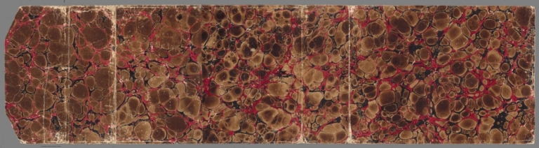
Marbled brownish paper covered boards, quarter bound with reddish leather. Text in faded gilt on spine, "College Atlas".
Author
Tanner, Henry Schenck, 1786-1858
Full Title
(Title Page) A New College Atlas consisting of a series of General Maps of the Various Grand Divisions of the Known World. Adapted to the Course of Geographical Instruction usually pursued in the Colleges and High Schools of the United States. By H.S. Tanner, Author of the New American Atlas, &c. Philadelphia: Published by the Author, No. 177, Chesnut Street. 1826.
List No
12139.002
Author
Tanner, Henry Schenck, 1786-1858
Full Title
The World on Mercators Projection.
List No
12139.003
Author
Tanner, Henry Schenck, 1786-1858
Full Title
Europe.
List No
12139.004
Author
Tanner, Henry Schenck, 1786-1858
Full Title
Asia.
List No
12139.005
Author
Tanner, Henry Schenck, 1786-1858
Full Title
Africa.
List No
12139.006
Author
Tanner, Henry Schenck, 1786-1858
Full Title
America.
List No
12139.007
Author
Tanner, Henry Schenck, 1786-1858
Full Title
North America.
List No
12139.008
Author
Tanner, Henry Schenck, 1786-1858
Full Title
A Map of the United States of America.
List No
12139.009
Author
Tanner, Henry Schenck, 1786-1858
Full Title
(Advertisement) List of Maps, Charts, and Geographical Works Recently Published and for Sale by H.S. Tanner.
List No
12139.010
Author
Tanner, Henry Schenck, 1786-1858
Full Title
(Covers to) Ohio And Indiana. By H.S. Tanner. Engraved & Published by H.S. Tanner, Philadelphia. Entered ... 24th day of May 1819, by Tanner, Vallance, Kearny & Co. ... Pennsylvania.
List No
2939.001
Author
Tanner, Henry Schenck, 1786-1858
Full Title
Ohio And Indiana. By H.S. Tanner. Engraved & Published by H.S. Tanner, Philadelphia. Entered ... 24th day of May 1819, by Tanner, Vallance, Kearny & Co. ... Pennsylvania.
List No
2939.002
Author
[Bonpland, Aime, 1773-1858, Humboldt, Alexander von, 1769-1859, Montufar, Carlos, Vandermaelen, Philippe, 1795-1869]
Full Title
Partie du Mexique. Amer. Sep. no. 70. (with profile) Voyage vers la cime du Chimborazo, tente le 23 Juin 1802, par Alexandre de Humboldt, Aime Bonpland & Carlos Montufar. Esquisse de la geographie des plantes dans les Andes de Quito, entre les 00 20' de lat. bor. & les 40 42' de lat. australe. (Dresse par Ph. Vandermaelen, lithographie par H. Ode. Quatrieme partie. - Amer. sept. Bruxelles. 1827)
List No
2212.276
Note
Hand col. lithographed map. Relief shown by hachures. Covers parts of Guerrero and Oaxaca.
Author
Weiss, Franz von (1791-1858)
Full Title
(Covers to) Carte der Europaeischen Tuerkey nebst einem Theile von Kleinasien in XXI. Blattern. Nach den besten Huelfsquellen entworfen und gezeichnet durch den k.k. Oberstlieutenant Franz von Weiss, herausgegeben von dem k.k. oelster. Generalquartiermeisterstabe Im Jahre 1829.
List No
12291.001
Note
Wrap-around cover with flap, in brown, red and black marbled paper.
Author
Weiss, Franz von (1791-1858)
Full Title
Sheet 1. Carte der Europaeischen Tuerkey nebst einem Theile von Kleinasien in XXI. Blattern. (Legend).
List No
12291.002
Note
A single sheet of this 21-sheet wall map. Includes view of Constantinople.
Author
Weiss, Franz von (1791-1858)
Full Title
Sheet 2. Carte der Europaeischen Tuerkey nebst einem Theile von Kleinasien in XXI. Blattern.
List No
12291.003
Note
A single sheet of this 21-sheet wall map. Includes a list of the sheets.
Author
Weiss, Franz von (1791-1858)
Full Title
Sheet 3. Carte der Europaeischen Tuerkey nebst einem Theile von Kleinasien in XXI. Blattern.
List No
12291.004
Note
A single sheet of this 21-sheet wall map.
Author
Weiss, Franz von (1791-1858)
Full Title
Sheet 4. Carte der Europaeischen Tuerkey nebst einem Theile von Kleinasien in XXI. Blattern.
List No
12291.005
Note
A single sheet of this 21-sheet wall map. This particular sheet has 12 panels.
Author
Weiss, Franz von (1791-1858)
Full Title
Sheet 5. Carte der Europaeischen Tuerkey nebst einem Theile von Kleinasien in XXI. Blattern.
List No
12291.006
Note
A single sheet of this 21-sheet wall map.
Author
Weiss, Franz von (1791-1858)
Full Title
Sheet 6. Carte der Europaeischen Tuerkey nebst einem Theile von Kleinasien in XXI. Blattern.
List No
12291.007
Note
A single sheet of this 21-sheet wall map.
Author
Weiss, Franz von (1791-1858)
Full Title
Sheet 7. Carte der Europaeischen Tuerkey nebst einem Theile von Kleinasien in XXI. Blattern. (inset) Plan von Belgrad.
List No
12291.008
Note
A single sheet of this 21-sheet wall map.
Author
Weiss, Franz von (1791-1858)
Full Title
Sheet 8. Carte der Europaeischen Tuerkey nebst einem Theile von Kleinasien in XXI. Blattern.
List No
12291.009
Note
A single sheet of this 21-sheet wall map.
Author
Weiss, Franz von (1791-1858)
Full Title
Sheet 9. Carte der Europaeischen Tuerkey nebst einem Theile von Kleinasien in XXI. Blattern.
List No
12291.010
Note
A single sheet of this 21-sheet wall map.
Author
Weiss, Franz von (1791-1858)
Full Title
Sheet 10. Carte der Europaeischen Tuerkey nebst einem Theile von Kleinasien in XXI. Blattern.
List No
12291.011
Note
A single sheet of this 21-sheet wall map.
Author
Weiss, Franz von (1791-1858)
Full Title
Sheet 11. Carte der Europaeischen Tuerkey nebst einem Theile von Kleinasien in XXI. Blattern.
List No
12291.012
Note
A single sheet of this 21-sheet wall map.
Author
Weiss, Franz von (1791-1858)
Full Title
Sheet 12. Carte der Europaeischen Tuerkey nebst einem Theile von Kleinasien in XXI. Blattern.
List No
12291.013
Note
A single sheet of this 21-sheet wall map.
Author
Weiss, Franz von (1791-1858)
Full Title
Sheet 13. Carte der Europaeischen Tuerkey nebst einem Theile von Kleinasien in XXI. Blattern. (insets) Plan der Halb-Jusel von Prevesa und der Einfahrt in den Busen von Arta. Cap Antirrhium. Plan des Canals der Dardanellen von Lepanto. Plan des Isthmus von Corinth.
List No
12291.014
Note
A single sheet of this 21-sheet wall map.
Author
Weiss, Franz von (1791-1858)
Full Title
Sheet 14. Carte der Europaeischen Tuerkey nebst einem Theile von Kleinasien in XXI. Blattern.
List No
12291.015
Note
A single sheet of this 21-sheet wall map.
Author
Weiss, Franz von (1791-1858)
Full Title
Sheet 15. Carte der Europaeischen Tuerkey nebst einem Theile von Kleinasien in XXI. Blattern.
List No
12291.016
Note
A single sheet of this 21-sheet wall map.
Author
Weiss, Franz von (1791-1858)
Full Title
Sheet 16. Carte der Europaeischen Tuerkey nebst einem Theile von Kleinasien in XXI. Blattern. (insets) Plan des Hellesponts oder der Dardanellen Strasse. Plan des Bosphorus und der Umgegend von Constantinopel.
List No
12291.017
Note
A single sheet of this 21-sheet wall map.
Author
Weiss, Franz von (1791-1858)
Full Title
Sheet 17. Carte der Europaeischen Tuerkey nebst einem Theile von Kleinasien in XXI. Blattern. (inset) Plan des Hafens von Navarin.
List No
12291.018
Note
A single sheet of this 21-sheet wall map.
Author
Weiss, Franz von (1791-1858)
Full Title
Sheet 18. Carte der Europaeischen Tuerkey nebst einem Theile von Kleinasien in XXI. Blattern. (inset) Plan der Stadt und der Haefen von Rhodes.
List No
12291.019
Note
A single sheet of this 21-sheet wall map.
Author
Weiss, Franz von (1791-1858)
Full Title
Sheet 19. Carte der Europaeischen Tuerkey nebst einem Theile von Kleinasien in XXI. Blattern. (inset) General Carte von Kleinasien.
List No
12291.020
Note
A single sheet of this 21-sheet wall map. This sheet has 12 panels.
Author
Weiss, Franz von (1791-1858)
Full Title
Sheet 20. Carte der Europaeischen Tuerkey nebst einem Theile von Kleinasien in XXI. Blattern. (inset) Statistische Ubersicht der Europaeischen Tuerkey.
List No
12291.021
Note
A single sheet of this 21-sheet wall map.
Author
Weiss, Franz von (1791-1858)
Full Title
Sheet 21. Carte der Europaeischen Tuerkey nebst einem Theile von Kleinasien in XXI. Blattern. (inset) Plan der Stadt und des Hafens von Smyrna.
List No
12291.022
Note
A single sheet of this 21-sheet wall map.
Author
Weiss, Franz von (1791-1858)
Full Title
(Composite Map.) Carte der Europaeischen Tuerkey nebst einem Theile von Kleinasien in XXI. Blattern.
List No
12291.023
Note
A composite map of this 21-sheet wall map.
Author
[Tanner, Henry Schenck, 1786-1858, Melish, John]
Full Title
(Covers to) A Map of Philadelphia County Constructed by virtue of an Act of the Legislature of Pennsylvania
List No
15333.001
Note
The depiction of railroads around Philadelphia is very early and many lines are prospective.
Author
[Tanner, Henry Schenck, 1786-1858, Melish, John]
Full Title
A Map of Philadelphia County Constructed by virtue of an Act of the Legislature of Pennsylvania
List No
15333.002
Note
The depiction of railroads around Philadelphia is very early and many lines are prospective.
Author
Tanner, Henry Schenck, 1786-1858
Full Title
A New And Authentic Map Of The World Embracing All The Recent Discoveries, And Exhibiting Particularly The Nautical Researches Of The Most Distinguished Circumnavigators From The Latest & Best Authorities; With Numerous Corrections & Additions, By H.S. Tanner.
List No
10889.000
Author
Tanner, Henry Schenck, 1786-1858
Full Title
(Henry S. Tanner letter, signed, to Gales & Seaton)
List No
15759.000
Author
Thrall, Willis
Full Title
(Covers to) Map of Ohio compiled from the latest and most authentic information. Hartford, published by Willis Thrall. 1832. Entered ... 12th day of Sept. 1832 by Willis Thrall ... Connecticut.
List No
4907A
Note
Red leather cover 13x8, with "Ohio" and decorative border in gilt.
Author
Thrall, Willis
Full Title
Map of Ohio compiled from the latest and most authentic information. Hartford, published by Willis Thrall. 1832. Entered ... 12th day of Sept. 1832 by Willis Thrall ... Connecticut.
List No
4907.001
Note
First edition. This is a very good map of the state for its period, showing all the town boundaries in the counties, and a lovely "View of Cincinnati" below the title. It is larger than most of the other contemporary pocket maps (Burr, Reed, Mitchell, Tanner) and has better detail. This first edition is not in any references. Folded in 13x9 red leather cover with "Ohio" and decorative border in gilt.
|