|
Author
[Turgot, Michel-Etienne, Bretez, Louis, Lucas, Claude]
Full Title
(Covers to) Paris. Plan de Turgot
List No
10553.001
Note
First edition, published in 1739. Original binding. See our 1860 reissue from the same plates (10059.000). "In 1734 Michel-Etienne Turgot, chief of the municipality of Paris as provost of merchants, decided to promote the reputation of Paris for Parisian, provincial or foreign elites by implementing a new map of the city. He asked Louis Bretez, member of the Royal Academy of Painting and Sculpture and professor of perspective, to draw up the plan of Paris and its suburbs. By contract, Turgot requested a very faithful reproduction with great accuracy. Louis Bretez, was allowed to enter into the mansions, houses and gardens in order to take measurements and draw pictures. He worked for two years (1734-1736). In the eighteenth century, the trend was to abandon portraits of cities (inherited from the Renaissance) for a geometric plan, more technical and mathematical. But the plan de Turgot goes against this trend, by choosing the system of perspective cavaliere: two buildings of the same size are represented by two drawings of the same size, whether the buildings are close or distant. In 1736, Claude Lucas, engraver of the Royal Academy of Sciences, created the 21 sheets of the plan. The plan was published in 1739, and the prints were bound in volumes offered to the King, the members of the Academy, and the Municipality. Additional copies were to serve as representations of France to foreigners. The 21 engraved brass plates are kept by the Chalcography of the Louvre, where they are even now used for re-printing employing the same techniques as two centuries ago." (Wikipedia).
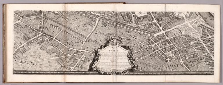
Author
[Turgot, Michel-Etienne, Bretez, Louis, Lucas, Claude]
Full Title
Key Sheet. Paris. Plan de Turgot
List No
10553.002
Note
First edition, published in 1739. Original binding. See our 1860 reissue from the same plates (10059.000). "In 1734 Michel-Etienne Turgot, chief of the municipality of Paris as provost of merchants, decided to promote the reputation of Paris for Parisian, provincial or foreign elites by implementing a new map of the city. He asked Louis Bretez, member of the Royal Academy of Painting and Sculpture and professor of perspective, to draw up the plan of Paris and its suburbs. By contract, Turgot requested a very faithful reproduction with great accuracy. Louis Bretez, was allowed to enter into the mansions, houses and gardens in order to take measurements and draw pictures. He worked for two years (1734-1736). In the eighteenth century, the trend was to abandon portraits of cities (inherited from the Renaissance) for a geometric plan, more technical and mathematical. But the plan de Turgot goes against this trend, by choosing the system of perspective cavaliere: two buildings of the same size are represented by two drawings of the same size, whether the buildings are close or distant. In 1736, Claude Lucas, engraver of the Royal Academy of Sciences, created the 21 sheets of the plan. The plan was published in 1739, and the prints were bound in volumes offered to the King, the members of the Academy, and the Municipality. Additional copies were to serve as representations of France to foreigners. The 21 engraved brass plates are kept by the Chalcography of the Louvre, where they are even now used for re-printing employing the same techniques as two centuries ago." (Wikipedia).
Author
[Turgot, Michel-Etienne, Bretez, Louis, Lucas, Claude]
Full Title
Sheet 1. Paris. Plan de Turgot
List No
10553.003
Note
First edition, published in 1739. Original binding. See our 1860 reissue from the same plates (10059.000). "In 1734 Michel-Etienne Turgot, chief of the municipality of Paris as provost of merchants, decided to promote the reputation of Paris for Parisian, provincial or foreign elites by implementing a new map of the city. He asked Louis Bretez, member of the Royal Academy of Painting and Sculpture and professor of perspective, to draw up the plan of Paris and its suburbs. By contract, Turgot requested a very faithful reproduction with great accuracy. Louis Bretez, was allowed to enter into the mansions, houses and gardens in order to take measurements and draw pictures. He worked for two years (1734-1736). In the eighteenth century, the trend was to abandon portraits of cities (inherited from the Renaissance) for a geometric plan, more technical and mathematical. But the plan de Turgot goes against this trend, by choosing the system of perspective cavaliere: two buildings of the same size are represented by two drawings of the same size, whether the buildings are close or distant. In 1736, Claude Lucas, engraver of the Royal Academy of Sciences, created the 21 sheets of the plan. The plan was published in 1739, and the prints were bound in volumes offered to the King, the members of the Academy, and the Municipality. Additional copies were to serve as representations of France to foreigners. The 21 engraved brass plates are kept by the Chalcography of the Louvre, where they are even now used for re-printing employing the same techniques as two centuries ago." (Wikipedia).
Author
[Turgot, Michel-Etienne, Bretez, Louis, Lucas, Claude]
Full Title
Sheet 2. Paris. Plan de Turgot
List No
10553.004
Note
First edition, published in 1739. Original binding. See our 1860 reissue from the same plates (10059.000). "In 1734 Michel-Etienne Turgot, chief of the municipality of Paris as provost of merchants, decided to promote the reputation of Paris for Parisian, provincial or foreign elites by implementing a new map of the city. He asked Louis Bretez, member of the Royal Academy of Painting and Sculpture and professor of perspective, to draw up the plan of Paris and its suburbs. By contract, Turgot requested a very faithful reproduction with great accuracy. Louis Bretez, was allowed to enter into the mansions, houses and gardens in order to take measurements and draw pictures. He worked for two years (1734-1736). In the eighteenth century, the trend was to abandon portraits of cities (inherited from the Renaissance) for a geometric plan, more technical and mathematical. But the plan de Turgot goes against this trend, by choosing the system of perspective cavaliere: two buildings of the same size are represented by two drawings of the same size, whether the buildings are close or distant. In 1736, Claude Lucas, engraver of the Royal Academy of Sciences, created the 21 sheets of the plan. The plan was published in 1739, and the prints were bound in volumes offered to the King, the members of the Academy, and the Municipality. Additional copies were to serve as representations of France to foreigners. The 21 engraved brass plates are kept by the Chalcography of the Louvre, where they are even now used for re-printing employing the same techniques as two centuries ago." (Wikipedia).
Author
[Turgot, Michel-Etienne, Bretez, Louis, Lucas, Claude]
Full Title
Sheet 3. Paris. Plan de Turgot
List No
10553.005
Note
First edition, published in 1739. Original binding. See our 1860 reissue from the same plates (10059.000). "In 1734 Michel-Etienne Turgot, chief of the municipality of Paris as provost of merchants, decided to promote the reputation of Paris for Parisian, provincial or foreign elites by implementing a new map of the city. He asked Louis Bretez, member of the Royal Academy of Painting and Sculpture and professor of perspective, to draw up the plan of Paris and its suburbs. By contract, Turgot requested a very faithful reproduction with great accuracy. Louis Bretez, was allowed to enter into the mansions, houses and gardens in order to take measurements and draw pictures. He worked for two years (1734-1736). In the eighteenth century, the trend was to abandon portraits of cities (inherited from the Renaissance) for a geometric plan, more technical and mathematical. But the plan de Turgot goes against this trend, by choosing the system of perspective cavaliere: two buildings of the same size are represented by two drawings of the same size, whether the buildings are close or distant. In 1736, Claude Lucas, engraver of the Royal Academy of Sciences, created the 21 sheets of the plan. The plan was published in 1739, and the prints were bound in volumes offered to the King, the members of the Academy, and the Municipality. Additional copies were to serve as representations of France to foreigners. The 21 engraved brass plates are kept by the Chalcography of the Louvre, where they are even now used for re-printing employing the same techniques as two centuries ago." (Wikipedia).
Author
[Turgot, Michel-Etienne, Bretez, Louis, Lucas, Claude]
Full Title
Sheet 4. Paris. Plan de Turgot
List No
10553.006
Note
First edition, published in 1739. Original binding. See our 1860 reissue from the same plates (10059.000). "In 1734 Michel-Etienne Turgot, chief of the municipality of Paris as provost of merchants, decided to promote the reputation of Paris for Parisian, provincial or foreign elites by implementing a new map of the city. He asked Louis Bretez, member of the Royal Academy of Painting and Sculpture and professor of perspective, to draw up the plan of Paris and its suburbs. By contract, Turgot requested a very faithful reproduction with great accuracy. Louis Bretez, was allowed to enter into the mansions, houses and gardens in order to take measurements and draw pictures. He worked for two years (1734-1736). In the eighteenth century, the trend was to abandon portraits of cities (inherited from the Renaissance) for a geometric plan, more technical and mathematical. But the plan de Turgot goes against this trend, by choosing the system of perspective cavaliere: two buildings of the same size are represented by two drawings of the same size, whether the buildings are close or distant. In 1736, Claude Lucas, engraver of the Royal Academy of Sciences, created the 21 sheets of the plan. The plan was published in 1739, and the prints were bound in volumes offered to the King, the members of the Academy, and the Municipality. Additional copies were to serve as representations of France to foreigners. The 21 engraved brass plates are kept by the Chalcography of the Louvre, where they are even now used for re-printing employing the same techniques as two centuries ago." (Wikipedia).
Author
[Turgot, Michel-Etienne, Bretez, Louis, Lucas, Claude]
Full Title
Sheet 5. Paris. Plan de Turgot
List No
10553.007
Note
First edition, published in 1739. Original binding. See our 1860 reissue from the same plates (10059.000). "In 1734 Michel-Etienne Turgot, chief of the municipality of Paris as provost of merchants, decided to promote the reputation of Paris for Parisian, provincial or foreign elites by implementing a new map of the city. He asked Louis Bretez, member of the Royal Academy of Painting and Sculpture and professor of perspective, to draw up the plan of Paris and its suburbs. By contract, Turgot requested a very faithful reproduction with great accuracy. Louis Bretez, was allowed to enter into the mansions, houses and gardens in order to take measurements and draw pictures. He worked for two years (1734-1736). In the eighteenth century, the trend was to abandon portraits of cities (inherited from the Renaissance) for a geometric plan, more technical and mathematical. But the plan de Turgot goes against this trend, by choosing the system of perspective cavaliere: two buildings of the same size are represented by two drawings of the same size, whether the buildings are close or distant. In 1736, Claude Lucas, engraver of the Royal Academy of Sciences, created the 21 sheets of the plan. The plan was published in 1739, and the prints were bound in volumes offered to the King, the members of the Academy, and the Municipality. Additional copies were to serve as representations of France to foreigners. The 21 engraved brass plates are kept by the Chalcography of the Louvre, where they are even now used for re-printing employing the same techniques as two centuries ago." (Wikipedia).
Author
[Turgot, Michel-Etienne, Bretez, Louis, Lucas, Claude]
Full Title
Sheet 6. Paris. Plan de Turgot
List No
10553.008
Note
First edition, published in 1739. Original binding. See our 1860 reissue from the same plates (10059.000). "In 1734 Michel-Etienne Turgot, chief of the municipality of Paris as provost of merchants, decided to promote the reputation of Paris for Parisian, provincial or foreign elites by implementing a new map of the city. He asked Louis Bretez, member of the Royal Academy of Painting and Sculpture and professor of perspective, to draw up the plan of Paris and its suburbs. By contract, Turgot requested a very faithful reproduction with great accuracy. Louis Bretez, was allowed to enter into the mansions, houses and gardens in order to take measurements and draw pictures. He worked for two years (1734-1736). In the eighteenth century, the trend was to abandon portraits of cities (inherited from the Renaissance) for a geometric plan, more technical and mathematical. But the plan de Turgot goes against this trend, by choosing the system of perspective cavaliere: two buildings of the same size are represented by two drawings of the same size, whether the buildings are close or distant. In 1736, Claude Lucas, engraver of the Royal Academy of Sciences, created the 21 sheets of the plan. The plan was published in 1739, and the prints were bound in volumes offered to the King, the members of the Academy, and the Municipality. Additional copies were to serve as representations of France to foreigners. The 21 engraved brass plates are kept by the Chalcography of the Louvre, where they are even now used for re-printing employing the same techniques as two centuries ago." (Wikipedia).
Author
[Turgot, Michel-Etienne, Bretez, Louis, Lucas, Claude]
Full Title
Sheet 7. Paris. Plan de Turgot
List No
10553.009
Note
First edition, published in 1739. Original binding. See our 1860 reissue from the same plates (10059.000). "In 1734 Michel-Etienne Turgot, chief of the municipality of Paris as provost of merchants, decided to promote the reputation of Paris for Parisian, provincial or foreign elites by implementing a new map of the city. He asked Louis Bretez, member of the Royal Academy of Painting and Sculpture and professor of perspective, to draw up the plan of Paris and its suburbs. By contract, Turgot requested a very faithful reproduction with great accuracy. Louis Bretez, was allowed to enter into the mansions, houses and gardens in order to take measurements and draw pictures. He worked for two years (1734-1736). In the eighteenth century, the trend was to abandon portraits of cities (inherited from the Renaissance) for a geometric plan, more technical and mathematical. But the plan de Turgot goes against this trend, by choosing the system of perspective cavaliere: two buildings of the same size are represented by two drawings of the same size, whether the buildings are close or distant. In 1736, Claude Lucas, engraver of the Royal Academy of Sciences, created the 21 sheets of the plan. The plan was published in 1739, and the prints were bound in volumes offered to the King, the members of the Academy, and the Municipality. Additional copies were to serve as representations of France to foreigners. The 21 engraved brass plates are kept by the Chalcography of the Louvre, where they are even now used for re-printing employing the same techniques as two centuries ago." (Wikipedia).
Author
[Turgot, Michel-Etienne, Bretez, Louis, Lucas, Claude]
Full Title
Sheet 8. Paris. Plan de Turgot
List No
10553.010
Note
First edition, published in 1739. Original binding. See our 1860 reissue from the same plates (10059.000). "In 1734 Michel-Etienne Turgot, chief of the municipality of Paris as provost of merchants, decided to promote the reputation of Paris for Parisian, provincial or foreign elites by implementing a new map of the city. He asked Louis Bretez, member of the Royal Academy of Painting and Sculpture and professor of perspective, to draw up the plan of Paris and its suburbs. By contract, Turgot requested a very faithful reproduction with great accuracy. Louis Bretez, was allowed to enter into the mansions, houses and gardens in order to take measurements and draw pictures. He worked for two years (1734-1736). In the eighteenth century, the trend was to abandon portraits of cities (inherited from the Renaissance) for a geometric plan, more technical and mathematical. But the plan de Turgot goes against this trend, by choosing the system of perspective cavaliere: two buildings of the same size are represented by two drawings of the same size, whether the buildings are close or distant. In 1736, Claude Lucas, engraver of the Royal Academy of Sciences, created the 21 sheets of the plan. The plan was published in 1739, and the prints were bound in volumes offered to the King, the members of the Academy, and the Municipality. Additional copies were to serve as representations of France to foreigners. The 21 engraved brass plates are kept by the Chalcography of the Louvre, where they are even now used for re-printing employing the same techniques as two centuries ago." (Wikipedia).
Author
[Turgot, Michel-Etienne, Bretez, Louis, Lucas, Claude]
Full Title
Sheet 9. Paris. Plan de Turgot
List No
10553.011
Note
First edition, published in 1739. Original binding. See our 1860 reissue from the same plates (10059.000). "In 1734 Michel-Etienne Turgot, chief of the municipality of Paris as provost of merchants, decided to promote the reputation of Paris for Parisian, provincial or foreign elites by implementing a new map of the city. He asked Louis Bretez, member of the Royal Academy of Painting and Sculpture and professor of perspective, to draw up the plan of Paris and its suburbs. By contract, Turgot requested a very faithful reproduction with great accuracy. Louis Bretez, was allowed to enter into the mansions, houses and gardens in order to take measurements and draw pictures. He worked for two years (1734-1736). In the eighteenth century, the trend was to abandon portraits of cities (inherited from the Renaissance) for a geometric plan, more technical and mathematical. But the plan de Turgot goes against this trend, by choosing the system of perspective cavaliere: two buildings of the same size are represented by two drawings of the same size, whether the buildings are close or distant. In 1736, Claude Lucas, engraver of the Royal Academy of Sciences, created the 21 sheets of the plan. The plan was published in 1739, and the prints were bound in volumes offered to the King, the members of the Academy, and the Municipality. Additional copies were to serve as representations of France to foreigners. The 21 engraved brass plates are kept by the Chalcography of the Louvre, where they are even now used for re-printing employing the same techniques as two centuries ago." (Wikipedia).
Author
[Turgot, Michel-Etienne, Bretez, Louis, Lucas, Claude]
Full Title
Sheet 10. Paris. Plan de Turgot
List No
10553.012
Note
First edition, published in 1739. Original binding. See our 1860 reissue from the same plates (10059.000). "In 1734 Michel-Etienne Turgot, chief of the municipality of Paris as provost of merchants, decided to promote the reputation of Paris for Parisian, provincial or foreign elites by implementing a new map of the city. He asked Louis Bretez, member of the Royal Academy of Painting and Sculpture and professor of perspective, to draw up the plan of Paris and its suburbs. By contract, Turgot requested a very faithful reproduction with great accuracy. Louis Bretez, was allowed to enter into the mansions, houses and gardens in order to take measurements and draw pictures. He worked for two years (1734-1736). In the eighteenth century, the trend was to abandon portraits of cities (inherited from the Renaissance) for a geometric plan, more technical and mathematical. But the plan de Turgot goes against this trend, by choosing the system of perspective cavaliere: two buildings of the same size are represented by two drawings of the same size, whether the buildings are close or distant. In 1736, Claude Lucas, engraver of the Royal Academy of Sciences, created the 21 sheets of the plan. The plan was published in 1739, and the prints were bound in volumes offered to the King, the members of the Academy, and the Municipality. Additional copies were to serve as representations of France to foreigners. The 21 engraved brass plates are kept by the Chalcography of the Louvre, where they are even now used for re-printing employing the same techniques as two centuries ago." (Wikipedia).
Author
[Turgot, Michel-Etienne, Bretez, Louis, Lucas, Claude]
Full Title
Sheet 11. Paris. Plan de Turgot
List No
10553.013
Note
First edition, published in 1739. Original binding. See our 1860 reissue from the same plates (10059.000). "In 1734 Michel-Etienne Turgot, chief of the municipality of Paris as provost of merchants, decided to promote the reputation of Paris for Parisian, provincial or foreign elites by implementing a new map of the city. He asked Louis Bretez, member of the Royal Academy of Painting and Sculpture and professor of perspective, to draw up the plan of Paris and its suburbs. By contract, Turgot requested a very faithful reproduction with great accuracy. Louis Bretez, was allowed to enter into the mansions, houses and gardens in order to take measurements and draw pictures. He worked for two years (1734-1736). In the eighteenth century, the trend was to abandon portraits of cities (inherited from the Renaissance) for a geometric plan, more technical and mathematical. But the plan de Turgot goes against this trend, by choosing the system of perspective cavaliere: two buildings of the same size are represented by two drawings of the same size, whether the buildings are close or distant. In 1736, Claude Lucas, engraver of the Royal Academy of Sciences, created the 21 sheets of the plan. The plan was published in 1739, and the prints were bound in volumes offered to the King, the members of the Academy, and the Municipality. Additional copies were to serve as representations of France to foreigners. The 21 engraved brass plates are kept by the Chalcography of the Louvre, where they are even now used for re-printing employing the same techniques as two centuries ago." (Wikipedia).
Author
[Turgot, Michel-Etienne, Bretez, Louis, Lucas, Claude]
Full Title
Sheet 12. Paris. Plan de Turgot
List No
10553.014
Note
First edition, published in 1739. Original binding. See our 1860 reissue from the same plates (10059.000). "In 1734 Michel-Etienne Turgot, chief of the municipality of Paris as provost of merchants, decided to promote the reputation of Paris for Parisian, provincial or foreign elites by implementing a new map of the city. He asked Louis Bretez, member of the Royal Academy of Painting and Sculpture and professor of perspective, to draw up the plan of Paris and its suburbs. By contract, Turgot requested a very faithful reproduction with great accuracy. Louis Bretez, was allowed to enter into the mansions, houses and gardens in order to take measurements and draw pictures. He worked for two years (1734-1736). In the eighteenth century, the trend was to abandon portraits of cities (inherited from the Renaissance) for a geometric plan, more technical and mathematical. But the plan de Turgot goes against this trend, by choosing the system of perspective cavaliere: two buildings of the same size are represented by two drawings of the same size, whether the buildings are close or distant. In 1736, Claude Lucas, engraver of the Royal Academy of Sciences, created the 21 sheets of the plan. The plan was published in 1739, and the prints were bound in volumes offered to the King, the members of the Academy, and the Municipality. Additional copies were to serve as representations of France to foreigners. The 21 engraved brass plates are kept by the Chalcography of the Louvre, where they are even now used for re-printing employing the same techniques as two centuries ago." (Wikipedia).
Author
[Turgot, Michel-Etienne, Bretez, Louis, Lucas, Claude]
Full Title
Sheet 13. Paris. Plan de Turgot
List No
10553.015
Note
First edition, published in 1739. Original binding. See our 1860 reissue from the same plates (10059.000). "In 1734 Michel-Etienne Turgot, chief of the municipality of Paris as provost of merchants, decided to promote the reputation of Paris for Parisian, provincial or foreign elites by implementing a new map of the city. He asked Louis Bretez, member of the Royal Academy of Painting and Sculpture and professor of perspective, to draw up the plan of Paris and its suburbs. By contract, Turgot requested a very faithful reproduction with great accuracy. Louis Bretez, was allowed to enter into the mansions, houses and gardens in order to take measurements and draw pictures. He worked for two years (1734-1736). In the eighteenth century, the trend was to abandon portraits of cities (inherited from the Renaissance) for a geometric plan, more technical and mathematical. But the plan de Turgot goes against this trend, by choosing the system of perspective cavaliere: two buildings of the same size are represented by two drawings of the same size, whether the buildings are close or distant. In 1736, Claude Lucas, engraver of the Royal Academy of Sciences, created the 21 sheets of the plan. The plan was published in 1739, and the prints were bound in volumes offered to the King, the members of the Academy, and the Municipality. Additional copies were to serve as representations of France to foreigners. The 21 engraved brass plates are kept by the Chalcography of the Louvre, where they are even now used for re-printing employing the same techniques as two centuries ago." (Wikipedia).
Author
[Turgot, Michel-Etienne, Bretez, Louis, Lucas, Claude]
Full Title
Sheet 14. Paris. Plan de Turgot
List No
10553.016
Note
First edition, published in 1739. Original binding. See our 1860 reissue from the same plates (10059.000). "In 1734 Michel-Etienne Turgot, chief of the municipality of Paris as provost of merchants, decided to promote the reputation of Paris for Parisian, provincial or foreign elites by implementing a new map of the city. He asked Louis Bretez, member of the Royal Academy of Painting and Sculpture and professor of perspective, to draw up the plan of Paris and its suburbs. By contract, Turgot requested a very faithful reproduction with great accuracy. Louis Bretez, was allowed to enter into the mansions, houses and gardens in order to take measurements and draw pictures. He worked for two years (1734-1736). In the eighteenth century, the trend was to abandon portraits of cities (inherited from the Renaissance) for a geometric plan, more technical and mathematical. But the plan de Turgot goes against this trend, by choosing the system of perspective cavaliere: two buildings of the same size are represented by two drawings of the same size, whether the buildings are close or distant. In 1736, Claude Lucas, engraver of the Royal Academy of Sciences, created the 21 sheets of the plan. The plan was published in 1739, and the prints were bound in volumes offered to the King, the members of the Academy, and the Municipality. Additional copies were to serve as representations of France to foreigners. The 21 engraved brass plates are kept by the Chalcography of the Louvre, where they are even now used for re-printing employing the same techniques as two centuries ago." (Wikipedia).
Author
[Turgot, Michel-Etienne, Bretez, Louis, Lucas, Claude]
Full Title
Sheet 15. Paris. Plan de Turgot
List No
10553.017
Note
First edition, published in 1739. Original binding. See our 1860 reissue from the same plates (10059.000). "In 1734 Michel-Etienne Turgot, chief of the municipality of Paris as provost of merchants, decided to promote the reputation of Paris for Parisian, provincial or foreign elites by implementing a new map of the city. He asked Louis Bretez, member of the Royal Academy of Painting and Sculpture and professor of perspective, to draw up the plan of Paris and its suburbs. By contract, Turgot requested a very faithful reproduction with great accuracy. Louis Bretez, was allowed to enter into the mansions, houses and gardens in order to take measurements and draw pictures. He worked for two years (1734-1736). In the eighteenth century, the trend was to abandon portraits of cities (inherited from the Renaissance) for a geometric plan, more technical and mathematical. But the plan de Turgot goes against this trend, by choosing the system of perspective cavaliere: two buildings of the same size are represented by two drawings of the same size, whether the buildings are close or distant. In 1736, Claude Lucas, engraver of the Royal Academy of Sciences, created the 21 sheets of the plan. The plan was published in 1739, and the prints were bound in volumes offered to the King, the members of the Academy, and the Municipality. Additional copies were to serve as representations of France to foreigners. The 21 engraved brass plates are kept by the Chalcography of the Louvre, where they are even now used for re-printing employing the same techniques as two centuries ago." (Wikipedia).
Author
[Turgot, Michel-Etienne, Bretez, Louis, Lucas, Claude]
Full Title
Sheet 16. Paris. Plan de Turgot
List No
10553.018
Note
First edition, published in 1739. Original binding. See our 1860 reissue from the same plates (10059.000). "In 1734 Michel-Etienne Turgot, chief of the municipality of Paris as provost of merchants, decided to promote the reputation of Paris for Parisian, provincial or foreign elites by implementing a new map of the city. He asked Louis Bretez, member of the Royal Academy of Painting and Sculpture and professor of perspective, to draw up the plan of Paris and its suburbs. By contract, Turgot requested a very faithful reproduction with great accuracy. Louis Bretez, was allowed to enter into the mansions, houses and gardens in order to take measurements and draw pictures. He worked for two years (1734-1736). In the eighteenth century, the trend was to abandon portraits of cities (inherited from the Renaissance) for a geometric plan, more technical and mathematical. But the plan de Turgot goes against this trend, by choosing the system of perspective cavaliere: two buildings of the same size are represented by two drawings of the same size, whether the buildings are close or distant. In 1736, Claude Lucas, engraver of the Royal Academy of Sciences, created the 21 sheets of the plan. The plan was published in 1739, and the prints were bound in volumes offered to the King, the members of the Academy, and the Municipality. Additional copies were to serve as representations of France to foreigners. The 21 engraved brass plates are kept by the Chalcography of the Louvre, where they are even now used for re-printing employing the same techniques as two centuries ago." (Wikipedia).
Author
[Turgot, Michel-Etienne, Bretez, Louis, Lucas, Claude]
Full Title
Sheet 17. Paris. Plan de Turgot
List No
10553.019
Note
First edition, published in 1739. Original binding. See our 1860 reissue from the same plates (10059.000). "In 1734 Michel-Etienne Turgot, chief of the municipality of Paris as provost of merchants, decided to promote the reputation of Paris for Parisian, provincial or foreign elites by implementing a new map of the city. He asked Louis Bretez, member of the Royal Academy of Painting and Sculpture and professor of perspective, to draw up the plan of Paris and its suburbs. By contract, Turgot requested a very faithful reproduction with great accuracy. Louis Bretez, was allowed to enter into the mansions, houses and gardens in order to take measurements and draw pictures. He worked for two years (1734-1736). In the eighteenth century, the trend was to abandon portraits of cities (inherited from the Renaissance) for a geometric plan, more technical and mathematical. But the plan de Turgot goes against this trend, by choosing the system of perspective cavaliere: two buildings of the same size are represented by two drawings of the same size, whether the buildings are close or distant. In 1736, Claude Lucas, engraver of the Royal Academy of Sciences, created the 21 sheets of the plan. The plan was published in 1739, and the prints were bound in volumes offered to the King, the members of the Academy, and the Municipality. Additional copies were to serve as representations of France to foreigners. The 21 engraved brass plates are kept by the Chalcography of the Louvre, where they are even now used for re-printing employing the same techniques as two centuries ago." (Wikipedia).
Author
[Turgot, Michel-Etienne, Bretez, Louis, Lucas, Claude]
Full Title
Sheet 18 and 19. Paris. Plan de Turgot
List No
10553.020
Note
First edition, published in 1739. Original binding. See our 1860 reissue from the same plates (10059.000). "In 1734 Michel-Etienne Turgot, chief of the municipality of Paris as provost of merchants, decided to promote the reputation of Paris for Parisian, provincial or foreign elites by implementing a new map of the city. He asked Louis Bretez, member of the Royal Academy of Painting and Sculpture and professor of perspective, to draw up the plan of Paris and its suburbs. By contract, Turgot requested a very faithful reproduction with great accuracy. Louis Bretez, was allowed to enter into the mansions, houses and gardens in order to take measurements and draw pictures. He worked for two years (1734-1736). In the eighteenth century, the trend was to abandon portraits of cities (inherited from the Renaissance) for a geometric plan, more technical and mathematical. But the plan de Turgot goes against this trend, by choosing the system of perspective cavaliere: two buildings of the same size are represented by two drawings of the same size, whether the buildings are close or distant. In 1736, Claude Lucas, engraver of the Royal Academy of Sciences, created the 21 sheets of the plan. The plan was published in 1739, and the prints were bound in volumes offered to the King, the members of the Academy, and the Municipality. Additional copies were to serve as representations of France to foreigners. The 21 engraved brass plates are kept by the Chalcography of the Louvre, where they are even now used for re-printing employing the same techniques as two centuries ago." (Wikipedia).
Author
[Turgot, Michel-Etienne, Bretez, Louis, Lucas, Claude]
Full Title
Sheet 20. Paris. Plan de Turgot
List No
10553.021
Note
First edition, published in 1739. Original binding. See our 1860 reissue from the same plates (10059.000). "In 1734 Michel-Etienne Turgot, chief of the municipality of Paris as provost of merchants, decided to promote the reputation of Paris for Parisian, provincial or foreign elites by implementing a new map of the city. He asked Louis Bretez, member of the Royal Academy of Painting and Sculpture and professor of perspective, to draw up the plan of Paris and its suburbs. By contract, Turgot requested a very faithful reproduction with great accuracy. Louis Bretez, was allowed to enter into the mansions, houses and gardens in order to take measurements and draw pictures. He worked for two years (1734-1736). In the eighteenth century, the trend was to abandon portraits of cities (inherited from the Renaissance) for a geometric plan, more technical and mathematical. But the plan de Turgot goes against this trend, by choosing the system of perspective cavaliere: two buildings of the same size are represented by two drawings of the same size, whether the buildings are close or distant. In 1736, Claude Lucas, engraver of the Royal Academy of Sciences, created the 21 sheets of the plan. The plan was published in 1739, and the prints were bound in volumes offered to the King, the members of the Academy, and the Municipality. Additional copies were to serve as representations of France to foreigners. The 21 engraved brass plates are kept by the Chalcography of the Louvre, where they are even now used for re-printing employing the same techniques as two centuries ago." (Wikipedia).
Author
[Turgot, Michel-Etienne, Bretez, Louis, Lucas, Claude]
Full Title
Composite: Paris. Plan de Turgot
List No
10553.022
Note
First edition, published in 1739. Original binding. See our 1860 reissue from the same plates (10059.000). "In 1734 Michel-Etienne Turgot, chief of the municipality of Paris as provost of merchants, decided to promote the reputation of Paris for Parisian, provincial or foreign elites by implementing a new map of the city. He asked Louis Bretez, member of the Royal Academy of Painting and Sculpture and professor of perspective, to draw up the plan of Paris and its suburbs. By contract, Turgot requested a very faithful reproduction with great accuracy. Louis Bretez, was allowed to enter into the mansions, houses and gardens in order to take measurements and draw pictures. He worked for two years (1734-1736). In the eighteenth century, the trend was to abandon portraits of cities (inherited from the Renaissance) for a geometric plan, more technical and mathematical. But the plan de Turgot goes against this trend, by choosing the system of perspective cavaliere: two buildings of the same size are represented by two drawings of the same size, whether the buildings are close or distant. In 1736, Claude Lucas, engraver of the Royal Academy of Sciences, created the 21 sheets of the plan. The plan was published in 1739, and the prints were bound in volumes offered to the King, the members of the Academy, and the Municipality. Additional copies were to serve as representations of France to foreigners. The 21 engraved brass plates are kept by the Chalcography of the Louvre, where they are even now used for re-printing employing the same techniques as two centuries ago." (Wikipedia).
Author
Lewis, Samuel
Full Title
Connecticut. Drawn by S. Lewis. (Published by John Conrad & Co., Philadelphia. 1804)
List No
2436.041
Note
Engraved map, uncolored. Relief shown by hachures. Prime meridians: Philadelphia and London. "County lines are shown, but not town lines and the towns shown are not complete for this date. In a later edition of the Atlas, May 1812, the same map appears with the slight alternation of having shading removed on the shore line"--Thompson.
Author
[Gaitte,Antoine Joseph, Ledoux, Claude Nicholas]
Full Title
(Covers to) Recueil des plus belles Maisons et des plus belles Edifices de la Ville de Paris Publie par Gaitte.
List No
16163.001
Note
Date estimated.
Author
[Gaitte,Antoine Joseph, Ledoux, Claude Nicholas]
Full Title
(Title page to) Recueil des plus belles Maisons et des plus belles Edifices de la Ville de Paris Publie par Gaitte.
List No
16163.002
Note
Date estimated.
Author
[Gaitte,Antoine Joseph, Ledoux, Claude Nicholas]
Full Title
No 1 Pavillon de Lucienne, Maison de Mlle de St Germain, Maison de M. de Ste Foix, Maison de Mr de Brunois, Comedie Italienne, Maison de la ruw d"Artois, Maison de Mlle Guimard, Comedie Francaise.
List No
16163.003
Note
Date estimated.
Author
[Gaitte,Antoine Joseph, Ledoux, Claude Nicholas]
Full Title
No 2 les Invalides, le Val-de-Grace, Collège de Mazarin, l'Assomption, Ste Genevieve, St Sulpice, St Philippes du Roule, la Capuciniere Chaussee d’Antin
List No
16163.004
Note
Date estimated.
Author
[Gaitte,Antoine Joseph, Ledoux, Claude Nicholas]
Full Title
No 3 Porte St Denis, Porte St Martin, Porte du Palais Bourbon, Porte de l’Hotel d’Uzes, Nouvelle Halle, Facade de l’Opéra, Maison de M. de Monaco, Maison de Mlle de Condé
List No
16163.005
Note
Date estimated.
Author
[Gaitte,Antoine Joseph, Ledoux, Claude Nicholas]
Full Title
No 4 Maison du Prince de Salms, Pompe à l’eau vue du côté de la Rivière, Pompe à l’eau vue du côté de la Porte d'Entrée, Maison près la Pompe à Feu, Maison de M. de Vanne, Ancienne Facade des Eleves de l’Opéra, Maison de M. de Foulon, Hôtel de Montholon
List No
16163.006
Note
Date estimated.
Author
[Gaitte,Antoine Joseph, Ledoux, Claude Nicholas]
Full Title
No 5 Facade de l’Ecole de Chirurgie, Palais de Justice, Facade interieure de l’Ecole de Chirurgie, Observatoire du Cote du Nord, Maison de Mr de Nemours auclos Payen, Observatoire du Cote du Midi
List No
16163.007
Note
Date estimated.
Author
[Gaitte,Antoine Joseph, Ledoux, Claude Nicholas]
Full Title
No 6 Hospice de la Paroisse de St. Jacque St. Philippe, Hospice de M. de Beaujon, Hospice de la Charité Route d'Orleans, Porte de l'Hôpital des Maladies Vénériennes, Chapelle de M. de Beaujon, Portique des Salles de la Charité
List No
16163.008
Note
Date estimated.
Author
[Gaitte,Antoine Joseph, Ledoux, Claude Nicholas]
Full Title
No. 7 Barrière de Fontainebleau, Barrière de l’Ours ine, Barrière St Jacques, Barrière d'Orléans, Barrière du Mont-Parnasse, Barrière du Maine, Barrière de Vanves, Barrière Plumet.
List No
16163.009
Note
Date estimated.
Author
[Gaitte,Antoine Joseph, Ledoux, Claude Nicholas]
Full Title
No 8 Barrière de l’Ecole Militaire, Barrière de Grenelle, Barrière de Sève, Barrière de Versailles, Barrière de Chaillot, Barrière de Chaillot,
List No
16163.010
Note
Date estimated.
Author
[Gaitte,Antoine Joseph, Ledoux, Claude Nicholas]
Full Title
No 9 Barrière du Réservoir, Barrière de l’Etoile, Barrière de Courcelle, Barrière située derrière le Jardin de Mr le Duc d’Orléans, Barrière du Roule, Barrière de Monceau
List No
16163.011
Note
Date estimated.
Author
[Gaitte,Antoine Joseph, Ledoux, Claude Nicholas]
Full Title
No 10 Barrière de Clichy, Barrière Blanche, Barrière de la Rue Royale, Barrière des Martyrs, Barrière St Denis, Barrière des Vertus
List No
16163.012
Note
Date estimated.
Author
[Gaitte,Antoine Joseph, Ledoux, Claude Nicholas]
Full Title
No 11 Barrière de Pantin, Duane, Barrière de la Villette, Barrière St Louis, Barrière de la Basse Courtille, Barrière de la Chopinette
List No
16163.013
Note
Date estimated.
Author
[Gaitte,Antoine Joseph, Ledoux, Claude Nicholas]
Full Title
No 12 Barrière des Deux Couronnes, Barrière de Ménilmontant, Barrière de Fontarabie, Barrière Poissonnière, Barrière des Rats et B. de la Folie Renauld, Barrière des Amandiers
List No
16163.014
Note
Date estimated.
Author
[Gaitte,Antoine Joseph, Ledoux, Claude Nicholas]
Full Title
No 13 Barrière de Montreuil, Barrière de Charenton, Barrière de Bercy, Barrière de la Rapé, 1re. Douane de la Barrière d'Orléans, Barrière de Vaugirard
List No
16163.015
Note
Date estimated.
Author
[Gaitte,Antoine Joseph, Ledoux, Claude Nicholas]
Full Title
No 14 Barrière de Vincennes, Barrière de St Mande, Barrière de Picpus, Barrière de Reuilly
List No
16163.016
Note
Date estimated.
Author
[Gaitte,Antoine Joseph, Ledoux, Claude Nicholas]
Full Title
No 15 Palais de Salins, Barriere d'Ivry, Hotel de Montholon, Douaine de la Bre d'Orleans
List No
16163.017
Note
Date estimated.
Author
[Gaitte,Antoine Joseph, Ledoux, Claude Nicholas]
Full Title
No 16 Vue de la Colonnades du Louvre, Theatre Rue de Lavieloire, Maison Rue St Lazare
List No
16163.018
Note
Date estimated.
Author
[Gaitte,Antoine Joseph, Ledoux, Claude Nicholas]
Full Title
No 17 Palais des Tuileries du cote de la cour, Maison Rue de Provence, Grotte du Jardin du Luxembourg, Maison de Mr de Montmorency Vallee de Montmorency
List No
16163.019
Note
Date estimated.
Author
[Gaitte,Antoine Joseph, Ledoux, Claude Nicholas]
Full Title
No 18 Ecole Militaire, Maison pres Paris, Fontaine des Innocents, Maison Rue St. Lazare.
List No
16163.020
Note
Date estimated.
Author
[Gaitte,Antoine Joseph, Ledoux, Claude Nicholas]
Full Title
No 19 Maison pres Paris, Pavillon de Mousseau, Maison situee pres Paris, Maison Rue du Mont Blanc, Hotel de l'Infantado, Maison pres Paris
List No
16163.021
Note
Date estimated.
Author
[Gaitte,Antoine Joseph, Ledoux, Claude Nicholas]
Full Title
No 20 Chambre des Deputes, Maison Rue N.D. des Champs, Maison Rue M.D. des Champs, Maison Rue de Surene
List No
16163.022
Note
Date estimated.
Author
[Gaitte,Antoine Joseph, Ledoux, Claude Nicholas]
Full Title
No 21 Hotel des Monnoies, Maison Faubourg Poissonniere, Maison Rue de Clichy, Maison Faubourg Saint Honore
List No
16163.023
Note
Date estimated.
Author
[Gaitte,Antoine Joseph, Ledoux, Claude Nicholas]
Full Title
No 22 Maison Rue Ville l'Eueque, Maison pres Paris, Maison Rue de Braque, Hotel de Halwit, Theatre des Varietes, Maison situee aux Champs Elisees
List No
16163.024
Note
Date estimated.
Author
[Gaitte,Antoine Joseph, Ledoux, Claude Nicholas]
Full Title
No 23 Maison Rue des Trois Freres, Timbre Royal, Maison Boulevard du Mont-Parnasse, Maison Rue Pigale, Maison Rue de Mont-Blanc, Maison Chaussee d'Antin
List No
16163.025
Note
Date estimated.
Author
[Gaitte,Antoine Joseph, Ledoux, Claude Nicholas]
Full Title
No 24 Palais du Luxembourg cote de la Rue de Tournon, Maison pres Meudon, Maison pres Paris, Maison Rue Poissonniere
List No
16163.026
Note
Date estimated.
Author
[Gaitte,Antoine Joseph, Ledoux, Claude Nicholas]
Full Title
No 25 Palais du Luxembourg, Fontaine St. Suprice, Fontaine du Regard, Fontine du Gros Cailloic
List No
16163.027
Note
Date estimated.
|