|
Author
Brue, Adrien Hubert, 1786-1832
Full Title
(Western Hemisphere). Dressee et Redigee par A.H. Brue. Publiee en Juin 1820. Augmentee en 7 bre 1821. Gravee sous la direction de l'Auteur. a Londres, chez Cary Md. de Cartes Geog. a Milan, chez Betailli et Compie. a Vienne, chez Artaria Md. d'Estampes ... (embossed seal) Carte Encyprotipe AHB.
List No
2394.000
Note
Untitled map of the the Western Hemisphere, with the North American geography following Lewis and Clark's discoveries. There is an advertisement explaining the author's rational for the choice of locations that are unknown. Map is dissected into 20 sections, and mounted and bordered with linen. With hand painted outline color. End sheet has a label reading "Mappemonde Amerique" in ms, "Magasin de Geographie de Chles. Simonneau Graveur. A Paris, Rue de la Paix No. 6. Hotel Mirabeau, via-a-vis le Timbre..." and dated below that, "le 15-2-1907" in ms; under the label in ms reads "Mappemonde des 2 Ameriques a Moulinard." Map folds into a new brown cloth folding case 26x20 with "Amerique Brue 1821" stamped in gold on the spine.
Author
[France. Commission des sciences et arts d'Egypte, Panckoucke, C. L. F. (Charles Louis Fleury), 1780-1844]
Full Title
(Covers to) Description de l'Egypte ou recueil des observations et des recherches qui ont ete faites en Egypte pendant l'Expedition de l'Armee francaise. Seconde edition. Dediee au Roi. Publiee par C.L.F. Panckoucke, Chevalier de la Legion d'Honneur. Atlas geographique. Paris, Imprimerie de C.L.F. Panckoucke. MDCCCXXVI.
List No
3964A
Note
Half leather marbled paper covered boards, with gold stamped spine title: Description de l'Egypte. Atlas geographique.
Author
[France. Commission des sciences et arts d'Egypte, Panckoucke, C. L. F. (Charles Louis Fleury), 1780-1844]
Full Title
(Title Page to) Description de l'Egypte ou recueil des observations et des recherches qui ont ete faites en Egypte pendant l'Expedition de l'Armee francaise. Seconde edition. Dediee au Roi. Publiee par C.L.F. Panckoucke, Chevalier de la Legion d'Honneur. Atlas geographique. Paris, Imprimerie de C.L.F. Panckoucke. MDCCCXXVI.
List No
3964B
Note
Includes ill.
Author
[Arrowsmith, John, 1790-1873, Franklin, John, 1786-1847, Parry, William Edward, Sir, 1790-1855, M'Clintock, Francis Leopold, Sir, 1819-1907]
Full Title
Sir John Franklin's Arctic discoveries, between Baffin Bay & Cape Bathurst, combined with those of Sir Edward Parry in 1819 and the several searching expeditions, concluding with that of Sir Francis L.M. Clintock in 1859. Constructed by John Arrowsmith. London. Published Jan. 17, 1860, by J. Arrowsmith, 10 Soho Square.
List No
14506.098
Note
Map representing the Arctic Archipelago, also known as Nunavat and the Northwest Territories, Canada. Shows cities, topography, bodies of water, drainage, coastlines, and islands. Relief shown with hachures. Includes a legend, informational and historical text, expedition routes, latitudinal and longitudinal lines, as well as bar scales given in geographical and English miles. With two inset maps: Sketch of Bellot Strait by Capt. Allen Young. -- [Union Bay]. Hand-colored engraving. Map is 52 x 65 cm, on double sheet 56 x 68 cm.
Author
[Arrowsmith, John, 1790-1873, Franklin, John, 1786-1847, Parry, William Edward, Sir, 1790-1855, M'Clintock, Francis Leopold, Sir, 1819-1907]
Full Title
The Arctic Shores of America and part of Asia; shewing the tracks & discoveries of H.M.S. Hela & Griper, from Baffin Bay to Melville Island, commanded by Sir Edw Party 1819 & 20. & of H.M.S. Investigator, from Behring Strait to Mercy Bay, commanded by Capt. McClure, 1850, 51, 52 & 53. Completing the discovery of the North West Passage. also the coasts discovered or examined by the officers of the expeditions sent in search of Sir John Franklin. Drawn from official documents by John Arrowsmith, 10 Soho Square. London, pubd. 1859 by J. Arrowsmith, 10 Soho Square. -- Discoveries in the Arctic Sea, between Baffin Bay & Cape Bathurst, from Official documents. Drawn by J. Arrowsmith. London, pubd. 1859 by J. Arrowsmith, 10 Soho Square.
List No
14506.099
Note
Two maps representing the Arctic, joined at the center. Shows cities, bodies of water, drainage, coastlines, and islands. Includes a legend, informational and historical text, expedition routes, latitudinal and longitudinal lines. Hand-colored engraving. Together, maps are 21 x 64 cm, on double sheet 56 x 68 cm.
Author
Gerber, Henrique
Full Title
Carta Da Provincia De Minas Geraes
List No
16062.000
Author
[Matute, Juan Ignacio, 1829-1907., Rodriguez, Dionisio]
Full Title
(Covers to) Plano geografico del Estado de Colima. Formado por Juan I. Matute. (in upper margin) Cuadro Geografico Estadistico del estado del Colima No. 1. Guadalaja. Calle del Carmen No. 17. Imp. Litog. de Gomez Delgadillo y Ca. Cuadro geografico estadistico, del Estado de Colima. (in upper margin) Cuadro geografico estadistico, Num. 2. Guadalajara: 1863, - Establacimiento Tipografico de Dionisio Rodriguez, Segun da Calle de Catedral num. 10. Plan del camino de Guadalajara a Colima. (in upper margin) Cuadro Geografico Estadistico del Estado de Colima, No.3. Guadalaja. Calle del Carmen No. 17. Imp. Litog. de Gomez Delgadillo y Ca.
List No
8383.001
Note
Map, statistical broadside, and plans, folded into marbled cardboard 18.5x12.5. Including: No. 1: Lithograph map with original outline coloring, 36 x 57. Scale ca. 1:270,000. No. 2: Letterpress statistical table covering all aspects in Colima at the time. 98x69, loose in the cover as issued. No.3: Lithographed uncolored plans of Colima and environs, includes 7 profiles.
Author
[Matute, Juan Ignacio, 1829-1907., Rodriguez, Dionisio]
Full Title
Plano geografico del Estado de Colima. Formado por Juan I. Matute. (in upper margin) Cuadro Geografico Estadistico del estado del Colima No. 1. Guadalaja. Calle del Carmen No. 17. Imp. Litog. de Gomez Delgadillo y Ca.
List No
8383.002
Note
Lithograph map with original outline coloring. Showing capital, administrative divisions, cities and towns, ranchos, etc. Relief shown by hachures and formlines. Includes explanation.
Author
[Matute, Juan Ignacio, 1829-1907., Rodriguez, Dionisio]
Full Title
Cuadro geografico estadistico, del Estado de Colima. (in upper margin) Cuadro geografico estadistico, Num. 2. Guadalajara: 1863, - Establacimiento Tipografico de Dionisio Rodriguez, Segun da Calle de Catedral num. 10.
List No
8383.003
Note
Letterpress statistical table covering all aspects in Colima at the time.
Author
[Matute, Juan Ignacio, 1829-1907., Rodriguez, Dionisio]
Full Title
Plan del camino Plan del camino del Manzanillo a Guadalajara. (in upper margin) Cuadro Geografico Estadistico del Estado de Colima, No.3. Guadalaja. Calle del Carmen No. 17. Imp. Litog. de Gomez Delgadillo y Ca.
List No
8383.004
Note
Lithographed uncolored plans of Colima and environs, includes explanation and 7 profiles, Showing detail city plans, profiles of Manzanillio and Guadalajara cities, Cuyutlan Canal, etc. Relief shown by hachures and formlines.
Author
Hafız Ali Eşref
Full Title
(Covers to) Yeni atlas = First atlas. Mülâzim-i evvel Hafız Ali Eşref. Baltarsim, Tash Ozrineh Tajumeh, Itemsadder. Paris. 1285 (1868).
List No
13529.001
Author
Hafız Ali Eşref
Full Title
(Title Page to) ) Yeni atlas = First atlas. Mülâzim-i evvel Hafız Ali Eşref. Baltarsim, Tash Ozrineh Tajumeh, Itemsadder. Paris. 1285 (1868).
List No
13529.002
Note
Title Page Includes table of contents.
Author
Hafız Ali Eşref
Full Title
(Text Page to) ) Yeni atlas = First atlas. Mülâzim-i evvel Hafız Ali Eşref. Baltarsim, Tash Ozrineh Tajumeh, Itemsadder. Paris. 1285 (1868).
List No
13529.003
Note
Introduction by Hafiz Ali.
Author
Hafız Ali Eşref
Full Title
Istilahat gugragiya = Geographical terminology. (to accompany) Yeki atlas = First atlas. Mülâzim-i evvel Hafız Ali Eşref. Paris. 1285 (1868).
List No
13529.004
Note
Collection of geographical symbols. Includes map, cross section, view of mountain heights, tables and charts of comparative highest of the mountains and length of the rivers Relief shown by shading and pictorially.
Author
Hafız Ali Eşref
Full Title
Kure musataha = Flat earth. (to accompany) Yeni atlas = First atlas. Mülâzim-i evvel Hafız Ali Eşref. Paris. 1285 (1868).
List No
13529.005
Note
Color map of the world.
Author
Hafız Ali Eşref
Full Title
Avrupa = Europe. (to accompany) Yeni atlas = First atlas. Mülâzim-i evvel Hafız Ali Eşref. Paris. 1285 (1868).
List No
13529.006
Note
Color map. Shows political boundaries.
Author
Hafız Ali Eşref
Full Title
Asya = Asia. (to accompany) Yeni atlas = First atlas. Mülâzim-i evvel Hafız Ali Eşref. Paris. 1285 (1868).
List No
13529.007
Note
Color map. Shows political boundaries.
Author
Hafız Ali Eşref
Full Title
Afriqa = Africa. (to accompany) Yeni atlas = First atlas. Mülâzim-i evvel Hafız Ali Eşref. Paris. 1285 (1868).
List No
13529.008
Note
Color map. Shows political boundaries.
Author
Hafız Ali Eşref
Full Title
Amrika Shumali = North America. (to accompany) Yeni atlas = First atlas. Mülâzim-i evvel Hafız Ali Eşref. Paris. 1285 (1868).
List No
13529.009
Note
Color map. Shows political boundaries.
Author
Hafız Ali Eşref
Full Title
Amrika Jonubi = South America. (to accompany) Yeni atlas = First atlas. Mülâzim-i evvel Hafız Ali Eşref. Paris. 1285 (1868).
List No
13529.010
Note
Color map. Shows political boundaries.
Author
Hafız Ali Eşref
Full Title
Felmank Jadid = New Holland = Australia. (to accompany) Yeni atlas = First atlas. Mülâzim-i evvel Hafız Ali Eşref. Paris. 1285 (1868).
List No
13529.011
Note
Political map of New Holland (Australia), Oceania and Pacific Ocean region. Shows political boundaries.
Author
Hafız Ali Eşref
Full Title
روم إيلي = Rumeli-i . (to accompany) Yeni atlas = First atlas. Mülâzim-i evvel Hafız Ali Eşref. Paris. 1285 (1868).
List No
13529.012
Note
Political map, with inset map of Crete.
Author
Hafız Ali Eşref
Full Title
أناتولي = 'Anatuli = Anatolia. (to accompany) Yeni atlas = First atlas. Mülâzim-i evvel Hafız Ali Eşref. Paris. 1285 (1868).
List No
13529.013
Note
Color map. Shows political boundaries.
Author
Hafız Ali Eşref
Full Title
Misr Eyaleti = Egypt. (to accompany) Yeni atlas = First atlas. Mülâzim-i evvel Hafız Ali Eşref. Paris. 1285 (1868).
List No
13529.014
Note
Color map. Shows political boundaries.
Author
Hafız Ali Eşref
Full Title
Fransa = France. (to accompany) Yeni atlas = First atlas. Mülâzim-i evvel Hafız Ali Eşref. Paris. 1285 (1868).
List No
13529.015
Note
Color map, with inset map of Corsica. Shows political boundaries.
Author
Hafız Ali Eşref
Full Title
Jazayer Britannia = British Isles. (to accompany) Yeni atlas = First atlas. Mülâzim-i evvel Hafız Ali Eşref. Paris. 1285 (1868).
List No
13529.016
Note
Color map, with inset map of Shetland. Shows political boundaries.
Author
Hafız Ali Eşref
Full Title
Prusya : Almanyaye shumali = Prussia : Northern Germany. (to accompany) Yeni atlas = First atlas. Mülâzim-i evvel Hafız Ali Eşref. Paris. 1285 (1868).
List No
13529.017
Note
Color map, with inset map. Shows political boundaries.
Author
Hafız Ali Eşref
Full Title
Rusya = Russia. (to accompany) Yeni atlas = First atlas. Mülâzim-i evvel Hafız Ali Eşref. Paris. 1285 (1868).
List No
13529.018
Note
Political map of Russia.
Author
Hafız Ali Eşref
Full Title
Avusturya : Almanyaye Janubi = Austria = Southern Germany. (to accompany) Yeni atlas = First atlas. Mülâzim-i evvel Hafız Ali Eşref. Paris. 1285 (1868).
List No
13529.019
Note
Color map. Shows political boundaries.
Author
Hafız Ali Eşref
Full Title
İtalya = Italy. (to accompany) Yeni atlas = First atlas. Mülâzim-i evvel Hafız Ali Eşref. Paris. 1285 (1868).
List No
13529.020
Note
Color map. Shows political boundaries.
Author
Hafız Ali Eşref
Full Title
Belçika ve Felmank = Belgium and Flanders. (to accompany) Yeni atlas = First atlas. Mülâzim-i evvel Hafız Ali Eşref. Paris. 1285 (1868).
List No
13529.021
Note
Color map of Belgium and Flanders region. Shows political boundaries.
Author
Hafız Ali Eşref
Full Title
Isveç ve Norveç = Sweden and Norway. (to accompany) Yeni atlas = First atlas. Mülâzim-i evvel Hafız Ali Eşref. Paris. 1285 (1868).
List No
13529.022
Note
Color map of Scandinavia. Shows political boundaries.
Author
Hafız Ali Eşref
Full Title
Ispanya, Portekiz = Spain, Potugal. (to accompany) Yeni atlas = First atlas. Mülâzim-i evvel Hafız Ali Eşref. Paris. 1285 (1868).
List No
13529.023
Note
Color map. Shows political and administrative boundaries.
Author
Hafız Ali Eşref
Full Title
Isviçre = Switzerland. (to accompany) Yeni atlas = First atlas. Mülâzim-i evvel Hafız Ali Eşref. Paris. 1285 (1868).
List No
13529.024
Note
Color map. Shows political and administrative boundaries.
Author
Hafız Ali Eşref
Full Title
Asya Osmanı ve Asya Wasati = Turkey in Asia and Middle East. (to accompany) Yeni atlas = First atlas. Mülâzim-i evvel Hafız Ali Eşref. Paris. 1285 (1868).
List No
13529.025
Note
Color map of Asia Minor, Central Asia and Middle East. Shows political and administrative boundaries.
Author
Gormaz, Francisco Vidal, 1837-1907
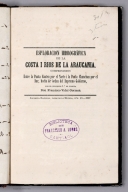
Full Title
(Covers to) Apuntes sobre la costa de Chile.
List No
14329.001
Note
Covers to Esploracion hidrográfica de la costa i Ríos de la Araucanía. Bound in board with leather spine. Front and back covers decorated with black and blue marbled paper. Gilded spine title, which translates to: Notes on the coast of Chile.
Author
Gormaz, Francisco Vidal, 1837-1907
Full Title
(Text Page to) [Book plate] -- [Annotations].
List No
14329.002
Note
On left - verso of front cover to Esploracion hidrográfica de la costa i Ríos de la Araucanía. With book plate, which has author's name: Fco. Vidal Gormáz. On right - originally blank (unnumbered) page with handwritten annotations, in ink, providing a list of items numbered 1 through 8.
Author
Gormaz, Francisco Vidal, 1837-1907
Full Title
(Title Page to) Esploracion hidrográfica de la costa i rios de la Araucanía, comprendidos entre la Punta Cauten por el norte i la Punta Chanchan por el sur, hecha de órden del Supremo Gobierno, por el Teniente 1o. de Marina, don Francisco Vidal Gormaz. Imprenta Nacional, Calle de la Moneda, Núm. 46. 1867.
List No
14329.003
Note
Title page to Esploracion hidrográfica de la costa i Ríos de la Araucanía. Title translates to: Hydrographic exploration of the coast and rivers of Araucanía. Includes imprint. With library stamp: Biblioteca de Francisco A. Lobos Santiago.
Author
Gormaz, Francisco Vidal, 1837-1907
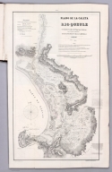
Full Title
Plano de la Caleta y Rio Queule levantado de orden del Supremo Gobierno por el Teniente 1o. de Marina dn. Francisco Vidal Gormaz. en 1866 i 1867. Lit. Cadot I Brandt, Santiago. Publicado por Decreto Supremo. No. 1.
List No
14329.004
Note
Nautical chart of the Caleta [Agua Fresca Bay] and Río Queule, Chile, from 1866 to 1867. Shows cities, roads, topography, vegetation, drainage, shorelines, shoals, islands and soundings. Relief illustrated with hachures. Includes a legend, coordinate points, two bar scales, a scale statement and a compass rose with north oriented toward top of sheet. Descriptive note beneath title. Text begins: La sonda trazada en el Río i sobre la barra, espresa pies ingleses i ha sido tomada en los momentos de baja marea [= The probe traced in the River and on the bar, expresed in English feet and taken at times of low tide]. Black and white lithograph. Chart is 62 x 35 cm, on fold-out sheet 71 x 44 cm. In first section of atlas, Esploracion hidrográfica de la costa i Ríos de la Araucanía.
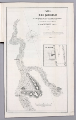
Author
Gormaz, Francisco Vidal, 1837-1907
Full Title
Plano del Rio Queule que comprende desde el punto a. del plano No. 1. hasta el punto donde fue esplorado. Levantado de orden del Supremo Gobierno por el Teniente 1o. de Marina dn. Francisco Vidal Gormaz. en 1866 i 1867. Lit. Cadot I Brandt, Santiago. Publicado por Decreto Supremo. No. 2.
List No
14329.005
Note
Nautical chart of the Río Queule, Chile, from 1866 to 1867. Shows cities, roads, topography, vegetation, drainage, shoreline and soundings. Relief illustrated with hachures. Includes coordinate points, two bar scales and a scale statement, as well arrows indicating the direction of water flow and a compass rose with north oriented toward top of sheet. Descriptive note beneath title. Text begins: El Río Voroa, afluente principal del Queule, es remanso, profundo i navegable por embarcaciones menores en toda la estencion que ha sido esplorado [= The Voroa River, the main tributary of the Queule, is a backwater, deep and navigable by smaller vessels throughout the estuary that has been explored.]. With inset chart: Los Boldos. Black and white lithograph. Chart is 64 x 37 cm, on fold-out sheet 71 x 44 cm. In first section of atlas, Esploracion hidrográfica de la costa i Ríos de la Araucanía.
Author
Gormaz, Francisco Vidal, 1837-1907
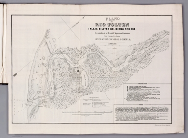
Full Title
Plano del Rio Tolten i plaza militar del mismo nombre. Levantado de orden del Supremo Gobierno por el Teniente 1o. de Marina dn. Francisco Vidal Gormaz. en 1866 i 1867. Publicado por Decreto Supremo.
List No
14329.006
Note
Nautical chart of the Río Tolten [Toltén River] and the military plaza of the same name, Chile, from 1866 to 1867. Shows cities, roads, topography, vegetation, drainage, shorelines, shoals, islands, anchorage and soundings. Relief illustrated with hachures. Includes a legend, coordinate points, two bar scales and a scale statement, as well arrows indicating the direction of water flow and a compass rose with north oriented toward top right of sheet. Descriptive note in bottom right corner. Text begins: La marea del Océano hincha las aguas del Río pero sin tornar el curso de éstas hácia adentro [= The tide of the ocean swells the waters of the river but without turning the course of these inwards]. Black and white lithograph. Chart is 33 x 49 cm, on fold-out sheet 40 x 54 cm. In first section of atlas, Esploracion hidrográfica de la costa i Ríos de la Araucanía.
Author
[Gormaz, Francisco Vidal, 1837-1907, Molinas, Francisco Javier, Castillo, Luis A.]
Full Title
Plano del Rio Cruces i sus afluentes, levantado de órden del Smo. Gno. durante los meses de Noviembre i Diciembre de 1867 i Enero, Febrero i Marzo de 1868, por La Comision Esploradora del Rio Valdivia, compuesta del Tte. 1o. Fco. Vidal Gormaz, Jefe de ella, i de los Ttes. 2os. Fco. Javier Molinas i Luis A. Castillo. Lita. Cadot I Brandt, Santiago.
List No
14329.007
Note
Nautical chart of the Río Cruces [Cruces River] and its tributaries, Chile, during November and December, 1867, as well as January, February and March, 1868. Shows cities, roads, vegetation, drainage, shorelines, shoals and islands. Includes latitudinal and longitudinal lines, two bar scales and a scale statement, as well a compass rose with north oriented toward top of sheet. Descriptive note beneath title. Text begins: Las lineas fuertes indican la parte esplorada por la Comision i las lineas auxiliares ó cortadas la prolongacion aparente de los Ríos [= The strong lines indicate the part explored by the Commission and the auxiliary or cut lines the apparent prolongation of the rivers]. Black and white lithograph. Chart is 37 x 48 cm, on fold-out sheet 49 x 52 cm. In first section of atlas, Esploracion hidrográfica de la costa i Ríos de la Araucanía.
Author
Gormaz, Francisco Vidal, 1837-1907
Full Title
(Section Title Page to) Continuacion de los Trabajos de Esploracion del Rio Valdivia i sus afluentes por el Capitan Graduado de Corbeta Francisco Vidal Gormaz. Santiago de Chile. Imprenta Nacional, Calle de la Moneda, No. 46. Julio de 1869.
List No
14329.008
Note
Section title page to the second section of Esploracion hidrográfica de la costa i Ríos de la Araucanía. Title translates to: Continuation of the Exploration Works of the Valdivia River and its tributaries. Includes imprint.
Author
Gormaz, Francisco Vidal, 1837-1907
Full Title
Secciones Trasversales de la Caja del Rio Calle-Calle : Fig. 1. Seccion en Puconu -- Fig. 2. Seccion frente al Rio Malihue -- Fig. 3. Seccion frente a la Mn. de Quinchilca. Lama. I.
List No
14329.009
Note
Three cross section views of the Río Calle-Calle [Calle-Calle River], Chile. Three different segments of the river, each with depth measurements. Descriptive note in bottom margin. Text: El punto A señala la caja que ocupan las aguas del rio [= Point A indicates the rea that the river waters occupy]. Black and white lithograph. Together, cross sections are 19 x 11 cm, on sheet 24 x 15 cm. In second section of atlas, Continuacion de los Trabajos de Esploracion del Rio Valdivia i sus afluentes.
Author
Gormaz, Francisco Vidal, 1837-1907
Full Title
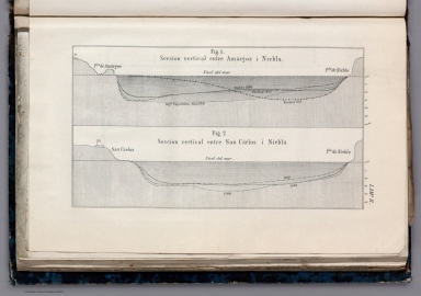
Fig. 1. Seccion vertical entre Amárgos i Niebla -- Fig. 2. Seccion vertical entre San Cárlos i Niebla. Lama. II.
List No
14329.010
Note
Two cross section views showing the areas between Amárgos and Niebla, as well as San Cárlos and Niebla, Chile. Different explorers and dates listed in association with depth measurements. Black and white lithograph. Together, cross sections are 10 x 18 cm, on fold-out sheet 15 x 24 cm. In second section of atlas, Continuacion de los Trabajos de Esploracion del Rio Valdivia i sus afluentes.
Author
Gormaz, Francisco Vidal, 1837-1907
Full Title
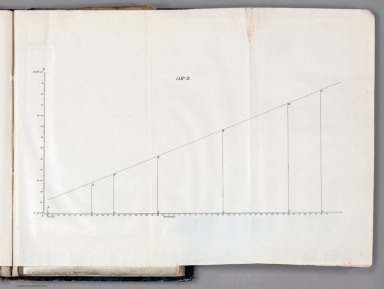
Lama. B.
List No
14329.011
Note
Statistical chart showing data on an incline from October 10 to November 30, [1869]. Black and white lithograph. Chart is 10 x 18 cm, on fold-out sheet 14 x 17 cm. In second section of atlas, Continuacion de los Trabajos de Esploracion del Rio Valdivia i sus afluentes.
Author
[Gormaz, Francisco Vidal, 1837-1907, Molinas, Francisco Javier, Castillo, Luis A.]
Full Title
Plano del Rio Calle-Calle i sus tributarios, levantado de órden del Supremo Gobierno durante los años de 67 a 69. Por La Comision Esploradora del Rio Valdivia, compuesta del Capan. de Cta. Grado. Fco. Vidal Gormaz, Jefe de ella, i de los Tenientes 2os. Fco. Javier Molinas i Luis A. Castillo. Lit. Cadot I Brandt, Santo.
List No
14329.012
Note
Nautical chart of the Río Calle-Calle [Calle-Calle River] and its tributaries, Chile, from the years 1867 to 1869. Shows cities, roads, topography, vegetation, drainage, shorelines, shoals and islands. Relief illustrated with hachures. Includes latitudinal and longitudinal lines, a scale statement and a compass rose with north oriented toward top of sheet. Descriptive note beneath title. Text begins: En este plano hemos correjido los errores de lonjitud de que estaba asectado el Rio Crúces [= In this plan we have corrected the errors in the length of the Rio Crúces, according to the publication of last year]. Black and white lithograph. Chart is 49 x 68 cm, on fold-out sheet 57 x 73 cm. In second section of atlas, Continuacion de los Trabajos de Esploracion del Rio Valdivia i sus afluentes.
Author
Gormaz, Francisco Vidal, 1837-1907
Full Title
(Section Title Page to) Reconocimientos de la costa comprendida entre la rada de Los Vilos i el Rio Chopa, i del Rio Valdiva i costa comprendida entre el Morro Bonifacio i el Rio Maullin, verificados de órden del supremo gobierno por Francisco Vidal Gormaz, Capitan graduado de Corbeta. Santiago de Chile. Imprenta Nacional, Calle de la Moneda, No. 46. 1870.
List No
14329.013
Note
Section title page to the third section of Esploracion hidrográfica de la costa i Ríos de la Araucanía. Title translates to: The coast between Los Vilos and the Choapa River, and the Valdivia River and the coast between the Morro Bonifacio [headland located in Los Lagos] and the Maullín River. Includes imprint.
Author
Gormaz, Francisco Vidal, 1837-1907
Full Title
Plano de la costa de Chile comprendida entre la punta Ventana por el norte i la ensenada del Negro por el sur. Levantado de órden del Supremo Gobierno én Octubre de 1869. Por el Can. de Corbeta Gdo. D. Fco. Vidal Gormáz, i los Oficiales de la Corbeta Chacabuco.
List No
14329.014
Note
Nautical chart of the Chilean coast, between Punta Ventana [= "Window Point"] in the north and Ensenada del Negro [= "Black Cove"] in the south, in October, 1869. Shows cities, roads, topography, vegetation, drainage, shorelines, shoals, islands and soundings. Relief illustrated with hachures. Includes latitudinal and longitudinal lines, statements of scale and magnetic declination, as well as a compass rose with north oriented toward right of sheet. Descriptive note beneath title. Text begins: La sonda está espresada en brazas inglesas [= The probe is expressed in English fathoms]. With three inset views: [Roca Corales ; Rada los Vilos al E. ; Isla Huevos] -- [Punta Ventana ; Punta Loberia al E.] -- [Punta Ventanas ; Caleta de Huenteláugquen al E.] Black and white lithograph. Chart is 42 x 69 cm, on fold-out sheet 55 x 73 cm. In third section of atlas, Reconocimientos de la costa comprendida entre la rada de Los Vilos i el Rio Chopa ...
Author
Gormaz, Francisco Vidal, 1837-1907
Full Title
Plano del Rio Valdivia i sus tributarios australes. Lit. Cadot I Brandt, Santiago.
List No
14329.015
Note
Nautical chart of the Río Valdivia [Valdivia River] and its southern tributaries, Chile, in 1869. Shows cities, roads, drainage, shorelines, shoals and islands. Includes latitudinal and longitudinal lines, a scale statement and a compass rose with north oriented toward top of sheet. Black and white lithograph. Chart is 26 x 28 cm, on fold-out sheet 32 x 31 cm. In third section of atlas, Reconocimientos de la costa comprendida entre la rada de Los Vilos i el Rio Chopa ...
|


![Text: [Book plate] ...](https://www.davidrumsey.com/rumsey/Size2/RUMSEY~8~1/205/14329002.jpg)