Who What Where WhenWHATShow MoreWHEREShow More |
Author
Jaeger, Johann Wilhelm Abraham
Full Title
(Covers to) Grand Atlas D'Allemagne En LXXXI Feuilles.
List No
15954.001
Author
[Jaeger, Johann Wilhelm Abraham, Brion, M.]
Full Title
Mappe Monde En Deux Hemisphere, ou sont Marquees les Decouvertes les plus recentes et les Routes, des tois Voyages de Cook
List No
15954.002
Note
World map by Brion inserted in the front of the atlas.,
Author
Jaeger, Johann Wilhelm Abraham
Full Title
(Title page to) (Feuille I) Grand Atlas D'Allemagne En LXXXI Feuilles.
List No
15954.003
Author
Jaeger, Johann Wilhelm Abraham
Full Title
Plan De La Nouvelle Carte Geographique Speciale D'Allemagne.Grand Atlas D'Allemagne En LXXXI Feuilles.
List No
15954.004
Note
Shows the placement of all 81 sheets.
Author
Jaeger, Johann Wilhelm Abraham
Full Title
Feuille II Grand Atlas D'Allemagne En LXXXI Feuilles.
List No
15954.005
Author
Jaeger, Johann Wilhelm Abraham
Full Title
Feuille III Grand Atlas D'Allemagne En LXXXI Feuilles.
List No
15954.006
Author
Jaeger, Johann Wilhelm Abraham
Full Title
Feuille IV Grand Atlas D'Allemagne En LXXXI Feuilles.
List No
15954.007
Author
Jaeger, Johann Wilhelm Abraham
Full Title
Feuille V Grand Atlas D'Allemagne En LXXXI Feuilles.
List No
15954.008
Author
Jaeger, Johann Wilhelm Abraham
Full Title
Feuille VI Grand Atlas D'Allemagne En LXXXI Feuilles.
List No
15954.009
Author
Jaeger, Johann Wilhelm Abraham
Full Title
Feuille VII Grand Atlas D'Allemagne En LXXXI Feuilles.
List No
15954.010
Author
Jaeger, Johann Wilhelm Abraham
Full Title
Feuille VIII Grand Atlas D'Allemagne En LXXXI Feuilles.
List No
15954.011
Author
Jaeger, Johann Wilhelm Abraham
Full Title
Feuille IX Grand Atlas D'Allemagne En LXXXI Feuilles.
List No
15954.012
Author
Jaeger, Johann Wilhelm Abraham
Full Title
Feuille X Grand Atlas D'Allemagne En LXXXI Feuilles.
List No
15954.013
Author
Jaeger, Johann Wilhelm Abraham
Full Title
Feuille XI Grand Atlas D'Allemagne En LXXXI Feuilles.
List No
15954.014
Author
Jaeger, Johann Wilhelm Abraham
Full Title
Feuille XII Grand Atlas D'Allemagne En LXXXI Feuilles.
List No
15954.015
Author
Jaeger, Johann Wilhelm Abraham
Full Title
Feuille XIII Grand Atlas D'Allemagne En LXXXI Feuilles.
List No
15954.016
Author
Jaeger, Johann Wilhelm Abraham
Full Title
Feuille XIV Grand Atlas D'Allemagne En LXXXI Feuilles.
List No
15954.017
Author
Jaeger, Johann Wilhelm Abraham
Full Title
Feuille XV Grand Atlas D'Allemagne En LXXXI Feuilles.
List No
15954.018
Author
Jaeger, Johann Wilhelm Abraham
Full Title
Feuille XVI Grand Atlas D'Allemagne En LXXXI Feuilles.
List No
15954.019
Author
Jaeger, Johann Wilhelm Abraham
Full Title
Feuille XVII Grand Atlas D'Allemagne En LXXXI Feuilles.
List No
15954.020
Author
Jaeger, Johann Wilhelm Abraham
Full Title
Feuille XVIII Grand Atlas D'Allemagne En LXXXI Feuilles.
List No
15954.021
Author
Jaeger, Johann Wilhelm Abraham
Full Title
Feuille LXXIII Grand Atlas D'Allemagne En LXXXI Feuilles.
List No
15954.076
Author
Jaeger, Johann Wilhelm Abraham
Full Title
Feuille LXXIV Grand Atlas D'Allemagne En LXXXI Feuilles.
List No
15954.077
Author
Jaeger, Johann Wilhelm Abraham
Full Title
Feuille LXXV Grand Atlas D'Allemagne En LXXXI Feuilles.
List No
15954.078
Author
Jaeger, Johann Wilhelm Abraham
Full Title
Feuille LXXVI Grand Atlas D'Allemagne En LXXXI Feuilles.
List No
15954.079
Author
Jaeger, Johann Wilhelm Abraham
Full Title
Feuille LXXVII Grand Atlas D'Allemagne En LXXXI Feuilles.
List No
15954.080
Author
Jaeger, Johann Wilhelm Abraham
Full Title
Feuille LXXVIII Grand Atlas D'Allemagne En LXXXI Feuilles.
List No
15954.081
Author
Jaeger, Johann Wilhelm Abraham
Full Title
Feuille LXXIX Grand Atlas D'Allemagne En LXXXI Feuilles.
List No
15954.082
Author
Jaeger, Johann Wilhelm Abraham
Full Title
Feuille LXXX Grand Atlas D'Allemagne En LXXXI Feuilles.
List No
15954.083
Author
Jaeger, Johann Wilhelm Abraham
Full Title
Feuille LXXXI Grand Atlas D'Allemagne En LXXXI Feuilles.
List No
15954.084
Author
Jaeger, Johann Wilhelm Abraham
Full Title
Poliometria Germaniae Ac Finitimorum Quorundam Locorum Europa excusa Per Matthaeum Seutt. S.C. M.G. August.
List No
15954.085
Author
Hughes, William, 1818-1876
Full Title
(Covers to) Philips' general atlas of the world.
List No
14487.001
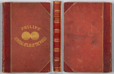
Note
Covers to Philips' general atlas of the world. Bound in boards with red leather spine and corners. With gilt title on front cover and spine. Front cover features a world map, presented as spherical Northern and Southern Hemispheres.
Author
Hughes, William, 1818-1876
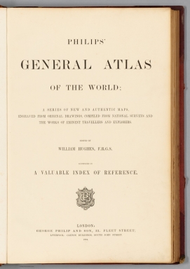
Full Title
(Title Page to) Philips' general atlas of the world; a series of new and authentic maps, engraved from original drawings, compiled from national surveys and the woks of eminent travellers and explorers. Edited by William Hughes, F.R.G.S. Accompanied by a valuable index of reference. London: George Philip and Son, 32, Fleet Street; Liverpool: Caxton Buildings, South John Street.
List No
14487.002
Note
Title page to Philips' general atlas of the world. Includes a description of contents, statement of responsibility, and imprint.
Author
Hughes, William, 1818-1876
Full Title
(Contents to) Contents.
List No
14487.003
Note
Table of contents to Philips' general atlas of the world. Includes indices to maps of countries and continents.
Author
[Hughes, William, 1818-1876, Bartholomew, John, 1831-1893]
Full Title
The world on a plane of a meridian. -- The world on the plane of the equator. -- The world on the plane of the horizon of London. By J. Bartholomew, F.R.G.S. George Philip & Son, London & Liverpool.
List No
14487.004
Note
Three maps representing the world, with hemispheres divided between the Western and Eastern Hemispheres, as well as the Southern and Northern Hemispheres, on both the plane of the equator, and the plane of the horizon of London. Maps show political boundaries, cities, topography, bodies of water, drainage, coastlines, and islands. Relief shown with hachures. Maps include latitudinal and longitudinal lines. Scales differ. Colored lithograph. Together, maps are 50 x 60 cm, on double sheet 56 x 70 cm.
Author
[Hughes, William, 1818-1876, Bartholomew, John, 1831-1893]
Full Title
The world on Mercator's projection. By J. Bartholomew, F.R.G.S. George Philip & Son, London & Liverpool.
List No
14487.005
Note
Map representing the world. Shows political boundaries, cities, topography, bodies of water, drainage, coastlines, and islands. Relief shown with hachures. Includes sailing routes and distances. With latitudinal and longitudinal lines. Colored lithograph. Map is 51 x 63 cm, on double sheet 56 x 70 cm.
Author
[Hughes, William, 1818-1876, Bartholomew, John, 1831-1893]
Full Title
Europe. By J. Bartholomew, F.R.G.S. George Philip & Son, London & Liverpool.
List No
14487.006
Note
Map representing Europe. Shows political boundaries, railways, cities, topography, bodies of water, drainage, coastlines, and islands. Relief shown with hachures. Includes latitudinal and longitudinal lines, as well as bar scales given in British miles, geographical miles, and kilometers. Colored lithograph. Map is 52 x 61 cm, on double sheet 56 x 70 cm.
Author
Hughes, William, 1818-1876
Full Title
The British Empire in 1864 : On a uniform scale of 1:20,000,000 : North America -- The British Islands -- India -- Ascension -- St. Helena -- Falkland -- Bermuda -- Mauritius -- Sketch map of the world, showing the relative positions of the various portions of The British Empire. -- Gibraltar -- Malta -- Heligoland -- Aden -- Hong Kong -- Labuan -- New Zealand -- West Indies -- West Africa -- South Africa -- Norfolk -- Australia. By W. Hughes, F.R.G.S. George Philip & Son, London & Liverpool.
List No
14487.007
Note
Twenty-one maps representing the British Empire in 1864. Maps show political boundaries, cities, bodies of water, drainage, coastlines, and islands. Maps include latitudinal and longitudinal lines, as well as bar scales given in English miles and kilometers. With statistical tables showing square meters and population for each map. Colored lithograph. Together, maps are 51 x 61 cm, on double sheet 56 x 70 cm.
Author
Hughes, William, 1818-1876
Full Title
Industrial map of the British Islands exhibiting the chief localities of manufacturing and commercial industry : With the ratio of population in the different counties, and the towns classified according to their respective populations. By W. Hughes, F.R.G.S. George Philip & Son, London & Liverpool.
List No
14487.008
Note
Map representing industry in the British Isles. With two ancillary maps: Map showing the distribution of the chief mineral productions of The British Islands. -- Map showing the comparative density of population in the different parts of the British Islands. Maps show county boundaries, railways, cities, bodies of water, canals, drainage, coastlines, and islands. Maps include latitudinal and longitudinal lines, as well as a legend and bar scales given in English miles and kilometers. With one inset map: Shetland Isds. Colored lithograph. Together, maps are 61 x 51 cm, on double sheet 70 x 56 cm. With handwritten annotations in red.
Author
[Hughes, William, 1818-1876, Bartholomew, John, 1831-1893]
Full Title
England and Wales. -- The Scilly Islands. By J. Bartholomew, F.R.G.S. George Philip & Son, London & Liverpool.
List No
14487.009
Note
Map representing England and Wales. Shows political boundaries, cities, topography, railways, roads, bodies of water, drainage, coastlines, and islands. Relief shown with hachures. Includes a table of population density, sailing routes and distances, latitudinal and longitudinal lines, as well as bar scales given in English miles and kilometers. With one inset map: The Scilly Islands. Colored lithograph. Map is 61 x 51 cm, on double sheet 70 x 56 cm.
Author
[Hughes, William, 1818-1876, Bartholomew, John, 1831-1893]
Full Title
Scotland. By J. Bartholomew, F.R.G.S. George Philip & Son, London & Liverpool.
List No
14487.010
Note
Map representing Scotland. Shows political boundaries, cities, topography, railways, roads, bodies of water, drainage, coastlines, and islands. Relief shown with hachures. Includes sailing routes and distances, latitudinal and longitudinal lines, as well as bar scales given in English miles, geographical miles, and kilometers. With one inset map: [Shetland Islands and Orkney Islands]. Colored lithograph. Map is 61 x 51 cm, on double sheet 70 x 56 cm.
Author
[Hughes, William, 1818-1876, Bartholomew, John, 1831-1893]
Full Title
Ireland. By J. Bartholomew, F.R.G.S. George Philip & Son, London & Liverpool.
List No
14487.011
Note
Map representing Ireland. Shows political boundaries, cities, topography, railways, roads, bodies of water, drainage, coastlines, and islands. Relief shown with hachures. Includes sailing routes and distances, latitudinal and longitudinal lines, as well as bar scales given in English miles, geographical miles, and kilometers. Colored lithograph. Map is 61 x 51 cm, on double sheet 70 x 56 cm.
Author
Hughes, William, 1818-1876
Full Title
France as divided into departments. By W. Hughes, F.R.G.S. George Philip & Son, London & Liverpool.
List No
14487.012
Note
Map representing France. With one ancillary map: France as divided into provinces, before the revolution of 1789. Shows political boundaries, cities, topography, railways, roads, bodies of water, drainage, coastlines, and islands. Relief shown with hachures. Includes latitudinal and longitudinal lines, as well as a legend and bar scales given in English miles, geographical miles, and kilometers. With one inset map: Corsica. Colored lithograph. Map is 51 x 59 cm, on double sheet 56 x 70 cm.
Author
[Hughes, William, 1818-1876, Bartholomew, John, 1831-1893]
Full Title
Holland and Belgium. By J. Bartholomew, F.R.G.S. George Philip & Son, London & Liverpool.
List No
14487.013
Note
Map representing Holland [Netherlands] and Belgium. Shows political boundaries, cities, railways, roads, bodies of water, drainage, coastlines, and islands. Includes latitudinal and longitudinal lines, as well as a legend and bar scales given in English miles, geographical miles, and kilometers. Colored lithograph. Map is 61 x 51 cm, on double sheet 70 x 56 cm.
Author
[Hughes, William, 1818-1876, Bartholomew, John, 1831-1893]
Full Title
Switzerland. By J. Bartholomew, F.R.G.S. George Philip & Son, London & Liverpool.
List No
14487.014
Note
Map representing Switzerland. Shows political boundaries, cities, topography, railways, roads, bodies of water, drainage, and shore lines. Relief shown with hachures. Includes latitudinal and longitudinal lines, as well as a legend and bar scales given in English miles, geographical miles, and kilometers. Colored lithograph. Map is 52 x 61 cm, on double sheet 56 x 70 cm.
Author
[Hughes, William, 1818-1876, Bartholomew, John, 1831-1893]
Full Title
Minor states of Germany. By J. Bartholomew, F.R.G.S. George Philip & Son, London & Liverpool.
List No
14487.015
Note
Map representing Germany. With one ancillary map: Sketch map shewing the extent of the Germanic Confederation. Maps show political boundaries, cities, topography, railways, roads, bodies of water, drainage, and shore lines. Relief shown with hachures. Maps include latitudinal and longitudinal lines, as well as bar scales given in English miles, geographical miles, and kilometers. Colored lithograph. Together maps are 51 x 61 cm, on double sheet 56 x 70 cm.
Author
[Hughes, William, 1818-1876, Bartholomew, John, 1831-1893]
Full Title
Austrian Empire. By J. Bartholomew, F.R.G.S. George Philip & Son, London & Liverpool.
List No
14487.016
Note
Map representing the Austrian Empire. Shows political boundaries, cities, topography, railways, roads, bodies of water, drainage, and coastlines. Relief shown with hachures. Includes latitudinal and longitudinal lines, as well as bar scales given in English miles, geographical miles, and kilometers. Colored lithograph. Map is 52 x 63 cm, on double sheet 56 x 70 cm.
Author
[Hughes, William, 1818-1876, Bartholomew, John, 1831-1893]
Full Title
Prussia. By J. Bartholomew, F.R.G.S. George Philip & Son, London & Liverpool.
List No
14487.017
Note
Map representing Prussia. Shows political boundaries, cities, topography, railways, roads, bodies of water, drainage, coastlines, and islands. Relief shown with hachures. Includes latitudinal and longitudinal lines, as well as a legend and bar scales given in English miles, geographical miles, and kilometers. Colored lithograph. Map is 54 x 65 cm, on double sheet 56 x 70 cm.
Author
[Hughes, William, 1818-1876, Bartholomew, John, 1831-1893]
Full Title
Denmark with the foreign possessions of the Danish crown. -- Denmark. -- (1) Iceland. -- (2) The Danish Settlements on the west coast of Greenland. -- (3) Copenhagen. -- (4) Faroe Islands. -- (5) Bornholm. -- (6) The Danish West Indies. By J. Bartholomew, F.R.G.S. George Philip & Son, London & Liverpool.
List No
14487.018
Note
Seven maps representing Denmark and its colonial possessions. Maps show political boundaries, cities, topography, railways, roads, bodies of water, drainage, coastlines, and islands. Relief shown with hachures. Maps include latitudinal and longitudinal lines, as well as bar scales given in English miles, kilometers, and Danish miles. Colored lithograph. Together, maps are 51 x 61 cm, on double sheet 56 x 70 cm.
Author
[Hughes, William, 1818-1876, Bartholomew, John, 1831-1893]
Full Title
(Scandinavia) Sweden and Norway. By J. Bartholomew, F.R.G.S. George Philip & Son, London & Liverpool.
List No
14487.019
Note
Map representing Sweden and Norway. Shows political boundaries, cities, topography, railways, roads, bodies of water, drainage, coastlines, and islands. Relief shown with hachures. Includes latitudinal and longitudinal lines, as well as a legend and bar scales given in English miles, geographical miles, kilometers, Swedish miles, and Norwegian miles. Colored lithograph. Map is 63 x 52 cm, on double sheet 70 x 56 cm.
|