|
Author
Schedel, Hartmann (1440-1514)
Full Title
Blat CXL Argentina Straszburg (Nuremberg Chronicle) Register DES BUCHS DER CRO=NICKEN und geschichten mit figure…
List No
15906.151
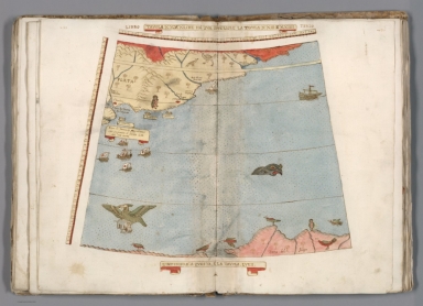
Author
Monte (Monti), Urbano, 1544-1613
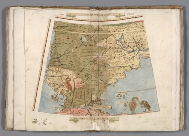
Full Title
Tavola XXXX. Che Ha Sua Superiore La Tavola. XXIII. Libro Terzo.
List No
10130.042
Author
Monte (Monti), Urbano, 1544-1613
Full Title
Tavola XXXXI. Che Ha Sua Superiore La Tavola. XXIII. E.XXIIII. Libro Terzo.
List No
10130.043
Author
[Mercator, Gerhard, 1512-1594, Hondius, Jodocus, 1563-1612]
Full Title
Exquisita & magno aliquot mensium periculo lustrata ct iam retecta Freti Magellanici Facies. Eijgentlicke afbeeldinghe der Magellanischer Strate die nu met veel gevaers ettelijekc. Maenden doonsien, van nieus ondeckt is. Inset: Dese Eijlanden die in gheene Pascaerten aengeteeckent bevonden en worden, Liggen van d'incomste der Strate Magellani O.N.O. verscheijden 50 mijlen op de hoochde van 5I graden.
List No
10501.517
Author
[Mercator, Gerhard, 1512-1594, Hondius, Iodocus, 1563-1612]
Full Title
Fretum Magellani. (to accompany) Atlas minor Gerardi Mercatoris.
List No
11201.464
Note
Map of the Straits of Magellan, with a decorative compass rose at the center. Relief shown pictorially.
Author
[Ortelius, Abraham, 1527-1598, Vrients, Jan Baptista]
Full Title
(Text Page) Nortgoia, Overo Il Palatinato Di Baviera. Il Territorio D'Argentina. 74
List No
10001.206
Author
[Wytfliet, Corneille, Magini, Giovanni Antonio]
Full Title
Chica sive Patagonica et Australis Terra. (to accompany) Histoire universelle des Indes occidentales et orientales, et de la conversion des Indiens : divisee en trois parties par Cornille Wytfliet & Anthoine Magin & autres historiens. Premiere Partie. A Douay, Chez Francois Fabri, l'An 1611.
List No
11622.013
Note
Uncolored engraved double page map divided in two sections. Shows Strait of Magellan or Patagonia and at the bottom shows a polar view of the Terra Australis with Southern Africa and Madagascar. Relief shown pictorially. Includes decorative title cartouche.
Author
[Wytfliet, Corneille, Magini, Giovanni Antonio]
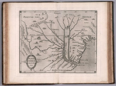
Full Title
Plata Americae provincia. (to accompany) Histoire universelle des Indes occidentales et orientales, et de la conversion des Indiens : divisee en trois parties par Cornille Wytfliet & Anthoine Magin & autres historiens. Premiere Partie. A Douay, Chez Francois Fabri, l'An 1611.
List No
11622.020
Note
Uncolored engraved double page map of the Rio de la Plata region. Covers Argentina, Uruguay and the southern part of Brazil. Shows cities, towns, landmarks, rivers, capes, bays and mountains. Relief shown pictorially. Includes decorative title cartouche.
Author
Le Maire, Jacques, 1585-1616
Full Title
[Patagones]. 1615 Decēb. Numero 1.
List No
14476.023
Note
View from Le Maire's travels in "Terra Australis" [Latin for "Southern Land"], featuring Puerto Deseado - "Port Desire" - in current-day Argentina. In December 1615, the expedition stopped in Port Desire for repairs. View shows topography, drainage, figures, fauna and flora. Relief shown figuratively. Includes a compass rose, with north oriented toward bottom of sheet. Indexed to indicate what appears within the view - such as ports, islands and sea lions - with key beneath. Black and white engraving. View is 20 x 17 cm, on sheet 29 x 19 cm. Appears in Spieghel der Australische navigatie, the third part of Nieuwe werelt anders ghenaempt West-Indien.
Author
Le Maire, Jacques, 1585-1616
Full Title
[Tierra del Fuogo].
List No
14476.024
Note
Map of Tierra del Fuego, an archipelago at South America’s southernmost tip, shared by current-day Chile and Argentina. Shows regions, bodies of water, drainage, coastlines and islands. Features voyages routes. Includes rhumb lines, latitudinal lines and a compass rose with north oriented toward top of sheet. With descriptive notes in cartouche. Black and white engraving. Map is 20 x 28 cm, on double sheet 29 x 36 cm. Appears in Spieghel der Australische navigatie, the third part of Nieuwe werelt anders ghenaempt West-Indien.
Author
[Mercator, Gerhard, 1512-1594, Hondius, Jodocus, 1563-1612, Hondius, Hendrik, 1597-1651]
Full Title
Exquisita & magno aliquot mensium periculo lustrata ct iam retecta Freti Magellanici Facies. Eijgentlicke afbeeldinghe der Magellanischer Strate die nu met veel gevaers ettelijekc. Maenden doonsien, van nieus ondeckt is. Inset: Dese Eijlanden die in gheene Pascaerten aengeteeckent bevonden en worden, Liggen van d'incomste der Strate Magellani O.N.O. verscheijden 50 mijlen op de hoochde van 5I graden.
List No
10534.365
Author
Blaeu, Willem Janszoon, 1571-1638
Full Title
Paraguay, O Prov. de Rio de la Plata.
List No
12202.064
Author
Blaeu, Willem Janszoon, 1571-1638
Full Title
Freti Magellanici ac novi Freti vulgo Le Maire.
List No
12202.065
Author
[Mercator, Gerhard, 1512-1594, Hondius, Jodocus, 1563-1612, Hondius, Hendrik, 1597-1651]
Full Title
Freti Magellanici ac novi Freti vulgo Le Maire exactissima delineatio. Lectori Meo. Descriptionem hanc novam freti Magellanici nobis communicavit clarissimus vir Bernardus Joannis Monasteriensis qui novem menses in peragratione huius freti impendit. sub duce Sebaldi de Waerdt Afbeelding ... is.
List No
10621.215
Author
[Mercator, Gerhard, 1512-1594, Hondius, Jodocus, 1563-1612, Saltonstall, Wye]
Full Title
The Straites of Magellana. (to accompany) Historia mundi : or Mercator's atlas. London Printed for Michaell Sparke, . and are to be sowld in Greene Arboiure, 1637. Second edytion.
List No
11248.686
Note
Copper-engraving uncolored map of the Straits of Magellan, with a decorative compass rose at the center. Relief shown pictorially.
Author
Sanson, Nicolas, 1600-1667
Full Title
Le Chili, tire de Alf de Qualle de la C.d.I. et divise en trieze jurisdictions. Par N. Sanson d'Abb. Geogr. ordre. du Roy ... 1657. (to accompany) L'Amerique en plusieurs cartes, & en divers traitte's de geographie et d'histoire ... A Paris chez l'Autheur.
List No
11576.058
Note
Copper engraved double page map of Chile and part of Argentina, hand colored in outline, with decorative cartouche. Showing political and administrative boundaries, major cities, towns, villages, rivers, mountains, drainage, etc. Relief shown pictorially.
Author
Sanson, Nicolas, 1600-1667
Full Title
Destroit de Magellan, Terre et Isles Magellanicques, &c. Par N. Sanson d'Abbeville Geogr. Ordinaire du Roy ... 1657. (to accompany) L'Amerique en plusieurs cartes, & en divers traitte's de geographie et d'histoire ... A Paris chez l'Autheur.
List No
11576.072
Note
Copper engraved double page map of Straights of Magellan, hand colored in outline, with decorative cartouche. Showing boundaries, major cities, coastal towns, villages, rivers, mountains, drainage, etc. Relief shown pictorially.
Author
Blaeu, Joan, 1596-1673
Full Title
Tabvla Magellanica
List No
15664.113
Note
20 Milliaria Germanica pro latitudinis gradu = 6.7-7.8 cm
Author
Blaeu, Joan, 1596-1673
Full Title
Paraqvaria Vulgo Paragvay
List No
15664.119
Author
Blaeu, Joan, 1596-1673
Full Title
Tabvla Magellanica
List No
10017.654
Note
20 Milliaria Germanica pro latitudinis gradu = 6.7-7.8 cm
Author
Blaeu, Joan, 1596-1673
Full Title
Paraqvaria Vulgo Paragvay
List No
10017.655
Author
Goos, Pieter, 1616-1675
Full Title
Paskaarte van Het Zuydelijckste van America.
List No
12179.045
Author
[Morden, Robert, approximately 1650-1703, Cockerill, Thomas, active 1674-1702]
Full Title
(Text Page to) Of Chili (1).
List No
14323.199
Note
Map of Chile and Paraguay. Map includes title cartouche: Chili and Paragay, by Robt. Morden. Shows cities, topography, drainage, coastline and islands. Relief shown pictorially. Contains latitudinal and longitudinal lines. Map is 11 x 12 cm, on sheet 15 x 20 cm. Accompanied by descriptive text. Includes section: Of Paraguay de la Plata. Text spans pages 410-412.
Author
[Morden, Robert, approximately 1650-1703, Cockerill, Thomas, active 1674-1702]
Full Title
(Text Page to) Of Magellanica (1).
List No
14323.202
Note
Map of Magellanica (modern-day Chile and Argentina). Map includes title cartouche: Terra Magellanica, by Rob. Morden. Shows cities, topography, drainage, coastline and islands. Relief shown pictorially. Contains latitudinal and longitudinal lines. Map is 12 x 10 cm, on sheet 15 x 20 cm. Accompanied by descriptive text. Text spans pages 416-418.
Author
Du Val, Pierre, 1619-1683
Full Title
Magellanique.
List No
12503.079
Author
Du Val, Pierre, 1619-1683
Full Title
Tucuman.
List No
12503.082
Author
[Visscher, Nicolaes, 1649-1702., Jansson, Johannes, 1588-1664]
Full Title
Tabula Magellanica, qua Tierrae del Fuego, cum celeberrimis fretis a F. Magellano et I. Le Maire detectis novissima et accuratissima descriptio exhibetur. Amstelodami. Apud Joannes Janssonium. (to accompany) Atlas minor sive totius orbis terrarum contracta delinea ex conatibus Nico. Visscher. 1690. (half title page) Atlas Minor sive Geographia Compendiosa, qua Orbis Terrarum.
List No
11755.130
Note
Hand colored in outline engraved map with dedication text and explanation table. Shows cities, towns, waterways, canals and mountains. Includes decorative carouches, compass roses, and vignette of ships in the ocean and native settlements in land. Relief shown pictorially.
Author
Wit, Frederick de (1629-1706)
Full Title
Tractus Australior Americae Meridionalis, a Rio de la Plata per Fretum Magellanicum ad Toraltum. | Nieuwe Perfecte Pascaert van 't Suyderlyckste deel van Suyt America, van Rio de la Plata door de Straet Magellaen tot Toral.
List No
15889.036
Author
[Sanson, Nicolas, 1600-1667, Sanson, Guillaume (1633-1703)]
Full Title
La Chili (Chile).
List No
9741.143
Author
[Sanson, Nicolas, 1600-1667, Sanson, Guillaume (1633-1703)]
Full Title
La Terre et les Isles Magellaniques (Magellan Isles).
List No
9741.146
Author
Fer, Nicolas de, 1646-1720
Full Title
Le Chili et ... Rio de la Plata.
List No
12201.142
Author
[Chatelain Henri, 1684-1743, Gueudeville, Nicolas]
Full Title
Carte de la Terre Ferme du Perou, du Bresil, et du Pays des Amazones : Dressee sur les memoires les plus nouveaux & les observations les plus exactes. Tom. VI. No. 31. Pag. 122. (to accompany) Atlas Historique ... Tome VI. A Amsterdam, chez L'Honore & Chatelain Libraires. M DCC XIX (1719).
List No
13272.718
Note
Engraved folded map of the northern part of South America. Covers Colombia, Venezuela, Peru, Ecuador, Brazil, Guiana and parts of Bolivia, Chile, Paraguay and Argentina. Shows cities, towns, roads, Indian tribes and the tributaries of the Amazon. Includes descriptive text. Relief shown pictorially.
Author
[Chatelain Henri, 1684-1743, Gueudeville, Nicolas]
Full Title
Carte du Paraguai, du Chili, du Detroit de Magellan, &c. : Dressee sur les memoires les plus nouveaux & les observations les plus exactes. Tom. VI. No. 33. Pag. 135. (to accompany) Atlas Historique ... Tome VI. A Amsterdam, chez L'Honore & Chatelain Libraires. M DCC XIX (1719).
List No
13272.727
Note
Engraved map of southern part of South America. Shows political boundaries, province, cities, towns, rivers, lakes and mountains. Relief shown pictorially. Shows exploration and expeditions routes of Magellan, Schouten & Le Maire, Mendana & Gallego, Sarmiento and Drake in the Pacific, with extensive notations. The date of European discovery of many islands is recorded.
Author
Bowen, Emanuel
Full Title
A new and accurate map of Chili, Terra Magellanica, Terra del Fuego &c. Laid down according to the latest improvements and regulated by astronl. observatns. By Eman: Bowen. (London: Printed for William Innys, Richard Ware, Aaron Ward, J. and P. Knapton, John Clarke, T. Longman and T. Shewell, Thomas Osborne, Henry Whitridge ... M.DCC.XLVII)
List No
3733.053
Note
Engraved map. Shows forested areas, etc. Includes geographical notes and ornamental cartouche. Relief shown pictorially. Inset maps: A plan of the City of Saint Iago, Capital of the Kingdom of Chili -- A chart of the extreme part of South America ... Scale [ca. 1:590,000]
Author
Fer, Nicolas de, 1646-1720
Full Title
Partie la plus meridionale de l'Ame��rique, ou se trouve le Chili, le Paraguay, et les terres Magellaniques avec les fameux detroits de Magellan et de le Maire : Dresse��e sur diverse me��moires et re��lations des filibustiers et fameux voyageurs
List No
10022.108
Author
[Bowen, Emanuel, Gibson, John]
Full Title
Paraguay And Tucuman. (to accompany) Atlas Minimus or a New Set of Pocket Maps of the Several Empires, Kingdoms and States of the Known World, with Historical Extracts relative to each. Drawn and Engraved by J. Gibson from the Best Authorities, Revis'd, Corrected and Improv'd by Eman: Bowen Geographer to His Majesty.
List No
0300.055
Note
First edition. The "Historical Extracts" are short bits of text printed on the maps giving relevant geographical information. A revised edition was published in London in 1792. In 1759, another edition was published adding separate geographical descriptions and correcting some of the maps (see our copy). The Philadelphia 1798 edition by Mathew Carey incorporates the 1759 edition text word for word (excepting the maps of United States which Carey omits in favor of his pocket atlas of the U.S.). Gibson and Bowen made the four sheet map of North America (Stevens 49), and Gibson made the four sheet map of America (Stevens 3).
Author
[Lattre, Jean, 1743 -1793, L'Isle, Guillaume de, 1675-1726, Buache, Philippe]
Full Title
Carte du Paraguay, du Chili, du Detroit de Magellan &c. Dressée sur les Descriptions des P. P. Alfonse d'Ovalle, et Nicolas Techo et sur les Relations et memoires de Brouwer, Narbouroug, Mr. de Beauchesne & Par Guillaume De L'Isle ... 1703. Gravee par Liebaux le fils ... C. Simonneau inv. et fecit. Ph. Buache P.G.d.R. d. l'A. R.d.S. Gendre de l'Auteur. Avec Privilege du 30 Av. 1745. (to accompany) Atlas Geographique contenant la Mappemonde et les quatre parties, avec les differents Etats, avec apprpbation & privilage du Roy MDCC.LXIII (1763).
List No
11335.047
Note
Engraved outlined hand color map. Includes place names, and ornamental title cartouche. Relief shown pictorially.
Author
Bellin, Jacques Nicolas, 1703-1772
Full Title
Carte de la riviere de La Plata.
List No
6903.175
Note
Decorative title cartouche. Relief shown pictorially and by hachures. Depth shown by soundings. Shows settlements.
Author
Bellin, Jacques Nicolas, 1703-1772
Full Title
Ville de Buenos Ayres.
List No
6903.176
Note
Detailed map of the city, shows and identifies major buildings.
Author
Bellin, Jacques Nicolas, 1703-1772
Full Title
Carte du Paraguay et pays voisins
List No
6903.177
Note
Decorative title cartouche. Relief shown pictorially. Shows settlements.
Author
Bellin, Jacques Nicolas, 1703-1772
Full Title
Carte reduite de la partie la plus meridionale de I'Amerique.
List No
6903.178
Note
Relief shown pictorially and by hachures. Shows settlements.
Author
Bellin, Jacques Nicolas, 1703-1772
Full Title
Carte des isles Malouines on isles nouvelles que les anglois noment aujourd'hui isles de Falkland.
List No
6903.179
Note
Shows settlements and adjoining islands.
Author
Bellin, Jacques Nicolas, 1703-1772
Full Title
Carte reduite du detroit do Magellan dressee sur les journaux des navigateurs.
List No
6903.180
Note
Under Remarks, Bellin states that he bases his chart on the surveys of Labat and Beauchesne who spent 7 months in the area in 1699.
Author
Bellin, Jacques Nicolas, 1703-1772
Full Title
Carte du detroit de la Maire.
List No
6903.181
Note
Decorative title cartouche. Relief shown pictorially and by hachures. Depth shown by soundings. Shows settlements.
Author
[Bellin, Jacques Nicolas, 1703-1772, Depot de la Marine]
Full Title
Carte Hydrographique de la Riviere de la Plata.
List No
12059.119
Note
From J.F. Letenneur: "Exceptional onboard document of this rare and fabulous maritime atlas, a masterpiece by the greatest French hydrographer of the 18th century, with maps of all the coastlines known at the time. Bound with the coat of arms of the King of France, the atlas was taken by the English aboard the frigate la Nymphe, off the coasts of Ushant August 10, 1780, during one of the naval battles of the American War of Independence which took place on European waters. In the context of the war at the end of the 18th century, and of the rivalry between the French and British Navy, maritime atlases, were strategic tools, and this “Hydrographie Françoise” more so than any other, because its purpose was to provide the best maritime charts for the French ships that were fighting on the American side against the British. (The handwritten captions throughout most of the atlas are prices for individual maps and all include the same mention: “for sailors”). These atlases were not the kind to be kept in a library, but precious tools, based on the observations of the travelers and continuously improved upon, as reflect in the present copy. It was bound with the engraved title page of the edition of 1737-1765, but the index includes maps printed after 1765 (until 1772), and the copy was augmented by six maps that do not appear in the index (until 1776), as well as 14 pages of text from the Versailles edition of 1773. The later maps are signed by Verdun de la Crenne and were done during the campaigns of the Flore (1771-1772) and of the Isis led by Fleurieu in 1768-1769. The captions explain that the maps were created using the latest technology of the day that could measure longitude (maritime clocks)." (Continued in the Pub Note field).
Author
[Cook, James, 1728-1779, Hawkesworth, John, 1715?-1773]
Full Title
A plan of Success Bay in Strait le Maire. A chart of the S.E. part of Terra del Fuego including Strait le Maire and part of Staten-land by Lieutenant J. Cook 1769. T. Bowen & J. Gibson sculp. (London: printed for W. Strahan; and T. Cadell in the Strand, MDCCLXXIII).
List No
3403.020
Note
Two engraved nautical charts. Relief shown by hachures and pictorially; depths by soundings. Scales [ca. 1:38,000] and [ca. 1:2,600,000]. Four coastal views at top of sheet: A view of part of the N.E. side of Terra del Fuego taken from the point A. in the chart -- A view of Strait Le Maire with part of Terra del Fuego and Staten Land taken from the point B. in the chart -- A view of part of the S.W. side of Terra del Fuego taken from the point C. in the chart -- A view of part of the coast of Terra del Fuego from Cape Horn to Isle Evouts, taken from the point D. in the chart.
Author
[Cook, James, 1728-1779, Hawkesworth, John, 1715?-1773]
Full Title
(A view of the Indians of Terra del Fuego in their hut). G.B. Cipriani del. F. Bartolozzi sculp. No. 1. (London: printed for W. Strahan; and T. Cadell in the Strand, MDCCLXXIII)
List No
3403.021
Note
Engraved illustration. Title from Mitchell.
Author
Jefferys, Thomas
Full Title
A Chart Of The Straits Of Magellan. Inlarged From The Chart Published At Madrid in 1769, by Don Juan de la Cruz Cano y Olmedilla of the Royal Academy of St. Fernando. and Improved from the Observations and Surveys of Captns. Byron, Wallis and Carteret compared with those of Monsr. De Bougainville. (with) A Chart of Magellania with Falkland's Islands. London. Printed for R. Sayer and J. Bennett ... 1st July 1775.
List No
0346.035
Note
In outline color with a great amount of detail about the topography and people of the region.
Author
Masi, Giovanni Tommaso
Full Title
Carta esatta rappresentante il corso del fiume Paraguay ed i paesi ad esso vicini. D. Verem. Rossi fe.
List No
14343.054
Note
Map of the Paraguay River, which flows through Brazil, Bolivia, Paraguay and Argentina. Shows river and river valley, with political boundaries, cities, topography, drainage and coastlines. Relief shown pictorially. Includes latitudinal and longitudinal lines. Black and white engraving, with title in banner. Map is 19 x 24 cm, on fold-out sheet 37 x 47 cm. Descriptive text for map appears on pages 14 -15 of Dexcrizione delle carte geografiche, which precedes maps.
Author
Cook, James, 1728-1779
Full Title
A chart of the southern extremity of America 1775. (with) Part of Staten Land. No. II. Published Febry. 1st, 1777 by Wm. Strahan in New Street, Shoe Lane & Thos. Cadell in the Strand, London.
List No
3404.062
Note
Engraved nautical chart showing coastal outlines. Depths shown by soundings. Covers Patagonia, Tierra del Fuego and the Falkland Islands. Scale of inset (ca. 1:162,000).
|


![[Patagones]. 1615 Decēb. Numero 1.](https://www.davidrumsey.com/rumsey/Size1/RUMSEY~8~1/205/14476023.jpg)
![[Tierra del Fuogo].](https://www.davidrumsey.com/rumsey/Size2/RUMSEY~8~1/205/14476024.jpg)


