|
REFINE
Search Results: All Fields similar to 'Brooklyn and New and York and N and Y'Author
[Great Britain. War Office, Stevens, Benjamin Franklin]
Full Title
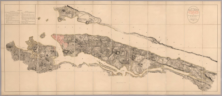
(Covers to) B.F. Steven's Facsimile of the Unpublished British Head Quarters Coloured Manuscript map of New York & Environs, 1782, Reproduced from the original drawing in the War Office, London. Issued only to subscribers at 4, Trafalgar Square, W.C., London. 1900. Malby and Sons. Engravers.
List No
6403.001
Note
From the printed advertisement for the map: "BF STEVENS'S Facsimile of the Unpublished British Headquarters Coloured Manuscript Map of New York and Environs 1782. Reproduced from the Original Drawing in the War Office London. 24 sheets Scale 6 1/2 inches to a mile. 10 feet by 4 feet. The successive British Commanders in Chief in America Generals Sir William Howe, Sir Henry Clinton, and Sir Guy Carleton during their respective occupations of New York and Environs in the Revolution caused this manuscript plan from time to time to be kept up. The plan extends from below Guanas Bay to the Heights of Spikendevi, a distance of about eighteen or nineteen miles. It shows the Fortifications, Defenses, Topography, Streets, Roads, etc. of the whole of the Island of New York with the Harbor Islands, Water Ways, and River Frontages on the Hudson and East Rivers, the Military Works on Long Island including Brooklyn, the Works in Paulus Hook and parts of the Jersey Shore. It has a copious Table of References to various works British and American, some of them with notes as to the time of their construction or destruction. The Original Drawing, ten feet by four feet, is on a scale of about six and a half inches to a mile. It is handsomely reproduced for subscribers only in careful facsimile on 24 sheets which can be joined up and mounted like the original as a Wall Map or mounted on linen if desired. It will be issued either mounted on linen to fold in book form with leather slip case 13 x 10 inches or the 24 sheets 22 x 15 inches, each will be supplied in a portfolio. No more than 100 copies are being printed and the engravings are erased as each sheet is printed off. A few extra copies of sheet 8 have been printed so that it can be sent as a specimen on application from intending subscribers. Prices to Subscribers Mounted on linen to fold in book form with leather slip case $30 ne.t Unmounted on 34 sheets in portfolio $25 net. The above prices include delivery to any Public Libra
Author
[Great Britain. War Office, Stevens, Benjamin Franklin]
Full Title
(Map Title Page to) B.F. Steven's Facsimile of the Unpublished British Head Quarters Coloured Manuscript map of New York & Environs, 1782, Reproduced from the original drawing in the War Office, London. Issued only to subscribers at 4, Trafalgar Square, W.C., London. 1900. Malby and Sons. Engravers.
List No
6403.002
Note
From the printed advertisement for the map: "BF STEVENS'S Facsimile of the Unpublished British Headquarters Coloured Manuscript Map of New York and Environs 1782. Reproduced from the Original Drawing in the War Office London. 24 sheets Scale 6 1/2 inches to a mile. 10 feet by 4 feet. The successive British Commanders in Chief in America Generals Sir William Howe, Sir Henry Clinton, and Sir Guy Carleton during their respective occupations of New York and Environs in the Revolution caused this manuscript plan from time to time to be kept up. The plan extends from below Guanas Bay to the Heights of Spikendevi, a distance of about eighteen or nineteen miles. It shows the Fortifications, Defenses, Topography, Streets, Roads, etc. of the whole of the Island of New York with the Harbor Islands, Water Ways, and River Frontages on the Hudson and East Rivers, the Military Works on Long Island including Brooklyn, the Works in Paulus Hook and parts of the Jersey Shore. It has a copious Table of References to various works British and American, some of them with notes as to the time of their construction or destruction. The Original Drawing, ten feet by four feet, is on a scale of about six and a half inches to a mile. It is handsomely reproduced for subscribers only in careful facsimile on 24 sheets which can be joined up and mounted like the original as a Wall Map or mounted on linen if desired. It will be issued either mounted on linen to fold in book form with leather slip case 13 x 10 inches or the 24 sheets 22 x 15 inches, each will be supplied in a portfolio. No more than 100 copies are being printed and the engravings are erased as each sheet is printed off. A few extra copies of sheet 8 have been printed so that it can be sent as a specimen on application from intending subscribers. Prices to Subscribers Mounted on linen to fold in book form with leather slip case $30 ne.t Unmounted on 34 sheets in portfolio $25 net. The above prices include delivery to any Public Libra
Author
[Great Britain. War Office, Stevens, Benjamin Franklin]
Full Title
B.F. Steven's Facsimile of the Unpublished British Head Quarters Coloured Manuscript map of New York & Environs, 1782, Reproduced from the original drawing in the War Office, London. Issued only to subscribers at 4, Trafalgar Square, W.C., London. 1900. Malby and Sons. Engravers.
List No
6403.003
Note
From the printed advertisement for the map: "BF STEVENS'S Facsimile of the Unpublished British Headquarters Coloured Manuscript Map of New York and Environs 1782. Reproduced from the Original Drawing in the War Office London. 24 sheets Scale 6 1/2 inches to a mile. 10 feet by 4 feet. The successive British Commanders in Chief in America Generals Sir William Howe, Sir Henry Clinton, and Sir Guy Carleton during their respective occupations of New York and Environs in the Revolution caused this manuscript plan from time to time to be kept up. The plan extends from below Guanas Bay to the Heights of Spikendevi, a distance of about eighteen or nineteen miles. It shows the Fortifications, Defenses, Topography, Streets, Roads, etc. of the whole of the Island of New York with the Harbor Islands, Water Ways, and River Frontages on the Hudson and East Rivers, the Military Works on Long Island including Brooklyn, the Works in Paulus Hook and parts of the Jersey Shore. It has a copious Table of References to various works British and American, some of them with notes as to the time of their construction or destruction. The Original Drawing, ten feet by four feet, is on a scale of about six and a half inches to a mile. It is handsomely reproduced for subscribers only in careful facsimile on 24 sheets which can be joined up and mounted like the original as a Wall Map or mounted on linen if desired. It will be issued either mounted on linen to fold in book form with leather slip case 13 x 10 inches or the 24 sheets 22 x 15 inches, each will be supplied in a portfolio. No more than 100 copies are being printed and the engravings are erased as each sheet is printed off. A few extra copies of sheet 8 have been printed so that it can be sent as a specimen on application from intending subscribers. .." <a href=http://www.davidrumsey.com/view/google-earth-browser#new-york-1782 target=_blank>View in Google Earth</a>
Author
[Great Britain. War Office, Stevens, Benjamin Franklin]
Full Title
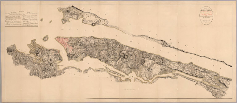
(Composite of) B.F. Steven's Facsimile of the Unpublished British Head Quarters Coloured Manuscript map of New York & Environs, 1782, Reproduced from the original drawing in the War Office, London. Issued only to subscribers at 4, Trafalgar Square, W.C., London. 1900. Malby and Sons. Engravers.
List No
6403.004
Note
(Composite removing linen gaps between sections). From the printed advertisement for the map: "BF STEVENS'S Facsimile of the Unpublished British Headquarters Coloured Manuscript Map of New York and Environs 1782. Reproduced from the Original Drawing in the War Office London. 24 sheets Scale 6 1/2 inches to a mile. 10 feet by 4 feet. The successive British Commanders in Chief in America Generals Sir William Howe, Sir Henry Clinton, and Sir Guy Carleton during their respective occupations of New York and Environs in the Revolution caused this manuscript plan from time to time to be kept up. The plan extends from below Guanas Bay to the Heights of Spikendevi, a distance of about eighteen or nineteen miles. It shows the Fortifications, Defenses, Topography, Streets, Roads, etc. of the whole of the Island of New York with the Harbor Islands, Water Ways, and River Frontages on the Hudson and East Rivers, the Military Works on Long Island including Brooklyn, the Works in Paulus Hook and parts of the Jersey Shore. It has a copious Table of References to various works British and American, some of them with notes as to the time of their construction or destruction. The Original Drawing, ten feet by four feet, is on a scale of about six and a half inches to a mile. It is handsomely reproduced for subscribers only in careful facsimile on 24 sheets which can be joined up and mounted like the original as a Wall Map or mounted on linen if desired. It will be issued either mounted on linen to fold in book form with leather slip case 13 x 10 inches or the 24 sheets 22 x 15 inches, each will be supplied in a portfolio. No more than 100 copies are being printed and the engravings are erased as each sheet is printed off. A few extra copies of sheet 8 have been printed so that it can be sent as a specimen on application from intending subscribers..." <a href=http://www.davidrumsey.com/view/google-earth-browser#new-york-1782 target=_blank>View in Google Earth</a>
Author
Klinckowstrom, Axel Leonhard
Full Title
Newyorks Hamn och Redd Fran Brooklyn pa Longisland. Rit. af Klinckowstrom. Gr. af Akrell. (Stockholm: Stente af C. Muller, 1824)
List No
5757.015
Note
Engraved view of New York Harbor and docks from Brooklyn on Long Island in 1820. "Only known state. This view is interesting particularly as showing the types of steam ferries and sail-boats in use at this period."--Stokes.
Author
Burr, David H., 1803-1875
Full Title
(Covers to) City Of New-York. Published by David H. Burr, 217 Broadway. Entered ... 1832 by David H. Burr ... New York. Engraved & Printed by Illman & Pilbrow, N.Y.
List No
4331.001
Note
First edition. A rare and beautiful map. Shows Manhattan Island north to 34th Street, with portions of Brooklyn. Not in Phillips, or any references. Ristow, p. 315, mentions another, smaller map by Burr that was used in Disturnell's New York As It Is (see our copies-Haskell 765). This first edition is not in Haskell, who only lists a later edition of this map republished by Stone in 1838 and a different, larger map of similar title (Haskell 755) published in many editions by Colton and Stiles (1833 and later). This edition is engraved by Illman and Pilbrow who also engraved the maps for Burr's 1836 Universal Atlas. Full color map, folded into brown leather covers 14x9 with "New York City" stamped in gilt.
Author
Burr, David H., 1803-1875
Full Title
City Of New-York. Published by David H. Burr, 217 Broadway. Entered ... 1832 by David H. Burr ... New York. Engraved & Printed by Illman & Pilbrow, N.Y.
List No
4331.002
Note
First edition. A rare and beautiful map. Shows Manhattan Island north to 34th Street, with portions of Brooklyn. Not in Phillips, or any references. Ristow, p. 315, mentions another, smaller map by Burr that was used in Disturnell's New York As It Is (see our copies-Haskell 765). This first edition is not in Haskell, who only lists a later edition of this map republished by Stone in 1838 and a different, larger map of similar title (Haskell 755) published in many editions by Colton and Stiles (1833 and later). This edition is engraved by Illman and Pilbrow who also engraved the maps for Burr's 1836 Universal Atlas. Full color map, folded into brown leather covers 14x9 with "New York City" stamped in gilt.
Author
Burr, David H., 1803-1875
Full Title
Map of New York Exhibiting the Post Offices, Post Roads, Canals, Rail Roads, &c. By David H. Burr. (Late Topographer to the Post Office.) Geographer to the House of Representatives of the U.S. (with) City And County Of New-York Brooklyn, Williamsburg & Jersey City. John Arrowsmith. Entered ... July 10th, 1839, by David H. Burr ... District of Columbia.
List No
0104.003
Note
In full color by county. Map of New York City uncolored. Postal routes by coach, stage, sulkey, cross, rail roads and canals shown. In 8 sections mounted on linen. Label on back states "No. 3. New York."
Author
[Disturnell, John, Smith, J. Calvin, Tanner, T.R.]
Full Title
(Covers to) A Guide To The City Of New-York; Containing An Alphabetical List Of Streets, &c. Accompanied By A New And Correct Map. New-York: Published By Tanner & Disturnell. 1840. (on verso) Entered ... 1839, by Tanner & Disturnell ... New-York. Sackett & Sargent, Printers, No. 1 Nassau-street, corner of Wall. (with) New Map of the City Of New York, With Brooklyn & Parts Of Williamsburgh; By J. Calvin Smith. Engraved on steel by Stiles, Sherman & Smith. Published By Tanner & Disturnell. No. 124 Broadway. 1840. Entered ... 1839 by J. Disturnell ... New York.
List No
3180.001
Note
The title page says Tanner & Disturnell - we assume it is T.R. Tanner. Covers are a dark mauve cloth with "New-York City Guide. 1840" stamped in gold. On the inside front cover is a bookplate showing the buildings and streets of New York.
Author
[Disturnell, John, Smith, J. Calvin, Tanner, T.R.]
Full Title
(Title Page to) A Guide To The City Of New-York; Containing An Alphabetical List Of Streets, &c. Accompanied By A New And Correct Map. New-York: Published By Tanner & Disturnell. 1840. (on verso) Entered ... 1839, by Tanner & Disturnell ... New-York. Sackett & Sargent, Printers, No. 1 Nassau-street, corner of Wall. (with) New Map of the City Of New York, With Brooklyn & Parts Of Williamsburgh; By J. Calvin Smith. Engraved on steel by Stiles, Sherman & Smith. Published By Tanner & Disturnell. No. 124 Broadway. 1840. Entered ... 1839 by J. Disturnell ... New York.
List No
3180.002
Note
The title page says Tanner & Disturnell - we assume it is T.R. Tanner. Covers are a dark mauve cloth with "New-York City Guide. 1840" stamped in gold. On the inside front cover is a bookplate showing the buildings and streets of New York.
Author
[Disturnell, John, Smith, J. Calvin, Tanner, T.R.]
Full Title
New Map of the City Of New York, With Brooklyn & Parts Of Williamsburgh; By J. Calvin Smith. Engraved on steel by Stiles, Sherman & Smith. Published By Tanner & Disturnell. No. 124 Broadway. 1840. Entered ... 1839 by J. Disturnell ... New York. (with) A Guide To The City Of New-York; Containing An Alphabetical List Of Streets, &c. Accompanied By A New And Correct Map. New-York: Published By Tanner & Disturnell. 1840. (on verso) Entered ... 1839, by Tanner & Disturnell ... New-York. Sackett & Sargent, Printers, No. 1 Nassau-street, corner of Wall.
List No
3180.003
Note
The title page says Tanner & Disturnell - we assume it is T.R. Tanner. Covers are a dark mauve cloth with "New-York City Guide. 1840" stamped in gold. On the inside front cover is a bookplate showing the buildings and streets of New York.
Author
Smith, J. Calvin
Full Title
New Map of the City of New York with Brooklyn & Part of Williamsburg; by J. Calvin Smith.
List No
0980.073
Author
Mitchell, Samuel Augustus
Full Title
City of New-York. (Published by S. Augustus Mitchell, Philadelphia. 1846). Entered ... 1835 by H.S. Tanner ... Pennsylvania.
List No
0536.002
Note
Map printed in color -- outline color by ward, in red and blue ink -- rather than the more normal (for this period) hand color. Shows streets, major buildings, etc. Covers Manhattan below 39th Street and portions of Brooklyn and Williamsburg.
Author
[Fitch, George W., Hyde, Frances]
Full Title
No. 4 Fitch's Chorography. Map of the State of New York, Drawn by Frances Hyde. Pubd. by A.M. Wilder, 51 Fulton St. Brooklyn, N.Y. & by Wilder & Co. 139 Atlantic St. Entered ... 1848 by A.M. Wilder ... New York. Lat. & Long. Lithographed by B.F. Butler 146 William St. New York.
List No
3547.000
Note
Single sheet from Fitch's Mapping Plates. Base of lat/long lines given with Frances Hyde drawing in outline color the map of the state by county. Relief shown by hachures.
Author
[Ensign & Thayer, Atwood, J. M.]
Full Title
(Covers to) Map Of The City Of New York, With The Adjacent Cities Of Brooklyn & Jersey City, And The Village Of Williamsburg. Published By Ensign & Thayer, 50 Ann St. New York. 1849. Entered ... 1844 by Humphrey Phelps ... Drawn & Engraved by John M. Atwood. 19 Beekman St. N.Y. (inset) Jersey City. (inset) New York Island. (with street directory titled) A Map Of The City And County Of New York, With The Adjacent Cities Of Brooklyn And Jersey City, And The Village Of Williamsburg: With A Street Directory Of The City Of New York. New York: Published By Ensigns & Thayer, 50 Ann Street. 1849.
List No
4337.001
Note
First edition of the street directory, third edition of the map. The first edition of the map was 1844, without the directory (Haskell 871). Humphrey Phelps held the original copyright. See later editions by Thayer, Bridgman & Fanning. The map is folded into stamped gray-green cloth covers with "Ensign's & Thayer's Map Of The City Of New York" in gilt. The street directory is 28 pages.
Author
[Ensign & Thayer, Atwood, J. M.]
Full Title
Map Of The City Of New York, With The Adjacent Cities Of Brooklyn & Jersey City, And The Village Of Williamsburg. Published By Ensign & Thayer, 50 Ann St. New York. 1849. Entered ... 1844 by Humphrey Phelps ... Drawn & Engraved by John M. Atwood. 19 Beekman St. N.Y. (inset) Jersey City. (inset) New York Island. (with street directory titled) A Map Of The City And County Of New York, With The Adjacent Cities Of Brooklyn And Jersey City, And The Village Of Williamsburg: With A Street Directory Of The City Of New York. New York: Published By Ensigns & Thayer, 50 Ann Street. 1849.
List No
4337.002
Note
First edition of the street directory, third edition of the map. The first edition of the map was 1844, without the directory (Haskell 871). Humphrey Phelps held the original copyright. See later editions by Thayer, Bridgman & Fanning. The map is folded into stamped gray-green cloth covers with "Ensign's & Thayer's Map Of The City Of New York" in gilt. The street directory is 28 pages.
Author
Magnus, Charles
Full Title
(Covers to) City Of Brooklyn with Part of New York. Publh. & sold by Chs. Magnus No. 22 North William St. Vicinity of New York. Publ. & Sold by Magnus & Co. 77 Chatham St. Map of the City of Williamsburgh with Part of Greenpoint. Lith. of Chs. Magnus, N.Y. (Three small maps on one sheet).
List No
4227.001
Note
Another Magnus small pocket map of New York City. Folded into black paper covers 8.5x6 with "Complete Map of the Cities of Brooklyn, Williamsburgh, and A Part of New York" printed in golden yellow. We am guessing at several of the words in the cover title - it is very worn. Haskell does not list this exact title, but several that are similar.
Author
Magnus, Charles
Full Title
City Of Brooklyn with Part of New York. Publh. & sold by Chs. Magnus No. 22 North William St. (with map) Vicinity of New York. Publ. & Sold by Magnus & Co. 77 Chatham St. (with map) Map of the City of Williamsburgh with Part of Greenpoint. Lith. of Chs. Magnus, N.Y. (Three small maps on one sheet).
List No
4227.002
Note
Another Magnus small pocket map of New York City. Folded into black paper covers 8.5x6 with "Complete Map of the Cities of Brooklyn, Williamsburgh, and A Part of New York" printed in golden yellow. We am guessing at several of the words in the cover title - it is very worn. Haskell does not list this exact title, but several that are similar. Includes "Census 1851."
Author
Magnus, Charles
Full Title
(Covers to) Vicinity Of New York. Publ. & Sold by Chs. Magnus.
List No
3434.001
Note
Tiny map with Census of 1850 data below it. Map is folded into black paper-covered cloth covers 9.5x9 with "First Complete Map of the Cities of New York, Brooklyn & Williamsburgh 1852" printed in golden yellow.
Author
Magnus, Charles
Full Title
Vicinity Of New York. Publ. & Sold by Chs. Magnus.
List No
3434.002
Note
Tiny map with Census of 1850 data below it. Map is folded into black paper-covered cloth covers 9.5x9 with "First Complete Map of the Cities of New York, Brooklyn & Williamsburgh 1852" printed in golden yellow.
Author
[Colton, G.W., Colton, J. H.]
Full Title
(Covers to) Map Of The Country Thirty Three Miles Around The City Of New York. Published By J.H. Colton, No. 86 Cedar St. New York, 1853. Entered ... 1846, by J.H. Colton ... New York. Drawn by G.W. Colton. Engraved by J.M. Atwood, N.Y.
List No
0173A
Author
[Colton, G.W., Colton, J. H.]
Full Title
Map Of The Country Thirty Three Miles Around The City Of New York. Published By J.H. Colton, No. 86 Cedar St. New York, 1853. Entered ... 1846, by J.H. Colton ... New York. Drawn by G.W. Colton. Engraved by J.M. Atwood, N.Y.
List No
0173.001
Note
With red cloth covers 14.5x9 stamped with gilt title reading "Thirty Three Miles Around The City Of New-York." and a small circular map of New York (later editions omit the map on the cover). First issued in 1846, when it was reengraved by Atwood from J.H. Eddy's "Map of the Country Thirty Miles round the City of New York" which was originally issued in 1811 (see our #3472). This is one of Colton's most attractive maps, showing New York and vicinity in circular format surrounded by a vine border with views of City Hall, New York and City Hall, Brooklyn. It was published in many editions for almost fifty years - our latest edition is 1891 (Haskell lists eight editions from 1846 to 1873 only). The early editions were engraved on copper plate (our 1853) and at some point before our 1865 edition the copper plate was transferred to lithographic stone and all subsequent editions were lithographed.
Author
[Bache, A. D., Hassler, F. R.]
Full Title
Map of New-York Bay and Harbor and the environs. From a trigonometrical survey under the direction of F.R. Hassler, Superintendent of the Survey of the Coast of the United States. Triangulation by James Ferguson and Edmund Blunt, assistants. The hydrography under the direction of Thomas R. Gedney, Lieutenant, U.S. Navy. The topography by C. Renard, T.A. Jenkins & B.F. Sands, assists. Published in 1845. A.D. Bache, Superintendent. Topography engraved by S. Siebert & A. Rolle, views engraved by O.A. Lawson. Engraving supervised & views of the coast drawn by J. Farley. Hydrography engraved by F. Dankworth, lettering by F. Dankworth & J. Knight. Electrotype copy no. 5 by G. Mathiot, U.S.C.S. (with logo) U.S. Coast Survey Depot.
List No
2470.020
Note
Engraved nautical chart. Relief shown by hachures; depths by soundings. Includes 4 coastal views and notes. Covers Lower Manhattan, Brooklyn, Jersey City, New York Bay, Raritan Bay, Sandy Hook, Newark Bay, South Oyster Bay, Hempstead Bay, Staten Island, etc. In upper margin "Presented under authority of an act of Congress of the United States of June 3d 1844 by direction of the Treasury Department, A.D. Bache Superintendent Coast Survey." Prime meridians: Greenwich and New York.
Author
Dripps, Matthew
Full Title
(Covers to) Map of the Cities of New York, Brooklyn, Williamsburgh & Jersey City. Published by M. Dripps No. 103 Fulton St. New York 1854.
List No
3429.001
Note
Not listed by Haskell, but similar to 1005, on the same scale. Probably one of Dripps' first New York City pocket maps. Haskell lists none that are before 1854, only Dripps' larger wall maps of the city, the first of which was published in 1851. Also similar to Haskell 1010 of 1855 - same scale (1 inch = 1800 feet) and size but with the title changed to "Map of the Cities of New York, Brooklyn & Jersey City". All three of these maps are from the same mother map. Map is folded into black stamped cloth covers 13x9 with "Dripps' Map Of New York." in gilt.
Author
Dripps, Matthew
Full Title
Map of the Cities of New York, Brooklyn, Williamsburgh & Jersey City. Published by M. Dripps No. 103 Fulton St. New York 1854.
List No
3429.002
Note
Not listed by Haskell, but similar to 1005, on the same scale. Probably one of Dripps' first New York City pocket maps. Haskell lists none that are before 1854, only Dripps' larger wall maps of the city, the first of which was published in 1851. Also similar to Haskell 1010 of 1855 - same scale (1 inch = 1800 feet) and size but with the title changed to "Map of the Cities of New York, Brooklyn & Jersey City". All three of these maps are from the same mother map. Map is folded into black stamped cloth covers 13x9 with "Dripps' Map Of New York." in gilt.
Author
Green-Wood Cemetery
Full Title
(Covers to) Green-Wood Cemetery. 1855. Snyder, Black & Sturn, Lith. 87 Fulton St. N.Y.
List No
3241.001
Note
One of the earliest "planned" cemeteries. In Brooklyn. No indication of the map maker. Snyder, Black & Sturn are the lithographers. The plots are numbered (no index with the map) and show lots of room at the top of the map for the inevitable expansion. Folded into stamped green cloth covers 16x10 with "Green-Wood" in gilt.
Author
Green-Wood Cemetery
Full Title
Green-Wood Cemetery. 1855. Snyder, Black & Sturn, Lith. 87 Fulton St. N.Y.
List No
3241.002
Note
One of the earliest "planned" cemeteries. In Brooklyn. No indication of the map maker. Snyder, Black & Sturn are the lithographers. The plots are numbered (no index with the map) and show lots of room at the top of the map for the inevitable expansion. Folded into stamped green cloth covers 16x10 with "Green-Wood" in gilt.
Author
Ensign, Bridgman & Fanning
Full Title
(Covers to) Fanning's Map of New-York City, Published By Ensign, Bridgman & Fanning, 156 William Street, Corner of Ann. New York. 1855. Entered ... 1853, by Horace Thayer & Co. ... N. York. (with index titled) A Map Of The City And County Of New York, With The Adjacent Cities Of Brooklyn And Jersey City, And The Village Of Williamsburg: With A Street Directory Of The City Of New York. New York: Thayer, Bridgman & Fanning ... 1854. (on page 1) Corrected October 20, 1849. Entered ... 1849, by H. Wilson ... New-York.
List No
3614.001
Note
With inset views of The Merchants' Exchange, Institution for the Blind, and The Custom House. The title page of the directory is dated 1854, but the map is dated 1855. With a two page catalogue of maps and charts offered by Thayer, Bridgman & Fanning. See first edition by Ensigns & Thayer (1849). Map is folded into stamped brown cloth covers 14.5x9 with "Map Of New-York City E,B, & F." stamped in gilt.
Author
Ensign, Bridgman & Fanning
Full Title
(Title page to) Fanning's Map of New-York City, Published By Ensign, Bridgman & Fanning, 156 William Street, Corner of Ann. New York. 1855. Entered ... 1853, by Horace Thayer & Co. ... N. York. (with index titled) A Map Of The City And County Of New York, With The Adjacent Cities Of Brooklyn And Jersey City, And The Village Of Williamsburg: With A Street Directory Of The City Of New York. New York: Thayer, Bridgman & Fanning ... 1854. (on page 1) Corrected October 20, 1849. Entered ... 1849, by H. Wilson ... New-York.
List No
3614.002
Note
With inset views of The Merchants' Exchange, Institution for the Blind, and The Custom House. The title page of the directory is dated 1854, but the map is dated 1855. With a two page catalogue of maps and charts offered by Thayer, Bridgman & Fanning. See first edition by Ensigns & Thayer (1849). Map is folded into stamped brown cloth covers 14.5x9 with "Map Of New-York City E,B, & F." stamped in gilt.
Author
Ensign, Bridgman & Fanning
Full Title
Fanning's Map of New-York City, Published By Ensign, Bridgman & Fanning, 156 William Street, Corner of Ann. New York. 1855. Entered ... 1853, by Horace Thayer & Co. ... N. York. (with index titled) A Map Of The City And County Of New York, With The Adjacent Cities Of Brooklyn And Jersey City, And The Village Of Williamsburg: With A Street Directory Of The City Of New York. New York: Thayer, Bridgman & Fanning ... 1854. (on page 1) Corrected October 20, 1849. Entered ... 1849, by H. Wilson ... New-York.
List No
3614.003
Note
With inset views of The Merchants' Exchange, Institution for the Blind, and The Custom House. The title page of the directory is dated 1854, but the map is dated 1855. With a two page catalogue of maps and charts offered by Thayer, Bridgman & Fanning. See first edition by Ensigns & Thayer (1849). Map is folded into stamped brown cloth covers 14.5x9 with "Map Of New-York City E,B, & F." stamped in gilt.
Author
Dripps, Matthew
Full Title
(Covers to) Topographical Map Of New York City, County And Vicinity, Showing the Original High Water Lines, Permanent Pier Lines, and the Present Wharves & Piers, compiled from authentic surveys. Published By M. Dripps, No. 103 Fulton St. New York 1855. Entered ... 1853 by M. Dripps ... N.Y. (inset map) New York-County North of 155 Street. (inset) Nieuw Amsterdam opt Eylant Manhattans 1656. Map Of New Netherlands. (inset) New Yorke 1695.
List No
4208.001
Note
Entered in 1853. Not in Haskell, although Haskell lists another map of about the same size, insets, and scale, with a different title. The map covers all of Manhattan and parts of Brooklyn and the New Jersey shore. Topography is shown (similar to the Viele map of 1868) with particular emphasis on the original shoreline and the made land and docks. Central Park is indicated by color with no name given. A very attractive map of the city showing the rapid development northward. Full color. Covers are dark brown cloth 22x13.5 stamped in gold with "Bulkhead & Pier Lines, Brooklyn & New York." Scarce.
Author
Dripps, Matthew
Full Title
Topographical Map Of New York City, County And Vicinity, Showing the Original High Water Lines, Permanent Pier Lines, and the Present Wharves & Piers, compiled from authentic surveys. Published By M. Dripps, No. 103 Fulton St. New York 1855. Entered ... 1853 by M. Dripps ... N.Y. (inset map) New York-County North of 155 Street. (inset) Nieuw Amsterdam opt Eylant Manhattans 1656. Map Of New Netherlands. (inset) New Yorke 1695.
List No
4208.002
Note
Entered in 1853. Not in Haskell, although Haskell lists another map of about the same size, insets, and scale, with a different title. The map covers all of Manhattan and parts of Brooklyn and the New Jersey shore. Topography is shown (similar to the Viele map of 1868) with particular emphasis on the original shoreline and the made land and docks. Central Park is indicated by color with no name given. A very attractive map of the city showing the rapid development northward. Full color. Covers are dark brown cloth 22x13.5 stamped in gold with "Bulkhead & Pier Lines, Brooklyn & New York." Scarce. Relief shown by hachures. Depth shown by isolines and soundings.
Author
[Phelps, Humphrey, Miller, James]
Full Title
New York City Map. Published By James Miller, 436 Broadway, New York. Entered ... 1857, by Humphrey Phelps ... New York.
List No
2133.002
Note
Full color. On the stamped brown cloth covers 15x9.5: "Miller's New Map Of The City Of New-York." Includes guide to New York City and Brooklyn streets and avenues. With vignette views of steam boats and ships. Shows wards, boundaries, fire districts, and railroads. Relief shown by hachures.
Author
Ensign, Bridgman & Fanning
Full Title
(Covers to) Map Of The City Of New York, With The Adjacent Cities Of Brooklyn, Jersey City, And Williamsburgh. Published By Ensign, Bridgman & Fanning. 156 William St. New York. 1860. Drawn & Engraved by John M. Atwood. 19 Beekman St. N.Y. Entered ... 1844 by Humphrey Phelps ... New York. (with two inset maps). (with index titled) A Map Of The City And County Of New York, With The Adjacent Cities Of Brooklyn And Jersey City, And The Village Of Williamsburg: With A Street Directory Of The City Of New York. New York: Thayer, Bridgman & Fanning, 156 William Street ... And 8 Exchange St., Buffalo. 1854. Entered ... 1849, by H. Wilson ... New-York.
List No
4338.001
Note
Although the 28 page index is dated 1854 on the title page, the map is dated 1860. See earlier editions of 1849 and 1855. Folded into textured brown cloth covers 14.5x9 with "Map Of New-York City E., B. & F." in gilt.
Author
Ensign, Bridgman & Fanning
Full Title
(Title Page to) A Map Of The City And County Of New York, With The Adjacent Cities Of Brooklyn And Jersey City, And The Village Of Williamsburg: With A Street Directory Of The City Of New York. New York: Thayer, Bridgman & Fanning, 156 William Street ... And 8 Exchange St., Buffalo. 1854. Entered ... 1849, by H. Wilson ... New-York. (to accompany) Map Of The City Of New York, With The Adjacent Cities Of Brooklyn, Jersey City, And Williamsburgh. Published By Ensign, Bridgman & Fanning. 156 William St. New York. 1860. Drawn & Engraved by John M. Atwood. 19 Beekman St. N.Y. Entered ... 1844 by Humphrey Phelps ... New York. (with two inset maps).
List No
4338.002
Note
Although the 28 page index is dated 1854 on the title page, the map is dated 1860. See earlier editions of 1849 and 1855. Folded into textured brown cloth covers 14.5x9 with "Map Of New-York City E., B. & F." in gilt.
Author
Ensign, Bridgman & Fanning
Full Title
Map Of The City Of New York, With The Adjacent Cities Of Brooklyn, Jersey City, And Williamsburgh. Published By Ensign, Bridgman & Fanning. 156 William St. New York. 1860. Drawn & Engraved by John M. Atwood. 19 Beekman St. N.Y. Entered ... 1844 by Humphrey Phelps ... New York. (with two inset maps).
List No
4338.003
Note
outline color map. Showing Ward boundaries and district lines. "The Red lines denote the boundaries of the Fire Districts ..."
Author
Meyer, Joseph, 1796-1856
Full Title
Plan von New-York, 1844. Verlag des Bibliographischen Instituts zu Hildburghausen, Amsterdam, Paris u. Philadelphia, (1860)
List No
4807.142
Note
Engraved map. Includes keys to points of interest. Shows wards, churches, etc. Covers also parts of Brooklyn and Williamsburg. "Meyer's Handatlas No. 27."
Author
City Directory Office
Full Title
Map Of The City Of New York. City Directory Office, 52 Greene St.
List No
4971.000
Note
A somewhat crude but detailed map showing Manhattan north to 118th Street, with portions of Brooklyn, Jersey City, and Hoboken. It was normally issued with Trow's New York City Directory, editions of 1860 to 1866, but was also issued as a separate, as is the example here. Map is without color. Relief shown by hachures.
Author
Colton, G.W.
Full Title
G. Woolworth Colton's Map of New York City, Brooklyn, Jersey City, Hoboken, etc. Published by G.W. & C.B. Colton & Co., No. 172 William St. New York.
List No
4825.029
Note
(inset) Continuation of the City and County of New York on a reduce scale. Pages 18 and 19 are displayed on top corners of map.
Author
Beers, Frederick W.
Full Title
Plan of New York and Brooklyn.
List No
0063.006
Author
Beers, Frederick W.
Full Title
Plan of New York and Brooklyn.
List No
0064.006
Author
Taintor Brothers
Full Title
(Covers to) The City Of New York. A Complete Guide. With Descriptive Sketches Of Objects And Places Of Interest. With Map. Entered ... 1867, by Taintor Brothers & Co. ... New York. New York: Taintor Brothers, 678 Broadway. (with map) New Map Of The Great Metropolis, Including The Cities Of New York, Brooklyn, Jersey City, Hoboken, & Co., Published By Taintor Brothers, 758 Broadway.
List No
0973.001
Note
An Eighty three page guide book with map. Orange card board cover reads "Taintor's Route And City Guides. City Of New York. Taintor Brothers, 678 Broadway, New York." Full color.
Author
Taintor Brothers
Full Title
(Title Page to) The City Of New York. A Complete Guide. With Descriptive Sketches Of Objects And Places Of Interest. With Map. Entered ... 1867, by Taintor Brothers & Co. ... New York. New York: Taintor Brothers, 678 Broadway. (with map) New Map Of The Great Metropolis, Including The Cities Of New York, Brooklyn, Jersey City, Hoboken, & Co., Published By Taintor Brothers, 758 Broadway.
List No
0973.002
Note
An Eighty three page guide book with map. Orange card board cover reads "Taintor's Route And City Guides. City Of New York. Taintor Brothers, 678 Broadway, New York." Full color.
Author
Taintor Brothers
Full Title
New Map Of The Great Metropolis, Including The Cities Of New York, Brooklyn, Jersey City, Hoboken, & Co., Published By Taintor Brothers, 758 Broadway. (with 83 p. text) The City Of New York. A Complete Guide. With Descriptive Sketches Of Objects And Places Of Interest. With Map. Entered ... 1867, by Taintor Brothers & Co. ... New York. New York: Taintor Brothers, 678 Broadway.
List No
0973.003
Note
An Eighty three page guide book with map. Orange card board cover reads "Taintor's Route And City Guides. City Of New York. Taintor Brothers, 678 Broadway, New York." Full color.
Author
Taintor Brothers
Full Title
(Text Page to) The City Of New York. A Complete Guide. With Descriptive Sketches Of Objects And Places Of Interest. With Map. Entered ... 1867, by Taintor Brothers & Co. ... New York. New York: Taintor Brothers, 678 Broadway. (with map) New Map Of The Great Metropolis, Including The Cities Of New York, Brooklyn, Jersey City, Hoboken, & Co., Published By Taintor Brothers, 758 Broadway.
List No
0973.004
Note
An Eighty three page guide book with map. Orange card board cover reads "Taintor's Route And City Guides. City Of New York. Taintor Brothers, 678 Broadway, New York." Full color.
Author
Beers, Frederick W.
Full Title
Plan of New York and Brooklyn.
List No
2609.006
Author
Beers, Frederick W.
Full Title
Plan of New York and Brooklyn.
List No
3086.006
Author
Lloyd, H.H.
Full Title
(Covers to) 40 Miles Around New York. Published by H.H. Lloyd & Co. 21 John St. New York 1867. Entered ... 1866, by H.H. Lloyd & Co. ... New York. (On Verso) H.H. Lloyd's New Map Of The Great Metropolis, Including The Cities Of New York, Brooklyn, Jersey City, Hoboken, &c. Published By H.H. Lloyd & Co. ... 1867. Eng'd by Fisk & Russell, 43 Chatham St. N.Y.
List No
3212.001
Note
Lloyd's usual disclaimer about the "other Lloyd." An intense map of the region around New York - intensely colored and dense with information. On the verso is a more "normal" looking city map, but with a catchy title - "the Great Metropolis." Catalogue of Lloyd's maps appears on the main map and on the verso of the front cover. Folded into dark brown cloth covers 16x10.5 with "H.H. Lloyd's New-York And Forty Miles Around It Streets Rail Roads &c." stamped in gold.
Author
Lloyd, H.H.
Full Title
40 Miles Around New York. Published by H.H. Lloyd & Co. 21 John St. New York 1867. Entered ... 1866, by H.H. Lloyd & Co. ... New York. (On Verso) H.H. Lloyd's New Map Of The Great Metropolis, Including The Cities Of New York, Brooklyn, Jersey City, Hoboken, &c. Published By H.H. Lloyd & Co. ... 1867. Eng'd by Fisk & Russell, 43 Chatham St. N.Y.
List No
3212.002
Note
Lloyd's usual disclaimer about the "other Lloyd." An intense map of the region around New York - intensely colored and dense with information. On the verso is a more "normal" looking city map, but with a catchy title - "the Great Metropolis." Catalogue of Lloyd's maps appears on the main map and on the verso of the front cover. Folded into dark brown cloth covers 16x10.5 with "H.H. Lloyd's New-York And Forty Miles Around It Streets Rail Roads &c." stamped in gold.
Author
Lloyd, H.H.
Full Title
H.H. Lloyd's New Map Of The Great Metropolis, Including The Cities Of New York, Brooklyn, Jersey City, Hoboken, &c. Published By H.H. Lloyd & Co. ... 1867. Eng'd by Fisk & Russell, 43 Chatham St. N.Y. (One Verso) 40 Miles Around New York. Published by H.H. Lloyd & Co. 21 John St. New York 1867. Entered ... 1866, by H.H. Lloyd & Co. ... New York.
List No
3212.003
Note
Lloyd's usual disclaimer about the "other Lloyd." An intense map of the region around New York - intensely colored and dense with information. On the verso is a more "normal" looking city map, but with a catchy title - "the Great Metropolis." Catalogue of Lloyd's maps appears on the main map and on the verso of the front cover. Folded into dark brown cloth covers 16x10.5 with "H.H. Lloyd's New-York And Forty Miles Around It Streets Rail Roads &c." stamped in gold.
|