Who What Where WhenWHEREShow More |
Author
Munster, Sebastian, 1488-1552
Full Title
Urbs Themistitana Hispaniae... Maedera
List No
15058.235
Author
Blaeu, Willem Janszoon, 1571-1638
Full Title
Pascaarte vande Eijlanden van Madera en Porto Santo, vertoonende de gelegentheÿt vande Reeden aldaer en hoese van malcanderen zijn gheleghen. = Carte marine de les Jsles de Madera et Porto Santo, monstrant comment elles sont situeez l'un de lautre, ensemble la situation de leurs Rades.
List No
14351.106
Note
Nautical chart showing the Madeira Islands and Porto Santo Island. Parallel titles appears in Dutch and French, translating (loosely) to: Nautical chart of the Islands of Madeira and Porto Santo ... Features cities, roads, ports, topography, coastlines, shoals, islands, anchorage, soundings and a ship. Relief shown pictorially. Includes three bar scales, latitudinal and longitudinal lines, rhumb lines and compass roses, with north oriented toward upper right. Decorative cartouches. With two inset bird's-eye views: [Angra] -- Sanct Michiels. Black and white engraving. Chart is 25 x 55 cm, on double sheet 26 x 58 cm. Appears in "Eerste boeck" of atlas.
Author
Sanson, Nicolas, 1600-1667
Full Title
Isles Canaries. Par N. Sanson, d'Abbeville Geographe Ordinai. du Roy ... 1656. J. L. scu. (to accompany) L'Afriqve en plusieurs cartes novvelles, et exactes; & en divers traittes de geographie, et d'histoire. (inset) Isle Madere.
List No
11575.077
Note
Copper engraved double page map of Canary Islands with an inset of Madeira, hand colored in outline, with decorative cartouche. Engraved by J. L'Huilier. Showing major cities, villages, harbors, rivers, mountains, etc. Relief shown pictorially.
Author
[Coronelli, Vincenzo (1650-1718), Accademia cosmografica degli Argonauti.]
Full Title
Isole Canarie : Possedutte da S.M. Cattolica, e descritte dal P.M. Coronelli ... (to accompany) Isolario descrittione geografico-historica, sacro-profana, antico-moderna ... e in supplimento dei XIV volumi del Bleau. Tomo II dell' Atlante veneto. Opera, e Studio del P. Maestro Vincenzo Coronelli ... A Spese dell Auttore MDCLXXXXVI (1696). (inset) Isola Madera. (with) Veduta della Citta di Fanchal nell'isola di Madera.
List No
11391.087
Note
Engraved map of the Canary Island group on the left side of the map, with decorative cartouches, on 2 sheets. Showing place names. Relief shown pictorially. The map is filled with notations and includes a portion of the African coastline. With two large insets. The upper inset is a detailed chart of the island of Madeira, and birds eye view of the town of Madera is shown below that shows buildings, lighthouse, fortifications and ships in the harbor and at the shore.
Author
Bowen, Emanuel
Full Title
A new & accurate map of the ... parts of Barbary, containing ... Drawn from the best authorities & regulated by astronl. observations. By Eman. Bowen. (London: Printed for William Innys, Richard Ware, Aaron Ward, J. and P. Knapton, John Clarke, T. Longman and T. Shewell, Thomas Osborne, Henry Whitridge ... M.DCC.XLVII)
List No
3733.046
Note
Engraved map in 2 segments. Covers also Madeira and part of the Canary Islands. Contents: Western parts of Barbary, containing Fez, Morocco, Algiers, Tunis & Biledulgerid -- Eastern parts of Barbary, containing Tripoli, Barca, Faisan, and the northern parts of Egypt ...
Author
Bowen, Emanuel
Full Title
Particular draughts of some of the chief African Islands in the Mediterranean, as also in the Atlantic and Ethiopic Oceans. By Eman. Bowen. (London: Printed for William Innys, Richard Ware, Aaron Ward, J. and P. Knapton, John Clarke, T. Longman and T. Shewell, Thomas Osborne, Henry Whitridge ... M.DCC.XLVII)
List No
3733.049
Note
Engraved plate with 8 maps. Relief shown pictorially. Each map contains historical and geographical note. Contents: An accurate map of the islands of Malta, Goze & Cuming -- An accurate chart of Cape de Verd Islands, being an improvement of Captn. Roberts's draught -- The Bay of Agoa de Saldanha -- Island of Teneriffe -- A plan of the Dutch Fort at the Cape of Good Hope -- A draught of Table Bay -- Island of Madera -- A correct map of the Island of St. Hellena, belonging to the English East India Company, by Eman. Bowen.
Author
[Mount, John, Page, Thomas, 1704-1762, Mount and Page]
Full Title
(Text Page) The English pilot for the Southern navigation : describing the sea-coasts, capes, headlands, bays, roads, harbours, rivers and ports : together with the soundings, sands, rocks and dangers on the coast of England, Scotland, Ireland, Holland, Flanders, Spain, Portugal, to the Streight's-Mouth, with the coasts of Barbary, and off to the Canary, Madeira, Cape de Verde and Western-Islands ... London : Printed for J. Mount and T. Page, on Tower Hill. M,DCC,LII (1752).
List No
13251.002
Note
Gift inscription from Adie Atkinson to John Atkinson, dated 1755.
Author
[Mount, John, Page, Thomas, 1704-1762, Mount and Page]
Full Title
(Title Page) The English pilot for the Southern navigation : describing the sea-coasts, capes, headlands, bays, roads, harbours, rivers and ports : together with the soundings, sands, rocks and dangers on the coast of England, Scotland, Ireland, Holland, Flanders, Spain, Portugal, to the Streight's-Mouth, with the coasts of Barbary, and off to the Canary, Madeira, Cape de Verde and Western-Islands : shewing the courses and distances from one place to another, the setting of the tides and currents, the ebbing and flowing of the sea, &c. London : Printed for J. Mount and T. Page, on Tower Hill. M,DCC,LII (1752).
List No
13251.003
Note
Title page to the Part I: 'The English pilot for the Southern navigation". 1752.
Author
[Mount, John, Page, Thomas, 1704-1762, Mount and Page]
Full Title
(Text Page to) The English pilot for the Southern navigation : describing the sea-coasts, capes, headlands, bays, roads, harbours, rivers and ports : together with the soundings, sands, rocks and dangers on the coast of England, Scotland, Ireland, Holland, Flanders, Spain, Portugal, to the Streight's-Mouth, with the coasts of Barbary, and off to the Canary, Madeira, Cape de Verde and Western-Islands : shewing the courses and distances from one place to another, the setting of the tides and currents, the ebbing and flowing of the sea, &c. London : Printed for J. Mount and T. Page, on Tower Hill. M,DCC,LII (1752).
List No
13251.004
Note
Ownership inscription.
Author
[Mount, John, Page, Thomas, 1704-1762, Mount and Page]
Full Title
A draught of the sands, shoals, buoys, beacons & sea marks from the coast of the England from the south Foreland to Orford. (to accompany) The English pilot for the Southern navigation .... London : Printed for J. Mount and T. Page, on Tower Hill. M,DCC,LII (1752).
List No
13251.005
Note
Double page engraved navigation chart, with 2 insets: The River Thames and continuation of map. Depths shown by soundings. Showing the course of the principal tracts and their distances from place to place. Includes decorative title and scale bar cartouche, compass rose and vignettes of light houses and sailing ships.
Author
[Mount, John, Page, Thomas, 1704-1762, Mount and Page]
Full Title
(Text Page to) Direction to sail from the Mouth of the River Thames to Orford-Ness. (to accompany) The English pilot for the Southern navigation .... London : Printed for J. Mount and T. Page, on Tower Hill. M,DCC,LII (1752).
List No
13251.006
Note
Descriptive text of the Mouth of the River Thames to Orford-Ness.
Author
[Mount, John, Page, Thomas, 1704-1762, Mount and Page]
Full Title
(Text Page to) Direction to sail from the Mouth of the River Thames to Orford-Ness. (to accompany) The English pilot for the Southern navigation .... London : Printed for J. Mount and T. Page, on Tower Hill. M,DCC,LII (1752).
List No
13251.007
Note
Descriptive text of the Mouth of the River Thames to Orford-Ness.
Author
[Mount, John, Page, Thomas, 1704-1762, Mount and Page]
Full Title
(Text Page to) Direction to sail from the Mouth of the River Thames to Orford-Ness. (to accompany) The English pilot for the Southern navigation .... London : Printed for J. Mount and T. Page, on Tower Hill. M,DCC,LII (1752).
List No
13251.008
Note
Descriptive text of the Mouth of the River Thames to Orford-Ness.
Author
[Mount, John, Page, Thomas, 1704-1762, Mount and Page]
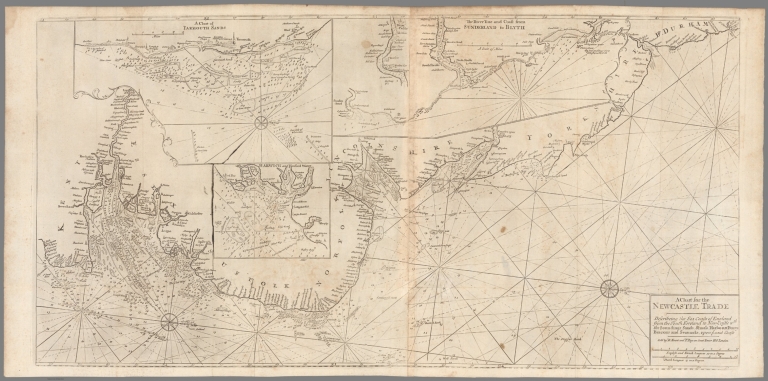
Full Title
A chart for the Newcastle trade describeing the sea coasts of England from the south foreland to New-Castle wth. the soundings, sands, shoals, harbours, buoys, beacons and seamarks upon the said coast. Sold by R. Mount and T. Page, London. (to accompany) The English pilot for the Southern navigation .... London : Printed for J. Mount and T. Page, on Tower Hill. M,DCC,LII (1752).
List No
13251.009
Note
Folded engraved navigation chart of Eastern England, with 3 insets: A Chart of Yarmouth Sands -- The River Tine and coast from Sunderland to Blyth -- Harwich and Hanford Water. Includes compass rose. Depths shown by soundings. Showing the course of the principal tracts and their distances from place to place.
Author
[Mount, John, Page, Thomas, 1704-1762, Mount and Page]
Full Title
(Text Page to) To Sail between Orford-ness and Burnham. (to accompany) The English pilot for the Southern navigation .... London : Printed for J. Mount and T. Page, on Tower Hill. M,DCC,LII (1752).
List No
13251.010
Note
Descriptive text. Includes 11 woodcut coastal profiles, showing churches and castles. Relief shown pictorially. Depth shown by soundings.
Author
[Mount, John, Page, Thomas, 1704-1762, Mount and Page]
Full Title
(Text Page to) To Sail between Orford-ness and Burnham. (to accompany) The English pilot for the Southern navigation .... London : Printed for J. Mount and T. Page, on Tower Hill. M,DCC,LII (1752).
List No
13251.011
Note
Descriptive text. Includes 11 woodcut coastal profiles, showing churches and castles. Relief shown pictorially. Depth shown by soundings.
Author
[Mount, John, Page, Thomas, 1704-1762, Mount and Page]
Full Title
(Text Page to) To Sail between Orford-ness and Burnham. (to accompany) The English pilot for the Southern navigation .... London : Printed for J. Mount and T. Page, on Tower Hill. M,DCC,LII (1752).
List No
13251.012
Note
Descriptive text. Includes 11 woodcut coastal profiles, showing churches and castles. Relief shown pictorially. Depth shown by soundings.
Author
[Mount, John, Page, Thomas, 1704-1762, Mount and Page]
Full Title
A new chart of the sea coast of Scotland with the islands thereof. Sold by W. & J. Mount and T. Page, London. (to accompany) The English pilot for the Southern navigation .... London : Printed for J. Mount and T. Page, on Tower Hill. M,DCC,LII (1752).
List No
13251.013
Note
Engraved folded navigation chart of cost of Scotland, with inset: A plan of Holy Island and Staples. Depths shown by soundings. Showing the course of the principal tracts from place to place. Includes Compass rose and rhimblines.
Author
[Mount, John, Page, Thomas, 1704-1762, Mount and Page]
Full Title
(Text Page to) To sail between Flamborough-Head and Berwick. A Description of the East-Coast of Scotland, From Berwick to Bokannais. (to accompany) The English pilot for the Southern navigation .... London : Printed for J. Mount and T. Page, on Tower Hill. M,DCC,LII (1752).
List No
13251.014
Note
Descriptive text of North coast of England and East coast of Scotland.
Author
[Mount, John, Page, Thomas, 1704-1762, Mount and Page]
Full Title
(Text Page to) To sail between Flamborough-Head and Berwick. A Description of the East-Coast of Scotland, From Berwick to Bokannais. (to accompany) The English pilot for the Southern navigation .... London : Printed for J. Mount and T. Page, on Tower Hill. M,DCC,LII (1752).
List No
13251.015
Note
Descriptive text of North coast of England and East coast of Scotland.
Author
[Mount, John, Page, Thomas, 1704-1762, Mount and Page]
Full Title
(Text Page to) To sail between Flamborough-Head and Berwick. A Description of the East-Coast of Scotland, From Berwick to Bokannais. (to accompany) The English pilot for the Southern navigation .... London : Printed for J. Mount and T. Page, on Tower Hill. M,DCC,LII (1752).
List No
13251.016
Note
Descriptive text of North coast of England and East coast of Scotland.
Author
[Mount, John, Page, Thomas, 1704-1762, Mount and Page]
Full Title
(Text Page to) A Description of the Coast of Flanders and the Flemitsh Banks. (to accompany) The English pilot for the Southern navigation .... London : Printed for J. Mount and T. Page, on Tower Hill. M,DCC,LII (1752).
List No
13251.017
Note
Descriptive text of the Coast of Flanders.
Author
[Mount, John, Page, Thomas, 1704-1762, Mount and Page]
Full Title
(Text Page to) A Description of the Coast of Flanders and the Flemitsh Banks. (to accompany) The English pilot for the Southern navigation .... London : Printed for J. Mount and T. Page, on Tower Hill. M,DCC,LII (1752).
List No
13251.018
Note
Descriptive text of the Coast of Flanders. Includes coastal profiles.
Author
[Mount, John, Page, Thomas, 1704-1762, Mount and Page]
Full Title
(Text Page to) A Description of the Coast of Flanders and Zealand. A description of the Channels of Teer-Veer, Zierickzee, and Brewers-Haven. (to accompany) The English pilot for the Southern navigation .... London : Printed for J. Mount and T. Page, on Tower Hill. M,DCC,LII (1752).
List No
13251.019
Note
Descriptive text of the Coast of Zealand.
Author
[Mount, John, Page, Thomas, 1704-1762, Mount and Page]
Full Title
A chart of the seacoasts of England, Flanders & Holland. Shewing all the sands, shoals, rocks and dangers, the bayes, roads, harbours, buoyes, beacons and seamarks on the said coasts. Sold by W. & J. Mount and T. Page, London. (to accompany) The English pilot for the Southern navigation .... London : Printed for J. Mount and T. Page, on Tower Hill. M,DCC,LII (1752).
List No
13251.020
Note
Engraved double page navigation chart. Depths shown by soundings. Showing the course of the principal tracts from place to place. Includes Compass rose and rhimblines.
Author
[Mount, John, Page, Thomas, 1704-1762, Mount and Page]
Full Title
(Text Page to) A Description of the Coast of Flanders and Zealand. A description of the Channels of Goerees-Gat and Maes. (to accompany) The English pilot for the Southern navigation .... London : Printed for J. Mount and T. Page, on Tower Hill. M,DCC,LII (1752).
List No
13251.021
Note
Descriptive text of the Coast of Zealand and A description of the Channels of Goerees-Gat and Maes.. Includes 2 coastal profiles.
Author
[Mount, John, Page, Thomas, 1704-1762, Mount and Page]
Full Title
(Text Page to) A Description of the Coast of Flanders and Zealand. A description of the Channels of Goerees-Gat and Maes. (to accompany) The English pilot for the Southern navigation .... London : Printed for J. Mount and T. Page, on Tower Hill. M,DCC,LII (1752).
List No
13251.022
Note
Descriptive text of the Coast of Hollands Includes coastal profiles.
Author
[Mount, John, Page, Thomas, 1704-1762, Mount and Page]
Full Title
(Text Page to) A Description of the Coast of Flanders and Zealand. A description of the Channels of Goerees-Gat and Maes. (to accompany) The English pilot for the Southern navigation .... London : Printed for J. Mount and T. Page, on Tower Hill. M,DCC,LII (1752).
List No
13251.023
Note
Descriptive text of the Coast of Hollands Includes coastal profiles.
Author
[Mount, John, Page, Thomas, 1704-1762, Mount and Page]
Full Title
(Text Page to) A description of the Coast of England, from the River Thames to Downs, and from Tence to Westwrd. (to accompany) The English pilot for the Southern navigation .... London : Printed for J. Mount and T. Page, on Tower Hill. M,DCC,LII (1752).
List No
13251.024
Note
Descriptive text of the Coast England.
Author
[Mount, John, Page, Thomas, 1704-1762, Mount and Page]
Full Title
(Text Page to) A description of the Coast of England, from the River Thames to Downs, and from Tence to Westwrd. (to accompany) The English pilot for the Southern navigation .... London : Printed for J. Mount and T. Page, on Tower Hill. M,DCC,LII (1752).
List No
13251.025
Note
Descriptive text of the Coast England.
Author
[Mount, John, Page, Thomas, 1704-1762, Mount and Page]
Full Title
(Text Page to) A description of the Coast of England, from the River Thames to Downs, and from Tence to Westwrd. (to accompany) The English pilot for the Southern navigation .... London : Printed for J. Mount and T. Page, on Tower Hill. M,DCC,LII (1752).
List No
13251.026
Note
Descriptive text of the Coast England.
Author
[Mount, John, Page, Thomas, 1704-1762, Mount and Page]
Full Title
A new chart of England, Scotland and Ireland. Sold by W. & J. Mount and T. Page, London. (to accompany) The English pilot for the Southern navigation .... London : Printed for J. Mount and T. Page, on Tower Hill. M,DCC,LII (1752).
List No
13251.027
Note
Engraved double page navigation chart. Depths shown by soundings. Showing the course of the principal tracts from place to place. Includes Compass rose, Title cartuche and coat of arms. "A Scale of English & French Leagues".
Author
[Mount, John, Page, Thomas, 1704-1762, Mount and Page]
Full Title
(Text Page to) Directions between Plymouth and Falmouth. (to accompany) The English pilot for the Southern navigation .... London : Printed for J. Mount and T. Page, on Tower Hill. M,DCC,LII (1752).
List No
13251.028
Note
Descriptive text of the Coast England. Includes profiles.
Author
[Mount, John, Page, Thomas, 1704-1762, Mount and Page]
Full Title
(Text Page to) Directions between Plymouth and Falmouth. Directions from the Isle of Wight to Portland. (to accompany) The English pilot for the Southern navigation .... London : Printed for J. Mount and T. Page, on Tower Hill. M,DCC,LII (1752).
List No
13251.029
Note
Descriptive text of the Coast England. Includes profiles.
Author
[Mount, John, Page, Thomas, 1704-1762, Mount and Page]
Full Title
(Text Page to) Directions between Portland and the Lizrd. (to accompany) The English pilot for the Southern navigation .... London : Printed for J. Mount and T. Page, on Tower Hill. M,DCC,LII (1752).
List No
13251.030
Note
Descriptive text of the Coast England.
Author
[Mount, John, Page, Thomas, 1704-1762, Mount and Page]
Full Title
(Text Page to) Directions between Plymouth and Falmouth. (to accompany) The English pilot for the Southern navigation .... London : Printed for J. Mount and T. Page, on Tower Hill. M,DCC,LII (1752).
List No
13251.031
Note
Descriptive text of the Coast England.
Author
[Mount, John, Page, Thomas, 1704-1762, Mount and Page]
Full Title
(Text Page to) Directions between Plymouth and Falmouth. (to accompany) The English pilot for the Southern navigation .... London : Printed for J. Mount and T. Page, on Tower Hill. M,DCC,LII (1752).
List No
13251.032
Note
Descriptive text of the Coast England. Includes coastal profiles.
Author
[Mount, John, Page, Thomas, 1704-1762, Mount and Page]
Full Title
(Text Page to) Directions between Lizard and Isles of Scilly. (to accompany) The English pilot for the Southern navigation .... London : Printed for J. Mount and T. Page, on Tower Hill. M,DCC,LII (1752).
List No
13251.033
Note
Descriptive text of the Coast England.
Author
[Mount, John, Page, Thomas, 1704-1762, Mount and Page]
Full Title
A new chart of British Channel. Extending from north foreland to Scilly Isles &c. on the English shore and from Dunkirk to Ushent on the French . Collected from accurate surveys ... by Cpt. Edmd. Halley. Sold by W. & J. Mount and T. Page, London. (to accompany) The English pilot for the Southern navigation .... London : Printed for J. Mount and T. Page, on Tower Hill. M,DCC,LII (1752).
List No
13251.034
Note
Engraved folded navigation chart, with 9 inset profiles. Depths shown by soundings. Showing the course of the principal tracts from place to place. Includes notes, advertisement, compass roses and Title cartouche.
Author
[Mount, John, Page, Thomas, 1704-1762, Mount and Page]
Full Title
(Text Page to) Directions for the Coast of France. A description of the Coast of France from Calais to the River Roan. (to accompany) The English pilot for the Southern navigation .... London : Printed for J. Mount and T. Page, on Tower Hill. M,DCC,LII (1752).
List No
13251.035
Note
Descriptive text of the Coast France.
Author
[Mount, John, Page, Thomas, 1704-1762, Mount and Page]
Full Title
(Text Page to) Directions for the Coast of France. A description of the Coast of France from Calais to the River Roan. (to accompany) The English pilot for the Southern navigation .... London : Printed for J. Mount and T. Page, on Tower Hill. M,DCC,LII (1752).
List No
13251.036
Note
Descriptive text of the Coast France.
Author
[Mount, John, Page, Thomas, 1704-1762, Mount and Page]
Full Title
(Text Page to) Directions for the Coast of France. A description of the Coast of Normandy ... (to accompany) The English pilot for the Southern navigation .... London : Printed for J. Mount and T. Page, on Tower Hill. M,DCC,LII (1752).
List No
13251.037
Note
Descriptive text of the Coast France. Includes coastal profiles.
Author
[Mount, John, Page, Thomas, 1704-1762, Mount and Page]
Full Title
(Text Page to) Directions for the Coast of France. (to accompany) The English pilot for the Southern navigation .... London : Printed for J. Mount and T. Page, on Tower Hill. M,DCC,LII (1752).
List No
13251.038
Note
Descriptive text of the Coast France. Includes coastal profiles.
Author
[Mount, John, Page, Thomas, 1704-1762, Mount and Page]
Full Title
(Text Page to) Directions for the Coast of France. (to accompany) The English pilot for the Southern navigation .... London : Printed for J. Mount and T. Page, on Tower Hill. M,DCC,LII (1752).
List No
13251.039
Note
Descriptive text of the Coast France.
Author
[Mount, John, Page, Thomas, 1704-1762, Mount and Page]
Full Title
(Text Page to) Directions for the Coast of France. (to accompany) The English pilot for the Southern navigation .... London : Printed for J. Mount and T. Page, on Tower Hill. M,DCC,LII (1752).
List No
13251.040
Note
Descriptive text of the Coast France.
Author
[Mount, John, Page, Thomas, 1704-1762, Mount and Page]
Full Title
(Text Page to) A Description of the West-Coast of England from the Land's-end to the Isle of Man. (to accompany) The English pilot for the Southern navigation .... London : Printed for J. Mount and T. Page, on Tower Hill. M,DCC,LII (1752).
List No
13251.041
Note
Descriptive text of the West coast of England.
Author
[Mount, John, Page, Thomas, 1704-1762, Mount and Page]
Full Title
(Text Page to) A Description of the West-Coast of England from the Land's-end to the Isle of Man. (to accompany) The English pilot for the Southern navigation .... London : Printed for J. Mount and T. Page, on Tower Hill. M,DCC,LII (1752).
List No
13251.042
Note
Descriptive text of the West coast of England and coast of Wales.
Author
[Mount, John, Page, Thomas, 1704-1762, Mount and Page]
Full Title
(Text Page to) A Description of the West-Coast of England from the Land's-end to the Isle of Man. (to accompany) The English pilot for the Southern navigation .... London : Printed for J. Mount and T. Page, on Tower Hill. M,DCC,LII (1752).
List No
13251.043
Note
Descriptive text of the West coast of England and coast of Chester and Liverpool.
Author
[Mount, John, Page, Thomas, 1704-1762, Mount and Page]
Full Title
A chart of the coasts of Ireland and part of England . Sold by Willm. Mount and Thos. Page, London. (to accompany) The English pilot for the Southern navigation .... London : Printed for J. Mount and T. Page, on Tower Hill. M,DCC,LII (1752).
List No
13251.044
Note
Engraved double page navigation chart. Depths shown by soundings. Showing the course of the principal tracts from place to place. compass roses.
Author
[Mount, John, Page, Thomas, 1704-1762, Mount and Page]
Full Title
The channel and city of Dublin . The County of Waterford. Wexfor County. County of Wicklow. (to accompany) The English pilot for the Southern navigation .... London : Printed for J. Mount and T. Page, on Tower Hill. M,DCC,LII (1752).
List No
13251.045
Note
2 engraved double page navigation chart on 1 sheet. Depths shown by soundings. Showing the course of the principal tracts from place to place. compass roses.
|