Who What Where WhenWHATShow MoreWHEREShow More |
Author
Schedel, Hartmann (1440-1514)
Full Title
(Europe) Nuremberg Chronicle) Register DES BUCHS DER CRO=NICKEN und geschichten mit figure…
List No
15906.299
Note
"The map includes one of the earliest depictions of Scandinavia and the Baltic Coast, extending to Russia in the east and Ireland and England in the west. In the south, the map extends south of the Alps to Istanbul, Venice and the northernmost coast of the Mediterranean Sea. Schedel's map is a cartographic landmark. As noted by Ginsberg, Schedel's map is perhaps best characterized as: The first modern map of northern and central Europe. The map ranges from the British Isles to Constantinopel. The designer has been identified as Hieronymus Munzer (1437-1508), who trained as a physician . . . The Munzer map is one of the earliest to depict the Scandinavia peninsula. Nordenskold credits the map of the north in the Zamoyski codes as the prototype for this map. The source for the Central European portion is a manuscript ma circa 1460 of Germany by Cardinal Nicolas Cusanus, printed posthumously at Eystatt in 1491." (Ruderman, 2021)
Author
[Ptolemy, Claudius, Gastaldi, Giacomo, Mattioli, Pietro Andrea, 1500-1577, Pedrezano, Giovanbattista]
Full Title
Tabula Aphricae II. (to accompany) Ptolemeo. La geografia di Claudio Ptolemeo alessandrino ... In Venetia, ... per Gioan. Baptista Pedrezano ... Anni x. M.D.XLVIII (1548).
List No
11479.067
Note
Engraved ancient map of part of North Africa and part of the Mediterranean, including Sardinia and Sicily. Shows cities, towns, landmarks, rivers and mountains. Relief shown pictorially.
Author
[Ptolemy, Claudius, Gastaldi, Giacomo, Mattioli, Pietro Andrea, 1500-1577, Pedrezano, Giovanbattista]
Full Title
Tabula Asiae IIII. (to accompany) Ptolemeo. La geografia di Claudio Ptolemeo alessandrino ... In Venetia, ... per Gioan. Baptista Pedrezano ... Anni x. M.D.XLVIII (1548).
List No
11479.091
Note
Engraved ancient map of Eastern Mediterranean and the Middle East from Cyprus to Babylonia. Shows settlements, towns, landmarks, rivers and mountains. Relief shown pictorially.
Author
[Ptolemy, Claudius, Ruscelli, Girolamo, Giuseppe Moletti, M.]
Full Title
Tabvla Asiae IIII. Dell' Asia,Tavola Qvarta antica. (To accompany) La geografia di Claudio Tolomeo Alessandrino, nuouamente tradotta di Greco in Italiano, da Girolamo Ruscelli ... In Venetia, Appresso Vincenzo Valgrisi, M.D.LXI. (1561).
List No
11311.044
Note
Engraved map of the Eastern Mediterranean and the Middle East from Cyprus to Babylonia. Relief shown pictorially.
Author
Lafreri, Antonio, 1512-1577
Full Title
Disegno dell Isola di Malta con li porti et forti… In Roma per Antonio Lafreri nel anno 1565…
List No
16005.000
Author
Monte (Monti), Urbano, 1544-1613
Full Title
Tavola Quinta, Che Ha Sua Superiore La Tavola Prima. Libro Terzo.
List No
10130.007
Note
The note box has been cut out, indicating perhaps an intended revision that did not occur.
Author
Bunting, Heinrich
Full Title
Die eigentliche und warhafftige gestalt der Erden und des Meers
List No
15301.004
Note
"Striking Early World Map with Apocryphal Appearance of the West Coast of Australia Decorative example of Heinrich Bunting's unusual map of the known world: Europe, Africa, much of Asia, the tip of the Americas, and the Indian Ocean. It depicts the fast-changing geography of the sixteenth century, which was being altered by the European voyages to the Americas and beyond. Shirley refers to Bunting’s “strange geographic license;” indeed, his woodcut maps are often unique representations with few predecessors or descendants; for this reason they would make a special part of collections of world maps or biblical maps. This license stems in part from Bunting’s purpose. As a theologian, not a geographer, he sought to use the maps as illustrations of the movements of biblical actors. This world map was included in Bunting’s Itinerarium Sacrae Scripturae, one of the bestselling books of the sixteenth century. Although the precise number and content of the maps in the volumes shifted over time, this map was included from the very first edition, published in Magdeburg in 1581. This interesting map focuses on the oikumene, or the ancient known world, showing Europe, Asia, and Africa in outline with the locations of the principal cities. However, these continents have been updated. For example, the Portuguese discoveries have been integrated as to the extent and shape of Africa. Additionally, America, the New World, peeps out of the western border, while a bit of the East Indies, shaped tantalizingly like Western Australia, are in the lower right corner. South of the Indian subcontinent is a large island labeled Taprobana. Taprobana was what the Greeks had called Sri Lanka, but late-medieval and early modern geographers also applied the toponym to Sumatra and a phantom island. Here Bunting seems to follow the Greek example. At sea, several sea monsters patrol the waters. In Africa, the Nile originates from tributaries in the Montes Lunae, or Mountains of the Moon. While this follows the conventional model set out by Ptolemy, Bunting has improvised with the placement of the large lake attached to the Nile. Contemporaries like Ortelius, himself following Gastaldi, also believed a large central lake fed the great rivers of Africa, including the Nile. However, they placed this lake in far southern Africa. Bunting is nearly unique in putting his lake father north. While the main cities are placed in the Middle East, closer to the epicenter of biblical events, it is in Africa where Bunting seems to have added the most detail. In northern Africa, he includes the label, Der wiessen Moren, or the White Moors, while farther south is Der Schwartzen Morenland, Land of the Black Moors. He has been sure to include Meroe in the center of a large island in the Nile River. This refers to the mythical tombs of the Nubian Kings. Just southeast of Meroe is the kingdom of Prester John, the famed Christian King was thought of as a hero for holding out against the Muslims who surrounded him. An Early Appearance of the West Coast of Australia? Bunting's map charts a landmass, India Meridionalis, in the far southeast of the Indian Ocean. To modern eyes, it strikingly resembles Australia's west coast. Shown to be in roughly the correct position of Australia, its presence is thought by some to indicate the possible Portuguese knowledge of Australia prior to the Dutch discovery in 1606. However, this theory has not been widely accepted and the more likely explanation is that the land mass is either a depiction of the southern part of the Malay Peninsula, based upon maps such at those by Martellus and Cantino, or perhaps Tierra del Fuego, as described in Tramezzino's world map. This map contains several interesting geographic constructions and is a strikingly original representation of the sixteenth-century world. It would make a significant contribution to collections of African, world, biblical, or early Americas maps." (Ruderman, 2022)
Author
Bunting, Heinrich
Full Title
Asia Secunda Pars Terrae in Forma Pegasir [Asia in the Form of Pegasus]
List No
15301.006
Note
"Bunting's map of Asia in the shape of the mythical winged horse Pegasus is among the earliest cartographic representations. The horse is drawn fairly realistically, with a good deal of imagination required to view the map. The head represents Asia Minor with the mouth at Istanbul. The wings portray Central Asia and Siberia. The Caspian Sea appears horizontally between the wings and the saddle. Persia is delineated on the horse blanket with the forelegs forming Arabia. The hind legs represent the Indian and Malay peninsulas." (Ruderman, 2022)
Author
Bunting, Heinrich
Full Title
Africa Tertia Pars Terræ
List No
15301.007
Note
"Rich dark example of Heinrich Bunting's scarce map of Africa, from a German edition of his Itinerarium Sacræ Scripturæ. The Nile finds its source in the mountains of the moon. Elephantophagi is shown in West Africa. Several large cities and kingdoms noted. The map is based largely upon Munter's map, first issued in 1540. Large sailing ship and sea creatures embellish the map." (Ruderman, 2022)
Author
Bunting, Heinrich
Full Title
Reisen der Kinder von Israel aus Egypten
List No
15301.010
Note
"This detailed map shows the route taken by the Israelites in the Exodus from Egypt to the Promised Land. The map is very graphic with a vignette of the Pharaoh drowning in the Red Sea and Jonah on the back of a whale in the Mediterranean. The map extends from Jerusalem and Median in the east to Babylon, Memphis and most of the Nile River Delta in the west. This scarce map is from Heinrich Bunting's Itinerarum Sacrae Scripturae. It is believed that more than 60 editions of Bunting's Itinerarum were published in various languages between 1581 and 1757. Bunting's work describes the travels of religious figures in the Bible and was the most complete summary of geography of the Bible of this period. Itinerarum Sacrae Scripturae was first printed in Helmstadt in 1581 and was produced in numerous editions in Germany. The book was so popular, it was also issued with text in Danish, Swedish, Dutch, Czech, and English." (Ruderman, 2022)
Author
Bunting, Heinrich
Full Title
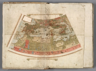
[Bunting's Map of the Mediterranean Region]
List No
15301.013
Note
"Map of the Mediterranean region, from Heinrich Bunting's Itinerarium Saccrae Scripturae first published in 1581. The map shows the Eastern Mediterranean, including Sicily, Malta, Cyprus, Rome, the Holy Land, Alexandria, the southern Black Sea, Constantinople, Greece, Asia Minor, Armenia, etc. Sea Monster shown in the Mediterranean. "(Ruderman, 2022)
Author
[Ptolemy, Claudius, Ruscelli,Girolamo, Rosaccio, Giuseppe]
Full Title
Tabvla Asiae IIII. Della Geografia di Tolomeo. Libro Quinto. (to accompany) Geographia di Clavdio Tolomeo alessandrino, tradotta di Greco nell'idioma volgare Italiano da Girolamo Ruscelli ... In Venetia, MDXCIX (1599) Appresso gli heredi di M. Sessa.
List No
11299.024
Note
Engraved map of the Eastern Mediterranean and the Middle East from Cyprus to Babylonia. Relief shown pictorially.
Author
[Mercator, Gerhard, 1512-1594, Hondius, Iodocus, 1563-1612]
Full Title
Turcicum Imperium. (to accompany) Atlas minor Gerardi Mercatoris.
List No
11201.419
Note
Map of Turkish Empire, the Arabian peninsula and eastern part of the Mediterranean. Relief shown pictorially.
Author
[Mercator, Gerhard, 1512-1594, Hondius, Iodocus, 1563-1612]
Full Title
Paradisus. (to accompany) Atlas minor Gerardi Mercatoris.
List No
11201.467
Note
Map showing the Holy Land between the Mediterranean and Chaldea in present-day Iraq, extending to the mouth of the Tigris in the Persian Gulf. The map depicts the site of Paradise, between the four rivers near Babylon. At bottom is a large vignette of Adam and Eve below the apple tree in Paradise.
Author
[Mercator, Gerhard, 1512-1594, Hondius, Iodocus, 1563-1612]
Full Title
Peregrinatio Pauli : in qua & omnia loca quorum fit mentio in actis et epistolis apostolorum et apocalypsi describuntur. (to accompany) Atlas minor Gerardi Mercatoris.
List No
11201.473
Note
Map showing the travels of St. Paul between Rome and Jerusalem. Including Greece, Crete, Turkey, Palestine and Cyprus. Includes text. Relief shown pictorially.
Author
[Mercator, Gerhard, 1512-1594, Hondius, Iodocus, 1563-1612]
Full Title
Aeneae Troiani Navigatio. (to accompany) Atlas minor Gerardi Mercatoris.
List No
11201.479
Note
Map of the eastern part of the Mediterranean depicting the journey of Aeneas from Phrygia (Turkey) to Rome. Relief shown pictorially.
Author
[Ortelius, Abraham, 1527-1598, Vrients, Jan Baptista]
Full Title
Candia Insula (with) Archipelagi Insularum Aliquot Descrip.
List No
10001.278
Note
11 maps on 1 plate. Shows Crete and 10 island in the Mediterranean Sea.
Author
[Ortelius, Abraham, 1527-1598, Vrients, Jan Baptista]
Full Title
Aeneae Troiani Navigatio. Ad Virgilii sex priores Aeneidos. Cum privilegio Imperatorio, Regio, et Cancellariae Brabantiae, decennali. 1594.
List No
10001.422
Note
Part of the Parergon.
Author
Blaeu, Willem Janszoon, 1571-1638
Full Title
(Covers to) Licht der Zeevaert.
List No
14351.001
Note
Covers to Het Licht der Zee-vaert. Calf binding with richly gilded spine compartments and title. Title translates (loosely) to: Light of the sea.
Author
Blaeu, Willem Janszoon, 1571-1638
Full Title
(Title Page to) Het Licht der Zee-vaert daerinne claersyck beschreven ende afghebeeldet werdé, alle de Custen end Havenen; vande Westersche, Noordsche, Oostersche ende Middelandsche Zee'n. Dock van vele Landen, Eylanden ende plaetsen van Guinea, Brasilien, Oost ende West-Indien. Wt de alderbeste Zeebeschryvers gheschriften (als Locas Ians z. Waghenaer ende meer andere) eenfdeels vergadert: maer uyt vele ervarene Zeevaerders schriften ende mondtlycke verclaringhen van alle verlopen ghebetert, ende met veel nieuwe beschryvinghen ende Caerten seer vermeerdert. Alles ghedeelt in vier boecken, waer van yders inhoudt voor elck uytghedruckt staet. Hier zyn byghevoeght (beneffens eene onderwysinghe in de conste der Zeevaert) nieuwe tafelen van der zonnen declinatie, gherekent uyt de observation van Tyche Brahe, ende gherecht op de Meridiaen van Amsterdam. Midsgaders nieuwe tafelenende onderwys van't recht ghebruyck der Noordsterre ende andere vaste sterren alle Zeevarende luyden te nut ghedaen. Door Willem Ians Zoon. Tot Amsterdam. Anno 1620.
List No
14351.002
Note
Title page to Het Licht der Zee-vaert. Includes an engraved illustration of two figures, as well as a view showing the port of Amsterdam. Title translates (loosely) to: The Light of the Sea, which is described and depicted; all the coasts and the ports of the Western, Northern, Eastern and Mediterranean Seas. Docks of many countries, islands and the places of Guinea, Brazil, East and the West Indies. With the best sea writings … with many new descriptions … Everything is divided into four books … Here are new tables of the sun’s declination, based on the observation of Tyche Brahe …
Author
[Blaeu, Willem Janszoon, 1571-1638, Hooft, P. C. (Pieter Corneliszoon), 1581-1647]
Full Title
(Text Page to) Klinkckdicht, op her licht der zeevaert. Z. H. -- Op het licht der zeevaert. P. C. Hooft.
List No
14351.003
Note
Two introductory texts to Het Licht der Zee-vaert. Second page includes an engraved lion. Titles translate (loosely) to: In the light of the seafarer.
Author
Blaeu, Willem Janszoon, 1571-1638
Full Title
[View of seafarers].
List No
14351.004
Note
View showing a group of men using globes, maps and other tools to chart navigational plans, with a roiling sea in the background, sailed by numerous vessels. Black and white engraving. View is 23 x 27 cm, on sheet 26 x 29 cm. (Title supplied by cataloger.)
Author
Blaeu, Willem Janszoon, 1571-1638
Full Title
(Text Page to) Loste ende clare Inleydinghe tot het verstrent de Hemelsche Sphera, in soo veele, als tot de conste der Zeebaert van noode is. (1)
List No
14351.005
Note
First section to Het Licht der Zee-vaert. Title translates (loosely) to: To the farthest end of the celestial sphere ... Includes chapter: I. Van de Polen der Werelt [= Of the poles of the world]. With historiated initial. Features engraved diagram showing the earth on its axis.
Author
Blaeu, Willem Janszoon, 1571-1638
Full Title
(Text Page to) Loste ende clare Inleydinghe tot het verstrent de Hemelsche Sphera, in soo veele, als tot de conste der Zeebaert van noode is. (2)
List No
14351.006
Note
First section to Het Licht der Zee-vaert. Title translates (loosely) to: To the farthest end of the celestial sphere ... Includes chapters: Capittel II. Van de Linie Æquinoetiael [= Equinoctial line]. -- Capittel III. Vande Tropicken en den Zodiac [= Lines of the tropics and the zodiac]. Features engraved diagram showing the earth on its axis, along with the zodiac positions.
Author
Blaeu, Willem Janszoon, 1571-1638
Full Title
Caarte Vande Reede ende Haven van Medenblick, hoemen die ... Anno 1614.
List No
14351.007
Note
Nautical chart showing the harbor of Medemblick (Netherlands). Features cities, roads, ports, coastline, shoals, islands, anchorage, soundings and ships. Relief shown pictorially. Includes rhumb lines and compass roses, with north oriented toward lower right. Decorative cartouches. Black and white engraving. Chart is 25 x 55 cm, on double sheet 26 x 58 cm.
Author
Blaeu, Willem Janszoon, 1571-1638
Full Title
(Text Page to) Loste ende clare Inleydinghe tot het verstrent de Hemelsche Sphera, in soo veele, als tot de conste der Zeebaert van noode is. (3)
List No
14351.008
Note
First section to Het Licht der Zee-vaert. Title translates (loosely) to: To the farthest end of the celestial sphere ... Includes chapters: Capittel III. Vande Tropicken en den Zodiac [= Lines of the tropics and the zodiac]. -- Capittel IV. Van den loop der Sonnen [= Course of the Sun] -- Capittel V. Van de declinatie der Sonnen [= Declination of the Sun].
Author
Blaeu, Willem Janszoon, 1571-1638
Full Title
(Text Page to) Loste ende clare Inleydinghe tot het verstrent de Hemelsche Sphera, in soo veele, als tot de conste der Zeebaert van noode is. (4)
List No
14351.009
Note
First section to Het Licht der Zee-vaert. Title translates (loosely) to: To the farthest end of the celestial sphere ... Includes chapter: Capittel VI. Hoemen alle daghen de declinatie des Sons vinden sal [= How every day they find the declination of the Sun]. Features engraved illustration of the sun.
Author
Blaeu, Willem Janszoon, 1571-1638
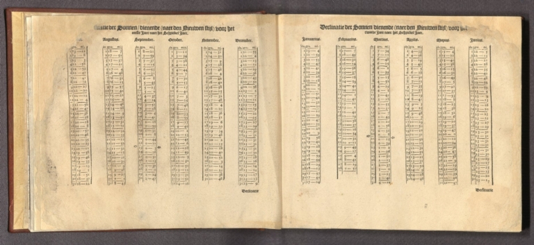
Full Title
(Text Page to) Declinatie der Sonnen ... (1)
List No
14351.010
Note
Table within Het Licht der Zee-vaert. Title translates (loosely) to: Declination of the Sun. Covers the months of January through June, with figures recorded for each date. Includes manicules pointing out the spring equinox in the calendar.
Author
Blaeu, Willem Janszoon, 1571-1638
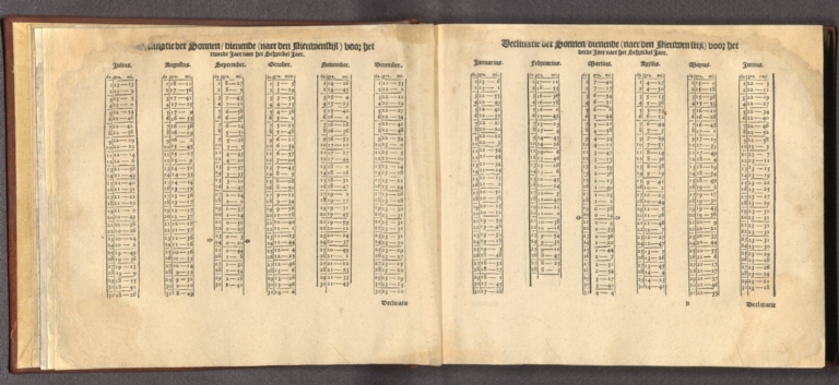
Full Title
(Text Page to) Declinatie der Sonnen ... (2)
List No
14351.011
Note
Table within Het Licht der Zee-vaert. Title translates (loosely) to: Declination of the Sun. Covers the months of July through June, with figures recorded for each date. Includes manicules pointing out both the autumnal and spring equinoxes in the calendar.
Author
Blaeu, Willem Janszoon, 1571-1638
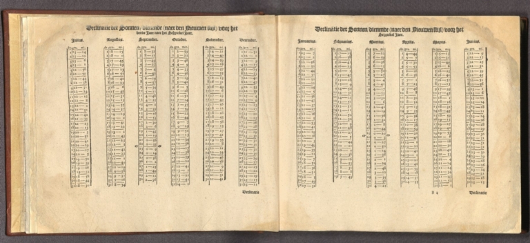
Full Title
(Text Page to) Declinatie der Sonnen ... (3)
List No
14351.012
Note
Table within Het Licht der Zee-vaert. Title translates (loosely) to: Declination of the Sun. Covers the months of July through June, with figures recorded for each date. Includes manicules pointing out both the autumnal and spring equinoxes in the calendar.
Author
Blaeu, Willem Janszoon, 1571-1638
Full Title
(Text Page to) Declinatie der Sonnen ... (4)
List No
14351.013
Note
Table within Het Licht der Zee-vaert. Title translates (loosely) to: Declination of the Sun. Covers the months of July through June, with figures recorded for each date. Includes manicules pointing out both the autumnal and spring equinoxes in the calendar.
Author
Blaeu, Willem Janszoon, 1571-1638
Full Title
(Text Page to) Declinatie der Sonnen ... (5)
List No
14351.014
Note
Table on the sun within Het Licht der Zee-vaert. Title translates (loosely) to: Declination of the Sun. Covers the months of July through June, with figures recorded for each date. Includes manicules pointing out the autumnal equinox in the calendar.
Author
Blaeu, Willem Janszoon, 1571-1638
Full Title
(Text Page to) Loste ende clare Inleydinghe tot het verstrent de Hemelsche Sphera, in soo veele, als tot de conste der Zeebaert van noode is. (5)
List No
14351.015
Note
First section to Het Licht der Zee-vaert. Title translates (loosely) to: To the farthest end of the celestial sphere ... Includes chapter: VII. Van de vaste Sterren, haer declinatie ende hoese in declinatie connen veranderen, mitsgaders aenwysinghe hoemense licht sal leeren kennen [= Of the fixed stars, their declension ... with knowledge of how much light falls].
Author
Blaeu, Willem Janszoon, 1571-1638
Full Title
(Text Page to) Tafel van de declinatie der fire. (1)
List No
14351.016
Note
Description of constellations within Het Licht der Zee-vaert. Title translates (loosely) to: Table of the declination of fire. Describes different constellations, with engraved views of those star arrangements. Includes "Bootes de Boer" [Boötes] and "Het Scorpioen" [Scorpio].
Author
Blaeu, Willem Janszoon, 1571-1638
Full Title
(Text Page to) Tafel van de declinatie der fire. (2)
List No
14351.017
Note
Description of constellations within Het Licht der Zee-vaert. Title translates (loosely) to: Table of the declination of fire. Describes different constellations, with engraved views of those star arrangements. Includes "Lyra" and "Andromeda".
Author
Blaeu, Willem Janszoon, 1571-1638
Full Title
(Text Page to) Tafel van de declinatie der fire. (3)
List No
14351.018
Note
Description of constellations within Het Licht der Zee-vaert. Title translates (loosely) to: Table of the declination of fire. Describes different constellations, with engraved views of those star arrangements. Includes "Aries" and "Taurus".
Author
Blaeu, Willem Janszoon, 1571-1638
Full Title
(Text Page to) Loste ende clare Inleydinghe tot het verstrent de Hemelsche Sphera, in soo veele, als tot de conste der Zeebaert van noode is. (6)
List No
14351.019
Note
First section to Het Licht der Zee-vaert. Title translates (loosely) to: To the farthest end of the celestial sphere ... Includes chapters: VIII. Hoemen tot alle tyden des jaers de uren des nachts vinden sal [= How to find the hours of the night ... ]. -- IX. Van den Horizon ofte Sicht-eynder [= Horizon line]. Features engraved diagram, as well as a calendar with the zodiac in the format of a vovelle, entitled, "De achterste wielen vanden grooten Wagen".
Author
Blaeu, Willem Janszoon, 1571-1638
Full Title
(Text Page to) Loste ende clare Inleydinghe tot het verstrent de Hemelsche Sphera, in soo veele, als tot de conste der Zeebaert van noode is. (7)
List No
14351.020
Note
First section to Het Licht der Zee-vaert. Title translates (loosely) to: To the farthest end of the celestial sphere ... Includes chapters: IX. Van den Horizon ofte Sicht-eynder [= Horizon line]. -- X. Van de Meridiaen ofte Middagh-Circkel [= Meridian line]. -- XI. Van de hooghte der Sonnen ofte Sterren, ende wat die is [= Height of the sun or stars]. -- XXI. Hoemen de hooghte van de Sonne ofte Sterren sal meten ende bevinden [= How to measure height of the sun or stars]. -- XIII. Hoemen eenen Graed-boghe perfeckelijcksal maecken ofte teeckenen [= How to draw ... ]. Features engraved diagrams showing astronomical observations.
Author
Blaeu, Willem Janszoon, 1571-1638
Full Title
(Text Page to) Loste ende clare Inleydinghe tot het verstrent de Hemelsche Sphera, in soo veele, als tot de conste der Zeebaert van noode is. (8)
List No
14351.021
Note
First section to Het Licht der Zee-vaert. Title translates (loosely) to: To the farthest end of the celestial sphere ... Includes chapter: XIII. Hoemen eenen Graed-boghe perfeckelijcksal maecken ofte teeckenen [= How to draw ... ]. Features engraved diagram showing astronomical observations, as well as a table.
Author
Blaeu, Willem Janszoon, 1571-1638
Full Title
(Text Page to) Loste ende clare Inleydinghe tot het verstrent de Hemelsche Sphera, in soo veele, als tot de conste der Zeebaert van noode is. (9)
List No
14351.022
Note
First section to Het Licht der Zee-vaert. Title translates (loosely) to: To the farthest end of the celestial sphere ... Includes chapters: XIV. van't vercorten der Graed-stocken, ende hoemen alle ghebreken der Graed-boghen helpen ende ghemoeten sal [= Of the corroboration of the "Graed-stock" ... ]. -- XV. Van de breedde der Landen [= Breadth of the lands]. -- XVI. Van de hooghte der Landen, ende wat die is [= Height of the lands]. Features engraved diagram showing astronomical observations.
Author
Blaeu, Willem Janszoon, 1571-1638
Full Title
(Text Page to) Loste ende clare Inleydinghe tot het verstrent de Hemelsche Sphera, in soo veele, als tot de conste der Zeebaert van noode is. (10)
List No
14351.023
Note
First section to Het Licht der Zee-vaert. Title translates (loosely) to: To the farthest end of the celestial sphere ... Includes chapters: XVI. Van de hooghte der Landen, ende wat die is [= Height of the lands] -- XVII. Hoemen de Polus hooghte sal vinden by de Sonne [= Height of the poles]. Features engraved diagram showing astronomical observations.
Author
Blaeu, Willem Janszoon, 1571-1638
Full Title
(Text Page to) Loste ende clare Inleydinghe tot het verstrent de Hemelsche Sphera, in soo veele, als tot de conste der Zeebaert van noode is. (11)
List No
14351.024
Note
First section to Het Licht der Zee-vaert. Title translates (loosely) to: To the farthest end of the celestial sphere ... Includes chapter: XVII. Hoemen de Polus hooghte sal vinden by de Sonne [= Height of the poles]. Features engraved diagrams showing astronomical observations.
Author
Blaeu, Willem Janszoon, 1571-1638
Full Title
(Text Page to) Loste ende clare Inleydinghe tot het verstrent de Hemelsche Sphera, in soo veele, als tot de conste der Zeebaert van noode is. (12)
List No
14351.025
Note
First section to Het Licht der Zee-vaert. Title translates (loosely) to: To the farthest end of the celestial sphere ... Includes chapters: XVII. Hoemen de Polus hooghte sal vinden by de Sonne [= Height of the poles]. -- XVIII. Hoemen de hooghte sal vinden by de Sterren [= Height of the stars]. Features engraved diagrams showing astronomical observations, as well as a table.
Author
Blaeu, Willem Janszoon, 1571-1638
Full Title
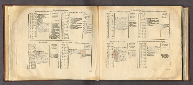
(Text Page to) Loste ende clare Inleydinghe tot het verstrent de Hemelsche Sphera, in soo veele, als tot de conste der Zeebaert van noode is. (13)
List No
14351.026
Note
First section to Het Licht der Zee-vaert. Title translates (loosely) to: To the farthest end of the celestial sphere ... Includes chapters: XVIII. Hoemen de hooghte sal vinden by de Sterren [= Height of the stars]. -- XIX. Vande Noord-sterre, ende hoemen de hooghte daer by sal vinden [= The North Star]. Features engraved diagram showing astronomical observations, as well as a table.
Author
Blaeu, Willem Janszoon, 1571-1638
Full Title
(Text Page to) Loste ende clare Inleydinghe tot het verstrent de Hemelsche Sphera, in soo veele, als tot de conste der Zeebaert van noode is. (14)
List No
14351.027
Note
First section to Het Licht der Zee-vaert. Title translates (loosely) to: To the farthest end of the celestial sphere ... Includes chapters: XIX. Vande Noord-sterre, ende hoemen de hooghte daer by sal vinden [= The North Star]. -- XX. Hoe veele mylen men op yeder streke moet seylen, eermen een graed in hooghte wint ofte verliest, oock hoe veel mijlen datmen alsdan is buyten den Meridiaen ofte Zuyd ende Noord-linie daermen afgheseylt is [= How many miles one has to sail in that area before one gains or loses a degree in height].
Author
Blaeu, Willem Janszoon, 1571-1638
Full Title
(Text Page to) Loste ende clare Inleydinghe tot het verstrent de Hemelsche Sphera, in soo veele, als tot de conste der Zeebaert van noode is. (15)
List No
14351.028
Note
First section to Het Licht der Zee-vaert. Title translates (loosely) to: To the farthest end of the celestial sphere ... Includes chapters: XXI. Wateen Stuerman meer van noode is te weten, met eene onderwysinghe aen alle jonghe Zee-varende luyden, die begeerich zijn om Stuermanschap te leeren [= What a seaman needs to know, with an education to all the young seafarers who are eager to learn seamanship]. -- XXII. Van de Water-ghetyden, hoemen die naer de Mane perfectelijck sal teeckenen [= From the waters .... ].
Author
Blaeu, Willem Janszoon, 1571-1638
Full Title
(Text Page to) Loste ende clare Inleydinghe tot het verstrent de Hemelsche Sphera, in soo veele, als tot de conste der Zeebaert van noode is. (16)
List No
14351.029
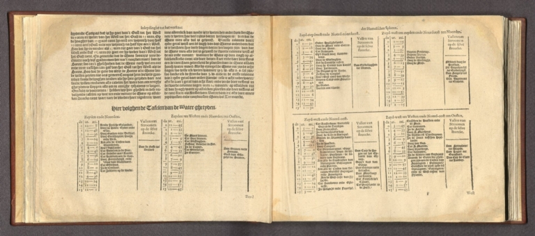
Note
First section to Het Licht der Zee-vaert. Title translates (loosely) to: To the farthest end of the celestial sphere ... Includes chapter: XXII. Van de Water-ghetyden, hoemen die naer de Mane perfectelijck sal teeckenen [= From the waters .... ]. With a table on water, entitled, "Hier volghen de Tafelen van de Water-ghetyden".
Author
Blaeu, Willem Janszoon, 1571-1638
Full Title
(Text Page to) Loste ende clare Inleydinghe tot het verstrent de Hemelsche Sphera, in soo veele, als tot de conste der Zeebaert van noode is. (17)
List No
14351.030
Note
First section to Het Licht der Zee-vaert. Title translates (loosely) to: To the farthest end of the celestial sphere ... With a table on water, entitled, "Hier volghen de Tafelen van de Water-ghetyden".
Author
Blaeu, Willem Janszoon, 1571-1638
Full Title
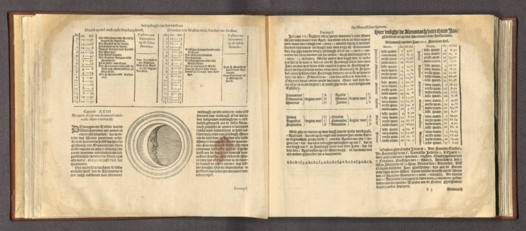
(Text Page to) Loste ende clare Inleydinghe tot het verstrent de Hemelsche Sphera, in soo veele, als tot de conste der Zeebaert van noode is. (18)
List No
14351.031
Note
First section to Het Licht der Zee-vaert. Title translates (loosely) to: To the farthest end of the celestial sphere ... With a table on water, entitled, "Hier volghen de Tafelen van de Water-ghetyden". Includes chapter: XXIII. Hoemen de tijt van de nieuwe ende volle Mane vinden sal [= How men will find the time of the new and the full moons]. Features engraved diagram of the moon, and an additional table.
Author
Blaeu, Willem Janszoon, 1571-1638
Full Title
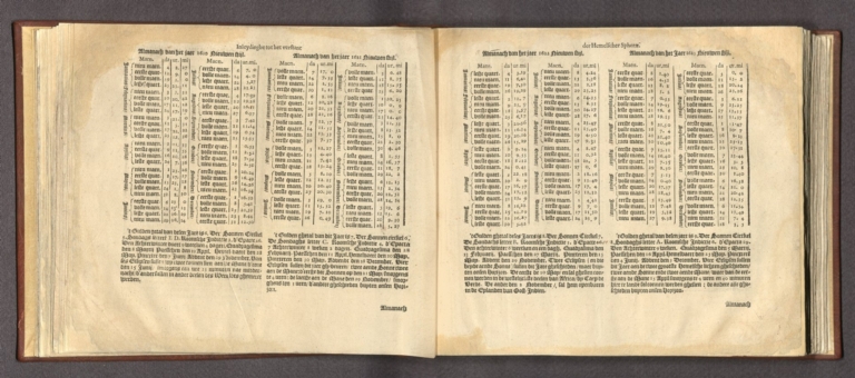
(Text Page to) Loste ende clare Inleydinghe tot het verstrent de Hemelsche Sphera, in soo veele, als tot de conste der Zeebaert van noode is. (19)
List No
14351.032
Note
First section to Het Licht der Zee-vaert. Title translates (loosely) to: To the farthest end of the celestial sphere ... Includes chapter: XXIII. Hoemen de tijt van de nieuwe ende volle Mane vinden sal [= How men will find the time of the new and the full moons]. With a table.
|



![Asia Secunda Pars Terrae in Forma Pegasir [Asia in the Form of Pegasus]](https://www.davidrumsey.com/rumsey/Size2/RUMSEY~8~1/199/15301006.jpg)


![[Bunting's Map of the Mediterranean Region]](https://www.davidrumsey.com/rumsey/Size2/RUMSEY~8~1/199/15301013.jpg)


![[View of seafarers].](https://www.davidrumsey.com/rumsey/Size2/RUMSEY~8~1/195/14351004.jpg)


