Who What Where WhenWHATShow More |
Author
[Allen, Paul, Biddle, Nicholas, Clark, William, Lewis, Meriwether]
Full Title
Fortification.
List No
3493.002
Note
Uncolored map showing remains of a fortification on the Missouri River.
Author
Melish, John
Full Title
(Northwestern Part only of) Map of the United States with the contiguous British & Spanish Possessions Compiled from the latest & best Authorities by John Melish. Engraved by J. Vallance & H.S. Tanner. Entered ... 16th day of June 1820. Published by James Finlayson Agent Philada. Successor to John Melish, Improved to 1823.
List No
5188.000
Note
This is an unusual survivor - in about 1854 someone cut out the Northwestern one third of John Melish's large Map of the United States (1823 edition) and updated it to show the states, territories and proposed territories of that period, notably Kansas and Nebraska but no Gadsden Purchase, and Shoshone and Dakota (which are usually seen on circa 1858-59 maps). The new boundaries are hand colored with white past down labels for names of states and territories. It might have been used as a school map in the west - we found it in a small town in the California gold country. This portion is dissected into 15 sections mounted on linen with silk edging, and folds down to 23x15.
Author
Vandermaelen, Philippe, 1795-1869
Full Title
Partie des Etats Unis. Amer. Sep. no. 40. Dessinee par H. Ghiesbreght. (Dresse par Ph. Vandermaelen, lithographie par H. Ode. Quatrieme partie. - Amer. sept. Bruxelles. 1827)
List No
2212.245
Note
Hand col. lithographed map. Relief shown by hachures. Shows Indians tribes with populations, route of Lewis and Clarke, etc. Covers parts of Montana, Wyoming, North and South Dakota and Nebraska.
Author
[Delavault, A., Vandermaelen, Philippe, 1795-1869]
Full Title
Parties des Etats-Unis et du Nouveau Mexique. Amer. Sep. no. 48. Dressee et dessinee par Ph. Vandermaelen. La lettre par Ph. Lippens. Desee. sur pierre et Lithie. par H. Ode, Avril 1825. (Quatrieme partie. - Amer. sept. Bruxelles. 1827)
List No
2212.253
Note
Hand col. lithographed map. Relief shown by hachures. Shows Indian tribes with populations. Covers parts of Colorado, Kansas, Nebraska, Texas, New Mexico and Oklahoma.
Author
Smith, J. Calvin
Full Title
Map Of The United States Of America Including Canada and a large portion of Texas: Showing the Base Meridian and Township Lines of the U.S. Surveys, The lands allotted to the Indian Tribes west of the Mississippi, The Various Internal Improvements &c. Compiled from surveys of the United States Land Office, and various other authentic sources. By J. Calvin Smith. New York, Published by Sherman & Smith, 122 Broadway. 1845. Entered ... 1843 by Geo. E. Sherman & J. Calvin Smith ... New York. Engraved and Printed by Sherman & Smith, New York ... (inset) Map Of North America By J. Calvin Smith. (inset) Southern Part Of Florida.
List No
0910.000
Author
[Breese, Samuel, 1802-1873, Gregg, Josiah, 1806-1850, Morse, Sidney E. (Sidney Edwards), 1794-1871]
Full Title
A map of the Indian Territory, northern Texas and New Mexico showing the great western prairies by Josiah Gregg. Entered ... 1844 by Sidney E. Morse and Samuel Breese ... New York. (New York: Published by Harper & Brothers, 1845)
List No
2301.030
Note
Col. wax engraved map. Relief shown by hachures. Covers also Kansas and parts of Colorado, Nebraska, Missouri and Iowa. Shows villages, Indian villages, ranchos, camps, springs, ruins, sandy regions, etc. Prime meridians: Greenwich and Washington.
Author
Sage, Rufus B.
Full Title
Map of Oregon, California, New Mexico, N.W. Texas & the proposed Territory of Ne-Bras-Ka. By Rufus B. Sage. 1846. F. Michelin's Lith. 111 Nassau St. N.Y.
List No
2299.001
Note
Map uncolored. Note in the area of present-day Nevada and Utah states, "This region has never been explored, and is supposed to be impassable on account of its immense plains of sand, alike destitute of vegetation and water."
Author
[Fremont, J.C., Preuss, Charles]
Full Title
Topographical Map Of The Road From Missouri To Oregon, Commencing At The Mouth Of The Kansas In The Missouri River And Ending At The Mouth Of The Wallah Wallah In The Columbia. In VII Sections. Section I. From the field notes and journal of Capt. J.C. Fremont, and from sketches and notes made on the ground by his assistant Charles Preuss. Compiled by Charles Preuss, 1846 By order of the Senate of the United States ... Lithogr. by E. Weber & Co. Baltimore ...
List No
2773.001
Note
Map includes a chart of meteorological observations giving remarks, the temperature reading, and the altitude. It is also noted that "This section abounds with grass, water and fuel so that emigrants may encamp almost anywhere." But, elk and deer, the only game, are very scarce.
Author
[Fremont, J.C., Preuss, Charles]
Full Title
Topographical Map Of The Road From Missouri To Oregon, Commencing At The Mouth Of The Kansas In The Missouri River And Ending At The Mouth Of The Wallah Wallah In The Columbia. In VII Sections. Section II. From the field notes and journal of Capt. J.C. Fremont, and from sketches and notes made on the ground by his assistant Charles Preuss. Compiled by Charles Preuss, 1846 By order of the Senate of the United States ... Lithogr. by E. Weber & Co. Baltimore ...
List No
2773.002
Note
Map includes a chart of meteorological observations giving remarks, the temperature reading, and the altitude. Buffalo are present in "inumerable bands," and it is suggested that the dung be used for fuel. Timber is scarce , except on the islands. It is noted that the Pawnee pose a threat to the traveler as they are likely to rob the emigrants along the route. A note from Fremont's report about the first viewing of the buffalo is included below the map.
Author
[Fremont, J.C., Preuss, Charles]
Full Title
Topographical Map Of The Road From Missouri To Oregon, Commencing At The Mouth Of The Kansas In The Missouri River And Ending At The Mouth Of The Wallah Wallah In The Columbia. In VII Sections. Section III. From the field notes and journal of Capt. J.C. Fremont, and from sketches and notes made on the ground by his assistant Charles Preuss. Compiled by Charles Preuss, 1846 By order of the Senate of the United States ... Lithogr. by E. Weber & Co. Baltimore ...
List No
2773.003
Note
Map includes a chart of meteorological observations giving remarks, the temperature reading, and the altitude. From the notes on the map, this appears to have been a difficult stretch of road. No game was found 30 miles each way from Fort Laramie. Grass was scanty as was fuel. It is stated that, "Sioux Indians are not to be trusted." Notes from Fremont's report states that Fort Laramie should be used as an established military post. It would make the whole area safer and could also continue to be a trading post.
Author
Morse, Sidney E. (Sidney Edwards), 1794-1871
Full Title
Indian Territory. (to accompany) The Cerographic Missionary Atlas. Published By Sidney E. Morse & Co... 1848,
List No
4685.004
Note
Uncolored map. Shows Nebraska, Minnesota, Wisconsin, Iowa, Missouri, Arkansas, and Texas in addition to Indian Territories. Relief shown by hachures. Prime meridian is Greenwich.
Author
[Smith, J. Calvin, Colton, J.H.]
Full Title
(Covers to)The Western Tourist And Emigrant's Guide Through The States of Ohio, Michigan, Indiana, Illinois, Missouri, Iowa and Wisconsin, And The Territories Of Minnesota, Missouri, and Nebraska ... Accompanied with a large and minute map, exhibiting the Township lines of the United States' Surveys ... New York: Published by J.H. Colton, No. 86 Cedar Street. 1851. (on verso) Entered ... 1850, by J.H. Colton ... New York.
List No
2582.001
Note
The map has a larger floral border than the 1845 issue, Iowa is fully formed, and there are many new railroads. Map entitled, "Guide through Ohio, Michigan, Indiana, Illinois, Missouri, Wisconsin & Iowa. Showing the Township lines of the United States Surveys ... By J. Calvin Smith. New York. Published by J.H. Colton, 86 Cedar St." Accompanied with 89 page guide book and 18 page catalogue of Colton's publications. The Colton catalogue in the back is longer than the separately published 1851 Colton Map catalogue. The guide's cover is now illustrated with gilt stamped views of steamers and railroad trains, with a vine border, titled "Colton's Western Tourist And Emigrant's Guide."
Author
[Smith, J. Calvin, Colton, J.H.]
Full Title
(Title Page to)The Western Tourist And Emigrant's Guide Through The States of Ohio, Michigan, Indiana, Illinois, Missouri, Iowa and Wisconsin, And The Territories Of Minnesota, Missouri, and Nebraska ... Accompanied with a large and minute map, exhibiting the Township lines of the United States' Surveys ... New York: Published by J.H. Colton, No. 86 Cedar Street. 1851. (on verso) Entered ... 1850, by J.H. Colton ... New York.
List No
2582.002
Note
The map has a larger floral border than the 1845 issue, Iowa is fully formed, and there are many new railroads. Map entitled, "Guide through Ohio, Michigan, Indiana, Illinois, Missouri, Wisconsin & Iowa. Showing the Township lines of the United States Surveys ... By J. Calvin Smith. New York. Published by J.H. Colton, 86 Cedar St." Accompanied with 89 page guide book and 18 page catalogue of Colton's publications. The Colton catalogue in the back is longer than the separately published 1851 Colton Map catalogue. The guide's cover is now illustrated with gilt stamped views of steamers and railroad trains, with a vine border, titled "Colton's Western Tourist And Emigrant's Guide."
Author
[Smith, J. Calvin, Colton, J.H.]
Full Title
Guide through Ohio, Michigan, Indiana, Illinois, Missouri, Wisconsin & Iowa. Showing the Township lines of the United States Surveys ... By J. Calvin Smith. New York. Published by J.H. Colton, 86 Cedar St. Engraved by Stiles, S. Sherman & Smith. (to accompany) The Western Tourist And Emigrant's Guide Through The States of Ohio, Michigan, Indiana, Illinois, Missouri, Iowa and Wisconsin, And The Territories Of Minnesota, Missouri, and Nebraska ... Accompanied with a large and minute map, exhibiting the Township lines of the United States' Surveys ... New York: Published by J.H. Colton, No. 86 Cedar Street. 1851. (on verso) Entered ... 1850, by J.H. Colton ... New York.
List No
2582.003
Note
Full color map. Includes Steam Boat Routes and Explanations of symbols on the map. The map has a larger floral border than the 1845 issue, Iowa is fully formed, and there are many new railroads. Prime meridian is Washington, D.C. To Accompany a 89 page guide book and 18 page catalogue of Colton's publications. The Colton catalogue in the back is longer than the separately published 1851 Colton Map catalogue. The guide's cover is now illustrated with gilt stamped views of steamers and railroad trains, with a vine border, titled "Colton's Western Tourist And Emigrant's Guide."
Author
Hillebrands, A.J.
Full Title
Atlas de Vereenigde Staten No. 9. Iowa, Illinois, Nebraska, Missouri, Western Territory en Arkansas.
List No
4323.011
Note
A scarce small atlas of ten maps published in Holland, but authored by a school teacher from the Dutch Colony in Holland, Michigan. It was most likely sold to Dutch Americans and those in Holland planning to emigrate or who had relatives in America. The date is estimated by Phillips and Koeman. Koeman lists an earlier edition of 1849, with five maps. There is a double page of text at the end of the maps, with lists of distances by steamboat and railroad. The copy listed in Phillips has a cover title, not present here. Maps are hand painted with outline color.
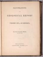
Author
Owen, David Dale
Full Title
(Covers to) Report of a Geological Survey of Wisconsin, Iowa and Minnesota; and incidentally of a Portion of Nebraska Territory ... by David Dale Owen, United States Geologist. Philadelphia: Lippincott, Grambo & Co. 1852. (with) Illustrations to the Geological Report of Wisconsin, Iowa, and Minnesota ... 1852. (on verso of title page) Philadelphia: C. Sherman, Printer, 19 St. James Street.
List No
0690.001
Note
Report of Geological survey and Illustrations and maps in separate volume. Illustrations volume includes twenty-one maps and geologic cross sections as well as numerous drawings. Large full color map bound into the back titled, "Geological Map of Wisconsin, Iowa and Minnesota ... Constructed from observations by the United States Geological Corps ... 1851." Report bound with green cloth covered boards with title embossed on spine. Illustrations bound with purple cloth covered boards with "Illustrations - Owen's Geological Survey" on cover in gold.
Author
Owen, David Dale
Full Title
(Title Page to) Report of a Geological Survey of Wisconsin, Iowa and Minnesota; and incidentally of a Portion of Nebraska Territory ... by David Dale Owen, United States Geologist. Philadelphia: Lippincott, Grambo & Co. 1852. (with) Illustrations to the Geological Report of Wisconsin, Iowa, and Minnesota ... 1852. (on verso of title page) Philadelphia: C. Sherman, Printer, 19 St. James Street.
List No
0690.002
Note
Report of Geological survey and Illustrations and maps in separate volume. Illustrations volume includes twenty-one maps and geologic cross sections as well as numerous drawings. Large full color map bound into the back titled, "Geological Map of Wisconsin, Iowa and Minnesota ... Constructed from observations by the United States Geological Corps ... 1851." Report bound with green cloth covered boards with title embossed on spine. Illustrations bound with purple cloth covered boards with "Illustrations - Owen's Geological Survey" on cover in gold. View of Falls of Pigeon River on opposite title page.
Author
Owen, David Dale
Full Title
(Covers to) Illustrations to the Geological Report of Wisconsin, Iowa, and Minnesota. By David Dale Owen, United States Geologist. Philadelphia: Lippincott, grambo & Co.1852. (with) Report of a Geological Survey of Wisconsin, Iowa and Minnesota; and incidentally of a Portion of Nebraska Territory ... by David Dale Owen ... 1852. (on verso of title page) Philadelphia: C. Sherman, Printer, 19 St. James Street.
List No
0690.003
Note
Illustrations and maps and Report of Geological survey in separate volume. Illustrations volume includes twenty-one maps and geologic cross sections as well as numerous drawings. Large full color map bound into the back titled, "Geological Map of Wisconsin, Iowa and Minnesota ... Constructed from observations by the United States Geological Corps ... 1851." Report bound with green cloth covered boards with title embossed on spine. Illustrations bound with purple cloth covered boards with "Illustrations - Owen's Geological Survey" on cover in gold.
Author
Owen, David Dale
Full Title
(Title Page to) Illustrations to the Geological Report of Wisconsin, Iowa, and Minnesota. By David Dale Owen, United States Geologist. Philadelphia: Lippincott, grambo & Co.1852. (with) Report of a Geological Survey of Wisconsin, Iowa and Minnesota; and incidentally of a Portion of Nebraska Territory ... by David Dale Owen ... 1852. (on verso of title page) Philadelphia: C. Sherman, Printer, 19 St. James Street.
List No
0690.004
Note
Illustrations and maps and Report of Geological survey in separate volume. Illustrations volume includes twenty-one maps and geologic cross sections as well as numerous drawings. Large full color map bound into the back titled, "Geological Map of Wisconsin, Iowa and Minnesota ... Constructed from observations by the United States Geological Corps ... 1851." Report bound with green cloth covered boards with title embossed on spine. Illustrations bound with purple cloth covered boards with "Illustrations - Owen's Geological Survey" on cover in gold.
Author
Owen, David Dale
Full Title
Table I. Trilobites of the lowest sandstones of Wisconsin and Minnesota. (on opposite page view of) Medal-ruled, on steel, from the original Specimens. J.M. Butler. (to accompany) Illustrations to the Geological Report of Wisconsin, Iowa, and Minnesota. (with) Report of a Geological Survey of Wisconsin, Iowa and Minnesota ... 1852.
List No
0690.005
Note
Descriptive list of the specimens and 14 uncolored views from original specimens.
Author
Owen, David Dale
Full Title
Table I A. Trilobites and Fucoidal impressions, from the lowest Protozoic sandstones, F.I., of Wisconsin and Minnesota. (on opposite page view of) Medal-ruled, on steel, from the original Specimens. J.M. Butler. (to accompany) Illustrations to the Geological Report of Wisconsin, Iowa, and Minnesota. (with) Report of a Geological Survey of Wisconsin, Iowa and Minnesota ... 1852.
List No
0690.006
Note
Descriptive list of the specimens and 14 uncolored views from original specimens.
Author
Owen, David Dale
Full Title
Table I B. Specimens containing Lingula, Obolus, and Orbicula, from near the base of the lowest Protozoic sandstones of Wisconsin and Minnesota. (on opposite page view of) Medal-ruled, on steel, from the original Specimens. J.M. Butler. (to accompany) Illustrations to the Geological Report of Wisconsin, Iowa, and Minnesota. (with) Report of a Geological Survey of Wisconsin, Iowa and Minnesota ... 1852.
List No
0690.007
Note
Descriptive list of the specimens and 13 uncolored views from original specimens.
Author
Owen, David Dale
Full Title
Table I C. Fossil, plants, (?) from the Red Sandstones on the Noethwest shore of Lake Superior. From drawings, by J. Chappellsmith. (on opposite page view by) J. Cappell Smith, del. J.M. Butler. (to accompany) Illustrations to the Geological Report of Wisconsin, Iowa, and Minnesota. (with) Report of a Geological Survey of Wisconsin, Iowa and Minnesota ... 1852.
List No
0690.008
Note
Descriptive list of the specimens and 8 uncolored views.
Author
Owen, David Dale
Full Title
Table I D. Mud Furrows, (?) and impressions of plants (?), in the red sandstones of the northwest shore of Lake Superior. Medal ruled on steel from original specimens. (on opposite page view) by R. Whitechurch & B. P. Newman at J. M. Butler's Establishment. (to accompany) Illustrations to the Geological Report of Wisconsin, Iowa, and Minnesota. (with) Report of a Geological Survey of Wisconsin, Iowa and Minnesota ... 1852.
List No
0690.009
Note
Descriptive list of the specimens and 3 uncolored views.
Author
Owen, David Dale
Full Title
Table II. Trilobites, from F. III., A; Gasteropoda and Brachipoda, from F. II., and F. III., A; Together with Fucoidal impressions, (?) from the red sandstones of Lake Superior. (on opposite page view) D.D. Owen, del. J. M. Butler. (to accompany) Illustrations to the Geological Report of Wisconsin, Iowa, and Minnesota. (with) Report of a Geological Survey of Wisconsin, Iowa and Minnesota ... 1852.
List No
0690.010
Note
Descriptive list of the specimens and 13 uncolored views.
Author
Owen, David Dale
Full Title
Table II A. Trilobites and Brachipoda, from the Protozoic rocks of the northwest. Medal ruled on steel from original specimens. (on opposite page view) J. M. Butler. (to accompany) Illustrations to the Geological Report of Wisconsin, Iowa, and Minnesota. (with) Report of a Geological Survey of Wisconsin, Iowa and Minnesota ... 1852.
List No
0690.011
Note
Descriptive list of the specimens and 12 uncolored views.
Author
Owen, David Dale
Full Title
Table II B. Fossils of the shell-beds (F. III., A) and overlying lead-bearing beds (F. III., B) of the upper Magnesian limestone of Wisconsin, Iowa, and Minnesota. Medal ruled on steel from original specimens. (on opposite page view) J. M. Butler. (to accompany) Illustrations to the Geological Report of Wisconsin, Iowa, and Minnesota. (with) Report of a Geological Survey of Wisconsin, Iowa and Minnesota ... 1852.
List No
0690.012
Note
Descriptive list of the specimens and 23 uncolored views.
Author
Owen, David Dale
Full Title
Table III. Spirifers, Orthis and Strophodonta, from the shell-beds of the Iowa and Cedar Rivers, belonging to the Devonian Period. (on opposite page view) D.D. Owen. W.H. Dougal. (to accompany) Illustrations to the Geological Report of Wisconsin, Iowa, and Minnesota. (with) Report of a Geological Survey of Wisconsin, Iowa and Minnesota ... 1852.
List No
0690.013
Note
Descriptive list of the specimens and 19 uncolored views.
Author
Owen, David Dale
Full Title
Table III A. Fossil shells and corals from the carboniferous limestone, and from the adjacent limestones of Iowa of the age of Hamilton Group of New York. (on opposite page view) Medal ruled on steel from original specimens. J.M. Butler. (to accompany) Illustrations to the Geological Report of Wisconsin, Iowa, and Minnesota. (with) Report of a Geological Survey of Wisconsin, Iowa and Minnesota ... 1852.
List No
0690.014
Note
Descriptive list of the specimens and 21 uncolored views.
Author
Owen, David Dale
Full Title
Table IV. Fossil corals, from the carboniferous rocks of Iowa. (on opposite page view) D.D. Owen, del. J.M. Butler. (to accompany) Illustrations to the Geological Report of Wisconsin, Iowa, and Minnesota. (with) Report of a Geological Survey of Wisconsin, Iowa and Minnesota ... 1852.
List No
0690.015
Note
Descriptive list of the specimens and 8 uncolored views.
Author
Owen, David Dale
Full Title
Table V. Fossil shells from the carboniferous rocks of Iowa and Nebraska. (on opposite page view) D.D. Owen, del. J.M. Butler. (to accompany) Illustrations to the Geological Report of Wisconsin, Iowa, and Minnesota. (with) Report of a Geological Survey of Wisconsin, Iowa and Minnesota ... 1852.
List No
0690.016
Note
Descriptive list of the specimens and 17 uncolored views.
Author
Owen, David Dale
Full Title
Table V A. New species of Crinoidea of the carboniferous limestone. (on opposite page view) D.D. Owen, & J. Chappel Smith, del. J.M. Butler. (to accompany) Illustrations to the Geological Report of Wisconsin, Iowa, and Minnesota. (with) Report of a Geological Survey of Wisconsin, Iowa and Minnesota ... 1852.
List No
0690.017
Note
Descriptive list of the specimens and 16 uncolored figures in 35 views.
Author
Owen, David Dale
Full Title
Table V B. New species of Crinoidea of the carboniferous limestone. (on opposite page view) D.D. Owen, del. J.M. Butler. (to accompany) Illustrations to the Geological Report of Wisconsin, Iowa, and Minnesota. (with) Report of a Geological Survey of Wisconsin, Iowa and Minnesota ... 1852.
List No
0690.018
Note
Descriptive list of the specimens and 7 uncolored figures in 13 views.
Author
Owen, David Dale
Full Title
Table VI. Lepidodendrons and fossil ferns, characteristic of the carboniferous sandstones, muscatine quarries, Iowa. (on opposite page view) D.D. Owen, del. J.M. Butler. (to accompany) Illustrations to the Geological Report of Wisconsin, Iowa, and Minnesota. (with) Report of a Geological Survey of Wisconsin, Iowa and Minnesota ... 1852.
List No
0690.019
Note
Descriptive list of the specimens and 8 uncolored views.
Author
Owen, David Dale
Full Title
Table VII. Fossil shells characteristic of the cretaceous formation of Nebraska. (on opposite page view) D.D. Owen. Figuers 2,3,4, and 5, Medal-ruled by R. Whitechurch at J.M. Butler's Establishment. (to accompany) Illustrations to the Geological Report of Wisconsin, Iowa, and Minnesota. (with) Report of a Geological Survey of Wisconsin, Iowa and Minnesota ... 1852.
List No
0690.020
Note
Descriptive list of the specimens and 11 figures in 12 uncolored views.
Author
Owen, David Dale
Full Title
Table VIII. Ammonites and Scaphites, from the cretaceous formation of Nebraska. (on opposite page view) D.D. Owen. Figuers 1,2,3,4, 5 & 7, Medal-ruled by R. Whitechurch at J.M. Butler's Establishment. (to accompany) Illustrations to the Geological Report of Wisconsin, Iowa, and Minnesota. (with) Report of a Geological Survey of Wisconsin, Iowa and Minnesota ... 1852.
List No
0690.021
Note
Descriptive list of the specimens and 7 figures in 11 uncolored views.
Author
Owen, David Dale
Full Title
Table VIII A. Inoceramus and Ammonite, from the cretaceous formation of Nebraska. (on opposite page view) Medal-ruled on steel from original speciment, by R. Whitechurch at J.M. Butler's Establishment. (to accompany) Illustrations to the Geological Report of Wisconsin, Iowa, and Minnesota. (with) Report of a Geological Survey of Wisconsin, Iowa and Minnesota ... 1852.
List No
0690.022
Note
Descriptive list of the specimens and 2 uncolored views.
Author
Owen, David Dale
Full Title
Table IX. Remains of the Rhinoceros and the gigantic Paleotherium of the Ecocene Tertiary of the Mauvaises Terres of Nebraska. (on opposite page view) D.D. Owen. W.H. Dougal. (to accompany) Illustrations to the Geological Report of Wisconsin, Iowa, and Minnesota. (with) Report of a Geological Survey of Wisconsin, Iowa and Minnesota ... 1852.
List No
0690.023
Note
Descriptive list of the specimens and 3 figures in 4 uncolored views.
Author
Owen, David Dale
Full Title
Table X. Remains of Archeotherium and Oreodon of the Eocene tertiary of Nebraska. (on opposite page view) Engraved on steel from daguerreotypes of the original specimens by A.B. Walter, Phila(delphia). (to accompany) Illustrations to the Geological Report of Wisconsin, Iowa, and Minnesota. (with) Report of a Geological Survey of Wisconsin, Iowa and Minnesota ... 1852.
List No
0690.024
Note
Descriptive list of the specimens and 6 uncolored views.
Author
Owen, David Dale
Full Title
Table XI. Additional remains of Archeotherium and Oreodon. All figures of the natural size. (on opposite page view) D.D. Owen, del. A.B. Walter Sc. (to accompany) Illustrations to the Geological Report of Wisconsin, Iowa, and Minnesota. (with) Report of a Geological Survey of Wisconsin, Iowa and Minnesota ... 1852.
List No
0690.025
Note
Descriptive list of the specimens and 3 uncolored views.
Author
Owen, David Dale
Full Title
Table XII. Remains of a species of land turtle, from the Eocene tertiary of Nebraska. (on opposite page view) D.D. Owen. Engraved on steel from daguerreotype of original specimens by J. McGoffin, at J.M. Butler's Establishment. (to accompany) Illustrations to the Geological Report of Wisconsin, Iowa, and Minnesota. (with) Report of a Geological Survey of Wisconsin, Iowa and Minnesota ... 1852.
List No
0690.026
Note
Descriptive list of the specimens and 2 uncolored views.
Author
Owen, David Dale
Full Title
Table XII A. Two species of land turtles, Machairodus, or Sabre-toothed Tiger, and a small species of Rhinoceros from the Eocene Tertiary of Nebraska. (on opposite page view) Engraved on steel from daguerreotype of original specimens. J.M. Butler. (to accompany) Illustrations to the Geological Report of Wisconsin, Iowa, and Minnesota. (with) Report of a Geological Survey of Wisconsin, Iowa and Minnesota ... 1852.
List No
0690.027
Note
Descriptive list of the specimens and 6 uncolored views.
Author
Owen, David Dale
Full Title
Table XII B. Remains of a land turtle, Rhinoceros, and Paleotherium, from the Eocene Tertiary of Nebraska. (on opposite page view) Fig. 1 & 2 engraved on steel from daguerreotype of original specimens. J.M. Butler. (to accompany) Illustrations to the Geological Report of Wisconsin, Iowa, and Minnesota. (with) Report of a Geological Survey of Wisconsin, Iowa and Minnesota ... 1852.
List No
0690.028
Note
Descriptive list of the specimens and 8 uncolored views.
Author
Owen, David Dale
Full Title
Table XIII. Remains of Archaeotherium and Oreodon, from the Eocene Tertiary of Nebraska. Figures are all of the natural size. (on opposite page view) J.M. Butler. (to accompany) Illustrations to the Geological Report of Wisconsin, Iowa, and Minnesota. (with) Report of a Geological Survey of Wisconsin, Iowa and Minnesota ... 1852.
List No
0690.029
Note
Descriptive list of the specimens and 6 uncolored views.
Author
Owen, David Dale
Full Title
Table XIV. Remains of the Rhinoceros, from the Eocene Tertiary of Nebraska. All the figures are reduced one-third. (on opposite page view) J.M. Butler. (to accompany) Illustrations to the Geological Report of Wisconsin, Iowa, and Minnesota. (with) Report of a Geological Survey of Wisconsin, Iowa and Minnesota ... 1852.
List No
0690.030
Note
Descriptive list of the specimens and 3 uncolored views.
Author
Owen, David Dale
Full Title
Table XV. Remains of Eucrotaphus and of the Rhinoceros, from the Eocene Tertiary of Nebraska. All the figures are of natural size. (on opposite page view) Engraved from the original specimens by J.M. Butler. (to accompany) Illustrations to the Geological Report of Wisconsin, Iowa, and Minnesota. (with) Report of a Geological Survey of Wisconsin, Iowa and Minnesota ... 1852.
List No
0690.031
Note
Descriptive list of the specimens and 4 uncolored views.
Author
Owen, David Dale
Full Title
Map showing the positions of the Bad Lands or Mauvaises Terres of Nebraska, from a draft by John Evens of the U.S. Geological Survey. (to accompany) Illustrations to the Geological Report of Wisconsin, Iowa, and Minnesota. (with) Report of a Geological Survey of Wisconsin, Iowa and Minnesota ... 1852.
List No
0690.032
Note
Uncolored map. Shows rivers, forts, mountains. Relief shown by hachures.
Author
Owen, David Dale
Full Title
Geological map of parts of Minnesota and Wisconsin. Designed to show portions of the Rock formations now concealed by drift. By J.G. Norwood. Drawn by J. Chappell smith. (to accompany) Illustrations to the Geological Report of Wisconsin, Iowa, and Minnesota. (with) Report of a Geological Survey of Wisconsin, Iowa and Minnesota ... 1852.
List No
0690.033
Note
Hand color map. References indicated on the maps are Limestones of Cedar Valley, Upper and Lower Magnesium Limestone, Lowest Sandstones, Metamorphic Schists, and Granite & Sienitic Rocks. Prime meridian is Washington.
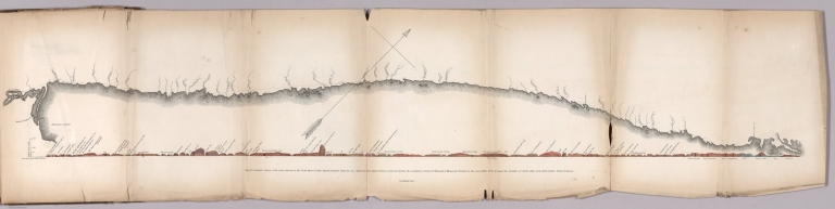
Author
Owen, David Dale
Full Title
General connected section of the rocks exposed on the North shore of Lake Superior between Fond du Lac Superieur and Pigeon Point, as observed during the geological surveys of Wisconsin & Minnesota territory, in the year 1848, 49 & 50, under the direction of David Dale Owen, M.D. United States Geologist. By Richard Owen. (to accompany) Illustrations to the Geological Report of Wisconsin, Iowa, and Minnesota. (with) Report of a Geological Survey of Wisconsin, Iowa and Minnesota ... 1852.
List No
0690.034
Note
Hand color geologic cross section on sheet 31x135 cm. folded to 31x20. with explanation of rock formations.
Author
Owen, David Dale
Full Title
Geological map: Coast view and section of Pigeon Point. By Richard Owen. Engd. on steel by W.H. Dougal, Washington, D.C. Cost section from the West end of Grand Portage Bay to the extremity of Pigeon Point in direction North of East. By Richard Owen. (on upper right margin) Pl.N. (to accompany) Illustrations to the Geological Report of Wisconsin, Iowa, and Minnesota. (with) Report of a Geological Survey of Wisconsin, Iowa and Minnesota ... 1852.
List No
0690.035
Note
Hand color geologic map and cross section, folded to 31x21 cm., with uncolored view of the coast folded to 31x20 cm. On upper right margin Pl.N.
|