|
Author
Sanson, Nicolas, 1600-1667
Full Title
Le Canada, ou Nouvelle France &c. : tiree de diverses relations des Francois, Anglois, Hollandois, &c. Par N. Sanson d'Abbeville, Geographe ordre du Roy ... 1657. (to accompany) L'Amerique en plusieurs cartes, & en divers traitte's de geographie et d'histoire ... A Paris chez l'Autheur.
List No
11576.012
Note
Copper engraved double page map of Canada and the Great Lakes. Showing political and administrative boundaries, major cities, towns, villages, rivers, mountains, drainage, etc. Relief shown pictorially.
Author
Blaeu, Joan, 1596-1673
Full Title
Extrema Americae Versus Boream
List No
15664.016
Author
Blaeu, Joan, 1596-1673
Full Title
Nova Et Accvratissima Totius Terrarvm Orbis Tabvla
List No
10017.016
Note
World map
Author
Blaeu, Joan, 1596-1673
Full Title
Nova Zemla
List No
10017.021
Note
40 Milliaria Germanica communia = 8.2 cm
Author
Blaeu, Joan, 1596-1673
Full Title
Nova & Accvrata Wolgae Flvminis
List No
10017.096
Note
18 Milliaria Germanica communia = 10.7 cm [et al.]
Author
Blaeu, Joan, 1596-1673
Full Title
Palatinatvs Posnaniensis��� Nova Delineatio
List No
10017.099
Note
4 Milliaria Magna = 6.5 cm [et al.]
Author
Blaeu, Joan, 1596-1673
Full Title
Tractvvm Borvssiae... nova et elaboratissima delineatio
List No
10017.102
Note
Scala 1800 Rutten oder Milliare comm. Prussicum = 5.4 cm
Author
Blaeu, Joan, 1596-1673
Full Title
Marchionatus Brandenburgici Partes Duae, Nova Marchia et Uckerana
List No
10017.159
Note
4 Milliaria Germanica = 7.0 cm
Author
Blaeu, Joan, 1596-1673
Full Title
Nova & Accurata Dvcatvvm Slesvici Et Holsatiae Tabvla
List No
10017.165
Note
With 16 town plans. 4 Milliare Germanicum = 4.9 cm
Author
Blaeu, Joan, 1596-1673
Full Title
Nova & Accvratissima Dvcatvs Holsatiae Tabvla
List No
10017.166
Note
Die Masse der Teutschen Meilln Milliaria Germanicum = 6.0 cm
Author
Blaeu, Joan, 1596-1673
Full Title
Celeberrimi Flvvii Alvis nova delineatio
List No
10017.175
Note
Unusual perspective view of Hamburg and the Elbe River mouth. 2 Milliaria Germanica communia = 9.2 cm
Author
Blaeu, Joan, 1596-1673
Full Title
Paderbornensis Episcopatus Descriptio Nova
List No
10017.188
Note
3 Miliaria Germanica Communia = 9.9 cm [et al.]
Author
Blaeu, Joan, 1596-1673
Full Title
Sveviae Nova Tabulam
List No
10017.215
Note
8 Milliaria Germanica communia = 6.7 cm [et al.]
Author
Blaeu, Joan, 1596-1673
Full Title
Nova Et Exacta Geographica Salae Et Castellaniae Iprensis
List No
10017.238
Note
Scala Virgarum Flandricarum, 1600 = 4.5 cm [et al.]
Author
Blaeu, Joan, 1596-1673
Full Title
Nova Et Accvrata Comitatvs Et Ditionis Alostanae... Tabvla
List No
10017.246
Note
Een Vlaemsche myle van 1000 Roeden = 5.2 cm
Author
Blaeu, Joan, 1596-1673
Full Title
Agri Zypani nova descript.
List No
10017.270
Note
Schale van 600 Roeden, Sÿpse Lant Roeden = 6.7 cm, Sÿpse Dÿck Roeden = 7.6 cm
Author
Blaeu, Joan, 1596-1673
Full Title
Nova Picardiae Tabula
List No
10017.442
Note
8 Milliaria Gallica Communia = 7.5 cm [et al.]
Author
Blaeu, Joan, 1596-1673
Full Title
Nova et Accurata delineatio geographica Episcopatus Metensis
List No
10017.486
Note
Scala Milliarium Lotharingicorum Magna, Mediocra, Parva = 7.6, 6.5 and 5.4 cm; 4 Milliaria Germanica communia = 11.3 [et al.]
Author
Blaeu, Joan, 1596-1673
Full Title
Alpinae seu Foederatae Rhaetiae… nova descriptio
List No
10017.498
Note
3 Milliaria Rhætica; quorum singula duarum conficiunur horarum spatio ab expeditio pedite; 12 verò const I gradui = 7.2 cm [et al.]
Author
Blaeu, Joan, 1596-1673
Full Title
Regnorvm Hispaniae nova descriptio
List No
10017.565
Note
17.5 Milliaria Hispanica = 4.0 cm [et al.]
Author
Blaeu, Joan, 1596-1673
Full Title
Vtrivsque Castiliae nova descriptio
List No
10017.566
Note
14 Milliaria Hispanica communia = 5.3 cm
Author
Blaeu, Joan, 1596-1673
Full Title
Africae nova descriptio
List No
10017.594
Author
Blaeu, Joan, 1596-1673
Full Title
Nova aegypti Tabvla
List No
10017.597
Note
25 Milliaria Germanica = 6.3 cm
Author
Blaeu, Joan, 1596-1673
Full Title
Imperii Sinarvm Nova Descriptio
List No
10017.622
Author
Blaeu, Joan, 1596-1673
Full Title
Americae nova Tabula
List No
10017.641
Author
Blaeu, Joan, 1596-1673
Full Title
Extrema Americae Versus Boream
List No
10017.642
Author
Blaeu, Joan, 1596-1673
Full Title
Nova Belgica Et Anglia Nova
List No
10017.643
Note
20 Milliaria Germanica communia = 4.6 cm
Author
Blaeu, Joan, 1596-1673
Full Title
Nova Virginiae Tabvla
List No
10017.644
Note
12 Milliaria Germanica communia 15 pro Uno gradu = 7.9 cm
Author
Blaeu, Joan, 1596-1673
Full Title
Nova Hispania Et Nova Galicia
List No
10017.646
Note
15 Milliaria Hispanica = 4.7 cm
Author
[Morden, Robert, approximately 1650-1703, Cockerill, Thomas, active 1674-1702]
Full Title
(Text Page to) Of America (3) -- Of the North West part of America (1).
List No
14323.175
Note
On left - descriptive text for map, America, on prior page (361). Text spans pages 361-364. On right - map of Greenland. Map includes title cartouche: The North West part of America, by Robt. Morden. Shows political boundaries, cities, topography, drainage, coastline and islands. Relief shown pictorially. Contains latitudinal and longitudinal lines. Map is 11 x 12 cm, on sheet 15 x 20 cm. Accompanied by descriptive text. Includes section: Of Greenland. Text spans pages 363 [365]-368 [370]; 365 misprinted as 363; 370 misprinted as 368, following which, pagination misprinted for the remainder of the volume.
Author
[Nolin, Jean Baptiste, 1648-1708, Coronelli, Vincenzo (1650-1718), Du Tralage, Jean Nicolas, -169]
Full Title
Partie Orientale du Canada ou de la Nouvelle France ou sont les Provinces, ou Pays de Sagvenay, Canada, Acadie etc. les Peuples, ou Nations des Etechemins, Iroquois, Attiquameches etc. Avec la Nouvelle Angleterre, la Nouvelle Ecosse, la Nouvelle Yorck, et la Virginie, les Isles de Terre Neuve, de Cap Breton etc. le Grand Banc etc. Dressee sur les Memoires les plus Nouveaux. Par le P. Coronelli Cosmographe de la Serenisme. Rep. de Venise. Corrigée et augmentée par le Sr. Tillemon; et dediée a Monsieur l'Abbé Baudrand. Par son tres humble Serviteur J. B. Nolin. A Paris, Chez J. B. Nolin, sur le Quay de l’Horloge du Palais, proche le Pont Neuf, a l'enseigne de la Place des Victoires. Avec Privilege du Roy. 1689.
List No
14353.048
Note
Map of eastern Canada. Title translates to: Eastern part of Canada or New France, with the Provinces, of Saguenay, Canada, Acadia etc., and the peoples, or nations of Etechemins, Iroquois, Attiquameches etc, and with New England, Nova Scotia, New York, and Virginia, the Isles of Newfoundland, Cape Breton etc. Shows political boundaries, cities, forts, topography, lakes, drainage, coastlines, shoals, islands and sea monsters. Features the territories of indigenous peoples therein. Relief shown pictorially. Includes latitudinal and longitudinal lines, as well as a legend, four bar scales and explanatory notes. Decorative cartouche with indigenous figures, flora and fauna. Black and white engraving with hand-colored borders. Map is 43 x 58 cm, on double sheet 50 x 67 cm. (Plate number handwritten in ink on verso.)
Author
Popple, Henry
Full Title
A Map of the British Empire in America with the French and Spanish Settlements adjacent thereto. by Henry Popple. (Sheet 7).
List No
2874.009
Note
Uncolored map covering the area ranging from Massachusetts to the Grand Fishing Bank. Fishing Bank includes soundings.
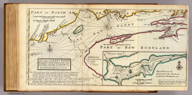
Author
[Blackmore, Nathaniel, Moll, Herman, d. 1732]
Full Title
A description of the Bay of Fundy shewing ye coast, islands, harbours, creeks, coves, rocks & sholes, soundings & anchorings &c. Observed by Nat. Blackmore in ye year 1711 and 1712. by Her Majesties Special Command. (Drawn by H. Moll, Geographer). (with) The harbour of Annapolis royal by Nathaniel Blackmore Esqr. Printed and sold by Tho: Bowles next ye Chapter House in St. Pauls Church Yard, & Ino: Bowles at ye Black Horse in Cornhill, (1736?)
List No
5580.048
Note
Hand col. engraved map with inset. Depths shown by soundings. Includes geographical note.
Author
Anonymous
Full Title
Plan of Cape Breton.
List No
10666.000
Author
Popple, Henry
Full Title
A Map of the British Empire in America with the French and Spanish Settlements adjacent thereto. by Henry Popple. (Sheet 7).
List No
5810.017
Note
Colored map covering the area ranging from Massachusetts to the Grand Fishing Bank. Fishing Bank includes soundings.
Author
Bowen, Emanuel
Full Title
A new & accurate map of the islands of Newfoundland, Cape Briton, St. John and Anticosta; together with the neighbouring countries of Nova Scotia, Canada &c. Drawn from the most approved modern maps and charts, and regulated by astronl. observatns. By Eman. Bowen. (London: Printed for William Innys, Richard Ware, Aaron Ward, J. and P. Knapton, John Clarke, T. Longman and T. Shewell, Thomas Osborne, Henry Whitridge ... M.DCC.XLVII)
List No
3733.062
Note
Engraved map. Shows banks, etc. Has ornamental cartouche. Relief shown pictorially.
Author
Bellin, Jacques Nicolas, 1703-1772
Full Title
Carte réduite du Golphe de St. Laurent contenant l'Isle de Terre-Neuve et partie de la Coste des Esquimaux, l'Isle Royale, l'Isle St. Jean et celle d'Anticosti & ca.
List No
10712.000
Author
[Bowen, Emanuel, Gibson, John]
Full Title
Nova Scotia. (to accompany) Atlas Minimus or a New Set of Pocket Maps of the Several Empires, Kingdoms and States of the Known World, with Historical Extracts relative to each. Drawn and Engraved by J. Gibson from the Best Authorities, Revis'd, Corrected and Improv'd by Eman: Bowen Geographer to His Majesty.
List No
0300.043
Note
First edition. The "Historical Extracts" are short bits of text printed on the maps giving relevant geographical information. A revised edition was published in London in 1792. In 1759, another edition was published adding separate geographical descriptions and correcting some of the maps (see our copy). The Philadelphia 1798 edition by Mathew Carey incorporates the 1759 edition text word for word (excepting the maps of United States which Carey omits in favor of his pocket atlas of the U.S.). Gibson and Bowen made the four sheet map of North America (Stevens 49), and Gibson made the four sheet map of America (Stevens 3).
Author
[Bowen, Emanuel, Gibson, John]
Full Title
Island Of Cape Breton. (to accompany) Atlas Minimus or a New Set of Pocket Maps of the Several Empires, Kingdoms and States of the Known World, with Historical Extracts relative to each. Drawn and Engraved by J. Gibson from the Best Authorities, Revis'd, Corrected and Improv'd by Eman: Bowen Geographer to His Majesty.
List No
0300.050
Note
First edition. The "Historical Extracts" are short bits of text printed on the maps giving relevant geographical information. A revised edition was published in London in 1792. In 1759, another edition was published adding separate geographical descriptions and correcting some of the maps (see our copy). The Philadelphia 1798 edition by Mathew Carey incorporates the 1759 edition text word for word (excepting the maps of United States which Carey omits in favor of his pocket atlas of the U.S.). Gibson and Bowen made the four sheet map of North America (Stevens 49), and Gibson made the four sheet map of America (Stevens 3).
Author
Jefferys, Thomas
Full Title
(Covers to) The natural and civil history of the French dominions in North and South America. Giving a particular account of the climate, soil, minerals, animals, vegetables, manufactures, trade, commerce, and languages ... Illustrated by maps and plans of the principal places, collected from the best authorities, and engraved by T. Jefferys, Geographer to his Royal Highness the Prince of Wales. Part I. Containing a description of Canada and Louisiana. London, Printed for Thomas Jefferys at Charing-Cross. MDCCLX.
List No
4796A
Author
Jefferys, Thomas
Full Title
(Title Page to) The natural and civil history of the French dominions in North and South America. Giving a particular account of the climate, soil, minerals, animals, vegetables, manufactures, trade, commerce, and languages ... Illustrated by maps and plans of the principal places, collected from the best authorities, and engraved by T. Jefferys, Geographer to his Royal Highness the Prince of Wales. Part I. Containing a description of Canada and Louisiana. London, Printed for Thomas Jefferys at Charing-Cross. MDCCLX.
List No
4796B
Note
Printed in red and black.
Author
[Jefferys, Thomas, Holland, Samuel, 1728-1801]
Full Title
A new map of Nova Scotia and Cape Britain, with the adjacent parts of New England and Canada, composed from a great number of actual surveys, and other materials regulated by many new astronomical observations of the longitude as well as latitude; with an explanation. 1755 published according to Act of Parliament by Thos. Jefferys, Geographer to His Royal Highness the Prince of Wales at the corner of St. Martins Lane, Charing Cross, London. (1760)
List No
4796.004
Note
Engraved map. Borders hand col. Relief shown pictorially. Shows Indian tribes, fishing banks, roads with distances, etc. Prime meridian: Ferro.
Author
[Gridley, Richard, Jefferys, Thomas]
Full Title
A plan of the city and fortifications of Louisburg; from a survey made by Richard Gridley, Lieut. Coll. of the Train of Artillery in 1745. ... A plan of the city and harbour of Louisburg with the French batteries that defended it and those of the English, shewing that part of Gabarus Bay in which they landed, and the ground on which they encamped during the siege in 1758. (with) A map of Gabarus Bay, adjoining Louisburg. Published by Thos. Jefferys, Geographer to the Prince of Wales at Charing Cross, Octobr. 9, 1758. Price 2s.
List No
4796.005
Note
Two engraved maps on 1 sheet, with inset. Relief shown by hachures; depths by soundings. City plan shows buildings, etc. Includes profile. "Harbour" map at (ca. 1:21,000) scale; Gabarus Bay map at (ca. 1:150,000) scale.
Author
Bellin, Jacques Nicolas, 1703-1772
Full Title
Carte De L'Acadie et Pays Voisins.
List No
6903.034
Note
Decorative title cartouche. Shows settlements. Relief shown pictorially.
Author
Bellin, Jacques Nicolas, 1703-1772
Full Title
Plan Du Port Royal dans l'Acadie : Appellé Aujour d'. par les Anglois Annapolis Royal.
List No
6903.035
Note
Decorative title cartouche. Relief shown by hachures. Depths shown by soundings.
Author
Bellin, Jacques Nicolas, 1703-1772
Full Title
Plan De La Baye De Chibouctou : nommée par les Anglois Halifax. (inset) Plan de la Ville d'Halifax.
List No
6903.036
Note
Decorative title cartouche. Relief shown by hachures. Depths shown by soundings.
Author
Montresor, John, 1736-1799
Full Title
Map of Nova Scotia or Acadia with the Islands of Cape Breton and St. John's. from actual surveys, by Captn. Montresor, engir., 1768. London; Printed & sold by A. Dury, 1768.
List No
13078.000
Note
Engraved hand colored map, published on 8 sheets, depicts Nova Scotia, Cape Breton and St. John's, now prince Edward Island and part of New Brunswick. Shows place names, forts, and administrative boundaries on St. John's Island. Relief shown pictorially and by hachures. Depths shown by soundings. Prime meridian is Ferro. Includes pictorial inscription to John Manners in upper left corner. Incorporates the recent surveys of St. John's Island (now Prince Edward Island) by Samuel Holland.
Author
[Postlethwayt, Malachy, 1707 – 1767, Boulton, S.]
Full Title
North America, performed under the patronage of Louis Duke of Orleans, First Prince of the Blood; by the Sieur Danville. Greatly improved by Mr. Bolton. Engraved by R. W. Seale. (to accompany) The Universal Dictionary Of Trade and Commerce ... By Malachy Postlethwayt. The fourth edition. Vol. I. London : Printed by W. Starhan, I. and F. Rivington. MDCCLXXIV (1774).
List No
13171.012
Note
1 map on 4 sheets. "For Mr. Postlethwayte's Dict. of commerce." Includes inset: Chart of Baffin Bay and Hudson Bay and historical and descriptive notes. Relief shown pictorially. Title from sheet II, with decorative cartouche. Shows provinces, cities and towns, forts, Indian villages and tribal territory. Also shows shoals, banks, and other navigational hazards off the coast of Nova Scotia and in the Caribbean area.
Author
[Postlethwayt, Malachy, 1707 – 1767, Boulton, S.]
Full Title
North America, performed under the patronage of Louis Duke of Orleans, First Prince of the Blood; by the Sieur Danville. Greatly improved by Mr. Bolton. Engraved by R. W. Seale. (to accompany) The Universal Dictionary Of Trade and Commerce ... By Malachy Postlethwayt. The fourth edition. Vol. I. London : Printed by W. Starhan, I. and F. Rivington. MDCCLXXIV (1774).
List No
13171.013
Note
1 map on 4 sheets. "For Mr. Postlethwayte's Dict. of commerce." Includes inset: Chart of Baffin Bay and Hudson Bay and historical and descriptive notes. Relief shown pictorially. Title from sheet II, with decorative cartouche. Shows provinces, cities and towns, forts, Indian villages and tribal territory. Also shows shoals, banks, and other navigational hazards off the coast of Nova Scotia and in the Caribbean area.
Author
[Postlethwayt, Malachy, 1707 – 1767, Boulton, S.]
Full Title
North America, performed under the patronage of Louis Duke of Orleans, First Prince of the Blood; by the Sieur Danville. Greatly improved by Mr. Bolton. Engraved by R. W. Seale. (to accompany) The Universal Dictionary Of Trade and Commerce ... By Malachy Postlethwayt. The fourth edition. Vol. I. London : Printed by W. Starhan, I. and F. Rivington. MDCCLXXIV (1774).
List No
13171.014
Note
1 map on 4 sheets. "For Mr. Postlethwayte's Dict. of commerce." Includes inset: Chart of Baffin Bay and Hudson Bay and historical and descriptive notes. Relief shown pictorially. Title from sheet II, with decorative cartouche. Shows provinces, cities and towns, forts, Indian villages and tribal territory. Also shows shoals, banks, and other navigational hazards off the coast of Nova Scotia and in the Caribbean area.
|