|
Author
Herrera y Tordesillas, Antonio de, -1625
Full Title
Descripcion de las del Poniente.
List No
14476.019
Note
Map of areas including the East Indies, Papua New Guinea and the Solomon Islands. Shows countries, cities, bodies of water, drainage, coastlines and islands. Includes latitudinal and longitudinal lines. Indexed to indicate city names. Black and white engraving. Map is 21 x 29 cm, on double sheet 29 x 36 cm. Appears in Descriptio Indiae Occidentalis per Antonium de Herrera regium Indiarum et Castellae historiographum, the first part of Nieuwe werelt anders ghenaempt West-Indien.
Author
Le Maire, Jacques, 1585-1616
Full Title
Nova Guinea.
List No
14476.030
Note
Map of Papua New Guinea. Shows cities, bodies of water, drainage, coastlines and islands. Features voyages routes. Includes rhumb lines, latitudinal and longitudinal lines, as well as compass roses with north oriented toward top of sheet. With descriptive notes in cartouche. Black and white engraving. Map is 20 x 28 cm, on double sheet 29 x 36 cm. Appears in Spieghel der Australische navigatie, the third part of Nieuwe werelt anders ghenaempt West-Indien.
Author
[Herrera y Tordesillas, Antonio de, -1625, Ordóñez de Ceballos, Pedro, approximately 1545-approximately 1630, Le Maire, Jacques, 1585-1616, Aerssens, Cornelis van, 1545-1627]
Full Title
(Text Page to) Vocabulaer : Oft tale van d'eylanden Salomonis. (2)
List No
14476.032
Note
Vocabulary list for foreign languages appearing in Spieghel der Australische navigatie, the third part of Nieuwe werelt anders ghenaempt West-Indien. Includes sections: Tale van het Cocos-Eylant [Cocos Island] -- Tale oft spraecke van de Custe van Guinea nova [Coast of Papua New Guinea]. Spans four pages.
Author
[Herrera y Tordesillas, Antonio de, -1625, Ordóñez de Ceballos, Pedro, approximately 1545-approximately 1630, Le Maire, Jacques, 1585-1616, Aerssens, Cornelis van, 1545-1627]
Full Title
(Text Page to) Vocabulaer : Oft tale van d'eylanden Salomonis. (3)
List No
14476.033
Note
Vocabulary list for foreign languages appearing in Spieghel der Australische navigatie, the third part of Nieuwe werelt anders ghenaempt West-Indien. Includes sections: Tale oft spraecke van de Custe van Guinea nova [Coast of Papua New Guinea] -- Spraecke vant Eylant Moyses [Island Moyses] -- Spraecke van't Eylandt Moo [Island Moo]. Spans four pages.
Author
[Coronelli, Vincenzo (1650-1718), Accademia cosmografica degli Argonauti.]
Full Title
(Text Page to) Isolario del P. Coronelli. (with) Het Niew Hollandt. (to accompany) Isolario descrittione geografico-historica, sacro-profana, antico-moderna ... e in supplimento dei XIV volumi del Bleau. Tomo II dell' Atlante veneto. Opera, e Studio del P. Maestro Vincenzo Coronelli ... A Spese dell Auttore MDCLXXXXVI (1696).
List No
11391.133
Note
Text to Isolario del P. Coronelli. Parte II. With engraved map of Papua New Guinea and Australia.
Author
[Carteret, Philip, d. 1796, Hawkesworth, John, 1715?-1773]
Full Title
Nova Hibernia. Publish'd Novr. 1st, 1772. (London: printed for W. Strahan; and T. Cadell in the Strand, MDCCLXXIII).
List No
3403.015
Note
Engraved nautical chart. Depths shown by soundings. Oriented with north toward upper left. Includes 7 coastal views.
Author
[Carteret, Philip, d. 1796, Hawkesworth, John, 1715?-1773]
Full Title
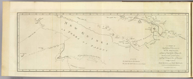
A chart of Captn. Carteret's discoveries at New Britain, with part of Captn. Cooke's passage thro Endeavor Streights, & of Captn. Dampier's tract & discoveries in 1699, & 1700, at New Guinea and New Britain. Engraved by W. Whitchurch, Pleasant Row, Islington. (London: printed for W. Strahan; and T. Cadell in the Strand, MDCCLXXIII).
List No
3403.016
Note
Engraved nautical chart showing coastal features only. Depths shown by soundings.
Author
[Carteret, Philip, d. 1796, Hawkesworth, John, 1715?-1773]
Full Title
Three views of the Admiralty Isles. (with 6 other coastal views of Joseph Freewills Islands, Current Island, St. Andrews Islands, bay at south end of Mindanao). Publish'd Novr. 1st, 1772. (London: printed for W. Strahan; and T. Cadell in the Strand, MDCCLXXIII).
List No
3403.017
Note
Nine engraved coastal views on 1 sheet.
Author
Dalrymple, Alexander
Full Title
Plan of the Islands of Aiou or Yowl by Capt. Thomas Forrest
List No
16141.149
Author
Dalrymple, Alexander
Full Title
Plan of Carterets Harbour in St. Georges Sound New Britain 1767
List No
16141.153
Note
Note that this area is not New Britain but in fact on the western side of New Ireland, facing to the west St. George's Channel with New Britain on the other side.
Author
Dalrymple, Alexander
Full Title
Plan of English Cove and Gower's Harbour in New Britain 1767.
List No
16141.154
Author
Dalrymple, Alexander
Full Title
Plan of Port Praslin...1769
List No
16141.155
Author
Dalrymple, Alexander
Full Title
Plan of Mackrel Bay and Water Bay on the So. Coast of New Guinea (with) Port Montague on New Britain (with) Plan of the Bay Choiseuil
List No
16141.160
Author
Elwe, Jan Barend
Full Title
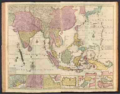
4 Partie de la nouvelle grande carte des Indes Orientales, contenant les Isles de Borneo, Java, Celebes, Mindanao, Gilolo, Molucques, La Nouvelle Guinée, La Nouvelle Bretagne, & les Nouvelles Philippines; avec les Isles de Sumbawa, Serbira, Solor, Bouton & Pangesane dressée avec soin, sur plusieurs cartes manuscriptes, par un habile connoisseur; & publiée a Amsterdam par Jan Bt. Elwe. MDCCXCII.
List No
14478.047
Note
Map of Asia, including Borneo, Java, Celebes [Sulawesi], Gilolo [Halmahera], the Maluku Islands (Indonesia), Mindanao (Philippines) and Papua New Guinea. Shows countries, regions, cities, topography, vegetation, bodies of water, drainage, coastlines and islands. Relief shown pictorially. Includes a compass rose with north oriented toward top of sheet, latitudinal and longitudinal lines, and descriptive notes throughout. Inset maps: Isle de Sumbawa -- Isles de Serbira et de Solor -- Isles de Bouton et Pangesane. Hand-colored engraving. Map is 49 x 59 cm, on double sheet 58 x 70 cm. Fourth of four sheets.
Author
Elwe, Jan Barend
Full Title
(Composite Map to) 1 Partie de la nouvelle grande carte des Indes Orientales, contenant les Terres du Mogol, Surate, Malabar, Cormandel, Bengale, Aracan, Pegu, Siam, Camboje, Tonquin, & une partie de la Chine -- 2 Partie de la nouvelle grande carte des Indes Orientales, contenant les Empires de la Chine & du Japon, les Isles Philippines, Couchin, & les Isles Marianes -- 3 Partie de la nouvelle grande carte des Indes Orientales, contenant les Isles Maldives, Ceyi, An, Malacca, Sumatra &c. avec les terres adjacentes de Couchin, Negombo, Colombo & Sourabaia -- 4 Partie de la nouvelle grande carte des Indes Orientales, contenant les Isles de Borneo, Java, Celebes, Mindanao, Gilolo, Molucques, La Nouvelle Guinée, La Nouvelle Bretagne, & les Nouvelles Philippines; avec les Isles de Sumbawa, Serbira, Solor, Bouton & Pangesane dressée avec soin, sur pluseurs cartes manuscrites, par un habile connoisseur; & publiée a Amsterdam par Jan Bt. Elwe. MDCCXCII.
List No
14478.048
Note
Composite map of Asia, including the Mughal Empire [current-day India, Pakistan and Afghanistan], the Malabar, Coromandel, Bengal and Aracan regions, Siam [current-day Thailand], Camdodia, Tonquin [current-day Vietnam], China, Japan, the Philippines, the Mariana Islands, Maldives, Ceylon [current-day Sri Lanka], Malaysia, Sumatra (Indonesia), Borneo, Java, Celebes [Sulawesi], Gilolo [Halmahera], the Maluku Islands (Indonesia), Mindanao (Philippines) and Papua New Guinea. Shows countries, regions, cities, topography, vegetation, bodies of water, drainage, coastlines and islands. Relief shown pictorially. Includes compass roses with north oriented toward top of sheet, bar scales, latitudinal and longitudinal lines, and descriptive notes throughout. Inset maps: Carte de Royaume de Couchin de Coilan et de Cranganor -- Carte de Nigombo, Colombo -- Carte de Princepaute de Soerabaye et Terre de Grissik -- Isle de Sumbawa -- Isles de Serbira et de Solor -- Isles de Bouton et Pangesane. Hand-colored engraving. Composite map is 98 x 118 cm, on four double sheets, together 116 x 140 cm.
Author
[Reilly, Franz Johann Joseph von (1766-1820), Kininger, Vinzenz Georg]
Full Title
Karte von der Inselwelt Polynesien oder dem funften Welttheile : nach Djurberg und Roberts. Neu verzeichnet herausgegeben von Franz Joh. Jos. von Reilly. Zu finden im von Reilly'schen Landkarten und Kunstwerke Verschleiss Komptoir. Wien, 1795. Gestochen von Kil. Ponheimer. (inset) I. St. Daniel. (to accompany) Grosser Deutscher Atlas.
List No
11151.010
Note
Double page engraved hand color map of Australia and South West Pacific, showing tracks of explorers from 1520 (Magellan). Tasmania shown joined to Australian mainland ; Australia called 'Ulimaroa' ; Papua New Guinea shown as two islands. Shows administrative divisions, cities and towns, roads, rivers and canals, etc. Relief shown pictorially.
Author
[Klinger, Johann Georg, 1764-1806, Müller, Johann Wolfgang]
Full Title
Australie.
List No
14512.045
Note
Map representing Australia, Oceania, and part of current-day Philippines, Papua New Guinea, Indonesia, and Malaysia. Part of the slipcase "V. Australie". Map shows political boundaries, drainage, bodies of water, coastlines, and islands. Includes latitudinal and longitudinal lines. Hand colored engraving. Map is 9 x 10 cm, on card 10 x 11 cm.
Author
Vandermaelen, Philippe, 1795-1869
Full Title
Iles de l'Amiraute. Oceanique no. 24. (Dresse par Ph. Vandermaelen, lithographie par H. Ode. Sixieme partie. - Oceanique. Bruxelles. 1827)
List No
2212.352
Note
Hand col. lithographed map. Relief shown by pictorially. Covers also part of Bismarck Archipelago and northeastern Papua New Guinea. Prime meridian: Paris.
Author
Vandermaelen, Philippe, 1795-1869
Full Title
Partie de l'Archipel de la Nlle. Irlande. Oceanique no. 25. (Dresse par Ph. Vandermaelen, lithographie par H. Ode. Sixieme partie. - Oceanique. Bruxelles. 1827)
List No
2212.353
Note
Hand col. lithographed map. Relief shown by pictorially and by hachures. Covers also the Green Islands and part of Buka. Includes text: Note sur les iles de la Amiraute -- Note sur la Nouvelle-Bretagne et la Nouvelle-Irlande. Prime meridian: Paris.
Author
Vandermaelen, Philippe, 1795-1869
Full Title
Partie de la Nouvelle Guinee. Oceanique no. 31. (Dresse par Ph. Vandermaelen, lithographie par H. Ode. Sixieme partie. - Oceanique. Bruxelles. 1827)
List No
2212.359
Note
Hand col. lithographed map. Relief shown pictorially and by hachures. Covers coasts of eastern Papua New Guinea, the Trobriand and D'Etrecasteaux islands and southern New Britain. Prime meridian: Paris.
Author
Vandermaelen, Philippe, 1795-1869
Full Title
Partie des Iles Salomon. Oceanique no. 32. (Dresse par Ph. Vandermaelen, lithographie par H. Ode. Sixieme partie. - Oceanique. Bruxelles. 1827)
List No
2212.360
Note
Hand col. lithographed map. Relief shown by hachures. Covers also portion of the Louisiade Archipelago. Prime meridian: Paris.
Full Title
New Guinea and the Papuan Archipelago. (with) Astrolabe Bay. (with) Gazelle Peninsula. (Published at the office of "The Times," London, 1895)
List No
1010.076
Note
Color maps with 3 insets. Relief shown by hachures and spot heights. Show settlements, etc. Includes inset of Wales for comparison.
Author
Langhans, Paul
Full Title
Nr. 24. Schutzgebiet des Neu-Guinea Kompanie in 6 Blaettern, Blatt 1. (Reserve of the New Guinea Company in 6 sheets, Sheet 1.)
List No
8772.043
Author
Langhans, Paul
Full Title
Nr. 25. Schutzgebiet des Neu-Guinea Kompanie in 6 Blaettern, Blatt 2. (Reserve of the New Guinea Company in 6 sheets, Sheet 2.)
List No
8772.044
Author
Langhans, Paul
Full Title
Nr. 26. Schutzgebiet des Neu-Guinea Kompanie in 6 Blaettern, Blatt 3. (Reserve of the New Guinea Company in 6 sheets, Sheet 3.)
List No
8772.045
Author
Langhans, Paul
Full Title
Nr. 27. Schutzgebiet des Neu-Guinea Kompanie in 6 Blaettern, Blatt 4. (Reserve of the New Guinea Company in 6 sheets, Sheet 4.)
List No
8772.049
Author
Langhans, Paul
Full Title
Nr. 28. Schutzgebiet des Neu-Guinea Kompanie in 6 Blaettern, Blatt 5. (Reserve of the New Guinea Company in 6 sheets, Sheet 5.)
List No
8772.050
Author
Langhans, Paul
Full Title
Nr. 29. Schutzgebiet des Neu-Guinea Kompanie in 6 Blaettern, Blatt 6. (Reserve of the New Guinea Company in 6 sheets, Sheet 6.)
List No
8772.051
Author
[Andree, Richard, Times (London, England)]
Full Title
New Guinea and the Papuan Archipelago. (Published at the office of "The Times," London, 1900). (insets) Astrolabe Bay ; Gazelle Peninsula ; Wales.
List No
6809.086
Note
Color map with insets. Shows towns, inhabitants, etc. European possessions shown in color. Relief shown by hachures and spot heights. Prime meridian is Greenwich.
Author
[Edward Stanford Ltd., Stanford, Edward]
Full Title
New Guinea & the Solomon Islands. London atlas series. Stanford's Geographical Establishment. London : Edward Stanford, 26 & 27 Cockspur St., Charing Cross, S.W. (1901)
List No
5075.097
Note
Full color. Relief shown by hachures and spot heights.
Author
Stanford, Edward
Full Title
British New Guinea and the Solomon, Santa Cruz & New Hebrides Islands.
List No
0949.114
Note
Full color. Relief shown by hachures and spot heights.
Author
W. & A.K. Johnston Limited
Full Title
New Guinea. Philippine Islands. Tasmania. North Borneo, Brunei & Sarawak.
List No
6921.109
Author
Rand McNally and Company
Full Title
New Zealand. (insets) British New Guinea. Fiji. Chatham Islands.
List No
2790.359
Author
شكوفه مقبل [Şukufe Mukbil]
Full Title
(Papua New Guinea)
List No
10992.047
Note
Dimensions are sheet size.
Author
[Baratta, Mario, 1868-1935, Visintin, Luigi]
Full Title
Oceania : Carta fisico-politica. Istituto Geografico de Agostini - Novara, di Cesare Rossi e dott. A. Marco Boroli.
List No
14510.135
Note
Five maps representing the physical and political geography of Oceania (in the first map). Maps along right side represent annual rainfall (second map), vegetation (third map), agriculture and livestock (fourth map), and minerals and related industries (fifth map). Maps show political boundaries, topography, cities, roads, bodies of water, drainage, coastlines, islands, and water depths. Relief shown with hachures and color coding. Each map includes a legend, latitudinal and longitudinal lines, descriptive text, a legend, latitudinal and longitudinal lines. Primary map includes a bar scale given in kilometers, as well as a scale statement: 1:40,000,000. With inset map: Nuova Zelanda. Color lithograph. Together, maps are 36 x 45 cm, on double sheet 40 x 54 cm. Maps appear in Volume I.
Author
Institute of Social and Religious Research
Full Title
Plate 7. Farther India and East Indies - Eastern Section.
List No
2030.030
Author
Institute of Social and Religious Research
Full Title
Plate 19. Oceania. (insets) New Hebrides. British New Guinea (Papua) and the Solomon Islands. Samoan Is.
List No
2030.052
Author
[Harrison, Richard Edes, Army Orientation Course. Special Service Division Army Service Forces]
Full Title
Land of the Setting Sun. Prepared and Distributed by the Army Orientation Course. Morale Services Division, Army Service Forces, War Dept.,2E581 Pentagon Bldg., Washington D.C. U.S. Government Printing Office: 1943 - 538110. Eastern Front. Southwest New Britain. Netherlands Indies.
List No
12026.001
Author
News Map of the Week, Inc.
Full Title
World News of the Week : Monday, Sept. 6, 1943. Covering period Aug. 27 to Sept. 2. Volume 6, No. 1. Published and copyrighted (weekly), 1943, by News Map of the Week, Inc., 1512 Orleans Street, Chicago, Illinois. Published in two sections : Section one. Lithographed in U. S. A.
List No
14135.000
Note
Lithographed world map, in color. Shows political boundaries and military events of World War II, from August 27 to September 2, 1943. Relief illustrated with hachures. Descriptive text throughout, e.g.: Russians take Kharkov. Map indexed according to historical notes beneath map. Features photographs, illustrations, and international time zones. With six inset maps: (Salamaua) -- (Denmark) -- Four years of war : Sept. 1, 1940 -- Sept. 1, 1941 -- Sept. 1, 1942 -- Sept. 1, 1943. Map is 56 x 115 cm, on sheet 89 x 120 cm, folded to 31 x 23 cm.
Author
News Map of the Week, Inc.
Full Title
World News of the Week : Monday, Nov. 22, 1943. Covering period Nov. 12 to Nov. 18. Volume 6, No. 12. Published and copyrighted (weekly), 1943, by News Map of the Week, Inc., 1512 Orleans Street, Chicago, Illinois. Published in two sections : Section one. Lithographed in U. S. A.
List No
14144.000
Note
Lithographed world map, in color. Shows political boundaries and military events of World War II, from November 12 to 18, 1943. Relief illustrated with hachures. Includes a key indicating the alignment of warring nations (United, Axis, and neutral). Descriptive text throughout, e.g.: Nazis capture Leros island. Map indexed according to historical notes beneath map. Features photographs, illustrations, and international time zones. With two inset maps: Bougainville close-up -- Hitler's headache. Map is 56 x 115 cm, on sheet 89 x 120 cm, folded to 31 x 23 cm.
Author
Industrial Services Division, Bureau of Public Relations, War Department
Full Title
Newsmap : Monday, December 27, 1943. Week of December 16 to December 22, 224th week of the War - 106th week of U. S. participation. Volume II No. 36. Distributed by Industrial Services Division, Bureau of Public Relations, War Department. Prepared from public sources of information. U. S. Government Printing Office: 1943.
List No
14150.000
Note
Three lithographed maps, in black, brown and white. Maps show political boundaries, rivers, railways, trails, and locations of Soviet and German military attacks. Geography selected to depict military events of World War II, from December 16 to 22, 1943. Maps: (East Indies) (29 x 113 cm, scale 1:5,000,000) -- Eastern Front (42 x 27 cm, scale 1:5,000,000) -- Southwest New Britain (17 x 26 cm, scale 1:1,000,000). Each map includes a bar scale; latter two include legends. Accompanying historical notes describe the war fronts: USSR -- Southwest Pacific -- Italy -- Air offensive -- Yugoslavia. Features photographs. Sheet 89 x 120 cm, folded to 31 x 23 cm. Stamp on verso: Received Dec 29 1943 C. E. King.
Author
News Map of the Week, Inc.
Full Title
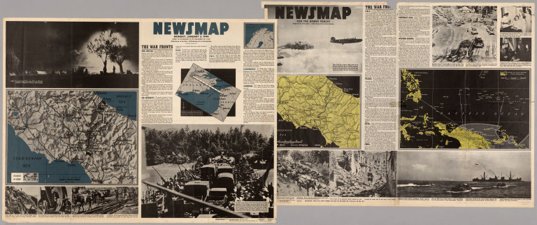
World News of the Week : Monday, Jan. 3, 1944. Covering period Dec. 24 to Dec. 30. Volume 6, No. 18. Published and copyrighted (weekly), 1944, by News Map of the Week, Inc., 1512 Orleans Street, Chicago, Illinois. Published in two sections : Section one. Lithographed in U. S. A.
List No
14152.000
Note
Lithographed world map, in color. Shows political boundaries and military events of World War II, from December 24 to 30, 1943. Relief illustrated with hachures. Descriptive text throughout, e.g.: Nazis lose three destroyers, other ships in Bay of Biscay. Map indexed according to historical notes beneath map. Features photographs, illustrations, and international time zones. With two inset maps: How New Britain compares in size with Massachusetts -- Scharnhorst. Also, with two diagrams: Total railroad mileage -- Saving the wounded. Map is 56 x 115 cm, on sheet 89 x 120 cm, folded to 31 x 23 cm.
Author
Industrial Services Division, Bureau of Public Relations, War Department
Full Title
Newsmap : Monday, January 10, 1944. Week of December 29 to January 5, 1944, 226th week of the War - 108th week of U. S. participation. Volume II No. 38. Distributed by Industrial Services Division, Bureau of Public Relations, War Department. Prepared from public sources of information. U. S. Government Printing Office: 1944.
List No
14157.000
Note
Five lithographed maps, in black, blue and white. Maps show political boundaries, rivers, and railways. Geography selected to depict military events of World War II, from December 29 to January 5, 1944. Maps: (New Britain I.) (26 x 71 cm, scale 1:1,750,000) -- (Italy) (43 x 43 cm, scale 1:750,000) -- (Cassino) (17 x 27 cm, scale 1:175,000) -- (Chieti) (23 x 27 cm, scale 1:175,000) -- (Border between Poland and Russia) (23 x 27 cm, scale 1:1,000,000). Each map includes a bar scale. Accompanying historical notes describe the war fronts: USSR -- Southwest Pacific -- Italy -- Air offensive. Features photographs. Sheet 89 x 120 cm, folded to 31 x 23 cm. Stamp on verso: Received Jan 12 1943 C. E. King.
Author
News Map of the Week, Inc.
Full Title
World News of the Week : Monday, Feb. 21, 1944. Covering period Feb. 11 to Feb. 17. Volume 6, No. 25. Published and copyrighted (weekly), 1944, by News Map of the Week, Inc., 1512 Orleans Street, Chicago, Illinois. Published in two sections : Section one. Lithographed in U. S. A.
List No
14160.000
Note
Lithographed world map, in color. Shows political boundaries and military events of World War II, from February 11 to 17, 1944. Relief illustrated with hachures. Descriptive text throughout, e.g.: Reds close in on trapped Nazis. Map indexed according to historical notes beneath map. Features photographs, illustrations, and international time zones. With inset map: (New Guinea, including New Britain Island). Map is 56 x 115 cm, on sheet 89 x 120 cm, folded to 31 x 23 cm.
Author
Army Information Branch, Army Service Forces
Full Title
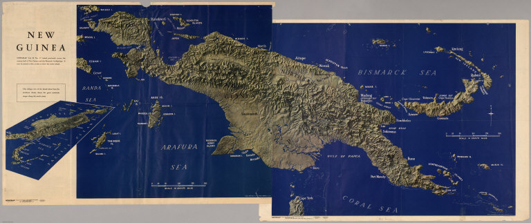
New Guinea, Newsmap Vol. II, No. 37, Vol. III, No. 68.
List No
6378.001
Note
Relief shown in shaded relief. Two map sheets put together. Double-sided. Includes oblique and vertical views of New Guinea, map of South map of central Italy (Cassino), map of Rome area, map of English Channel, text about various fronts, and dramatic war photos.
Author
Army Information Branch, Army Service Forces
Full Title
Newsmap, Monday, January 3, 1944, Week of December 22 to December 29, 1943, 225th Week of the War - 107th Week of U.S. Participation, Vol. II, No. 37. Newsmap for the Armed Forces, 246th Week of the War - 128th Week of U.S. Participation.
List No
6378.002
Note
Relief shown in shaded relief. Two map sheets put together. Double-sided. Includes oblique and vertical views of New Guinea, map of South map of central Italy (Cassino), map of Rome area, map of English Channel, text about various fronts, and dramatic war photos.
Author
Pearson, Charles
Full Title
Yank's New Guinea.
List No
8897.000
Note
Date estimated.
Author
[Drew, Anna, Qantas Empire Airways, ltd.]
Full Title
Qantas world routes. Anna Drew. Posters PTY. Ltd. Sydney. Litho in Australia.
List No
10038.000
Note
This issue is earlier than our 1950 issue - fewer air routes in Africa and Asia. Pictorial map of the world in full color, mounted on linen. Map is advertisement for Qantas Airways. Artwork depicting a pictorial map of the world, showing Australia's overseas routes and connections for Qantas in association with B.O.A.C. and T.E.A.L. Destinations feature vignettes representing the country. For Australia: black swan for Perth; koala for Australia; Sydney Harbour Bridge for Sydney. For New Zealand: Maori talisman. For Papua New Guinea: palm tree with bird of Paradise. The compass includes Aboriginal design. The brown border with the Qantas flying kangaroo logos. Includes legend. Date estimated.
Author
Hammond, C.S.
Full Title
East India Islands. 19.
List No
1954.045
Note
Includes a map of the Netherlands at the same scale as East India Islands.
Author
[Drew, Anna, Qantas Empire Airways, ltd.]
Full Title
Qantas world routes. Anna Drew. Posters PTY. Ltd. Sydney. Litho in Australia.
List No
8407.000
Note
Pictorial map of the world in full color, mounted on linen. Map is advertisement for Qantas Airways. Artwork depicting a pictorial map of the world, showing Australia's overseas routes and connections for Qantas in association with B.O.A.C. and T.E.A.L. Destinations feature vignettes representing the country. For Australia: black swan for Perth; koala for Australia; Sydney Harbour Bridge for Sydney. For New Zealand: Maori talisman. For Papua New Guinea: palm tree with bird of Paradise. The compass includes Aboriginal design. The brown border with the Qantas flying kangaroo logos. Includes legend. Date estimated.
|


