Who What Where WhenWHATShow MoreWHEREShow More |
Author
Schedel, Hartmann (1440-1514)
Full Title
(Europe) Nuremberg Chronicle) Register DES BUCHS DER CRO=NICKEN und geschichten mit figure…
List No
15906.299
Note
"The map includes one of the earliest depictions of Scandinavia and the Baltic Coast, extending to Russia in the east and Ireland and England in the west. In the south, the map extends south of the Alps to Istanbul, Venice and the northernmost coast of the Mediterranean Sea. Schedel's map is a cartographic landmark. As noted by Ginsberg, Schedel's map is perhaps best characterized as: The first modern map of northern and central Europe. The map ranges from the British Isles to Constantinopel. The designer has been identified as Hieronymus Munzer (1437-1508), who trained as a physician . . . The Munzer map is one of the earliest to depict the Scandinavia peninsula. Nordenskold credits the map of the north in the Zamoyski codes as the prototype for this map. The source for the Central European portion is a manuscript ma circa 1460 of Germany by Cardinal Nicolas Cusanus, printed posthumously at Eystatt in 1491." (Ruderman, 2021)
Author
[Ptolemy, Claudius, D'Angelo, Jacopo, Regiomontanus, Joannes, Pirckheimer, Willibald, Grueninger, Johann]
Full Title
(Tabu. Moderna Hungariae, Poloniae, Russiae, Et Valachiae)
List No
10891.098
Author
[Munster, Sebastian, 1488-1552, Ptolemy, Claudius, Pirckheimer, Willibald, 1470-1530]
Full Title
Tabula Europae VIII. (to accompany) Geographia universalis, vetus et nozva, complectens Claudii Ptolemaei Alexandrini enarrationis libros VIII ... Basileae apud Henricum Petrum Mense Martio anno M.D. XL (1540).
List No
11623.035
Note
Woodcut uncolored 8th. map of Europe, Covers Russia, Ukraine, Baltic, and part of Scandinavia. Shows cities, towns, rivers and mountains. Relief shown pictorially. Includes legend and list town names. Text and map bound out of order.
Author
[Munster, Sebastian, 1488-1552, Ptolemy, Claudius, Pirckheimer, Willibald, 1470-1530]
Full Title
Tabula Asiae VII. (to accompany) Geographia universalis, vetus et nozva, complectens Claudii Ptolemaei Alexandrini enarrationis libros VIII ... Basileae apud Henricum Petrum Mense Martio anno M.D. XL (1540).
List No
11623.053
Note
Woodcut uncolored 7th. map of Asia. Covers Central Asia and Russia. Shows cities, towns, land marks, rivers and mountains. Relief shown pictorially. Includes notes.
Author
[Ptolemy, Claudius, Fries, Lorenz, Servetus, Michael]
Full Title
Asiae Tabvla seconda continet. (to accompany) Claudii Ptolemaei Alexandrini Geographicae enarrationis libri octo. Sed ad Graeca & prisca exemplaria a Michaele Villanouano secundo recogniti & locis innumeris denuo castigati. Prostant Lugduni Apud Hugonem a Porta. M.D.XLI. (1541).
List No
11325.036
Note
Engraved map of the Black Sea, Ukraine and Southern Russia extending to the Caspian Sea.
Author
[Ptolemy, Claudius, Fries, Lorenz, Servetus, Michael]
Full Title
Tabula noua Poloniae, Vngariae, & Russiae. (to accompany) Claudii Ptolemaei Alexandrini Geographicae enarrationis libri octo. Sed ad Graeca & prisca exemplaria a Michaele Villanouano secundo recogniti & locis innumeris denuo castigati. Prostant Lugduni Apud Hugonem a Porta. M.D.XLI. (1541).
List No
11325.067
Note
Engraved modern map of Russia, Poland and Hungary.
Author
[Ptolemy, Claudius, Gastaldi, Giacomo, Mattioli, Pietro Andrea, 1500-1577, Pedrezano, Giovanbattista]
Full Title
Moschovia nova tabula. (to accompany) Ptolemeo. La geografia di Claudio Ptolemeo alessandrino ... In Venetia, ... per Gioan. Baptista Pedrezano ... Anni x. M.D.XLVIII (1548).
List No
11479.087
Note
Engraved modern map of Russian Empire, including Poland, Lithuania, Estonia and Ukraine. Shows political boundaries, cities, towns, landmarks, rivers and mountains. Relief shown pictorially.
Author
[Ptolemy, Claudius, Gastaldi, Giacomo, Mattioli, Pietro Andrea, 1500-1577, Pedrezano, Giovanbattista]
Full Title
Tabula Asiae III. (to accompany) Ptolemeo. La geografia di Claudio Ptolemeo alessandrino ... In Venetia, ... per Gioan. Baptista Pedrezano ... Anni x. M.D.XLVIII (1548).
List No
11479.089
Note
Engraved ancient map of the region between the Black and Caspian seas. Covers Armenia, Caspian Sea, Iran, Turkey, Azerbaijan and Russia. Noah's Ark is shown in the Caspian Sea. Shows boundaries, cities, towns, landmarks, rivers and mountains. Relief shown pictorially.
Author
[Ptolemy, Claudius, Ruscelli, Girolamo, Giuseppe Moletti, M.]
Full Title
Tabvla Asiae II. Dell' Asia, Tavola Seconda antica. (To accompany) La geografia di Claudio Tolomeo Alessandrino, nuouamente tradotta di Greco in Italiano, da Girolamo Ruscelli ... In Venetia, Appresso Vincenzo Valgrisi, M.D.LXI. (1561).
List No
11311.040
Note
Engraved map of ancient region of Asiatic Sarmatia, now Southern Russia and part of Ukraine, around the Azov sea. Relief shown pictorially.
Author
[Ptolemy, Claudius, Ruscelli, Girolamo, Giuseppe Moletti, M.]
Full Title
Moschovia nvova tavola. Moscovia, Decima Tavola Nvova. (To accompany) La geografia di Claudio Tolomeo Alessandrino, nuouamente tradotta di Greco in Italiano, da Girolamo Ruscelli ... In Venetia, Appresso Vincenzo Valgrisi, M.D.LXI. (1561).
List No
11311.087
Note
Engraved map of modern day Russia and the Ukraine, covers the region north of the Black and Caspian Seas, with Moscow near the center. Relief shown pictorially.
Author
Ortelius, Abraham, 1527-1598
Full Title
Septentrionalium Regionum Descrip. Cum privilegio.
List No
10000.099
Author
Ortelius, Abraham, 1527-1598
Full Title
Russia aut potius Magni Ducis Moscoviae Imperium. 46
List No
10000.100
Author
Ortelius, Abraham, 1527-1598
Full Title
Russiae, Moscoviae Et Tartariae Descriptio. Auctore Antonio Ienkensono Anglo, edita Londini Anno 1562 & dedicata illustriss. D. Henrico Sijdneo Walliei presidi. Cum privilegio.
List No
10000.101
Note
8 blocks of text, 3 within cartouches.
Author
Ortelius, Abraham, 1527-1598
Full Title
Tatariae Sive Magni Chami Regni typus. Cum Privilegio.
List No
10000.103
Author
Munster, Sebastian, 1488-1552
Full Title
Russia
List No
15058.211
Author
Munster, Sebastian, 1488-1552
Full Title
Sarmatia Asiatica
List No
15058.220
Author
Speckle, Daniel
Full Title
Elsass ist der Vier provintzen eine im teutschen Landt, ist erstlichen von den Babilonieren bewohnt, von S. Matherno S. Petterus Junger zum Christen glauben formen, ist das schönste thall in Germania... ; Gestellt von Daniel Speckel von Strasbourg . . .
List No
10724.000
Note
On the left side of the map three areas that were missing in the original have been filled in from a lower resolution digital copy.
Author
Monte (Monti), Urbano, 1544-1613
Full Title
Tavola Seconda. Libro Terzo.
List No
10130.004
Author
Bunting, Heinrich
Full Title
Europe in the Shape of a Queen) Europa Prima Pars Terrae In Forma Virginis . . .
List No
15301.005
Note
"Protestant theologian Heinrich Bunting's map showing Europe as a queen is one of the most sought after anthropomorphic maps of the 16th Century. The depiction of Europe as a queen began in the 14th Century. Europe was named for princess Europa (Daughter of Phoenicia), who had been carried off and raped by Zeus. The earliest depiction of Europe as a woman is believed to be by the 14th Century Pavian Cleric Opicinus de Canistris for the papal court, then at Avignon. The woman represents the Mother Church, who is being seduced from the true path. In 1537 the Tirolese cartographer Johann Putsch celebrated the Hapsburg rule over Europe by presenting a placid "Europa Regina" wearing Charles V's Spain as a crown and Ferdinand's Austria as a medal at her waist, representing the triumph of the Hapsburgs. The queen's crown (Spain), orb (Sicily), and heart (Bohemia), form a triangle that directs the viewer's eye away from eastern Europe toward the West. The British Isles are a shapeless blob perched near her shoulder. Her skirt is composed of the Baltics and Greece; Turkey and Russia are beneath her feet. Later editions of Europe as a queen were issued by Sebastian Münster, Heinrich Bunting, and Matthias Quad." (Ruderman, 2022)
Author
Quad, Matthias, 1557-1613
Full Title
17. Prussiae Descriptio.
List No
9690.042
Author
Quad, Matthias, 1557-1613
Full Title
68. Moscoviae Imperium.
List No
9690.144
Author
[Mercator, Gerhard, 1512-1594, Hondius, Jodocus, 1563-1612]
Full Title
(Text page to) Russia, sive Moscovia.
List No
10501.141
Author
[Mercator, Gerhard, 1512-1594, Hondius, Jodocus, 1563-1612]
Full Title
Russia cum confinijs. Per Gerardum Mercatorem Cum Privilegio.
List No
10501.142
Author
[Mercator, Gerhard, 1512-1594, Hondius, Jodocus, 1563-1612]
Full Title
(Text page to) (con't) Russia, sive Moscovia.
List No
10501.143
Author
[Mercator, Gerhard, 1512-1594, Hondius, Jodocus, 1563-1612]
Full Title
(Text page to) Lithuania Ducatus, Samogitia, Russia, et Volhinia.
List No
10501.144
Author
[Mercator, Gerhard, 1512-1594, Hondius, Jodocus, 1563-1612]
Full Title
(Text page to) (con't) Lithuania Ducatus, Samogitia, Russia, et Volhinia.
List No
10501.146
Author
[Mercator, Gerhard, 1512-1594, Hondius, Jodocus, 1563-1612]
Full Title
Taurica Chersonesus. Nostra aetate Przecopsca et Gazara dicitur. Per Gerardum Mercatorem Cum Privilegio.
List No
10501.151
Author
[Mercator, Gerhard, 1512-1594, Hondius, Jodocus, 1563-1612]
Full Title
Tartaria. Jodocus Hondius lectori salutem In hac Tartariae descriptione omnem adhibuimus diligentiam ut ... quoddam.
List No
10501.484
Author
[Mercator, Gerhard, 1512-1594, Hondius, Iodocus, 1563-1612]
Full Title
Livonia. (to accompany) Atlas minor Gerardi Mercatoris.
List No
11201.099
Note
Map of northern Baltic region. Covers west to Poland, Estonia, Latvia and part of Russia.
Author
[Mercator, Gerhard, 1512-1594, Hondius, Iodocus, 1563-1612]
Full Title
(Text Page to) Russia, Siue Moscouia. (to accompany) Atlas minor Gerardi Mercatoris.
List No
11201.104
Note
Text to map of Russia cum Confinijs.
Author
[Mercator, Gerhard, 1512-1594, Hondius, Iodocus, 1563-1612]
Full Title
Russia cum Confinijs. (to accompany) Atlas minor Gerardi Mercatoris.
List No
11201.105
Note
Map of Russia. Relief shown pictorially.
Author
[Mercator, Gerhard, 1512-1594, Hondius, Iodocus, 1563-1612]
Full Title
(Text Page to) Russia, Siue Moscouia. (to accompany) Atlas minor Gerardi Mercatoris.
List No
11201.106
Note
Text to map of Russia cum Confinijs.
Author
[Mercator, Gerhard, 1512-1594, Hondius, Iodocus, 1563-1612]
Full Title
Moscovia. (to accompany) Atlas minor Gerardi Mercatoris.
List No
11201.107
Note
Map of Moscow. Relief shown pictorially.
Author
[Mercator, Gerhard, 1512-1594, Hondius, Iodocus, 1563-1612]
Full Title
(Text Page to) Russia, Siue Moscouia. (to accompany) Atlas minor Gerardi Mercatoris.
List No
11201.108
Note
Text to map of Moscovia.
Author
[Ortelius, Abraham, 1527-1598, Vrients, Jan Baptista]
Full Title
Septentrionalium Regionum Descrip. Cum privilegio.
List No
10001.296
Author
[Ortelius, Abraham, 1527-1598, Vrients, Jan Baptista]
Full Title
(Text Page) La Russia, Overo Piu Tosto Il Dominio Del Gran Duca Di Moscovia. 116
List No
10001.300
Author
[Ortelius, Abraham, 1527-1598, Vrients, Jan Baptista]
Full Title
Russiae, Moscoviae Et Tartariae Descriptio. Auctore Antonio Ienkensono Anglo, edita Londini Anno 1562 & dedicata illustriss. D. Henrico Sijdneo Walliei presidi. Cum privilegio.
List No
10001.301
Note
8 blocks of text, 3 within cartouches.
Author
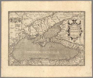
[Ortelius, Abraham, 1527-1598, Vrients, Jan Baptista]
Full Title
Pontos Eukseinos. Pontus Euxinus. Aequor Iasonis pulsatum remige primum. Cum Privilegio Imp. Reg. et Belgico, Ad decennium. 1590.
List No
10001.401
Note
Part of the Parergon.
Author
Blaeu, Willem Janszoon, 1571-1638
Full Title
(Covers to) Licht der Zeevaert.
List No
14351.001
Note
Covers to Het Licht der Zee-vaert. Calf binding with richly gilded spine compartments and title. Title translates (loosely) to: Light of the sea.
Author
Blaeu, Willem Janszoon, 1571-1638
Full Title
(Title Page to) Het Licht der Zee-vaert daerinne claersyck beschreven ende afghebeeldet werdé, alle de Custen end Havenen; vande Westersche, Noordsche, Oostersche ende Middelandsche Zee'n. Dock van vele Landen, Eylanden ende plaetsen van Guinea, Brasilien, Oost ende West-Indien. Wt de alderbeste Zeebeschryvers gheschriften (als Locas Ians z. Waghenaer ende meer andere) eenfdeels vergadert: maer uyt vele ervarene Zeevaerders schriften ende mondtlycke verclaringhen van alle verlopen ghebetert, ende met veel nieuwe beschryvinghen ende Caerten seer vermeerdert. Alles ghedeelt in vier boecken, waer van yders inhoudt voor elck uytghedruckt staet. Hier zyn byghevoeght (beneffens eene onderwysinghe in de conste der Zeevaert) nieuwe tafelen van der zonnen declinatie, gherekent uyt de observation van Tyche Brahe, ende gherecht op de Meridiaen van Amsterdam. Midsgaders nieuwe tafelenende onderwys van't recht ghebruyck der Noordsterre ende andere vaste sterren alle Zeevarende luyden te nut ghedaen. Door Willem Ians Zoon. Tot Amsterdam. Anno 1620.
List No
14351.002
Note
Title page to Het Licht der Zee-vaert. Includes an engraved illustration of two figures, as well as a view showing the port of Amsterdam. Title translates (loosely) to: The Light of the Sea, which is described and depicted; all the coasts and the ports of the Western, Northern, Eastern and Mediterranean Seas. Docks of many countries, islands and the places of Guinea, Brazil, East and the West Indies. With the best sea writings … with many new descriptions … Everything is divided into four books … Here are new tables of the sun’s declination, based on the observation of Tyche Brahe …
Author
[Blaeu, Willem Janszoon, 1571-1638, Hooft, P. C. (Pieter Corneliszoon), 1581-1647]
Full Title
(Text Page to) Klinkckdicht, op her licht der zeevaert. Z. H. -- Op het licht der zeevaert. P. C. Hooft.
List No
14351.003
Note
Two introductory texts to Het Licht der Zee-vaert. Second page includes an engraved lion. Titles translate (loosely) to: In the light of the seafarer.
Author
Blaeu, Willem Janszoon, 1571-1638
Full Title
[View of seafarers].
List No
14351.004
Note
View showing a group of men using globes, maps and other tools to chart navigational plans, with a roiling sea in the background, sailed by numerous vessels. Black and white engraving. View is 23 x 27 cm, on sheet 26 x 29 cm. (Title supplied by cataloger.)
Author
Blaeu, Willem Janszoon, 1571-1638
Full Title
(Text Page to) Loste ende clare Inleydinghe tot het verstrent de Hemelsche Sphera, in soo veele, als tot de conste der Zeebaert van noode is. (1)
List No
14351.005
Note
First section to Het Licht der Zee-vaert. Title translates (loosely) to: To the farthest end of the celestial sphere ... Includes chapter: I. Van de Polen der Werelt [= Of the poles of the world]. With historiated initial. Features engraved diagram showing the earth on its axis.
Author
Blaeu, Willem Janszoon, 1571-1638
Full Title
(Text Page to) Loste ende clare Inleydinghe tot het verstrent de Hemelsche Sphera, in soo veele, als tot de conste der Zeebaert van noode is. (2)
List No
14351.006
Note
First section to Het Licht der Zee-vaert. Title translates (loosely) to: To the farthest end of the celestial sphere ... Includes chapters: Capittel II. Van de Linie Æquinoetiael [= Equinoctial line]. -- Capittel III. Vande Tropicken en den Zodiac [= Lines of the tropics and the zodiac]. Features engraved diagram showing the earth on its axis, along with the zodiac positions.
Author
Blaeu, Willem Janszoon, 1571-1638
Full Title
Caarte Vande Reede ende Haven van Medenblick, hoemen die ... Anno 1614.
List No
14351.007
Note
Nautical chart showing the harbor of Medemblick (Netherlands). Features cities, roads, ports, coastline, shoals, islands, anchorage, soundings and ships. Relief shown pictorially. Includes rhumb lines and compass roses, with north oriented toward lower right. Decorative cartouches. Black and white engraving. Chart is 25 x 55 cm, on double sheet 26 x 58 cm.
Author
Blaeu, Willem Janszoon, 1571-1638
Full Title
(Text Page to) Loste ende clare Inleydinghe tot het verstrent de Hemelsche Sphera, in soo veele, als tot de conste der Zeebaert van noode is. (3)
List No
14351.008
Note
First section to Het Licht der Zee-vaert. Title translates (loosely) to: To the farthest end of the celestial sphere ... Includes chapters: Capittel III. Vande Tropicken en den Zodiac [= Lines of the tropics and the zodiac]. -- Capittel IV. Van den loop der Sonnen [= Course of the Sun] -- Capittel V. Van de declinatie der Sonnen [= Declination of the Sun].
Author
Blaeu, Willem Janszoon, 1571-1638
Full Title
(Text Page to) Loste ende clare Inleydinghe tot het verstrent de Hemelsche Sphera, in soo veele, als tot de conste der Zeebaert van noode is. (4)
List No
14351.009
Note
First section to Het Licht der Zee-vaert. Title translates (loosely) to: To the farthest end of the celestial sphere ... Includes chapter: Capittel VI. Hoemen alle daghen de declinatie des Sons vinden sal [= How every day they find the declination of the Sun]. Features engraved illustration of the sun.
Author
Blaeu, Willem Janszoon, 1571-1638
Full Title
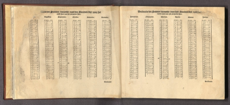
(Text Page to) Declinatie der Sonnen ... (1)
List No
14351.010
Note
Table within Het Licht der Zee-vaert. Title translates (loosely) to: Declination of the Sun. Covers the months of January through June, with figures recorded for each date. Includes manicules pointing out the spring equinox in the calendar.
Author
Blaeu, Willem Janszoon, 1571-1638
Full Title
(Text Page to) Declinatie der Sonnen ... (2)
List No
14351.011
Note
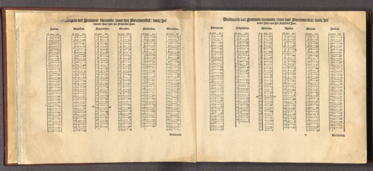
Table within Het Licht der Zee-vaert. Title translates (loosely) to: Declination of the Sun. Covers the months of July through June, with figures recorded for each date. Includes manicules pointing out both the autumnal and spring equinoxes in the calendar.
Author
Blaeu, Willem Janszoon, 1571-1638
Full Title
(Text Page to) Declinatie der Sonnen ... (3)
List No
14351.012
Note
Table within Het Licht der Zee-vaert. Title translates (loosely) to: Declination of the Sun. Covers the months of July through June, with figures recorded for each date. Includes manicules pointing out both the autumnal and spring equinoxes in the calendar.
|


![[View of seafarers].](https://www.davidrumsey.com/rumsey/Size2/RUMSEY~8~1/195/14351004.jpg)