Who What Where WhenWHATShow MoreWHERE
|
Author
[Chatelain Henri, 1684-1743, Gueudeville, Nicolas]
Full Title
Carte de la Nouvelle France, ou se voit le cours des grandes rivieres de S. Laurens & de Mississipi aujour d'hui S. Louis, aux environs des-quelles se trouvent les etats, païs, nations, peuples &c. de la Floride, de la Louisiane, de la Virginie, de la Marie-Lande, de la Pensilvanie, du Nouveau Jersay, de la Nouvelle Yorck, de la Nouv. Angleterre, de l'Acadie, du Canada, des Esquimaux, des Hurons, des Iroquois, des Ilinois &c. et de la grande ile de Terre Neuve : dressee sur les memoires les plus nouveaux recueillis pour l'etablissement de la Compagnie Françoise Occident. Tom. VI. No. 23. Page 90. (to accompany) Atlas Historique ... Tome VI. A Amsterdam, chez L'Honore & Chatelain Libraires. M DCC XIX (1719).
List No
13272.687
Note
Engraved folded map, depiction of the Mississippi Delta and Mobile Bay, based upon the 1699 voyage of Pierre Le Moyne d'Iberville. Shows New England and eastern Canada. Includes plan and views of Quebec in decorative cartouche. Map is filled with engraved wildlife, scenes of Indians hunting, Indian villages, numerous ships, canoes and sea monsters and notations.
Author
[Seutter, Matthaeus, 1678-1756, Rogg, Gottfried, 1669-1742]
Full Title
Accurata delineatio celeberrimae Regionis Ludovicianae vel Gallice Louisiane ol. Canadae et Floridae Adpellatione in Septemtrionali America Descriptae quae Hodie Nomine Fluminis Mississippi vel St. Louis . . . edita cura et manu Matthaei Seutteri, Chalcog. Augustan. ; Gottfr. Rogg, del. M. Rhein, sc.(inset) "Les costes de la Louisiane depuis la baye de Ascension jusques acelle de S. Joseph.
List No
8155.000
Note
Hand colored map of Seutter's Mississippi Bubble map, depicting the short-lived French financial-colonial scheme masterminded by Scottish financier John Law. Map shows early eighteenth century geography, settlements, and territories in North America focusing on the Mississippi River and the Great Lakes. Relief shown pictorially. Includes historical notes and distant chart. A large inset of the Gulf Coast shows many forts and Indian villages. Elaborate title cartouche, depicts an allegorical, satirical scene of the infamous Mississippi Bubble investment scheme with a female personification of the Mississippi River pouring jewels and riches forth, while she is perched precariously upon a bubble. Cherubs above the cartouche are issuing stock for the company, and another group is blowing bubbles in the foreground surrounded by piles of worthless stocks. In the background, desperate investors climb a small tree and fling themselves out of it, and in the foreground more disconsolate investors wail and bemoan their fates as one tries to impale himself on his sword. Above them, a cherub upends an empty money-bag.
Author
Popple, Henry
Full Title
A Map of the British Empire in America with the French and Spanish Settlements adjacent thereto. by Henry Popple. (Sheet 5).
List No
2874.007
Note
Uncolored map includes the area from Taos, NM in the southwest to the edge of Lake Superior in the northeast. Copper mines, Indian tribes and villages, falls on the Mississippi River, and missions shown.
Author
Popple, Henry
Full Title
A Map of the British Empire in America with the French and Spanish Settlements adjacent thereto. by Henry Popple. (Sheet 5).
List No
5810.013
Note
Colored map includes the area from Taos, NM in the southwest to the edge of Lake Superior in the northeast. Copper mines, Indian tribes and villages, falls on the Mississippi River, and missions shown.
Author
[Mitchell, John, Raynal, G.T., Zatta, Antonio]
Full Title
Il Paese de' Cherachesi, con la Parte Occidentale della Carolina Settentrionale, e della Virginia. Fogl. VII.
List No
5007.009
Note
In outline color.
Author
Hutchins, Thomas
Full Title
A New Map of the Western Parts of Virginia, Pennsylvania, Maryland and North Carolina; Comprehending the River Ohio, and all the Rivers, which fall into it; Part of the River Mississippi, the Whole of the Illinois River, Lake Erie; Part of the Lakes Huron, Michigan &c. And all the Country bordering on these Lakes and Rivers. By Thos. Hutchins, Captain in the 60 Regiment of Foot. London, Published according to Act of Parliament Novembr. ye 1st, 1778 by T. Hutchins ... Engrav'd by T. Cheevers.
List No
5044.000
Note
This map was published separately and at the same time as Hutchins' "Topographical Description..." and should accompany the book. Streeter calls it "by far the best map of the west printed to that time." It was the first large scale map of the area west of the Allegheny Mountains based on personal observations, although Hutchins gives credit to Lewis Evans' "Map of the Middle Colonies" as the best prior source of information about the area. The map contains extensive printed notes which describe important aspects of the country depicted. This map ranks with the most important American maps issued in the 18th century and is now rare. Hutchins later became the first Geographer of the United States. With outline color. Map is dissected into 32 sections and mounted on linen. Folds into new green cloth folding boards and quarter leather green cloth slip case 24x16 with "Hutchin's New Map Of Western Parts Of Virginia, Etc. 1778" on the spine in gold.
Author
Zatta, Antonio, active 1757-1797
Full Title
Il Paese de' Cherachesi, con la Parte Occidentale della Carolina Settentrionale, e della Virginia. Le Colonie Unite dell' America Settentrle. Fogl. VII. (to accompany) Atlante novissimo ... Tomo IIII. Con privilegio dell Eccelimo Senato. (tomo I-IV).
List No
11598.231
Note
Engraved hand-colored in outline, double-page map. The first edition of Zatta's twelve sheet version of Mitchell's Map of North America, plus three other maps: Il Canada, La Baja D' Hudson, and Le Isole di Terra Nuova e Capo Breton. Zatta's version of Mitchell is not an exact copy: many geographical changes are introduced, and Bermuda is depicted as well as Jamaica, neither of which are shown by Mitchell. Maps showing administrative divisions, settlements, cities, towns, forts, Indian settlements, bridges, canals, mountains and rivers. Relief shown pictorially and by hacures. Includes notations.
Author
Zatta, Antonio, active 1757-1797
Full Title
Il Maryland, il Jersey Meridionale, la Delaware, e la Parte Orientale della Virginia, e Carolina Settentrionale. Le Colonie Unite dell' America Settentrle. Fogl. VIII. (to accompany) Atlante novissimo ... Tomo IIII. Con privilegio dell Eccelimo Senato. (tomo I-IV).
List No
11598.232
Note
Engraved hand-colored in outline, double-page map. The first edition of Zatta's twelve sheet version of Mitchell's Map of North America, plus three other maps: Il Canada, La Baja D' Hudson, and Le Isole di Terra Nuova e Capo Breton. Zatta's version of Mitchell is not an exact copy: many geographical changes are introduced, and Bermuda is depicted as well as Jamaica, neither of which are shown by Mitchell. Maps showing administrative divisions, settlements, cities, towns, forts, Indian settlements, bridges, canals, mountains and rivers. Relief shown pictorially and by hacures. Includes notations.
Author
Morse, Jedidiah
Full Title
A Map of the Back Settlements. Published, July 30, 1794 by I. Stockdale, Piccadilly.
List No
0632.017
Note
Uncolored map spanning the region from the eastern edge of Pennsylvania to the Mississippi River.
Author
Scott, Joseph
Full Title
N.W. Territory.
List No
0887.016
Note
Uncolored.
Author
Scott, Joseph
Full Title
S.W. Territory.
List No
0887.017
Note
Uncolored.
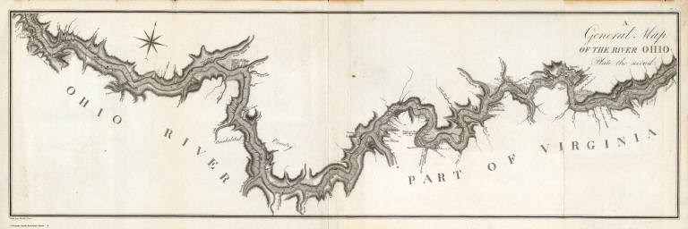
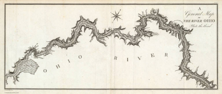
Author
[Collot, George Henri Victor, Tardieu, P.F.]
Full Title
A General Map of the River Ohio, Plate the first. Grave par Tardieu l'aine. PL. 8.
List No
4664.006
Note
These four maps show the Ohio River from Pittsburgh to the Mississippi, at a very large scale, and would make a map over ten feet long if joined end to end. These maps of the Ohio are the best and most original maps in the atlas: "The beautifully executed map of the Ohio River depicts vividly the wilderness that this country was at the time of his journey" (Wagner Camp). The level of detail is great: individual farms are shown with the owner's names, soundings for the entire river length, towns and villages, swamps, natural curiosities, rapids, and much else. When compared with Zadock Cramer's maps of the river in his "Navigator," the Collot maps are much superior, containing far more information on the river depths and surrounding shores and islands. Thomas Hutchins large map shows the Ohio well, but only at about one fourth the scale of the Collot maps; Andrew Ellicott's two maps of the river, at about one third the Collot scale, leave large stretches to conjecture. As an 1805 printing of a 1796 journey, these maps are without equal in depicting the early settlements on the Ohio. Without color.
Author
[Collot, George Henri Victor, Tardieu, P.F.]
Full Title
A General Map of the River Ohio, Plate the second. Grave par Tardieu l'aine. PL. 9.
List No
4664.007
Note
These four maps show the Ohio River from Pittsburgh to the Mississippi, at a very large scale, and would make a map over ten feet long if joined end to end. These maps of the Ohio are the best and most original maps in the atlas: "The beautifully executed map of the Ohio River depicts vividly the wilderness that this country was at the time of his journey" (Wagner Camp). The level of detail is great: individual farms are shown with the owner's names, soundings for the entire river length, towns and villages, swamps, natural curiosities, rapids, and much else. When compared with Zadock Cramer's maps of the river in his "Navigator," the Collot maps are much superior, containing far more information on the river depths and surrounding shores and islands. Thomas Hutchins large map shows the Ohio well, but only at about one fourth the scale of the Collot maps; Andrew Ellicott's two maps of the river, at about one third the Collot scale, leave large stretches to conjecture. As an 1805 printing of a 1796 journey, these maps are without equal in depicting the early settlements on the Ohio. Without color.
Author
[Collot, George Henri Victor, Tardieu, P.F.]
Full Title
A General Map of the River Ohio, Plate the third. Grave par Tardieu l'aine. PL. 10.
List No
4664.008
Note
These four maps show the Ohio River from Pittsburgh to the Mississippi, at a very large scale, and would make a map over ten feet long if joined end to end. These maps of the Ohio are the best and most original maps in the atlas: "The beautifully executed map of the Ohio River depicts vividly the wilderness that this country was at the time of his journey" (Wagner Camp). The level of detail is great: individual farms are shown with the owner's names, soundings for the entire river length, towns and villages, swamps, natural curiosities, rapids, and much else. When compared with Zadock Cramer's maps of the river in his "Navigator," the Collot maps are much superior, containing far more information on the river depths and surrounding shores and islands. Thomas Hutchins large map shows the Ohio well, but only at about one fourth the scale of the Collot maps; Andrew Ellicott's two maps of the river, at about one third the Collot scale, leave large stretches to conjecture. As an 1805 printing of a 1796 journey, these maps are without equal in depicting the early settlements on the Ohio. Without color.
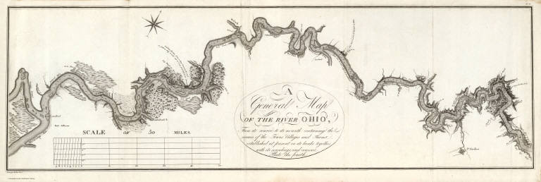
Author
[Collot, George Henri Victor, Tardieu, P.F.]
Full Title
A General Map Of The River Ohio, From its source to its mounth (sic): containing the names of the Towns Villages and Farms established at present on its banks: together with its soundings, and courses. Plate the fourth. Grave par Tardieu l'aine. PL. 11.
List No
4664.009
Note
This map contains the title cartouche for this map and the three proceeding. It also contains the scale measure. These four maps show the Ohio River from Pittsburgh to the Mississippi, at a very large scale, and would make a map over ten feet long if joined end to end. These maps of the Ohio are the best and most original maps in the atlas: "The beautifully executed map of the Ohio River depicts vividly the wilderness that this country was at the time of his journey" (Wagner Camp). The level of detail is great: individual farms are shown with the owner's names, soundings for the entire river length, towns and villages, swamps, natural curiosities, rapids, and much else. When compared with Zadock Cramer's maps of the river in his "Navigator," the Collot maps are much superior, containing far more information on the river depths and surrounding shores and islands. Thomas Hutchins large map shows the Ohio well, but only at about one fourth the scale of the Collot maps; Andrew Ellicott's two maps of the river, at about one third the Collot scale, leave large stretches to conjecture. As an 1805 printing of a 1796 journey, these maps are without equal in depicting the early settlements on the Ohio. Without color.
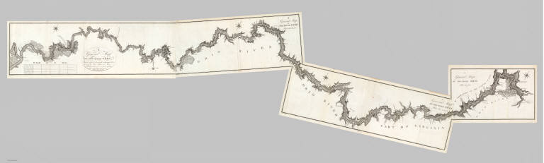
Author
[Collot, George Henri Victor, Tardieu, P.F.]
Full Title
(Composite of) A General Map Of The River Ohio, From its source to its mounth (sic): containing the names of the Towns Villages and Farms established at present on its banks: together with its soundings, and courses. (Plates one through four.) Grave par Tardieu l'aine. PL. 8-11.
List No
4664.010
Note
These four maps show the Ohio River from Pittsburgh to the Mississippi, at a very large scale, and would make a map over ten feet long if joined end to end. These maps of the Ohio are the best and most original maps in the atlas: "The beautifully executed map of the Ohio River depicts vividly the wilderness that this country was at the time of his journey" (Wagner Camp). The level of detail is great: individual farms are shown with the owner's names, soundings for the entire river length, towns and villages, swamps, natural curiosities, rapids, and much else. When compared with Zadock Cramer's maps of the river in his "Navigator," the Collot maps are much superior, containing far more information on the river depths and surrounding shores and islands. Thomas Hutchins large map shows the Ohio well, but only at about one fourth the scale of the Collot maps; Andrew Ellicott's two maps of the river, at about one third the Collot scale, leave large stretches to conjecture. As an 1805 printing of a 1796 journey, these maps are without equal in depicting the early settlements on the Ohio. Without color.
Author
Carey, Mathew
Full Title
N. W. Territory. W. Barker sculp.
List No
4865.012
Note
Uncolored.
Author
Carey, Mathew
Full Title
A Map of part of the N: W: Territory of the United States: compiled from Actual Surveys, and the best Information, by Samuel Lewis 1796. W. Barker sculp.
List No
4863.047
Note
Uncolored except in small parts.
Author
Carey, Mathew
Full Title
Louisiana.
List No
4863.050
Note
Uncolored except for a few islands.
Author
[Kensett, Thomas, Tardieu, P.F.]
Full Title
To the officers of the Army and the citizens of the United States this map of Upper and Lower Canada and United States, contigious (sic). Contracted from the manuscript surveys of P.F. Tardieu. Is respectfully inscribed by the public's most obedient servant Thomas Kensett. Copyright secured and entered ... November 4th, 1812. Kensett sculp. Cheshire, Conn.
List No
4446.000
Note
This is the only War of 1812 map in the Streeter sale. It covers the area of conflict along the U.S. and Canadian border, showing forts on the U.S. side and a great deal of detail on Canadian townships with a separate listing of towns in the various districts. The Karpinski copy adds Doolittle as engraver. The following year Kensett with Shelton put out a more general map of the U.S. showing vignettes of sea battles. Outline color. Not in Phillips. Scarce.
Author
Carey, Mathew
Full Title
The Upper Territories of the United States. Kneass & Delleker Sc.
List No
4577.025
Note
Outline color by territory. U.S. land is marked.
Author
[Carey, Mathew, Warner, Benjamin]
Full Title
The Middle States and Western Territories of the United States, Including The Seat of the Western War. 1812. Philadelphia: Published By M. Carey, And B. Warner. 1816.
List No
4864.008
Note
Prime meridian is from Philadelphia. Relief shown by hachures.
Author
[Carey, Mathew, Warner, Benjamin]
Full Title
The Northwestern Territories of the United States. Philadelphia: Published By M. Carey, And B. Warner. 1816.
List No
4864.010
Note
Prime meridians are from London and Philadelphia. Relief shown by hachures.
Author
Carey, Mathew
Full Title
The Upper Territories of the United States. Kneass & Delleker Sc.
List No
2721.030
Note
Outline color by territory. U.S. land is marked. Prime meridians Philadelphia and London. Relief shown by hachures.
Author
[Carey, H. C., Lea, I.]
Full Title
Geographical, Historical, And Statistical Map Of Arkansas Territory. Map Of Arkansas And Other Territories of the United States Respectfully inscribed to the Hon. J.C. Calhoun Secretary Of War By S.H. Long Major T. Engineers. No. 35. Drawn by S.H. Long Maj. U.S. Engineers. Engraved by Young & Delleker.
List No
0122.030
Note
In full color by region surrounded by text.
Author
[James, Edwin, Long, Stephen H.]
Full Title
(Title Page to) Account of An Expedition From Pittsburgh to the Rocky Mountains, Performed in the Years 1819 and 1820 ... Maps and Plates. Philadelphia: H.C. Carey and I. Lea, Chesnut Street. 1822. (Accompaniment to) Account of An Expedition From Pittsburgh to the Rocky Mountains, Performed in the Years 1819 and 1820...Under the Command of Major Stephen H. Long. From the Notes of Major Long, Mr. T. Say, and Other Gentlemen of the Exploring Party. Compiled by Edwin James ... In Two Volumes. - With An Atlas. Philadelphia: H.C. Carey & I. Lea, Chestnut St. 1823.
List No
0343A
Note
Long's map of the great plains and the rivers draining east from the Rocky Mountains was the best depiction done at that time and was used by other map makers (see Carey and Lea atlas). Maps bound separately. Atlas vol is dated 1822, text vols 1823, all as originally issued (see Howes). Both text volumes bound in leather with "Long's First Expedition" and volume number in gilt on spines. Atlas volume rebound with quarter leather and cloth covered boards. Two large maps entitled: "Country drained by the Mississippi Eastern Section" and "...Western Section."
Author
[James, Edwin, Long, Stephen H.]
Full Title
(Contents Page to) Account of An Expedition From Pittsburgh to the Rocky Mountains, Performed in the Years 1819 and 1820 ... Maps and Plates. Philadelphia: H.C. Carey and I. Lea, Chesnut Street. 1822. (Accompaniment to) Account of An Expedition From Pittsburgh to the Rocky Mountains, Performed in the Years 1819 and 1820...Under the Command of Major Stephen H. Long. From the Notes of Major Long, Mr. T. Say, and Other Gentlemen of the Exploring Party. Compiled by Edwin James ... In Two Volumes. - With An Atlas. Philadelphia: H.C. Carey & I. Lea, Chestnut St. 1823.
List No
0343.005
Note
Long's map of the great plains and the rivers draining east from the Rocky Mountains was the best depiction done at that time and was used by other map makers (see Carey and Lea atlas). Maps bound separately. Atlas vol is dated 1822, text vols 1823, all as originally issued (see Howes). Both text volumes bound in leather with "Long's First Expedition" and volume number in gilt on spines. Atlas volume rebound with quarter leather and cloth covered boards. Two large maps entitled: "Country drained by the Mississippi Eastern Section" and "...Western Section."
Author
[James, Edwin, Long, Stephen H.]
Full Title
(Contents Page (2) to) Account of An Expedition From Pittsburgh to the Rocky Mountains, Performed in the Years 1819 and 1820 ... Maps and Plates. Philadelphia: H.C. Carey and I. Lea, Chesnut Street. 1822. (Accompaniment to) Account of An Expedition From Pittsburgh to the Rocky Mountains, Performed in the Years 1819 and 1820...Under the Command of Major Stephen H. Long. From the Notes of Major Long, Mr. T. Say, and Other Gentlemen of the Exploring Party. Compiled by Edwin James ... In Two Volumes. - With An Atlas. Philadelphia: H.C. Carey & I. Lea, Chestnut St. 1823.
List No
0343.006
Note
Long's map of the great plains and the rivers draining east from the Rocky Mountains was the best depiction done at that time and was used by other map makers (see Carey and Lea atlas). Maps bound separately. Atlas vol is dated 1822, text vols 1823, all as originally issued (see Howes). Both text volumes bound in leather with "Long's First Expedition" and volume number in gilt on spines. Atlas volume rebound with quarter leather and cloth covered boards. Two large maps entitled: "Country drained by the Mississippi Eastern Section" and "...Western Section."
Author
[James, Edwin, Long, Stephen H.]
Full Title
Country drained by the Mississippi Eastern Section. (with) Country of the Mississippi. (with) Profile or Vertical Section of the Country on the Parallel of Latitude 38 degrees North. Drawn by S.H. Long Maj. T. Engineers. Engrav'd by Young & Delleker. For the Expedition to the Rocky Mountains Vol. I.
List No
0343.001
Note
A large uncolored map stretching from Mississippi to Lake Superior. An inset box at top right includes a series of explanations to the symbols on the map.
Author
[James, Edwin, Long, Stephen H.]
Full Title
Country drained by the Mississippi Western Section. (with) Profile or Vertical Section of the Country on the Parallel of Latitude 38 degrees North. Drawn by S.H. Long Maj. T. Engineers. Engrav'd by Young & Delleker. For the Expedition to the Rocky Mountains Vol. I.
List No
0343.002
Note
Uncolored map showing the region from Arkansas, the Spanish Territory, and north to the Black Hills.
Author
[James, Edwin, Long, Stephen H.]
Full Title
(Composite Map of) Country drained by the Mississippi Eastern Section (and) Western Section. Drawn by S.H. Long Maj. T. Engineer. Engrav'd by Young & Delleker.
List No
0343.004
Note
Uncolored composite map. The London edition of Long joins the two maps into one.
Author
[James, Edwin, Long, Stephen H.]
Full Title
War Dance in the Interior of a Konza Lodge.
List No
0343.007
Note
Long's map of the great plains and the rivers draining east from the Rocky Mountains was the best depiction done at that time and was used by other map makers (see Carey and Lea atlas). Maps bound separately. Atlas vol is dated 1822, text vols 1823, all as originally issued (see Howes). Both text volumes bound in leather with "Long's First Expedition" and volume number in gilt on spines. Atlas volume rebound with quarter leather and cloth covered boards. Two large maps entitled: "Country drained by the Mississippi Eastern Section" and "...Western Section."
Author
[James, Edwin, Long, Stephen H.]
Full Title
View of the Rocky Mountains, on the Platte, 50 miles from their base.
List No
0343.008
Note
Long's map of the great plains and the rivers draining east from the Rocky Mountains was the best depiction done at that time and was used by other map makers (see Carey and Lea atlas). Maps bound separately. Atlas vol is dated 1822, text vols 1823, all as originally issued (see Howes). Both text volumes bound in leather with "Long's First Expedition" and volume number in gilt on spines. Atlas volume rebound with quarter leather and cloth covered boards. Two large maps entitled: "Country drained by the Mississippi Eastern Section" and "...Western Section."
Author
[James, Edwin, Long, Stephen H.]
Full Title
Oto Council.
List No
0343.009
Note
Long's map of the great plains and the rivers draining east from the Rocky Mountains was the best depiction done at that time and was used by other map makers (see Carey and Lea atlas). Maps bound separately. Atlas vol is dated 1822, text vols 1823, all as originally issued (see Howes). Both text volumes bound in leather with "Long's First Expedition" and volume number in gilt on spines. Atlas volume rebound with quarter leather and cloth covered boards. Two large maps entitled: "Country drained by the Mississippi Eastern Section" and "...Western Section."
Author
[James, Edwin, Long, Stephen H.]
Full Title
View of the Castle Rock, on a branch of the Arkanza, at the base of the Rocky Mountains.
List No
0343.010
Note
Long's map of the great plains and the rivers draining east from the Rocky Mountains was the best depiction done at that time and was used by other map makers (see Carey and Lea atlas). Maps bound separately. Atlas vol is dated 1822, text vols 1823, all as originally issued (see Howes). Both text volumes bound in leather with "Long's First Expedition" and volume number in gilt on spines. Atlas volume rebound with quarter leather and cloth covered boards. Two large maps entitled: "Country drained by the Mississippi Eastern Section" and "...Western Section."
Author
[James, Edwin, Long, Stephen H.]
Full Title
Moveable Skin Lodges of the Kaskaias.
List No
0343.011
Note
Long's map of the great plains and the rivers draining east from the Rocky Mountains was the best depiction done at that time and was used by other map makers (see Carey and Lea atlas). Maps bound separately. Atlas vol is dated 1822, text vols 1823, all as originally issued (see Howes). Both text volumes bound in leather with "Long's First Expedition" and volume number in gilt on spines. Atlas volume rebound with quarter leather and cloth covered boards. Two large maps entitled: "Country drained by the Mississippi Eastern Section" and "...Western Section."
Author
[James, Edwin, Long, Stephen H.]
Full Title
Oto Encampment
List No
0343.012
Note
Long's map of the great plains and the rivers draining east from the Rocky Mountains was the best depiction done at that time and was used by other map makers (see Carey and Lea atlas). Maps bound separately. Atlas vol is dated 1822, text vols 1823, all as originally issued (see Howes). Both text volumes bound in leather with "Long's First Expedition" and volume number in gilt on spines. Atlas volume rebound with quarter leather and cloth covered boards. Two large maps entitled: "Country drained by the Mississippi Eastern Section" and "...Western Section."
Author
[James, Edwin, Long, Stephen H.]
Full Title
Indian Record of a Battle between the Pawnees and Konzas, as Delineated on a Bison Robe.
List No
0343.013
Note
Long's map of the great plains and the rivers draining east from the Rocky Mountains was the best depiction done at that time and was used by other map makers (see Carey and Lea atlas). Maps bound separately. Atlas vol is dated 1822, text vols 1823, all as originally issued (see Howes). Both text volumes bound in leather with "Long's First Expedition" and volume number in gilt on spines. Atlas volume rebound with quarter leather and cloth covered boards. Two large maps entitled: "Country drained by the Mississippi Eastern Section" and "...Western Section."
Author
[James, Edwin, Long, Stephen H.]
Full Title
View of the Insulated Table Lands at the base of the Rocky Mountains.
List No
0343.014
Note
Long's map of the great plains and the rivers draining east from the Rocky Mountains was the best depiction done at that time and was used by other map makers (see Carey and Lea atlas). Maps bound separately. Atlas vol is dated 1822, text vols 1823, all as originally issued (see Howes). Both text volumes bound in leather with "Long's First Expedition" and volume number in gilt on spines. Atlas volume rebound with quarter leather and cloth covered boards. Two large maps entitled: "Country drained by the Mississippi Eastern Section" and "...Western Section."
Author
[James, Edwin, Long, Stephen H.]
Full Title
Vertical Section on the Parallel of Latitude 41 degrees North intended as a continuation of Maclure's third Section from the sea-shore to the summit of the Alleghenies. (with) Vertical Section on the Parallel of Latitude 35 degrees North intended as a continuation of Maclure's fifth Section. Engrav'd by Young & Delleker.
List No
0343.003
Note
Uncolored cross sections showing geologic features.
Author
Vandermaelen, Philippe, 1795-1869
Full Title
Partie des Etats-Unis. Amer. Sep. no. 41. (Dresse par Ph. Vandermaelen, lithographie par H. Ode. Quatrieme partie. - Amer. sept. Bruxelles. 1827)
List No
2212.246
Note
Hand col. lithographed map. Relief shown by hachures. Shows Indians tribes with populations, etc.
Author
Vandermaelen, Philippe, 1795-1869
Full Title
Haut Canada et Michigan. Amer. Sep. no. 42. Dressee et dessinee par Ph. Vandermaelen. Desee. sur pierre et Lithe. par H. Ode et Ph. Lippens, Avril 1825. (Quatrieme partie. - Amer. sept. Bruxelles. 1827)
List No
2212.247
Note
Hand col. lithographed map. Relief shown by hachures. Shows mineral deposits, etc.
Author
Vandermaelen, Philippe, 1795-1869
Full Title
Partie des Etats-Unis. Amer. Sep. no. 49. Dressee et dessie. par Ph. Vandermaelen. La lettre par Fois. Charles. Desinee sur pierre et Litie. par H. Ode, Avril 1825. (Quatrieme partie. - Amer. sept. Bruxelles. 1827)
List No
2212.254
Note
Hand col. lithographed map. Relief shown by hachures. Shows Indian tribes, mineral deposits, etc. Covers Missouri and parts of Illinois, Iowa, Arkansas, Kansas, Oklahoma, Kentucky and Tennessee.
Author
Vandermaelen, Philippe, 1795-1869
Full Title
Partie des Etats-Unis. Amer. Sep. no. 50. Dressee et dessinee par Ph. Vandermaelen. La lettre par Ph. Lippens. Desinee sur pierre et Lith. par H. Ode, Mai 1825. (Quatrieme partie. - Amer. sept. Bruxelles. 1827)
List No
2212.255
Note
Hand col. lithographed map. Relief shown by hachures. Shows mineral deposits, etc. Covers Indiana, Ohio and parts of Pennsylvania, West Virginia, Virginia, North Carolina, Kentucky and Tennessee.
Author
[Blunt, Edmund M. (Edmund March), 1770-1862, Des Barres, Joseph F. W. (Joseph Frederick Wallet), 1722-1824, Taber, W. C., Wadsworth, A. S. (Alex. S.)]
Full Title
(The north eastern coast of North America from New York to Cape Canso including Sable Island by Edmund Blunt. West sheet. (with) Buzzards Bay drawn from the survey of Des Barres and information furnished by W.C. Taber ... (with) Boston Harbour from the survey of A.S. Wadsworth, U.S.N. and the chart of Des Barres. Published & Sold by E. & G.W. Blunt, No. 154 Water Street, corner of Maiden Lane, New York. G. Ely Sct. Engd. by D.R. Harrison. Entered ... 22nd day of July 1828, by Edmund Blunt of the State of New York)
List No
4662.003
Note
West sheet of 3-sheet engraved nautical chart. Includes 2 insets. Extends south to Barnigat Inlet, N.J. Depths shown by soundings. Light house coloring added by hand in red. Guthorn notes subsequent eds. in 1844, 1847 and 1848.
Author
[Blunt, Edmund M. (Edmund March), 1770-1862, Des Barres, Joseph F. W. (Joseph Frederick Wallet), 1722-1824, Taber, W. C., Wadsworth, A. S. (Alex. S.)]
Full Title
(Composite of) The north eastern coast of North America from New York to Cape Canso including Sable Island by Edmund Blunt. (with) Halifax Harbour and adjacent coast by J.F.W. Des Barres. (with) Buzzards Bay drawn from the survey of Des Barres and information furnished by W.C. Taber ... (with) Boston Harbour from the survey of A.S. Wadsworth, U.S.N. and the chart of Des Barres. Published & Sold by E. & G.W. Blunt, No. 154 Water Street, corner of Maiden Lane, New York. G. Ely Sct. Engd. by D.R. Harrison. Entered ... 22nd day of July 1828, by Edmund Blunt of the State of New York.
List No
4662.004
Note
Three sheet engraved nautical chart, with three insets. Depths shown by soundings. Light house coloring added by hand in red. Guthorn notes subsequent eds. in 1844, 1847 and 1848.
Author
[Adams, D. P., Blunt, Edmund M. (Edmund March), 1770-1862]
Full Title
The harbour of New York surveyed by Edmund Blunt. (with) Entrance fo the Chesapeake Bay, reduced from the surveys made by D.P. Adams and others by order of the Navy Commissioners of the U.S. by E. Blunt. (with) Views of land between Cape Henlopen and Cape Charles. (insets on 1st sheet of : The coast of the United States of North America; from New York to St. Augustine drawn and regulated according the the latest surveys and astronomical observations by Edmund Blunt). New York: published and sold by E. & G.W. Blunt, 154 Water Street cor. of Maiden Lane. Engraved & printed by W. Hooker, 202 Water Street, New York, 1827.
List No
4662.005
Note
First of 4-sheet sheet engraved nautical chart. This composed of 2 insets and 13 coastal profiles. Relief shown by hachures; depths shown by soundings. Light house coloring added by hand in red. Scale of New York harbor chart (ca. 1:135,000)
Author
Blunt, Edmund M. (Edmund March), 1770-1862
Full Title
The coast of the United States of North America; from New York to St. Augustine (2nd sheet) drawn and regulated according the the latest surveys and astronomical observations by Edmund Blunt. New York: published by E. & G.W. Blunt, 154 Water Street, corner of Maiden Lane. Engraved & printed by W. Hooker, 202 Water Street, New York. Entered acording to Act of Congress the 3rd. day of April 1827 by E. & G.W. Blunt of the State of New York.
List No
4662.006
Note
Second of 4-sheet engraved nautical chart. Relief shown by hachures; depths shown by soundings. Light house coloring added by hand in red. Includes dedication to Saml. L. Southard, Secy. of the U.S. Navy. Oriented with north toward right.
Author
[Adams, D. P., Blunt, Edmund M. (Edmund March), 1770-1862]
Full Title
(Composite of) The coast of the United States of North America; from New York to St. Augustine drawn and regulated according the the latest surveys and astronomical observations by Edmund Blunt. D.R. Harrison sc. New York: published by E. & G.W. Blunt, 154 Water Street, corner of Maiden Lane. Engraved & printed by W. Hooker, 202 Water Street, New York. Entered acording to Act of Congress the 3rd. day of April 1827 by E. & G.W. Blunt of the State of New York.
List No
4662.009
Note
Four sheet engraved nautical chart. Relief shown by hachures; depths shown by soundings. Light house coloring added by hand in red. Inset maps: The harbour of New York -- Entrance fo Chesapeake Bay -- Cape Fear River ... -- Beaufort Harbour -- Cape Fear -- Cape Lookout -- Cape Hatteras -- The bar & roads of Occracock. Includes dedication to Saml. L. Southard, Secy. of the U.S. Navy. Oriented with north toward right.
Full Title
Western states & territories. J.H. Young Sc. (Philadelphia: John Grigg, No. 9 North Fourth Street. 1830)
List No
0315.009
Note
Engraved map. Full hand color. Relief shown pictorially. Prime meridians: Greenwich and Washington. "XXXIV."
|