Who What Where WhenWHATShow More |
Author
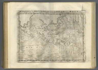
[Ptolemy, Claudius, Gastaldi, Giacomo, Mattioli, Pietro Andrea, 1500-1577, Pedrezano, Giovanbattista]
Full Title
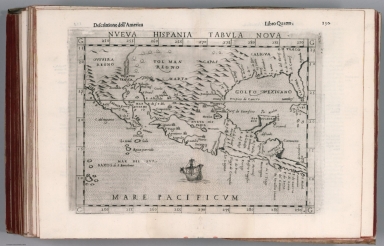
Nueva Hispania tabula nova. (to accompany) Ptolemeo. La geografia di Claudio Ptolemeo alessandrino ... In Venetia, ... per Gioan. Baptista Pedrezano ... Anni x. M.D.XLVIII (1548).
List No
11479.121
Note
Engraved new map of the Southern half of the United States, Mexico and Central America. Shows present-day Mexico, Florida, Texas and one of the earliest depiction of California as a Peninsula on a printed map. In the vicinity of the Colorado River flows the R. Tontonteanc and the Yucatan appears as an island. The place names reflect the explorations of Pineda, Cabeza de Vaca, and Moscosso. Map shows settlements, towns, landmarks, rivers and mountains. Relief shown pictorially.
Author
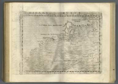
[Ptolemy, Claudius, Gastaldi, Giacomo, Mattioli, Pietro Andrea, 1500-1577, Pedrezano, Giovanbattista]
Full Title
Tierra Nueva. (to accompany) Ptolemeo. La geografia di Claudio Ptolemeo alessandrino ... In Venetia, ... per Gioan. Baptista Pedrezano ... Anni x. M.D.XLVIII (1548).
List No
11479.123
Note
First map of the North American East Coast, and the first map largely devoted to Canada. The map extends from Labrador to Florida. Discoveries reported by Giovanni di Verrazano (1524)and Jacques Cartier's 1st voyage (1534). Several place names used in the map for the first time, are still in use today, including Larcadia (Acadia), Breton (Cape Breton Island), and Labrador. Tierra del Bacalaos, noted by Verrazzano the land of Bacalaia. Tierra de Nurumberg for New England was discovered by Verrazanothe in 1524 voyage, which included ''Larcadia'' (part of North Carolina's coast); Angoulesme (New York Harbor); Flora (south coast of Long Island); and Narragansett Bay. Map shows place names.
Author
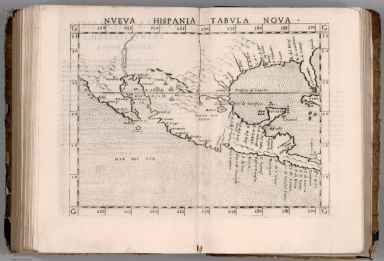
[Ptolemy, Claudius, Ruscelli, Girolamo, Giuseppe Moletti, M.]
Full Title
Nveva Hispania tabvla nova. Nveva Hispania, Trentesimaprima tavola nvova. (To accompany) La geografia di Claudio Tolomeo Alessandrino, nuouamente tradotta di Greco in Italiano, da Girolamo Ruscelli ... In Venetia, Appresso Vincenzo Valgrisi, M.D.LXI. (1561).
List No
11311.125
Note
Engraved map of New Spain. Showing Mexico and Central America, the southern United States, including Florida. California is a peninsula and in the vicinity of the Colorado River flows the R. Tontonteanc, showing Sier Anevada (Sierra Nevada). Relief shown pictorially.
Author
Monte (Monti), Urbano, 1544-1613
Full Title
Tavola XI Che Ha Sua Superiore La Tavola Quarta. Libro Terzo.
List No
10130.013
Author
[Ptolemy, Claudius, Ruscelli,Girolamo, Rosaccio, Giuseppe]
Full Title
Nveva Hispania tabvla nova. Descrittione dell'America. Libro Quarto. (to accompany) Geographia di Clavdio Tolomeo alessandrino, tradotta di Greco nell'idioma volgare Italiano da Girolamo Ruscelli ... In Venetia, MDXCIX (1599) Appresso gli heredi di M. Sessa.
List No
11299.068
Note
Engraved map of New Spain. Showing the southern United States, including Texas and Florida and Mexico and Central America. California is a peninsula and in the vicinity of the Colorado River flows the R. Tontonteanc, with place names, showing Sier Anevada (Sierra Nevada). Relief shown pictorially.
Author
[Mercator, Gerhard, 1512-1594, Hondius, Jodocus, 1563-1612]
Full Title
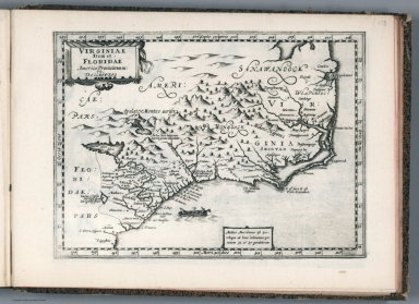
Virginiae Item et Floridae Americae Provinciarum, nova Descriptio.
List No
10501.508
Author
[Wytfliet, Corneille, Magini, Giovanni Antonio]
Full Title
Conibas regio cum vicinis gentibus. (to accompany) Histoire universelle des Indes occidentales et orientales, et de la conversion des Indiens : divisee en trois parties par Cornille Wytfliet & Anthoine Magin & autres historiens. Premiere Partie. A Douay, Chez Francois Fabri, l'An 1611.
List No
11622.054
Note
Uncolored engraved double page map of North America. Shows cities, towns, landmarks, rivers, forests and mountains. Relief shown pictorially. Includes decorative title cartouche. Generally depicts the region of central Canada and central United States.
Author
[Mercator, Gerhard, 1512-1594, Hondius, Jodocus, 1563-1612, Hondius, Hendrik, 1597-1651]
Full Title
Virginiae Item et Floridae Americae Provinciarum, nova Descriptio.
List No
10534.359
Author
[Mercator, Gerhard, 1512-1594, Hondius, Jodocus, 1563-1612, Hondius, Hendrik, 1597-1651]
Full Title
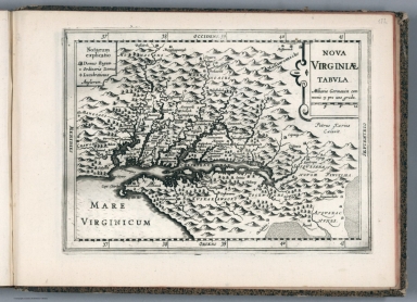
Nova Yirginiae Tabula Amstelodami, ex officina Henrici Hondii.
List No
10621.197
Note
Inset: Status Regis Powhatan quando praefectus Smith Captivus i!Ji daretur (Picture). 10 x 8 cm.
Author
[Blaeu, Joan, 1596-1673, Blaeu, Willem Janszoon, 1571-1638]
Full Title
Curia Hollandiae Exterior
List No
16224.134
Note
Volume One. Dimensions are sheet size. Curia Hollandiae Exterior, translated as the Outer Court of Holland, refers to what is now known as the Binnenhof in The Hague (Den Haag), Netherlands. The Binnenhof is a historic complex of buildings that has served as the center of political power in the Netherlands for centuries. Originally constructed in the 13th century, it was the residence of the Counts of Holland and later evolved into the administrative heart of the Dutch Republic. Curia Exterior: The term likely refers to the external part of the court, including the Ridderzaal (Hall of Knights), which served as a grand hall for gatherings and state functions. Over time, the Binnenhof became the seat of the States General (the Dutch Parliament) and remains the political hub of the Netherlands to this day.
Author
Goos, Pieter, 1616-1675
Full Title
Pas caerte van Nieu Nederlandt en de Engelsche Virginies.
List No
12179.040
Author
[Ogilby, John, 1600-1676, Montanus, Arnoldus, 1625?-1683]
Full Title
Novi Belgii, Quod nune Novi Jorck vocatur, Novae Angliae & Partis Virginiae.
List No
12241.036
Author
[Ogilby, John, 1600-1676, Montanus, Arnoldus, 1625?-1683, Moxon, James]
Full Title
A New Description of Carolina by Order of the Lords Proprietors.
List No
12241.044
Note
North to the right. Foldout.
Author
[Ogilby, John, 1600-1676, Montanus, Arnoldus, 1625?-1683]
Full Title
Virginiae Partis australis, et Floridae partis orientalis, interjacentiumq regionum Nova Descriptio .
List No
12241.045
Note
Inserted in this copy, present in the first issue 1671 but not published in this second issue 1671, replaced by the Lord Proprietors' map.
Author
[Janssonius van Waesberge, Johannes, Mercator, Gerhard, 1512-1594, Cloppenburg, Johannes, 1592-1652]
Full Title
Sclavonia, Croatia, Bosniacum Dalmatiae Parte. (to accompany) Atlas sive Cosmographicae Meditationes de Fabrica mundi et fabricati figura. De novo multis in locis emendatus novisque tabulis auctus. Amsterodami, apud Iohannem Ianssonium van Waesberge. Anno, 1673.
List No
11487.151
Note
Copper engraved map of Slovenia, Croatia, Bosnia, Dalmatia and neighboring regions. Shows towns, villages, landmarks, mountains, forests and rivers. Relief shown pictorially.
Author
[Janssonius van Waesberge, Johannes, Kaerius, Petrus, Mercator, Gerhard, 1512-1594, Cloppenburg, Johannes, 1592-1652]
Full Title
Nova Virginiae tabula. Petrus Kaerius Caelavit. (to accompany) Atlas sive Cosmographicae Meditationes de Fabrica mundi et fabricati figura. De novo multis in locis emendatus novisque tabulis auctus. Amsterodami, apud Iohannem Ianssonium van Waesberge. Anno, 1673.
List No
11487.176
Note
Copper engraved map of Virginia, showing Chesapeake Bay regionand the surrounding environs. Shows towns, villages, landmarks, mountains, Indian Tribes, and rivers. Relief shown pictorially. Includes explanations.
Author
[Janssonius van Waesberge, Johannes, Mercator, Gerhard, 1512-1594, Cloppenburg, Johannes, 1592-1652]
Full Title
Virginiae item et Floridae Americae Provinciarum, nova descriptio. (to accompany) Atlas sive Cosmographicae Meditationes de Fabrica mundi et fabricati figura. De novo multis in locis emendatus novisque tabulis auctus. Amsterodami, apud Iohannem Ianssonium van Waesberge. Anno, 1673.
List No
11487.177
Note
Copper engraved map of the southeastern part of North America, covers Virginia and Florida. Cover the coast from Chesapeake Bay to St. Augustine. Shows towns, villages, mountains, Indian settlement, and rivers. Relief shown pictorially. Includes notes.
Author
Jollain, Gerhard
Full Title
L'Angleterre Novissima Descriptio Angliae Scotiae et Hiberniae
List No
15185.041
Author
Du Val, Pierre, 1619-1683
Full Title
La Floride.
List No
12503.044
Author
[Lea, Philip, Thornton, John, Morden, Robert]
Full Title
A New Map of New England New York New Iarsey Pensilvania Maryland and Virginia
List No
10119.000
Note
"Early and highly important map of the English Colonies in North America, which includes the earliest printed plan of New York Harbor. Thornton, Morden & Lea's map is the first obtainable state of the finest general map of England’s American colonies to date. The map is one of the earliest to include Augustine Herrman’s cartography for Virginia and Maryland. To the North it includes one of the earliest depictions of the Pennsylvania colony (est. 1681), the first printed chart of New York Harbor, and significant additions to the cartography of New England. The map shows the English colonies from Cape Ann in Massachusetts to Cape Henry at the mouth of Chesapeake Bay. The map extends as far north as the tributaries of the Hudson, and in the southwest it shows the Delaware and Susquehannah Rivers and as far west as the tributaries of the Potomac and Rapahannock. Augustyn and Cohen note the importance of the inset:: 'To the ambitious person, the map would have presented an enticing vista: it displays a loose federation of colonies, between and beyond which there appears to be ample unclaimed land. It creates an image of an area comfortingly linked by civilization but still containing much open territory.'The geography of Virginia, Maryland, Pennsylvania and New Jersey derives from the Thornton-Greene Mapp of Virginia Mary-land, New Jarsey, New-York, & New England (ca 1678), whose depiction of the region is in turn based largely on Augustine Herrman’s Virginia and Maryland (1673). The Thornton-Morden-Lea departs from these prototypes, however, in showing the new colony of Pennsylvania and incorporating changes to the course of the Delaware and place names along its banks. New York and southern New England are drawn from the Thornton-Greene map, which in turn draws on John Seller’s Mapp of New England (1676). Here as well, Thornton, Morden and Lea, have departed substantially from the prototypes: Long Island’s barrier beaches are shown for the first time on a printed map and numerous place names are introduced along the Connecticut coast and on Cape Cod; the boundaries between Massachusetts, Plymouth and Connecticut colonies are drawn; and several roads are shown. " (Ruderman)
Author
Nolin, Jean Baptiste, 1648-1708
Full Title
(Covers to) Carte general.
List No
14353.001
Note
Covers to Cartes generales des Royaumes de l'Europe et des particuliers de France. Bound in leather, with spine in seven gilded compartments separated by raised bands; second compartment with red morocco title piece in gilded letters. Title translates to: General maps.
Author
Nolin, Jean Baptiste, 1648-1708
Full Title
(Contents to) Table des cartes comprises en le Receuil.
List No
14353.002
Note
Manuscript list of maps within Cartes generales des Royaumes de l'Europe et des particuliers de France. Map titles listed in ink, with associated plate numbers. Annotations in pencil, including map dates. Title translates to: Table of maps included in the Collection.
Author
Nolin, Jean Baptiste, 1648-1708
Full Title
(Title Page to) Cartes generales des Royaumes de l'Europe et des particuliers de France. A Paris, Chez J. B. Nolin sur le Quay de l’Horloge du Palais Vers le Pont Neuf, a lEnseigne de la Place des Victoires. 1693.
List No
14353.003
Note
Title page to Cartes generales des Royaumes de l'Europe et des particuliers de France. Appears in a combination of printed engraving and manuscript, with print pasted onto sheet and hand-drawn foliage continuing the printed flora. With dedication: Dedié a Louis Le Grand Roy de France et de Navarre. Par son très Humble serviteur, et Fidelle Sujet. Avec Privilege du Roy. Illustration shows a group of figures looking at a map, with a globe in the background. Title translates to: General maps of the Kingdoms of Europe and of France.
Author
[Nolin, Jean Baptiste, 1648-1708, Du Tralage, Jean Nicolas, -1699]
Full Title
Le Globe Terrestre represente en deux plans-hemispheres. Par P. Coronelli Cosmographe, etc. Corrigé et augmenté par le Sr. de Tillemon. A Paris, Chez J. B. Nolin sur le Quay de l’Horloge du Palais proche la Rue de Harlay a l'Enseigne de la Place des Victoires. Avec Privilege du Roy. 1699. A Monseigneur Mgr. Messire Louis de Boucherat Chancellier de France.
List No
14353.004
Note
World map in western and eastern hemispheres, as well as eight globes featuring additional projections, and two celestial wheels. Title translates to: The terrestrial globe is represented in two hemispherical planes. Maps show political boundaries, cities, topography, lakes, drainage, coastlines, shoals and islands. California shown as an island. Relief shown pictorially. Maps include latitudinal and longitudinal lines, and explanatory notes. Black and white engraving with hand-colored borders. Map is 44 x 60 cm, on double sheet 50 x 67 cm. (Plate number handwritten in ink on verso.)
Author
[Nolin, Jean Baptiste, 1648-1708, Coronelli, Vincenzo, 1650-1718, Du Tralage, Jean Nicolas, -1699]
Full Title
L'Europe selon les memoires les plus Nouveaux. Dresseé par le P. Coronelli Cosmographe de la Rep. de Venise Corrigée par le Sr. Tillemon, et dediée a Monseigneur le Marquis de Louvois, et de Courtenvaux, Coner. du Roy en tous ses Conseils, Ministre et Secretaire d'Estat, Commandeur et Chevalier des Ordres de sa Majesté, Surintendant general des Bastimens, Arts, et Manufactures de France. Par son tres humble et obeissant Serviteur J. B. Nolin. A Paris, Chez J. B. Nolin, sur le Quay de l’Horloge du Palais,Vers le Pont Neuf. a l'Enseigne de la Place des Victoires. Avec Privilege du Roy. 1696.
List No
14353.005
Note
Map of Europe. Title translates to: Europe according to the most recent memories, drawn by Coronelli, Cosmographer. Shows political boundaries, cities, topography, vegetation, lakes, drainage, coastlines, shoals and islands. Relief shown pictorially. Includes latitudinal and longitudinal lines, as well as four bar scales and explanatory notes. Decorative cartouche, with figures. Black and white engraving with hand-colored borders. Map is 44 x 59 cm, on double sheet 50 x 67 cm. (Plate number handwritten in ink on verso.)
Author
[Nolin, Jean Baptiste, 1648-1708, Coronelli, Vincenzo, 1650-1718, Du Tralage, Jean Nicolas, -1699]
Full Title
L'Espagne diviseé en plusieurs estats et provinces au Roy Catholique, et au Roy de Portugal. Dresseé par le P. Coronelli Geographe etc. Corrigée et augmentée par le Sr. Tillemon et dediée a Messire Michel le Peletier Cheaulier, Conseiller d'Estat ordinaire et Intendant des Finances par ses tres humbles et Obeissants Serviteurs le P. Coronelli et J. B. Nolin. A Paris, Chez J. B. Nolin, sur le Quay de l’Horloge du Palais,Vers le Pont Neuf a l'Enseigne de la Place des Victoires. Avec Privilege du Roy. 1689.
List No
14353.006
Note
Map of Spain and Portugal. Title translates to: Spain divided into several states and provinces to the Catholic King, and to the King of Portugal. Shows political boundaries, cities, ports, topography, lakes, drainage, coastlines, islands and anchorage. Relief shown pictorially. Includes latitudinal and longitudinal lines, as well as a legend, five bar scales and explanatory notes. Decorative cartouches, with flora and fauna. Black and white engraving with hand-colored borders. Map is 45 x 59 cm, on double sheet 50 x 67 cm. (Plate number handwritten in ink on verso.)
Author
[Nolin, Jean Baptiste, 1648-1708, Du Tralage, Jean Nicolas, -1699]
Full Title
La principauté de Catalogne avec les Comtez de Roussillon et de Cerdagne divisée en Vielle et Nouvelle, et en Vegueries par le Sr. Cantel Geographe, Nouvellement Corrigée et augmenteé sur divers Memoires par le Sieur de Tillemont. dediée a Mgr. le Mal. Duc de Noailles Pair de France, Chevalier des Ordres du Roy, General des Armeés de Sa Majesté en Catalogne, etc. Capitaine de la premiere Compagnie des Gardes du Corps, Gouverneur des Comtez et Vegueries de Roussillon, Conflent, Cerdagne, et pays Adiacents, etc. Par son tres humble Serviteur J. B. Nolin. A Paris, Chez J. B. Nolin, sur le Quay de l’Horloge du Palais,Vers le Pont Neuf a l'Enseigne de la Place des Victoires. Avec Privilege du Roy. 1694.
List No
14353.007
Note
Map of Catalonia, Spain. Title translates to: The principality of Catalonia ... Shows political boundaries, cities, ports, forts, routes, topography, lakes, drainage, coastline and islands. Relief shown pictorially. Includes latitudinal and longitudinal lines, as well as a legend, four bar scales and explanatory notes. Decorative cartouche. Black and white engraving with hand-colored borders. Map is 42 x 56 cm, on double sheet 50 x 67 cm. (Plate number handwritten in ink on verso.)
Author
[Nolin, Jean Baptiste, 1648-1708, Du Tralage, Jean Nicolas, -1699]
Full Title
Le Royaume de France avec ses Aquisitions Suivant le Traité de Paix de Rysvvick 1697. Divisé en Gouvernemens de Provinces et Dedié a Louis le Grand Roy de France et de Navarre par son tres humble serviteur et sujet J. B. Nolin. Geographe de Son Altesse Royale Monsieur. Corrigée et augmenteé par le Sr. Tillemon. A Paris, Chez J. B. Nolin, sur le Quay de l’Horloge du Palais,Vers le Pont Neuf a l'Enseigne de la Place des Victoires. Avec Privilege du Roy. 1698.
List No
14353.008
Note
Map of France. Title translates to: The Kingdom of France with its acquisitions following the Peace Treaty of Rysvvick, 1697. Shows political boundaries, cities, ports, topography, lakes, drainage, coastline and islands. Relief shown pictorially. Includes latitudinal and longitudinal lines, as well as a legend, four bar scales and explanatory notes. Decorative cartouche with eleven inset maps showing city plans: Strasbourg -- Lille -- Cittadelle de Longwi -- Besançon -- Donquerque -- Paris -- Cambray -- Saar Louis -- Le Fort Louis de Rhein -- Cittadelle de Tournay -- Huningue. Black and white engraving with hand-colored borders. Map is 43 x 59 cm, on double sheet 50 x 67 cm. (Plate number handwritten in ink on verso.)
Author
[Nolin, Jean Baptiste, 1648-1708, Du Tralage, Jean Nicolas, -1699]
Full Title
Le Duché et Gouvernement de Normandie divisé en Haute et Basse Normandie, en Divers Pays; et par Evechez, avec le Gouvernement general du Havre de Grace. Dressé sur les Memoires du Sr. de Tillemon et dedié a Monsieur Bignon Conseiller du Roy en ses Conseils, Me. des Reqtes. de son Hostel, Intendant de Justic, Police, et Finance, en la Generalité de Roüen par son tres humble et tres obeissant serviteur J. B. Nolin. A Paris, Chez J. B. Nolin, sur le Quay de l’Horloge a l'Enseigne de la Place des Victoires. Vers le Pont Neuf. Avec Privilege du Roy. 1694.
List No
14353.009
Note
Map of Normandy, France. Title translates to: The Duchy and Government of Normandy divided into Upper and Lower Normandy, into various countries ... Shows political boundaries, cities, ports, topography, vegetation, lakes, drainage, coastline, shoals, islands and anchorage. Relief shown pictorially. Includes latitudinal and longitudinal lines, as well as a legend, four bar scales and explanatory notes. Decorative cartouche with mythical figures. Black and white engraving with hand-colored borders. Map is 44 x 59 cm, on double sheet 50 x 67 cm. (Plate number handwritten in ink on verso.)
Author
[Nolin, Jean Baptiste, 1648-1708, Du Tralage, Jean Nicolas, -1699]
Full Title
La Province de Picardie diviseé en Haute et Basse Picardie, et Subdiviseé en divers Pays. Le Gouvernement genal. de Picardie ou sont les Pays de Boulenois avec le Pays Reconquis, le Ponthieu avec le Vimeux, l'Amienois, le Santerre, le Vermandois, et le Tierrache, en Picardie; avec le Comté d'Artois, et partie de celuy de Haynaut, dans les Pays Bas. La Partie Septentrionale du Gouvernement General de l'Isle de France comprenant les Pays de Beauvaisis, le Noyonois, le Laonois, le Soissonois, et le Valois, dans la Picardie. Dresseé selon les Memoires du St. Tillemon et dediée a Sa Majesté par son tres humble obeissant et tres fidel subiet et Serviteur J. B. Nolin. A Paris, Chez J. B. Nolin, sur le Quay de l’Horloge du Palais a l'Enseigne de la Place des Victoires. Vers le Pont Neuf. Avec Privilege du Roy. 1694.
List No
14353.010
Note
Map of Picardy, France. Title translates to: The Province of Picardy divided into Upper and Lower Picardy, and subdivided into various countries ... Shows political boundaries, cities, ports, topography, vegetation, lakes, drainage, coastline and islands. Relief shown pictorially. Includes latitudinal and longitudinal lines, as well as a legend, three bar scales and explanatory notes. Decorative cartouches with figures and cartographic instruments, including a globe. Black and white engraving with hand-colored borders. Map is 44 x 59 cm, on double sheet 50 x 67 cm. (Plate number handwritten in ink on verso.)
Author
[Nolin, Jean Baptiste, 1648-1708, Du Tralage, Jean Nicolas, -1699]
Full Title
Le Gouvernement general de Champagne presenté à Sa Majesté divise en quatre Lieutenances grles. scavoir les lieutenances gr. les de Reims, Vitry, Troyes, et de la Brye Champenoise. La generalité de Chaalons subdivisée en douse elections qui sont Chaalons, Rethel, Reims, Vitry, Chaumont, Langres, Bar sur Aube, Troyes, Epernay, Sté. Menehoud, Joinville en Champagne, et Sezane en Brye rectifiée suivant l'edit de 1698. La province de Brye divisée en Brye Françoise et Brye champenoise. Partie de la generalité de Paris &c. le tout dressé sir les Memoires du Sr. de Tralage dit de Tillemon par J. B. Nolin Geographe de S. A. R. Monsieur. A Paris, Chez J. B. Nolin, sur le Quay de l’Horloge du Palais a l'Enseigne de la Place des Victoires. Vers le Pont Neuf. Avec Privilege du Roy. 1699.
List No
14353.011
Note
Map of Champagne, France. Title translates to: The General Government of Champagne presented to His Majesty divided into four General Lieutenancies ... Shows political boundaries, cities, topography, vegetation and drainage. Relief shown pictorially. Includes latitudinal and longitudinal lines, as well as a legend, four bar scales and explanatory notes. Decorative cartouche with figures tending crops. Black and white engraving with hand-colored borders. Map is 56 x 48 cm, on double sheet 67 x 50 cm. (Plate number handwritten in ink on verso.)
Author
[Nolin, Jean Baptiste, 1648-1708, Du Tralage, Jean Nicolas, -1699]
Full Title
La Province ou Duché de Bretagne diviseé en deux Grandes Parties, qui sont la Haute, et la Basse Bretagne. Le Gouvernement General de Bretagne, comprenant les lieutenances generales de Bretagne et du Comté Nantois. La Lieutenance Generale de Bretagne est partagée en Lieutenances de Roy de Haute et de Basse Bretagne qui sont subdivisées en plusieurs evechez. Dressée sur divers Memoires Nouveaux de Sr. Tillemon et dediée a son Altesse Royale Monsieur fils de France, free unique du Roy, et Duc d'Orleans. par son tres humble et tres obeissant serviteur Jean B. Nolin. A Paris, Chez J. B. Nolin, sur le Quay de l’Horloge du Palais a l'Enseigne de la Place des Victoires. Vers le Pont Neuf. Avec Privilege du Roy. 1695.
List No
14353.012
Note
Map of Brittany, France. Title translates to: The Province or Duchy of Brittany divided into two great parts, which are Upper and Lower Brittany, the General Government of Brittany, comprising the Lieutenancies General of Brittany and the County of Nantes ... Shows political boundaries, cities, ports, routes, topography, vegetation, lakes, drainage, shoals and islands. Relief shown pictorially. Includes latitudinal and longitudinal lines, as well as a legend, three bar scales and explanatory notes. Decorative cartouche with mythical figures. Black and white engraving with hand-colored borders. Map is 43 x 61 cm, on double sheet 50 x 67 cm. (Plate number handwritten in ink on verso.)
Author
Nolin, Jean Baptiste, 1648-1708
Full Title
Carte de Nivernois.
List No
14353.013
Note
Map of Nivernais, France. Title translates to: Map of Nivernais. Shows political boundaries, cities, topography, vegetation and drainage. Relief shown pictorially. Includes latitudinal and longitudinal lines, as well as a bar scale and compass rose. Decorative cartouche. Black and white engraving with hand-colored borders. Map is 35 x 50 cm, on double sheet 50 x 67 cm. (Plate number handwritten in ink on verso.)
Author
Nolin, Jean Baptiste, 1648-1708
Full Title
Le Gouvernement General et Militaire du Lyonnois comprenant les Provinces du Lyonnais, du Forez, et du Beaujolois. Partie du Gouvernement General de Bourgogne ou sont Le Bailliage de Macon, le Comté de Charolois, et une grande partie de la Bresse, divisée en ses Mandemens. La Principauté et Souveraineté de Dombes, divisée en ses Chatellenies la generalité de Lyon qui Contient les elections de Lyon, de Saint Estgenne, de Montbrison, de Roanne, et de Ville Franche. Dressée selon les Memoires du R. P. Menestrier de la Compagnie de Iesus. et dedié à Mr. le Prevost des Marchands et a Mrs. les Echevins de la Ville de Lyon. Par leur tres humble Serviteur J. B. Nolin. A Paris, Chez J. B. Nolin Geographe de S. A. Royal Monsieur Frere Unique du Roy sur le Quay de l’Horloge du Palais a l'Enseigne de la Place des Victoires avec Privilege du Roy. 1697.
List No
14353.014
Note
Map of Lyon, Forez and Beaujolais, France. Title translates to: The general and military government of Lyonnais, comprising the Provinces of Lyonnais, Forez, and Beaujolais ... Shows political boundaries, cities, routes, topography, vegetation and drainage. Relief shown pictorially. Includes latitudinal and longitudinal lines, as well as a legend, four bar scales and explanatory notes. Decorative cartouche with mythical figures. Black and white engraving with hand-colored borders. Map is 39 x 61 cm, on double sheet 50 x 67 cm. (Plate number handwritten in ink on verso.)
Author
[Nolin, Jean Baptiste, 1648-1708, Beins, Jean de, 1577-1651, Chorier, Nicolas, 1612-1692, Du Tralage, Jean Nicolas, -1699]
Full Title
Le Gouvernement General du Dauphiné divisé en Haut et Bas, subdivisé en plusieurs Pays et en Bailliages selon les Memoires de I. de Beins Geographe du Roy, de N. Chorier, et de plusieurs Autres. par le Sr. Tillemon. A Paris, Chez J. B. Nolin sur le Quay de l’Horloge du Palais proche la Rüe de Harlay a l'Enseigne de la Place des Victoires avec Privilege du Roy. 169.
List No
14353.015
Note
Map of Dauphiné, France. Title translates to: The general government of Dauphiné divided into "Haut and Bas," subdivided into several countries ... according to the memories of I. de Beins, Geographer of the King, N. Chorier, and several others. Shows political boundaries, cities, routes, topography, vegetation and drainage. Relief shown pictorially. Includes latitudinal and longitudinal lines, as well as a legend, three bar scales and explanatory notes. Decorative cartouche. Black and white engraving with hand-colored borders. Map is 45 x 61 cm, on double sheet 50 x 67 cm. (Plate number handwritten in ink on verso.)
Author
[Nolin, Jean Baptiste, 1648-1708, Bouche, Honoré, 1598-1671, Briançon, Robert de, Du Tralage, Jean Nicolas, -1699]
Full Title
Le Comté et Gouvernement de Provence avec les terres adjacentes; divisé en Sene Chaussees, et en Vigueries. Selon les Memoires de Honore Bouche, Robert de Briançon, Petré, et de plusieurs autres autheurs; par le Sr. Tillemon. Dedié et Presenté a Louis le Grand Roy de France et de Navarre par son tres humble tres obeissant et tres fidelle subjet et serviteur J. B. Nolin. A Paris, Chez J. B. Nolin sur le Quay de l’Horloge du Palais a l'Enseigne de la Place des Victoires. Vers le Pont Neuf, avec Privi. du Roy. 1694.
List No
14353.016
Note
Map of Provence, France. Title translates to: The County and Government of Provence with the adjacent lands ... Shows political boundaries, cities, routes, topography, vegetation, lakes, drainage, coastline and islands. Relief shown pictorially. Includes latitudinal and longitudinal lines, as well as a legend, three bar scales and explanatory notes. Decorative cartouche with flags. With inset map: Les Embouchures du Rhosne comme elles etoient en l'Année 1591. Black and white engraving with hand-colored borders. Map is 44 x 62 cm, on double sheet 50 x 67 cm. (Plate number handwritten in ink on verso.)
Author
[Nolin, Jean Baptiste, 1648-1708, Du Tralage, Jean Nicolas, -1699]
Full Title
Le Gouvernement general de Languedoc divisé en trois Lieutenances generales ... Les Gouvernemens Generaux de la Catalogne François, de Foix, et Partie de la Lieutenance Generale de Haute Guiene. Dressez sur les Memoires du Sr. Tillemon, par J. B. Nolin. A Paris, Chez J. B. Nolin sur le Quay de l’Horloge du Palais à l'Enseigne de la Place des Victoires. Vers le Pont Neuf, avec Privi. du Roy.
List No
14353.017
Note
Map of Languedoc, France. Title translates to: The general government of Languedoc divided into three Lieutenancies ... Shows political boundaries, cities, topography, vegetation, lakes, drainage, coastline and islands. Relief shown pictorially. Includes latitudinal and longitudinal lines, as well as a legend, four bar scales and explanatory notes. Decorative cartouche with flags, as well as an additional cartouche containing the dedication. Black and white engraving with hand-colored borders. Map is 44 x 60 cm, on double sheet 50 x 67 cm. (Plate number handwritten in ink on verso.)
Author
[Nolin, Jean Baptiste, 1648-1708, Gautier, Fléchier, Esprit, 1632-1710]
Full Title
Diocese de Nismes. Dressé Nouvellement sur les Lieux par le Sr. Gautier Architecte et Ingenieur de la Province de Languedoc. Dedié a Monseigneur Esprit Flechier Evêque de Nismes par son tres humble et tres obeissant Serviteur J. B. Nolin. 1698. A Paris, Chez J. B. Nolin Geographe de S. A. R. Monsieur Frere Unique du Roy sur le Quay de l’Horloge du Palais à l'Enseigne de la Place des Victoires. Vers le Pont Neuf. Avec Privilege du Roy. Cette Carte a esté faite par l'ordre et par les soins de Mgur. Flechier Eveque de Nismes l'An 1698.
List No
14353.018
Note
Map of Nîmes, France. Title translates to: Diocese of Nismes : Newly drawn up on the premises by Sr. Gautier, Architect and Engineer of the Province of Languedoc. Shows political boundaries, cities, routes, topography, vegetation, lakes, drainage, coastline and islands. Relief shown pictorially. Includes latitudinal and longitudinal lines, as well as a legend, bar scale and explanatory notes. Decorative cartouches with cherbus; as well as an additional cartouche containing the imprint. With one inset map and seven views: Plan de la Ville Nismes -- Elevation perspective de l'Amphiteatre de Nismes -- Façade du Pont du Gard -- Façade de l'Amphiteatre -- Façade de la Maison Quarrée de Nismes : Plan de la Maison Quarrée - Plan du Temple de Diane -- Profils du Temple de Diane : Coupe sur la Largeur -- Coup sur la Longueur. Black and white engraving with hand-colored borders. Map is 45 x 62 cm, on double sheet 50 x 67 cm. (Plate number handwritten in ink on verso.)
Author
Nolin, Jean Baptiste, 1648-1708
Full Title
Les Isles Britanniques ou sont les Royaumes d'Angleterre d'Escosse et d'Irlande &c. divisez en leurs Provinces et Subdivisez en Comtez. Dresses sur les Memoires les plus nouveax. A Paris, Chez J. B. Nolin Geographe de S. A. R. Mr. sur le Quay de l’Horloge du Palais a l'Enseigne de la Place des Victoires. Avec Privilege du Roy. 1698.
List No
14353.019
Note
Map of the British Isles. Title translates to: The British Isles or the Kingdoms of England, Scotland and Ireland divided into their provinces. Shows political boundaries, cities, ports, routes, topography, vegetation, lakes, drainage, coastlines and islands. Relief shown pictorially. Includes latitudinal and longitudinal lines, as well as a legend, three bar scales and explanatory notes. Decorative cartouche with angel. With inset map: Occean Septentrional. Black and white engraving with hand-colored borders. Map is 59 x 49 cm, on double sheet 67 x 50 cm. (Plate number handwritten in ink on verso.)
Author
[Nolin, Jean Baptiste, 1648-1708, Coronelli, Vincenzo (1650-1718), Du Tralage, Jean Nicolas, -1699]
Full Title
Le Royaume d'Angleterre divisé en plusieurs Parties, subdivisées en Comtez ou Shireries ou sont auss y remarquez les Royaumes quil y anoit autrefois. Dressé par le P. Coronelli Cosmographe de la Serme. Rep. de Venise. Corrigée et augmenté par le Sr. Tillemon, et dediée a Jacques II. Roy d'Angleterre, d'Escosse, et d'Irlande par son tres humgle Serviteur J. B. Nolin. A Paris, Chez J. B. Nolin sur le Quay de l’Horloge du Palais, proche la Rue de Harlay, a l'Enseigne de la Place des Victoires. Avec Privilege du Roy. 1689.
List No
14353.020
Note
Map of England. Title translates to: The Kingdom of England divided into several parts, subdivided into Shires ... Shows political boundaries, cities, ports, routes, topography, vegetation, lakes, drainage, coastlines, shoals and islands. Relief shown pictorially. Includes latitudinal and longitudinal lines, as well as a legend, four bar scales and explanatory notes. Decorative cartouche with knights in armor. With inset table and map: Nombre des Comtez dioceses, citez, villes, parroisses, chasteeaux, parcs, forests, rivieres, et ponts, du Royaume d'Angleterre -- Les Isles de Iersey et Garnesey aux Anglois. Black and white engraving with hand-colored borders. Map is 43 x 50 cm, on double sheet 50 x 67 cm. (Plate number handwritten in ink on verso.)
Author
[Nolin, Jean Baptiste, 1648-1708, Coronelli, Vincenzo (1650-1718), Du Tralage, Jean Nicolas, -1699]
Full Title
Le Royaume d'Escosse divisé en deux Parties, subdivisées en Provinces etc. Dressé par le P. Coronelli Cosmographe de la Serme. Rep. de Venise. Corrigée et augmenté par le Sr. Tillemon, et dediée a Monseigneur le Prince de Galles Fils de Jaques Second Roy d'Angleterre, d'Escosse, et d'Irlande. Par son tres humble Serviteur J. B. Nolin. A Paris, Chez J. B. Nolin sur le Quay de l’Horloge du Palais, proche la Rue de Harlay, a l'Enseigne de la Place des Victoires. Avec Privilege du Roy. 1689.
List No
14353.021
Note
Map of Scotland. Title translates to: The Kingdom of Scotland divided into two parts, subdivided into Provinces etc. ... Shows political boundaries, cities, ports, topography, vegetation, lakes, drainage, coastlines, shoals and islands. Relief shown pictorially. Includes latitudinal and longitudinal lines, as well as a legend, three bar scales and explanatory notes. Decorative cartouche. With three inset maps: Les Isles de Ferro ou Farre -- Les Isles de Schetland -- Les Isles d'Orney ou Orcades. Black and white engraving with hand-colored borders. Map is 45 x 60 cm, on double sheet 50 x 67 cm. (Plate number handwritten in ink on verso.)
Author
[Nolin, Jean Baptiste, 1648-1708, Petty, Du Tralage, Jean Nicolas, -1699]
Full Title
Le Royaume d'Irlande divisé en Provinces subdivisées en Comtez et en Baronies selon les Memoires du Sr. Petty et d'Autres. Corrigé et augmenté par le Sr. Tillemon. Dedié a Marie d'Este Reyne d'Angleterre, d'Escosse, et d'Irlande. Par son tres humble Serviteur J. B. Nolin. A Paris, Chez J. B. Nolin sur le Quay de l’Horloge du Palais, proche la Rue de Harlay, a l'Enseigne de la Place des Victoires. Avec Privilege du Roy. 1695.
List No
14353.022
Note
Map of Ireland. Title translates to: The Kingdom of Ireland divided into provinces subdivided into counties and baronies according to the memoirs of Sr. Petty and others. Shows political boundaries, cities, ports, topography, vegetation, lakes, drainage, coastlines, shoals and islands. Relief shown pictorially. Includes latitudinal and longitudinal lines, as well as a legend, seven bar scales and explanatory notes. Decorative cartouche with mythical figures. Black and white engraving with hand-colored borders. Map is 59 x 45 cm, on double sheet 67 x 50 cm. (Plate number handwritten in ink on verso.)
Author
[Nolin, Jean Baptiste, 1648-1708, Coronelli, Vincenzo (1650-1718), Du Tralage, Jean Nicolas, -1699]
Full Title
La partie Meridionale des Pays Bas, Connuë sous le nom Flandre divisée en plusieurs Provinces qui sont possedees par les Roys de France et d'Espagne et par les Estats Generaux des Provinces Unies ou Hollandois par le P. Coronelli. Corigeé augmenteé par le Sr. Tillemont. Dedié a son Altesse Royale Monseigneur le Duc Dorleans Frere Unique du Roy. Par son tres humble Serviteur J. B. Nolin. A Paris, Chez J. B. Nolin sur le Quay de l’Horloge du Palais, proche le Pont Neuf, a l'Enseigne de la Place des Victoires. Avec Privilege du Roy. 1690.
List No
14353.023
Note
Map of Flanders, Belgium. Title translates to: The southern part of the Netherlands, known as Flanders divided into several provinces which are owned by the Kings of France and Spain ... Shows political boundaries, cities, ports, routes, topography, vegetation, lakes, drainage, coastline and islands. Relief shown pictorially. Includes latitudinal and longitudinal lines, as well as a legend, three bar scales and explanatory notes. Decorative cartouche. Black and white engraving with hand-colored borders. Map is 43 x 59 cm, on double sheet 50 x 67 cm. (Plate number handwritten in ink on verso.)
Author
[Nolin, Jean Baptiste, 1648-1708, Sanderus, Antoine, 1586-1664, Du Tralage, Jean Nicolas, -1699]
Full Title
Le Comté de Flandre divisé en ses Parties, Quartiers, et Juridictions. Selon les Memoires de Sanderus et de plusieurs autres auteurs. Par le Sr. Tillemon. A Paris, Chez J. B. Nolin sur le Quay de l’Horloge du Palais, Proche la Rüe de Harlay, a l'Enseigne de la Place des Victoires. Avec Privilege du Roy. 1692.
List No
14353.024
Note
Map of Flanders, Belgium. Title translates to: The County of Flanders divided into its parts, districts, and jurisdictions, according to the memoirs of Sanderus and several other authors. Shows political boundaries, cities, ports, routes, topography, vegetation, lakes drainage, coastline and islands. Relief shown pictorially. Includes latitudinal and longitudinal lines, as well as two bar scales and explanatory notes. Decorative cartouche. Black and white engraving with hand-colored borders. Map is 42 x 55 cm, on double sheet 50 x 67 cm. (Plate number handwritten in ink on verso.)
Author
[Nolin, Jean Baptiste, 1648-1708, Guicciardini, Lodovico, 1521-1589, Penez, Du Tralage, Jean Nicolas, -1699]
Full Title
Le Comté de Haynaut divisé et plusieurs Pays etc. Le Comté de Camresis, ou la Seigneurie Temporelle de l'Archeveché de Cambray Recueillis des Memoires de Guichardin, de Penez, et d'autres auteurs, par le Sr. Tillemon. Dressez et dediez a son altesse Royalle Monseigneur le duc de Chartres. Par son tres humble serviteur J. B. Nolin Geographe de S. A. R. Monsieur Frere Unique du Roy. A Paris, Chez J. B. Nolin sur le Quay de l’Horloge du Palais a l'Enseigne de la Place des Victoires. Avec Privilege du Roy. 1696.
List No
14353.025
Note
Map of Hainaut, Belgium. Title translates to: The County of Haynaut divided ... collected from the memoirs of Guichardin, Penez, and other authors. Shows political boundaries, cities, routes, topography, vegetation, lakes and drainage. Relief shown pictorially. Includes latitudinal and longitudinal lines, as well as a legend, three bar scales and explanatory notes. Decorative cartouche with mythical figures and cherubs. Black and white engraving with hand-colored borders. Map is 45 x 56 cm, on double sheet 50 x 67 cm. (Plate number handwritten in ink on verso.)
Author
[Nolin, Jean Baptiste, 1648-1708, Du Tralage, Jean Nicolas, -169]
Full Title
Le Comté de Namur avec les Pays d'entre sambre et meuse du condroz et de hasbaie etc. Recueillis sur des Memoires tres particuliers du Sr. Tillemon. Dressez et dediez a son altesse Royalle Monseigneur fils de France, Frere Unique du Roy, et Duc d'Orleans par son tres humble et tres obeissant serviteúr et Geographe J. B. Nolin. A Paris, Chez J. B. Nolin Geographe de S. A. R. Monsieur sur le Quay de l’Horloge du Palais a l'Enseigne de la Place des Victoires. Avec Privilege du Roy. 1696.
List No
14353.026
Note
Map of Namur, Belgium. Title translates to: The County of Namur ... collected from very particular memories of Sr. Tillemon. Shows political boundaries, cities, routes, topography, vegetation, lakes and drainage. Relief shown pictorially. Includes latitudinal and longitudinal lines, as well as a legend, three bar scales and explanatory notes. Decorative cartouche with cherubs. Black and white engraving with hand-colored borders. Map is 43 x 59 cm, on double sheet 50 x 67 cm. (Plate number handwritten in ink on verso.)
Author
[Nolin, Jean Baptiste, 1648-1708, Coronelli, Vincenzo (1650-1718), Du Tralage, Jean Nicolas, -169]
Full Title
Les Provinces Unies ou la Partie Septentrionale des Pays Bas Connüe sous le nom de Hollande. Par le P. Coronelli Geographe etc. Corrigées et augmentées par le Sr. Tillemon. A Paris, Chez J. B. Nolin sur le Quay de l’Horloge du Palais. Vers le Pont Neuf à l'Enseigne de la Place des Victoires. Avec Privilege du Roy. 1690. H. van Loon sculp.
List No
14353.027
Note
Map of the Netherlands. Title translates to: The United Provinces or the Northern Part of the Netherlands known as Holland. Shows political boundaries, cities, routes, topography, vegetation, lakes, drainage, shoals and coastline. Relief shown pictorially. Includes latitudinal and longitudinal lines, as well as a legend, compass rose, four bar scales and explanatory notes. Decorative cartouche with mythical figures. With inset map: [Limbourg]. Black and white engraving with hand-colored borders. Map is 44 x 59 cm, on double sheet 50 x 67 cm. (Plate number handwritten in ink on verso.)
Author
[Nolin, Jean Baptiste, 1648-1708, Du Tralage, Jean Nicolas, -169]
Full Title
L'Allemagne divisée en Haute et Basse, et par Cercles; subdivisée en Etats Ecclesiastiques, Laïques, et Villes Imperiales. Par Jules Reichelt Professeur des Mathematiques a Strasbourg etc. Nouvellement corrigée et augmentée sur divers Memoires par le Sr. Tillemon. Dediée a son Altesse Royale Monseigneur le Duc de Chartres. Par son tres humble Serviteur J. B. Nolin. A Paris, Chez J. B. Nolin sur le Quay de l’Horloge du Palais. Vers le Pont Neuf a l'Enseigne de la Place des Victoires. Avec Privilege du Roy. 1691.
List No
14353.028
Note
Map of Germany. Title translates to: Germany divided into Upper and Lower, and by circles; subdivided into ecclesiastical, secular States, and imperial cities. Shows political boundaries, cities, topography, vegetation, lakes, drainage, shoals and coastline. Relief shown pictorially. Includes latitudinal and longitudinal lines, as well as a legend, three bar scales and explanatory notes. Decorative cartouche with an eagle. Black and white engraving with hand-colored borders. Map is 45 x 59 cm, on double sheet 50 x 67 cm. (Plate number handwritten in ink on verso.)
Author
[Nolin, Jean Baptiste, 1648-1708, Cantel]
Full Title
La Partie Occidentale de l'Allemagne avec les Pays Adjacents le Long du Rhein et des Rivieres quy s'y rendent. Tirée des Memoires de Cantel et de plusrs. autres. Corrigée et augm. par M. le Prieur du Neufmarche. Dediée a Monsieur de Harlay, Seigneur de Bonnevil, Conseiller Ordinaire du Roy en ses Conseils d'Estat, et Privé. Par son tres humble, et Obeissant Serviteur J. B. Nolin. A Paris, Chez J. B. Nolin sur le Quay de l’Horloge du Palais proche la Ryue de Harlay a l'Enseigne de la Place des Victoires. Avec Privilege du Roy. 1690.
List No
14353.029
Note
Map of western Germany. Title translates to: The western part of Germany with the adjacent countries along the Rhine and rivers that go there, taken from the memoirs of Cantel and others. Shows political boundaries, cities, routes, topography, vegetation, lakes, drainage and coastline. Relief shown pictorially. Includes latitudinal and longitudinal lines, as well as a legend, three bar scales and explanatory notes. Decorative cartouche with sword-fighting men on horseback. Black and white engraving with hand-colored borders. Map is 40 x 63 cm, on double sheet 50 x 67 cm. (Plate number handwritten in ink on verso.)
Author
Nolin, Jean Baptiste, 1648-1708
Full Title
La Partie Occidentale de la Haute Allemagne vers le Rhin avec les pais adiacents.
List No
14353.030
Note
Map of western Germany. Title translates to: The western part of Upper Germany towards the Rhine, with the adjacent countries. Shows political boundaries, cities, railways, topography, vegetation, lakes and drainage. Relief shown pictorially. Includes latitudinal and longitudinal lines, as well as legends and explanatory notes. With inset bird's-eye view: Les environs des sources du Rhin. Black and white engraving with hand-colored borders. Map is 41 x 63 cm, on double sheet 50 x 67 cm. (Plate number handwritten in ink on verso.)
|