|
Author
[Buache, Philippe, 1700-1773, L'Isle, Guillaume de, 1675-1726]
Full Title
Carte des lieux ou les differentes longueurs du pendule a secondes ont ete observees. Comprenant toutes les observ(ati)ons qui en ont ete faites par divers astronomes de l'Academie Rle. des Sciences, de la Societe Rle. de Londres &c. Depuis 1670 jusques et compris celles qui ont ete faites en 1735, 1736 et 1737 a Paris, en Amerique, et en Laponie. Par ordre du Roy, et de l'Acad. Rle. des Sci., pour determiner la figure de la Terre. Avec les tables calculees d'apres ces observations par MM Newton, Bradley et de Maupertuis. Dressee par Philippe Buache de l'Ac. des Sci. Gendre deseu Mr. Delisle, P(remi)er Geog. du Roy et de la meme Academie, 1740. A Paris, sur le Quay de la Megisserie au St. Esprit pres le Pont Neuf. Sous le privilege de l'Academie Rle. des Sciences le 6. fevrier 1740.
List No
5698.013
Note
Hand col. world map. Includes tables: Observations de la longueur du pendule par ordre des latitudes du nord au sud -- Tables de l'augmentation de la pesanteur de l'Equateur vers le poles. "Pour la Note des Transact. Philos A., 1734, page 135. Hand col. "55." David Rumsey Collection has "44" added in pencil.
Author
[Colles, Christopher, Ristow, W. editor]
Full Title
Index to the Plates in Christopher Colles' Survey of the Roads of the United States of America. (using the) Map of the Middle States Exhibiting the Post Roads c. 1790 after Evans, Bowles and Bradley.
List No
2467.067
Note
Map is from a 1961 reproduction of Colles' survey. The book is entitled, "A Survey of the Roads of the United States of America, 1789, by Christopher Colles." It reproduces all of the maps (83 in total) as well as two indexes to the maps, a biography of Colles and a bibliography his writings, and an inventory of the extant copies of the Survey.
Author
Wilkinson, Robert
Full Title
North America, published the 12th of August 1804. By R. Wilkinson, No.58, Cornhill, London. E. Bourne Sculp.
List No
5156.000
Note
First edition. Full color. This beautiful, rare map is the first to show the entire Louisiana Territory as part of the United States, both in the delineated boundaries on the map and in the table showing the possessions of the United States: "Province, Ceded by France 30 Apr. 1803, Louisiana." The Bradley "Map of The United States..." of June 2nd, 1804, is the first map to mention the event: ôThe French call the country West of Conecuh River Louisiana & have ceded it to the United States," but the Bradley map shows only a small portion of Louisiana Territory just west of the Mississippi River. Wilkinson follows Arrowsmith's geography (from his "New Discoveries..." map of 1802) in the Rocky Mountain and the Oregon River areas, but adds new settlements and place names not on Arrowsmith's map along the northwest coast. Franklinia is shown between Tennessee and North Carolina. Wheat trashes the 1824 issue (which is unchanged from the 1804) as hopelessly out of date, but this 1804 issue was not seen by Wheat and is very accurate and forward looking for its period. The large folio General Atlas that this map appeared in is elusive: it is not listed in any references (Phillips lists only Wilkinson's smaller General Atlas issues, even though he refers to one or two issues as folio in size). Wilkinson mentions publishing it in parts, with eleven maps completed by 1808 and thirty five completed by 1823 (noted on the index pages of his quarto General and Classical Atlases of those dates). It seems to be as scarce as this North America map.
Author
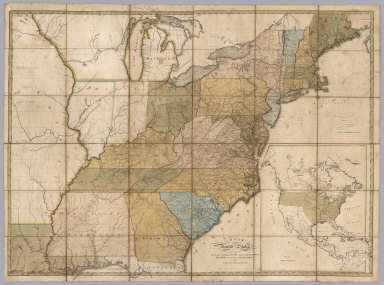
Bradley, Abraham Junior
Full Title
(Covers to) Map of the United States, Exhibiting the Post-Roads, the situations, connexions and distances of the Post-Offices, Stage Roads, Counties & Principal Rivers By Abraham Bradley Junr. Entered ... 2nd day of June1804, by Abraham Bradley Junr. of the District of Columbia. (inset) Map Of North America. (1805)
List No
5812.001
Note
2nd edition or state of this map, with printed date of 1804 but with estimated date of 1805 based on the naming of Michigan Territory which was formed in 1805 The 1804 first edition (see LOC copy) does not name Michigan. Other changes from the first edition include new public surveys on the Indiana Territory and Ohio border and the addition of a Rapids between Jallot Lake and Great Falls on the Red River. Also of note is the coloring of the Lousiana Territory green all the way to the Pacific coast on the inset map of North America. Other copies we have seen show the Lousiana Territory extending only to the Rocky Mountains - the 1809 and the 1812 editions have a dotted line marking the boundary roughly at the Rocky Mountains. This 1805 edition and the 1804 edition do not have such a line north of the the 42nd parallel.
Author
Bradley, Abraham Junior
Full Title
Map of the United States, Exhibiting the Post-Roads, the situations, connexions and distances of the Post-Offices, Stage Roads, Counties & Principal Rivers By Abraham Bradley Junr. Entered ... 2nd day of June1804, by Abraham Bradley Junr. of the District of Columbia. (inset) Map Of North America. (1805)
List No
5812.002
Note
2nd edition or state of this map, with printed date of 1804 but with estimated date of 1805 based on the naming of Michigan Territory which was formed in 1805 The 1804 first edition (see LOC copy) does not name Michigan. Other changes from the first edition include new public surveys on the Indiana Territory and Ohio border and the addition of a Rapids between Jallot Lake and Great Falls on the Red River. Also of note is the coloring of the Lousiana Territory green all the way to the Pacific coast on the inset map of North America. Other copies we have seen show the Lousiana Territory extending only to the Rocky Mountains - the 1809 and the 1812 editions have a dotted line marking the boundary roughly at the Rocky Mountains. This 1805 edition and the 1804 edition do not have such a line north of the the 42nd parallel.
Author
Carleton, Osgood
Full Title
A New Map of the United States, of America Including part of Louisiana. Drawn from the latest Authorities. Revised and corrected by Osgood Carleton Esq. Teacher of Mathematics, Boston. Boston, Published and Sold by John Sullivan, Junr. 1806.
List No
5801.000
Note
Osgood Carleton first published a map of the United States in 1791. Another edition appeared in 1797, and then this edition in 1806. This issue is a major redrawing of the 1791 and 1797 maps, and it borrows heavily from Arrowsmith's Map of the United States, 1802 (see our list no. 5699.009, from Thompson's Alcedo Atlas, our 5699.000) especially in the west. But Carleton uses other sources as well, including Bradley's postal map. There was another issue of this map, undated, and updated to some unknown period, perhaps after 1810 or even later (Chris Lane, Philadelphia Print Shop).
Author
Maclure, William
Full Title
(Title Page to) Observations on the Geology of the United States, explanatory of a Geological Map. By William Maclure. Read January 20th, 1809. (In) Transactions of the American Philosophical Society, Held at Philadelphia, for promoting Useful Knowledge. Volume VI. Published by C. and A. Conrad and Co. Philadelphia. ... Jane Aitken, Printer. 1809.
List No
2749A
Note
1st edition of the first geological map of U.S. A portion of a map of the U.S. by Samuel Lewis is used to make this map. The full sheet of paper was put on a larger plate and pulled, leaving the upper and right side without borders, as issued. Uncut and untrimmed, the map appears here with Maclure's original essay on the geology of the U.S. In 1817 Maclure published an expanded versus of his essay, using the small Melish Map of the U.S. as a base. Maclure was dissatisfied with the Lewis map because of its rendering of the mountains, and an errata slip is attached to the back of p 423 explaining this (and stating that originally it was intended to use a reduction of the Bradley U.S. map). See Marcou 1858 for more discussion of the Lewis map. Maclure did a Paris printing of the article and Map (using a map by Volney as a base) in 1811, in French. The Lewis map is most likely the Map of the U.S. published in the 2nd edition of Carey's American Atlas, 1809 (P-Maps p 876,Walsh). Maclure's map and essay are very rare. There is an inscription on the title page to "Mons. F.A. Michaux-Paris, from his friend..." Map bound into the back of paper covered boards with the title handwritten on the spine. Map in full color by geologic structure.
Author
Maclure, William
Full Title
(Text Page to) Observations on the Geology of the United States, explanatory of a Geological Map. By William Maclure. Read January 20th, 1809. (In) Transactions of the American Philosophical Society, Held at Philadelphia, for promoting Useful Knowledge. Volume VI. Published by C. and A. Conrad and Co. Philadelphia. ... Jane Aitken, Printer. 1809.
List No
2749B
Author
Maclure, William
Full Title
A Map of the United States of America. By Samuel G. Lewis.
List No
2749.001
Author
Bradley, Abraham Junior
Full Title
Map of the United States, Exhibiting the Post-Roads, the situations, connexions and distances of the Post-Offices, Stage Roads, Counties & Principal Rivers By Abraham Bradley Junr. Entered ... 2nd day of June1804, by Abraham Bradley Junr. of the District of Columbia. (inset) Map Of North America. (1809)
List No
3043.000
Note
Third edition. Compared to the first edition of 1804 and the second of 1805, Illinois is added; about 25 towns are added to the western Connecticut Reserve (the Fire Lands) in northern Ohio; Township and Range lines are added in southern Indiana. Relief shown pictorially. Shows Indian tribes. Prime meridian: Washington. Without the case, dissected as issued, mounted on new linen.
Author
Pike, Zebulon Montgomery
Full Title
A Chart of the Internal Part of Louisiana, Including all the hitherto unexplored Countries, lying between the River La Platte of the Missouri on the N: and the Red River on the S: the Mississippi East and the Mountains of Mexico West; with a Part of New Mexico & the Province of Texas by Z.M. Pike Captn. U.S.I.
List No
0730.003
Note
A detailed uncolored map showing the route of the American Exploring Party as well as the route "pursued by the Spaniards going out." Spanish and Indian villages, Spanish and American camps shown as well. The northeast corner of the map includes "Highest Peak" eventually to be known as "Pike's Peak."
Author
Bradley, Abraham Junior
Full Title
(Covers to)Map of the United States, Exhibiting the Post-Roads, the situations, connexions and distances of the Post-Offices, Stage Roads, Counties & Principal Rivers By Abraham Bradley Junr. Entered ... 2nd day of June1804, by Abraham Bradley Junr. of the District of Columbia. (inset) Map Of North America.
List No
2929A
Author
Bradley, Abraham Junior
Full Title
Map of the United States, Exhibiting the Post-Roads, the situations, connexions and distances of the Post-Offices, Stage Roads, Counties & Principal Rivers By Abraham Bradley Junr. Entered ... 2nd day of June1804, by Abraham Bradley Junr. of the District of Columbia. (inset) Map Of North America. (1812)
List No
2929.001
Note
4th edition, corrected to 1812, but dated 1804. This map was originally issued in 1804. This copy is dated 1804 but is corrected for political and topographical changes to 1812. It shows Louisiana and Missouri Territory, both of which were established in 1812. There has been extensive redrawing of the Mississippi River from the junction of the Ohio north to the Wyaconda River (probably due to the public surveys in southern Illinois, evidenced by the appearance of Township and Range lines there). Numerous other changes from the 1804 edition have been made throughout the map adding new counties, towns, roads, and changed physical features, primarily in the mid and western portions. So far I have been able to identify 1804, 1806, 1809, and 1812 editions, but it is likely that other editions will be discovered. The dates are estimates based on the political changes on the maps - all editions are dated 1804 on the title. Since it was a postal map and needed to be current as to towns, road and counties, it is probable that the map was updated every few years, until a new plate was made in 1819 by Harrison (Karpinski 59, Karrow 1-1466). The 1796 edition of this map (a different engraving) was changed four times in as many years (Wheat & Brun 127-130). The 1819 edition became the official post office map in 1825, used until 1829 (Ristow). All of the 1804 to 1812 editions were originally engraved by Francis Shallus of Philadelphia. With outline color. This copy in original condition, dissected into 32 sections and mounted on linen, in original quarter leather marbled covers 27x20 with ties (remnants now) and title "Bradley's U. States" stamped in gild on the spine.
Author
[Kensett, T., Shelton, W.]
Full Title
A Map of the United States and British Provinces of Upper and Lower Canada with other parts adjacent By Shelton & Kensett ... (above the title) To The President The Senators and Representatives of the United States This Map Of The United States Of America Is most Respectfully Dedicated by Shelton & Kensett 1816. Entered According ... October 1st, 1816 ... Connecticut. Projected by Thomas Kensett. A. Doolittle Sc.
List No
4378.000
Note
Large map of the United States based on the Arrowsmith/Tardieu maps of the same period, with a similar "Falls of Niagara" cartouche. Engraved by Amos Doolittle. Interestingly, credit for the cartouche is given to Tardieu, who copied it from Arrowsmith (perhaps evidence of a prejudice against the British from the War of 1812?). This map is far superior to either the Arrowsmith or Tardieu maps: in the west it incorporates both of Pike's maps of the Upper Mississippi and the western tributaries of the Mississippi and the Missouri; east of the Mississippi, it uses much from the Bradley "Postal" map of the United States of 1804/1812, including public survey lines, county formations, township boundaries, roads, etc. There are two very interesting inset maps and a commentary on ancient fortifications along the Ohio River. This highly detailed and accurate map must be one of the best of its period. Outline color by states. Maps is dissected into 35 sections and folds into marbled paper end sheet, then into a new gray cloth folding case 28x23 with "United States Shelton And Kensett 1816" stamped in gilt on the spine.
Author
Lewis, Samuel
Full Title
A New and Correct Map of the United States of North America; Exhibiting the Counties, Towns, Roads &c. in Each State. Carefully Compiled from Surveys and the Most Authentic Documents, by Samuel Lewis. W. & S. Harrison, sculpt. Philadelphia, Published by Kimber & Sharpless for Emmor Kimber 1818.
List No
4439.000
Note
This is the second, unrecorded edition. The first complete edition was 1816, and the third edition, 1819. Ristow notes an incomplete issue (only the title sheet) of 1815. The 1818 and 1819 editions add an inset map of east Florida. This 1818 edition has a printed notation on the U.S. Mexican boundary: "Boundary between the U. States and the Spanish Provinces agreeable to the Treaty of 1819." This indicates that the map was published late in 1818 or early in 1819, either in anticipation of the February, 1819 signing of the treaty, or just after it. This is a huge map, almost six feet square, full of detail on roads, large and small towns, and areas that were "settling up." Like other large U.S. maps (other than the Melish) of the period (Shelton & Kensett, Varle, Bradley, Arrowsmith, Tardieu), this map extends west to just beyond the Mississippi River. It ranks as the largest in size and scale and is certainly the most detailed. And it is rare, with this 1818 copy being perhaps unique. It must have drawn much of its road information from the Bradley postal map of 1804/12. It is similar to the Arrowsmith 1819 in the northwestern areas, but closer to the Tardieu 1818 in the Michigan Peninsula area. It is not clear to us whether Lewis borrowed from Arrowsmith and Tardieu or vice versa, probably it worked both ways. For an enthusiastic contemporary evaluation of the first edition, see our 1815 copy of the advertisement for this map ("It is, we believe, much the largest specimen of geographical design ever produced in the United States...we do not think it equaled by any large map of European workmanship we have ever examined"). Lewis also made a smaller wall map of the U.S. titled "Traveler's Guide: A New and Correct Map of the United States..." in 1819, and another smaller still in 1817 titled "A Correct Map of the United States with the West Indies..." (see our copies).
Author
Arrowsmith, Aaron
Full Title
(C0vers to) A Map Of The United States of North America Drawn from a number of Critical Researches By A. Arrowsmith, Hydrographer to His Majesty. No. 10 Soho Square. Additions to 1819. London. Published as the Act Directs by A. Arrowsmith, No. 10 Soho Square. Jan 1st, 1796. Additions to 1802 ... (inset map of Florida).
List No
3445A
Note
The last edition, with the "wings" on the Mississippi and the Northwest. Adds Illinois, Indiana, Ohio, Michigan, Louisiana, Mississippi and Missouri Territory. Many changes to the topography as well. An inset of the Florida Peninsula appears. The northern wing shows the Lake of the Woods and the southern wing shows the mouths of the Mississippi in detail. The delineation of the roads indicates that Bradley's Postal Map of the U.S. may have been used as a source. Outline color by state. Map is in four sheets, each dissected into 12 sections. Sheets fold into a new slip case 26x18 with the original tan covers pasted down with a label reading "J. Le Nesuvier (645) United States" in manuscript.
Author
Arrowsmith, Aaron
Full Title
A Map Of The United States of North America Drawn from a number of Critical Researches By A. Arrowsmith, Hydrographer to His Majesty. No. 10 Soho Square. Additions to 1819. London. Published as the Act Directs by A. Arrowsmith, No. 10 Soho Square. Jan 1st, 1796. Additions to 1802 ... (inset map of Florida).
List No
3445.001
Note
The last edition, with the "wings" on the Mississippi and the Northwest. Adds Illinois, Indiana, Ohio, Michigan, Louisiana, Mississippi and Missouri Territory. Many changes to the topography as well. An inset of the Florida Peninsula appears. The northern wing shows the Lake of the Woods and the southern wing shows the mouths of the Mississippi in detail. The delineation of the roads indicates that Bradley's Postal Map of the U.S. may have been used as a source. Outline color by state. Map is in four sheets, each dissected into 12 sections. Sheets fold into a new slip case 26x18 with the original tan covers pasted down with a label reading "J. Le Nesuvier (645) United States" in manuscript.
Author
Buckingham, David W.
Full Title
Map OF THE CITY OF NEW HAVEN, FROM ACTUAL SURVEY, by D. W. Buckingham, COUNTY SURVEYOR
List No
15785.000
Author
Loring, Josiah
Full Title
Loring's Celestial Globe Containing all the known Stars, Nebulae &c. Compiled from the Works of Wollaston, Flamsted, De la Caille, Havelius, Mayer, Bradley, Herschel, Maskelyne. The Transactions of the Astronomical Society of London &c. &c. (From Smith's New English Globe.) Boston, Josiah Loring, 136 Washington St. 1833. Annin & Smith sc.
List No
2897.000
Note
2nd issue - this was 1st issued in 1832. Engraved by Annin & Smith. Loring's address is 136 Washington Street, Boston. Shows stars of magnitudes 1 to 9 and nebulae. Accompanies the 1833 Terrestrial 12" globe. Four legged table model with horizon ring. Total height from base to top is 17.5 inches, with the globe measuring 12 inches.
Author
Society for the Diffusion of Useful Knowledge (Great Britain)
Full Title
Munich. Muenchen. Published under the superintendence of the Society for the Diffusion of Useful Knowledge. (Drawn by) W.B. Clarke, arch. Engd. by T. Bradley. Published by Baldwin & Cradock, 47 Paternoster Row, Decr. 1st. 1832. (London: Chapman & Hall, 1844)
List No
0890.190
Note
Engraved map. Hand col. Inset: View of Munich from the East.
Author
[Arnald, George, Society for the Diffusion of Useful Knowledge (Great Britain)]
Full Title
Naples. Napoli. Published under the superintendance of the Society for the Diffusion of Useful Knowledge. (Drawn by) W.B. Clarke, arch: dir: T. Bradley sc. Published by Baldwin & Cradock, March 1835. (London: Chapman & Hall, 1844)
List No
0890.191
Note
Engraved map. Relief shown by hachures. Hand col. Inset views: Castello nuovo , Castello St. Elmo -- Naples from the hill of Posilipo, from a painting by G. Arnald, Esq. A.R.A.
Author
[Joslin, Gilman, Loring, Josiah]
Full Title
Loring's Celestial Globe Containing all the known Stars Nebulae &c. Compiled from the works of Wollaston, Flamsted, de la Caille, Havelius, Mayer, Bradley, Herschel, Maskelyne. The Transactions of the Astronomical Society of London &c, &c. (From Smith's New English Globe). Boston: Josiah Loring, 136 Washington St. 1854.
List No
4661.000
Note
This is a 12-inch floor stand globe paired with the 1854 Terrestrial floor globe by Loring/Joslin. Although Joslin is not listed as publisher on the Celestial globe, I assume he issued it under Loring's imprint. Total height is 41 inches.
Author
U.S. Coast Survey
Full Title
U.S. Coast Survey A.D. Bache Supdt. Reconnaissance of False Dungeness Harbor, Washington. By the Hydrographic Party under the command of Lieut. James Alden U.S.N. Asst. 1853. No. 53. Redd. Drng. by J.R. Key. Engd. by W. Smith & App. J.S. Pettit. (with) U.S. Coast Survey A.D. Bache Supdt. Reconnaissance of New Dungeness Harbor, Washington. Topography by J.S. Lawson Sub-Assist. Hydrography by the party under the command of Lieut. Comdg. J. Alden U.S.N. Assistant. 1856. Redd. Drng. by W.P. Schultz. Engd. by S.W. Bradly & App. W.A. Thompson.
List No
3593.000
Note
1st edition, engraved and printed without color on thin paper, unfolded separate issue. Both charts printed together on one sheet, the same as in the Annual Report for 1856. Relief shown by hachures; depths shown by isolines and soundings. Soundings in feet. Each map includes notes. "No. 53" on upper left margin.
Author
U.S. Coast Survey
Full Title
U.S. Coast Survey A.D. Bache Supdt. Reconnaissance of Olympia Harbor, Washington Ter. By the Hydrographic Party under the command of Lieut. Comdg. J. Alden U.S.N. Asst. 1856. No. 56. Redd. Drng. by F. Fairfax. Engd. by S.W. Bradley & App. F.W. Benner.
List No
3595.000
Note
1st edition, engraved and printed without color on thin paper, unfolded separate issue. Relief shown by hachures. Depths shown by soundings. Includes notes and tables. "No. 56" on upper left margin.
Author
[James, Henry, 1803-1877, Clarke, Alexander Ross, 1828-1914]
Full Title
Ordnance Survey: Base apparatus. Plate II. Drawn and engraved in outline by J. Bradley. Finished by J.C. Peake at the Ordnance Survey Map Office, Southampton, March 1847. (to accompany) (V. 2: plates) Ordnance Trigonometrical Survey. Account of Principal Triangulation. Plates. (with) (V.1: text) Ordnance trigonometrical survey of Great Britain and Ireland : Account of the observations and calculations of the principal triangulation ... London: Printed by George Edward Eyre, and William Spottiswoode. Printers to the Queens most excellent Majesty. 1858.
List No
6877.024
Note
Uncolored diagrams with a profile (Fig.4)
Author
[James, Henry, 1803-1877, Clarke, Alexander Ross, 1828-1914]
Full Title
Ordnance Survey: Base apparatus. Plate III. Drawn and engraved by J.C. Peake at the Ordnance Survey Map Office, Southampton, March 1847. (to accompany) (V. 2: plates) Ordnance Trigonometrical Survey. Account of Principal Triangulation. Plates. (with) (V.1: text) Ordnance trigonometrical survey of Great Britain and Ireland : Account of the observations and calculations of the principal triangulation ... London: Printed by George Edward Eyre, and William Spottiswoode. Printers to the Queens most excellent Majesty. 1858.
List No
6877.025
Note
Uncolored diagrams.
Author
[James, Henry, 1803-1877, Clarke, Alexander Ross, 1828-1914]
Full Title
Principal triangulation. Plate IV. (to accompany) (V. 2: plates) Ordnance Trigonometrical Survey. Account of Principal Triangulation. Plates. (with) (V.1: text) Ordnance trigonometrical survey of Great Britain and Ireland : Account of the observations and calculations of the principal triangulation ... London: Printed by George Edward Eyre, and William Spottiswoode. Printers to the Queens most excellent Majesty. 1858.
List No
6877.026
Note
Figures 1, 2 & 31, and 3. Details of Triangulation.
Author
[James, Henry, 1803-1877, Clarke, Alexander Ross, 1828-1914]
Full Title
Principal triangulation. Plate V. (to accompany) (V. 2: plates) Ordnance Trigonometrical Survey. Account of Principal Triangulation. Plates. (with) (V.1: text) Ordnance trigonometrical survey of Great Britain and Ireland : Account of the observations and calculations of the principal triangulation ... London: Printed by George Edward Eyre, and William Spottiswoode. Printers to the Queens most excellent Majesty. 1858.
List No
6877.027
Note
Figures 4 & 5. Details of Triangulation.
Author
[James, Henry, 1803-1877, Clarke, Alexander Ross, 1828-1914]
Full Title
Principal triangulation. Plate VI. (to accompany) (V. 2: plates) Ordnance Trigonometrical Survey. Account of Principal Triangulation. Plates. (with) (V.1: text) Ordnance trigonometrical survey of Great Britain and Ireland : Account of the observations and calculations of the principal triangulation ... London: Printed by George Edward Eyre, and William Spottiswoode. Printers to the Queens most excellent Majesty. 1858.
List No
6877.028
Note
Figures 6 & 7. Details of Triangulation.
Author
[James, Henry, 1803-1877, Clarke, Alexander Ross, 1828-1914]
Full Title
Principal triangulation. Plate VII. (to accompany) (V. 2: plates) Ordnance Trigonometrical Survey. Account of Principal Triangulation. Plates. (with) (V.1: text) Ordnance trigonometrical survey of Great Britain and Ireland : Account of the observations and calculations of the principal triangulation ... London: Printed by George Edward Eyre, and William Spottiswoode. Printers to the Queens most excellent Majesty. 1858.
List No
6877.029
Note
Figures 8 & 9, 10. Details of Triagnulation.
Author
[James, Henry, 1803-1877, Clarke, Alexander Ross, 1828-1914]
Full Title
Principal triangulation. Plate VIII. (to accompany) (V. 2: plates) Ordnance Trigonometrical Survey. Account of Principal Triangulation. Plates. (with) (V.1: text) Ordnance trigonometrical survey of Great Britain and Ireland : Account of the observations and calculations of the principal triangulation ... London: Printed by George Edward Eyre, and William Spottiswoode. Printers to the Queens most excellent Majesty. 1858.
List No
6877.030
Note
Figures 11 & 35. Details of Triagnulation.
Author
[James, Henry, 1803-1877, Clarke, Alexander Ross, 1828-1914]
Full Title
Principal triangulation. Plate IX. (to accompany) (V. 2: plates) Ordnance Trigonometrical Survey. Account of Principal Triangulation. Plates. (with) (V.1: text) Ordnance trigonometrical survey of Great Britain and Ireland : Account of the observations and calculations of the principal triangulation ... London: Printed by George Edward Eyre, and William Spottiswoode. Printers to the Queens most excellent Majesty. 1858.
List No
6877.031
Note
Figure 12. Details of Triagnulation.
Author
[James, Henry, 1803-1877, Clarke, Alexander Ross, 1828-1914]
Full Title
Principal triangulation. Plate X. (to accompany) (V. 2: plates) Ordnance Trigonometrical Survey. Account of Principal Triangulation. Plates. (with) (V.1: text) Ordnance trigonometrical survey of Great Britain and Ireland : Account of the observations and calculations of the principal triangulation ... London: Printed by George Edward Eyre, and William Spottiswoode. Printers to the Queens most excellent Majesty. 1858.
List No
6877.032
Note
Figure 13, 14 & 26. Details of Triangulation.
Author
[James, Henry, 1803-1877, Clarke, Alexander Ross, 1828-1914]
Full Title
Principal triangulation. Plate XI. (to accompany) (V. 2: plates) Ordnance Trigonometrical Survey. Account of Principal Triangulation. Plates. (with) (V.1: text) Ordnance trigonometrical survey of Great Britain and Ireland : Account of the observations and calculations of the principal triangulation ... London: Printed by George Edward Eyre, and William Spottiswoode. Printers to the Queens most excellent Majesty. 1858.
List No
6877.033
Note
Figure 15 & 16. Details of Triangulation.
Author
[James, Henry, 1803-1877, Clarke, Alexander Ross, 1828-1914]
Full Title
Principal triangulation. Plate XII. (to accompany) (V. 2: plates) Ordnance Trigonometrical Survey. Account of Principal Triangulation. Plates. (with) (V.1: text) Ordnance trigonometrical survey of Great Britain and Ireland : Account of the observations and calculations of the principal triangulation ... London: Printed by George Edward Eyre, and William Spottiswoode. Printers to the Queens most excellent Majesty. 1858.
List No
6877.034
Note
Figure 17. Details of Triangulation.
Author
[James, Henry, 1803-1877, Clarke, Alexander Ross, 1828-1914]
Full Title
Principal triangulation. Plate XIII. (to accompany) (V. 2: plates) Ordnance Trigonometrical Survey. Account of Principal Triangulation. Plates. (with) (V.1: text) Ordnance trigonometrical survey of Great Britain and Ireland : Account of the observations and calculations of the principal triangulation ... London: Printed by George Edward Eyre, and William Spottiswoode. Printers to the Queens most excellent Majesty. 1858.
List No
6877.035
Note
Figures 18, and Fig. 19. Details of Triangulation.
Author
[James, Henry, 1803-1877, Clarke, Alexander Ross, 1828-1914]
Full Title
Principal triangulation. Plate XIV. (to accompany) (V. 2: plates) Ordnance Trigonometrical Survey. Account of Principal Triangulation. Plates. (with) (V.1: text) Ordnance trigonometrical survey of Great Britain and Ireland : Account of the observations and calculations of the principal triangulation ... London: Printed by George Edward Eyre, and William Spottiswoode. Printers to the Queens most excellent Majesty. 1858.
List No
6877.036
Note
Figures 20, 21 and 23. Details of Triangulation.
Author
[James, Henry, 1803-1877, Clarke, Alexander Ross, 1828-1914]
Full Title
Principal triangulation. Plate XV. (to accompany) (V. 2: plates) Ordnance Trigonometrical Survey. Account of Principal Triangulation. Plates. (with) (V.1: text) Ordnance trigonometrical survey of Great Britain and Ireland : Account of the observations and calculations of the principal triangulation ... London: Printed by George Edward Eyre, and William Spottiswoode. Printers to the Queens most excellent Majesty. 1858.
List No
6877.037
Note
Figures 22, 24 and 25. Details of Triangulation.
Author
[James, Henry, 1803-1877, Clarke, Alexander Ross, 1828-1914]
Full Title
Principal triangulation. Plate XVI. (to accompany) (V. 2: plates) Ordnance Trigonometrical Survey. Account of Principal Triangulation. Plates. (with) (V.1: text) Ordnance trigonometrical survey of Great Britain and Ireland : Account of the observations and calculations of the principal triangulation ... London: Printed by George Edward Eyre, and William Spottiswoode. Printers to the Queens most excellent Majesty. 1858.
List No
6877.038
Note
Figures 27, 28, 29 and 30. Details of Triangulation.
Author
[James, Henry, 1803-1877, Clarke, Alexander Ross, 1828-1914]
Full Title
Principal triangulation. Plate XVII. (to accompany) (V. 2: plates) Ordnance Trigonometrical Survey. Account of Principal Triangulation. Plates. (with) (V.1: text) Ordnance trigonometrical survey of Great Britain and Ireland : Account of the observations and calculations of the principal triangulation ... London: Printed by George Edward Eyre, and William Spottiswoode. Printers to the Queens most excellent Majesty. 1858.
List No
6877.039
Note
Figures 32, 33, 34, 36, and 37. Details of Triangulation.
Author
[James, Henry, 1803-1877, Clarke, Alexander Ross, 1828-1914]
Full Title
(General diagram of the triangulation, showing the connection of different figures in the preceding plates). Plate XVIII. Engraved at the Ord. Map Office, Southampton. (to accompany) (V. 2: plates) Ordnance Trigonometrical Survey. Account of Principal Triangulation. Plates. (with) (V.1: text) Ordnance trigonometrical survey of Great Britain and Ireland : Account of the observations and calculations of the principal triangulation ... London: Printed by George Edward Eyre, and William Spottiswoode. Printers to the Queens most excellent Majesty. 1858.
List No
6877.040
Note
Uncolored map of Great Britain. Includes references.
Author
[James, Henry, 1803-1877, Clarke, Alexander Ross, 1828-1914]
Full Title
Principal Triangulation. Plate XIX. (to accompany) (V. 2: plates) Ordnance Trigonometrical Survey. Account of Principal Triangulation. Plates. (with) (V.1: text) Ordnance trigonometrical survey of Great Britain and Ireland : Account of the observations and calculations of the principal triangulation ... London: Printed by George Edward Eyre, and William Spottiswoode. Printers to the Queens most excellent Majesty. 1858.
List No
6877.041
Note
Figs. 1 and 2. Plans of Triangles for obtaining the Meridional distance of Easington and Saxavord.
Author
[James, Henry, 1803-1877, Clarke, Alexander Ross, 1828-1914]
Full Title
Principal Triangulation. Plate XX. (to accompany) (V. 2: plates) Ordnance Trigonometrical Survey. Account of Principal Triangulation. Plates. (with) (V.1: text) Ordnance trigonometrical survey of Great Britain and Ireland : Account of the observations and calculations of the principal triangulation ... London: Printed by George Edward Eyre, and William Spottiswoode. Printers to the Queens most excellent Majesty. 1858.
List No
6877.042
Note
Plans of Arthur's Seat. Detail map showing streets, blocks, footprint of buildings, major public buildings, etc. Relief shown pictorially, by contours and spot heights.
Author
[James, Henry, 1803-1877, Clarke, Alexander Ross, 1828-1914]
Full Title
Principal Triangulation. Plate XXI. Sections through Arthur's Seat. Engraved at the Ord. Map Office, Southampton. (to accompany) (V. 2: plates) Ordnance Trigonometrical Survey. Account of Principal Triangulation. Plates. (with) (V.1: text) Ordnance trigonometrical survey of Great Britain and Ireland : Account of the observations and calculations of the principal triangulation ... London: Printed by George Edward Eyre, and William Spottiswoode. Printers to the Queens most excellent Majesty. 1858.
List No
6877.043
Note
Three geologic cross-section. Includes "Table of the specific gravities of the rocks in Arthur's Seat.
Author
[James, Henry, 1803-1877, Clarke, Alexander Ross, 1828-1914]
Full Title
Principal Triangulation. Plate XXII. Contours of the round in the vicinity of Dunnose: for the determination of the influence of local attraction on the observed latitudes. (to accompany) (V. 2: plates) Ordnance Trigonometrical Survey. Account of Principal Triangulation. Plates. (with) (V.1: text) Ordnance trigonometrical survey of Great Britain and Ireland : Account of the observations and calculations of the principal triangulation ... London: Printed by George Edward Eyre, and William Spottiswoode. Printers to the Queens most excellent Majesty. 1858.
List No
6877.044
Note
Uncolored map showing contours around Dunnose. Relief shown by contours and spot heights.
Author
[James, Henry, 1803-1877, Clarke, Alexander Ross, 1828-1914]
Full Title
Principal Triangulation. Plate XXIII. (to accompany) (V. 2: plates) Ordnance Trigonometrical Survey. Account of Principal Triangulation. Plates. (with) (V.1: text) Ordnance trigonometrical survey of Great Britain and Ireland : Account of the observations and calculations of the principal triangulation ... London: Printed by George Edward Eyre, and William Spottiswoode. Printers to the Queens most excellent Majesty. 1858.
List No
6877.045
Note
Plan of the Isle of Wight, and sector Stations. Relief shown by hachures.
Author
[James, Henry, 1803-1877, Clarke, Alexander Ross, 1828-1914]
Full Title
Principal Triangulation. Plate XXIV. (to accompany) (V. 2: plates) Ordnance Trigonometrical Survey. Account of Principal Triangulation. Plates. (with) (V.1: text) Ordnance trigonometrical survey of Great Britain and Ireland : Account of the observations and calculations of the principal triangulation ... London: Printed by George Edward Eyre, and William Spottiswoode. Printers to the Queens most excellent Majesty. 1858.
List No
6877.046
Note
Map of Great Britain, showing computation of local attraction.
Author
[James, Henry, 1803-1877, Clarke, Alexander Ross, 1828-1914]
Full Title
Principal Triangulation. Plate XXV. (to accompany) (V. 2: plates) Ordnance Trigonometrical Survey. Account of Principal Triangulation. Plates. (with) (V.1: text) Ordnance trigonometrical survey of Great Britain and Ireland : Account of the observations and calculations of the principal triangulation ... London: Printed by George Edward Eyre, and William Spottiswoode. Printers to the Queens most excellent Majesty. 1858.
List No
6877.047
Note
Plan showing the distribution of astronomical points, together with the concluded errors of Azmuthal Observations. Includes references and notes.
Author
[James, Henry, 1803-1877, Clarke, Alexander Ross, 1828-1914]
Full Title
Principal Triangulation. Plate XXVI. (to accompany) (V. 2: plates) Ordnance Trigonometrical Survey. Account of Principal Triangulation. Plates. (with) (V.1: text) Ordnance trigonometrical survey of Great Britain and Ireland : Account of the observations and calculations of the principal triangulation ... London: Printed by George Edward Eyre, and William Spottiswoode. Printers to the Queens most excellent Majesty. 1858.
List No
6877.048
Note
Triangulation connecting Greenwich and Dunkirk.
Author
[James, Henry, 1803-1877, Clarke, Alexander Ross, 1828-1914]
Full Title
Interior of Zenith Sector Observatory, showing the instrument in position and ready for abserving. Plate XXVII. Drawn and engraved by J.C. Peake. (to accompany) (V. 2: plates) Ordnance Trigonometrical Survey. Account of Principal Triangulation. Plates. (with) (V.1: text) Ordnance trigonometrical survey of Great Britain and Ireland : Account of the observations and calculations of the principal triangulation ... London: Printed by George Edward Eyre, and William Spottiswoode. Printers to the Queens most excellent Majesty. 1858.
List No
6877.049
Note
Uncolored view.
|