|
REFINE
Search Results: All Fields similar to 'Delarochette and L'
1-39 of 39
Author
[Palairet, Jean, Delarochette, L.]
Full Title
A Map of Asia with its Principal Divisions.
List No
12055.015
Note
Date estimated based on rest of atlas.
Author
[Delarochette, L., Palairet, Jean]
Full Title
A Map of Italy.
List No
12055.059
Author
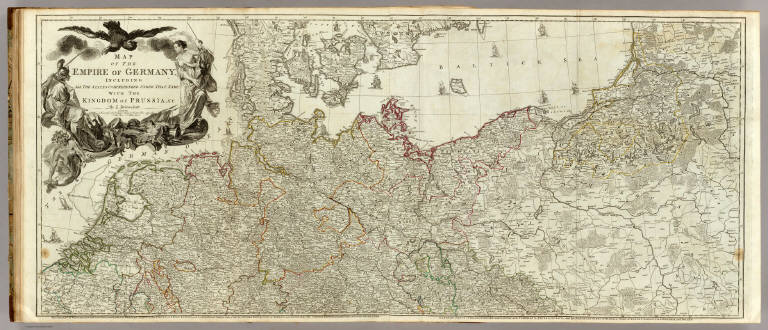
Delarochette, Louis Stanislas d'Arcy
Full Title
Map of the Empire of Germany, including all the states comprehended under that name: with the Kingdom of Prussia, &c. (Northern section). By L. Delarochette. (T. Kitchin, sculpt.) London, printed for Robt. Sayer, Map & Print Seller, opposite Fetter Lane in Fleet Street, (1790?)
List No
0411.022
Note
Engraved map in outline color. Printed on 2 sheets with titles: The Circles of Westphalia, and Lower Saxony, with the western parts of the Circle of Upper Saxony, and the northern parts of the Circle of Upper Rhine, part of Sweden, and Denmark; the United Provinces, and part of the Netherlands -- Eastern parts of Brandenburg and Saxony, with Pomerania, Prussia, Lusatia, and the northern parts of Silesia; part of Sweden, Samogitia, Lithuania, and Poland. Shows vegetation, banks, etc. Relief shown pictorially. Prime meridian: Ferro. Ornamental title cartouche. David Rumsey Collection copy mounted as 1 sheet.
Author
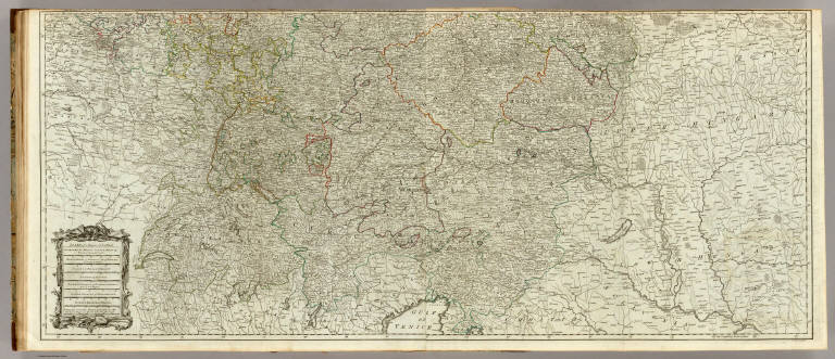
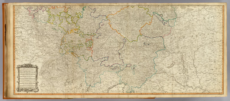
Delarochette, Louis Stanislas d'Arcy
Full Title
(Map of the Empire of Germany, including all the states comprehended under that name: with the Kingdom of Prussia, &c. Southern section. By L. Delarochette). T. Kitchin, sculpt. (London, printed for Robt. Sayer, Map & Print Seller, opposite Fetter Lane in Fleet Street, 1790?)
List No
0411.023
Note
Engraved map in outline color. Printed on 2 sheets with titles: The Circles of Lower Rhine, Franconia, Swabia, Bavaria, with the southern parts of the Circles of ... -- Eastern parts of Bohemia, and of the Circle of Austria ... Shows vegetation, etc. Relief shown pictorially. Prime meridian: Ferro. Ornamental title cartouche. David Rumsey Collection copy mounted as 1 sheet; portions of sheet titles in upper margin missing.
Author
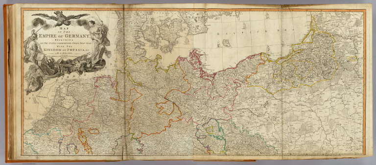
Delarochette, Louis Stanislas d'Arcy
Full Title
(Composite of) Map of the Empire of Germany, including all the states comprehended under that name: with the Kingdom of Prussia, &c. By L. Delarochette. T. Kitchin, sculpt. London, printed for Robt. Sayer, Map & Print Seller, opposite Fetter Lane in Fleet Street, (1790?)
List No
0411.024
Note
Engraved map in outline color. Printed on 4 sheets. Shows vegetation, banks, etc. Relief shown pictorially. Prime meridian: Ferro. Ornamental title cartouche. David Rumsey Collection copy mounted as 2 sheets; portions of sheet titles in upper margin of lower sheets missing.
Author
[Faden, William, 1749-1836, Diquemare, Abbé, Delarochette, L. (Louis), 1731-1802]
Full Title
A chart of the British Channel and the Bay of Biscay with a part of the North Sea, and the entrance of St. George's Channel. By Monsr. L. Abbé Diquemare, with several emendations, and many useful additions &c. By L. S. de la Rochette. 3d. Edition MDCCXCIV. London. Engraved & published as the Act directs by W. Faden, Sucer. to the late T. Jeffreys, Geogr. to the King. Charing Cross, Sept. 17th. 1794.
List No
14383.015
Note
Nautical chart of the British [English] Channel, Bay of Biscay, North Sea and Saint George's Channel, as of 1794. Shows political boundaries, cities, roads, canals, topography, bodies of water, drainage, coastlines, islands, sand banks, depths and anchorage. Relief shown with hachures. Includes latitudinal and longitudinal lines, as well as rhumb lines and a compass rose with north oriented toward top of sheet. Indexed to indicate land characteristics, such as, "Soft, clean ground, shells and awl points." Descriptive text throughout, including notes on voyages. Hand-colored engraving. Map is 50 x 87 cm, on fold-out sheet 55 x 94 cm. With stamp: Liverpool Library.
Author
[Faden, William, 1749-1836, Delarochette, L. (Louis), 1731-1802]
Full Title
A chart of the Islands of Jersey and Guernsey, Sark, Herm and Alderney; with the adjacent coast of France. By L. S. de la Rochette. MDCCLXXXI. London. Engraved & published as the Act directs, Jany. 1st. 1781, by W. Faden, Successor to the late T. Jeffreys, Geogr. to the King. Charing Cross.
List No
14383.016
Note
Nautical chart of the Islands of Jersey and Guernsey, Sark, Herm and Alderney, as of 1781. Shows political boundaries, cities, roads, canals, topography, bodies of water, drainage, coastlines, islands, sand banks, depths and anchorage. Relief shown with hachures. Includes latitudinal and longitudinal lines, as well as a legend, rhumb lines and compass rose with north oriented toward top of sheet. Descriptive text throughout, including notes on voyages. With eleven profile views, including: Profile of Jersey, from south to north -- Profile of Guernsey, from south to north. Hand-colored engraving. Map is 69 x 50 cm, on double sheet 75 x 55 cm. With stamp: Liverpool Library.
Author
[Faden, William, 1749-1836, Delarochette, L. (Louis), 1731-1802]
Full Title
A chart of the coasts of Spain and Portugal, with the Balearic Islands, and part of the coast of Barbary. By L. S. de la Rochette. MDCCLXXX. 2nd. Edition. London : engraved & published as the Act directs, by Wm. Faden, successr. to the late T. Jeffreys, Geogr. to the King, Charing Cross, June 28th, 1780.
List No
14383.024
Note
Nautical chart of the coasts of Spain and Portugal, including the Balearic Islands and the Barbary Coast, as of 1780. Shows political boundaries, cities, roads, canals, topography, bodies of water, drainage, coastlines, islands, depths and anchorage. Relief shown with hachures. Includes latitudinal and longitudinal lines, as well as rhumb lines. Descriptive text throughout, such as historical notes and descriptions of the landscape, such as, "Along this coast the ground in general consists of gravel, with sand & bits of rotten shells". Hand-colored engraving. Map is 50 x 70 cm, on double sheet 55 x 75 cm. With stamp: Liverpool Library.
Author
Faden, William, 1749-1836
Full Title
Carte de l'Isle de Corse tireé sur les lieux par ordre de Mr. Le Marêchal de Maillebois. -- Carte de l'Isle de Sardaigne. Published by W. Faden, Geogr. to His Majesty and to H. R. H. the Prince of Wales, Charing Cross.
List No
14383.031
Note
Two maps of Corsica, France, and Sardinia, Italy, as of 1794. Maps show regions, cities, roads, topography, bodies of water, drainage, coastlines and islands. Relief shown pictorially. Maps include explanatory notes and four bar scales. Second map indexed to indicate place names. Hand-colored engraving. Together, maps are 41 x 47 cm, on double sheet 55 x 75 cm. With stamp: Liverpool Library.
Author
Faden, William, 1749-1836
Full Title
Nouvelle carte de la Suisse dans laquelle sont exactement distingués les treize cantons, leurs alliés, et leurs sujets. Dressée sur les Mémoires les plus corrects, et assujettie aux Observations Astronomiques à Londre chez W. Faden, Charing Cross, 1773. Printed for W. Faden, the Corner of St. Martins Lane, Charing Cross; as the Act directs.
List No
14383.032
Note
Map of Switzerland, as of 1773. Shows political boundaries, cities, roads, topography, vegetation, bodies of water and drainage. Relief shown pictorially. Includes latitudinal and longitudinal lines, as well as four bar scales and descriptive note. Indexed to indicate place names. With two inset maps: Vue de la Vallée de Chamouny et des Glacieres du Côte du Midi, prise de l'Eglise de Chamouny en 1742 -- Section des principales Montagnes a l'Est-sud-Est, et au Sud de Geneve telles qu'on les voit de la Plaine de Cette Ville. Decorative cartouches. Hand-colored engraving. Map is 61 x 82 cm, on fold-out sheet 67 x 90 cm. With stamp: Liverpool Library.
Author
[Faden, William, 1749-1836, Delarochette, L. (Louis), 1731-1802]
Full Title
Scandia or Scandinavia, comprehending Sweden, and Norway, with the Danish Islands, to which is added the remainder of the possessions of Denmark. By L. S. de la Rochette. London. Published by Wm. Faden, Geographer to the King, and to His R. H. the Prince of Wales, February 10th. 1794. Wm. Palmer sculp.
List No
14383.037
Note
Map of Scandinavia, including Sweden, Norway and Denmark, as of 1790. Shows political boundaries, cities, roads, topography, vegetation, bodies of water, drainage, coastlines, islands and water routes. Relief shown pictorially. Includes latitudinal and longitudinal lines, as well as six bar scales. With an explanation of terms for geographic entities - lake, island, river and mountain - in Scandinavian languages. Decorative cartouches. Hand-colored engraving. Map is 70 x 49 cm, on double sheet 75 x 55 cm.
Author
[Faden, William, 1749-1836, Delarochette, L. (Louis), 1731-1802]
Full Title
Greece, Archipelago and part of Anadoli. By L. S. de la Rochette, MDCCXC. London, published for Willm. Faden, Geographer to the King, January 1st. 1791.
List No
14383.039
Note
Map of Greece, as of 1790. Shows political boundaries, cities, roads, topography, vegetation, bodies of water, drainage, coastlines and islands. Relief shown pictorially. Includes latitudinal and longitudinal lines, as well as six bar scales and descriptive text. Decorative cartouche. Hand-colored engraving. Map is 54 x 75 cm, on fold-out sheet 55 x 82 cm. With stamp: Liverpool Library.
Author
[Faden, William, 1749-1836, Delarochette, L. (Louis), 1731-1802]
Full Title
Hind, Hindoostan, or India. By L. S. de la Rochette, MDCCLXXXVIII. London, published by William Faden, Geographer to the King, as the Act directs, Jany. 1st. 1788. W. Palmer sculp.
List No
14383.043
Note
Map of India, as of 1788. Shows political boundaries, cities, roads, topography, bodies of water, drainage, coastlines, islands and sand banks. Features European colonial states. Relief shown pictorially. Includes latitudinal and longitudinal lines, as well as a legend and four bar scales. Decorative cartouche. Hand-colored engraving. Map is 71 x 53 cm, on double sheet 75 x 55 cm. With stamp: Liverpool Library.
Author
[Faden, William, 1749-1836, Delarochette, L. (Louis), 1731-1802]
Full Title
The Dutch Colony of the Cape of Good Hope. By L. S. de la Rochette. MDCCLXXXII. Engraved by W. Faden. London, published by W. Faden, successor to the late T. Jeffreys, Geogr. to the King, Charing Cross, March 20th, 1782.
List No
14383.051
Note
Map of the Cape of Good Hope, as of 1782. Shows political boundaries, cities, roads, topography, bodies of water, drainage, coastlines, islands, sand banks and depths. Relief shown pictorially. Includes latitudinal and longitudinal lines, as well as three bar scales. Indexed to indicate place names. Decorative cartouche. Descriptive text throughout. Black and white engraving. Map is 49 x 32 cm, on sheet 55 x 37 cm. With stamp: Liverpool Library.
Author
[Faden, William, 1749-1836, Delarochette, L. (Louis), 1731-1802]
Full Title
A chart of the Antilles, or, Charibbee, or, Caribs Islands, with the Virgin Isles. By L. S. Rochette MDCCLXXXIV. London, published by Wm. Faden, Geographer to the King, Charing-Cross, March 1st, 1784. W. Palmer sculp.
List No
14383.059
Note
Nautical chart of the Antilles and Virgin Islands, as of 1784. Shows political boundaries, cities, ports, topography, bodies of water, drainage, coastlines, islands, sand banks and depths. Relief shown pictorially. Includes latitudinal and longitudinal lines, as well as rhumb lines, a compass roses with north oriented toward top of sheet, and faces indicating the direction of wind. Explanatory note: From the situation of the Caribs Islands, compared with that of the westernmost isles of the Mexican Gulf, they are named Windward Islands by the Spaniards, as well as by the French, the Dutch, and the Danes, while the English, who consider the position of those Islands respectively to Barbardoes give them the name of Leeward Islands, or Leeward Charibbee Islands. Decorative cartouche. With inset map: Positions ascertained by courses and distances given, on a scale reduced to the third. With twenty-three profile views, including: Anegada -- Appearance of the easternmost Virgins. Hand-colored engraving. Map is 45 x 43 cm, on fold-out sheet 55 x 50 cm. With stamp: Liverpool Library.
Author
[Faden, William, 1749-1836, Delarochette, L. (Louis), 1731-1802]
Full Title
The coast of Guyana from the Oroonoko to the River of Amazons and the inland parts as far as they have been explored by the French & Dutch engineers with the Islands of Barbadoes, Tobago &ca. from the observations of Captain Edward Thompson made in the Hyæna, in the year 1781, when he commanded in the Rivers Berbice, Essequebo and Demerari, and governed those colonies after their conquest from the Dutch. By L. S. de la Rochette, MDCCLXXXIII. London. Engraved & published by Willm. Faden, Geographer to the King, Charing-Cross, Octor. 6th. 1783.
List No
14383.060
Note
Nautical chart of the Guyanan Coast, from the Oroonoko River to the Amazon River, as of 1783. Shows political boundaries, cities, ports, topography, bodies of water, drainage, coastlines, islands, sand banks and depths. Relief shown pictorially. Includes latitudinal and longitudinal lines, as well as rhumb lines, a compass roses with north oriented toward top of sheet, and arrows indicating the direction of water flow. Decorative cartouche. With four inset maps: Entrance of River Berbice -- Surinam River, from the Dutch -- Port of Cayenne, from the French -- The entrances of the Rivers Essequebo and Demerari. With two profile views: The entrance of Demerari River -- Appearance of the land about Cayenne. Hand-colored engraving. Map is 50 x 64 cm, on double sheet 50 x 55 cm. With stamp: Liverpool Library.
Author
[Delarochette, Louis Stanislas d'Arcy, Robert Laurie & James Whittle]
Full Title
Map of the Empire of Germany, including all the states comprehended under that name: with the Kingdom of Prussia, &c. (North half). By L. Delarochette. London, Published by Laurie & Whittle, No. 53, Fleet Street, 12th May, 1794. (T. Kitchin sculpt.)
List No
2310.038
Note
Hand colored engraved map. Relief shown pictorially. Printed on 2 sheets; joined. Contents: The circles of Westphalia and Lower Saxony, with the western parts of the Circle of Upper Saxony, and the northern parts of the Circle of Upper Rhine, part of Sweden, and Denmark; the United Provinces, and part of the Netherlands -- Eastern parts of Brandenburg and Saxony, with Pomerania, Prussia, Lusatia, and the northern parts of Silesia; part of Sweden, Samogitia, Lithuania, and Poland.
Author
Kitchin, Thomas
Full Title
(Map of the Empire of Germany, including all the states comprehended under that name: with the Kingdom of Prussia, &c. South half. By L. Delarochette. London, Published by Laurie & Whittle, No. 53, Fleet Street, 12th May, 1794)
List No
2310.039
Note
Hand colored engraved map. Relief shown pictorially. Printed on 2 sheets; joined. Contents: The circles of Lower Rhine, Franconia, Swabia and Bavaria, with the southern parts of the circles of Upper Rhine and Saxony, the western parts of Bohemia and of the circle of Austria, Switzerland and part of Italy, France and the Netherlands -- Eastern parts of Bohemia and of the Circle of Austria, with Moravia, and the southern parts of Silesia; part of Poland, Hungary, Sclavonia, Croatia, and Istria.
Author
[Delarochette, Louis Stanislas d'Arcy, Robert Laurie & James Whittle]
Full Title
(Composite of) Map of the Empire of Germany, including all the states comprehended under that name: with the Kingdom of Prussia, &c. By L. Delarochette. London, Published by Laurie & Whittle, No. 53, Fleet Street, 12th May, 1794. T. Kitchin sculpt.
List No
2310.040
Note
Digital composite of 2 hand colored engraved maps (printed on 4 sheets). Relief shown pictorially. Contents: The circles of Westphalia and Lower Saxony, with the western parts of the Circle of Upper Saxony, and the northern parts of the Circle of Upper Rhine, part of Sweden, and Denmark; the United Provinces, and part of the Netherlands -- Eastern parts of Brandenburg and Saxony, with Pomerania, Prussia, Lusatia, and the northern parts of Silesia; part of Sweden, Samogitia, Lithuania, and Poland -- The circles of Lower Rhine, Franconia, Swabia and Bavaria, with the southern parts of the circles of Upper Rhine and Saxony, the western parts of Bohemia and of the circle of Austria, Switzerland and part of Italy, France and the Netherlands -- Eastern parts of Bohemia and of the Circle of Austria, with Moravia, and the southern parts of Silesia; part of Poland, Hungary, Sclavonia, Croatia, and Istria.
Author
[Delarochette, Louis Stanislas d'Arcy, Faden, William, 1750?-1836]
Full Title
A chart of the islands of Jersey and Guernsey, Sark, Herm and Alderney; with the adjacent coast of France. By L.S. De la Rochette. MDCCLXXXI. London: engraved & published as the Act directs Jany. 1st, 1781 by W. Faden, successor to the late T. Jefferys, Geogr. to the King, Charing Cross.
List No
2104.010
Note
Hand col. engraved map. Relief shown by hachures; depths by soundings. Shows rocks and redoubts or guardhouses on the French coast, anchorages, etc. Includes 11 coastal profiles. "10" on verso.
Author
[Delarochette, Louis Stanislas d'Arcy, Dicquemare, Abbe (Jacques Francois), 1733-1789, Faden, William, 1750?-1836]
Full Title
A chart of the British Channel and the Bay of Biscay, with a part of the North Sea, and the entrance of St. George's Channel. By Monsr. L. Abbe Diquemare (i.e. Dicquemare), with several emendations, and many useful additions &c. by L.S. De la Rochette. 3d. edition, MDCCXCIV. London, engraved & published as the Act directs by W. Faden, succr. to the late T. Jefferys, Geogr. to the King. Charing Cross, Sept. 17th, 1794.
List No
2104.011
Note
Hand col. engraved map. Relief shown pictorially; depths by soundings. "11" on verso.
Author
[Delarochette, Louis Stanislas d'Arcy, Faden, William, 1750?-1836]
Full Title
The North Sea with the Kattegat, from the chart of Messrs. De Verdun, De Borda, and Pingre, made public in 1777, by order of Louis XVI; constructed on a larger scale and with considerable additions and emendations by L.S. De la Rochette, M.DCC.XCVI. London, published by W. Faden, Geographer to the King and to H.R.H. the Prince of Wales. Charing Cross, June 1796. Engraved by Thomas Foot.
List No
2104.012
Note
Engraved map; outline hand color. Relief shown pictorially; depths by soundings. Includes table of latitudes and longitudes. "12" on verso.
Author
[Delarochette, Louis Stanislas d'Arcy, Faden, William, 1750?-1836]
Full Title
A chart of the coasts of Spain and Portugal, with the Balearic Islands, and part of the coast of Barbary. By L.S. De la Rochette. MDCCLXXX. 2d. edition. London: engraved & published as the Act directs, by Wm. Faden, successr. to the late T. Jefferys, Geogr. to the King. Charing Cross, June 28th, 1780.
List No
2104.021
Note
Engraved map. Outline hand col. Depths shown by soundings. Shows ports, sailing directions, etc. "21" on verso.
Author
[Delarochette, Louis Stanislas d'Arcy, Faden, William, 1750?-1836]
Full Title
Italy with the addition of the southern parts of Germany as far as Pettau in Stiria; Murlakia, Dalmatia, the adjacent countries, and all the Illyric Islands, by L.S. De la Rochette. (North sheet). 2d. edition describing the new divisions. London, published by Willm. Faden, Geographer to the King and to H.R.H. the Prince of Wales, Charing Cross, Septr. 12th, 1800.
List No
2104.026
Note
Engraved map. Full hand col. Relief shown pictorially. Shows settlements, common and post roads, etc. Includes Corsica. "25" on verso. Printed on 2 sheets. David Rumsey Collection copy: sheets mounted as 1.
Full Title
(Italy with the addition of the southern parts of Germany as far as Pettau in Stiria; Murlakia, Dalmatia, the adjacent countries, and all the Illyric Islands, by L.S. De la Rochette. South sheet. 2d. edition describing the new divisions. London, published by Willm. Faden, Geographer to the King and to H.R.H. the Prince of Wales, Charing Cross, Septr. 12th, 1800)
List No
2104.027
Note
Engraved map. Full hand col. Relief shown pictorially. Shows settlements, common and post roads, etc. Includes Sardinia, Sicily and Malta. "26." Printed on 2 sheets. David Rumsey Collection copy: sheets mounted as 1.
Author
[Delarochette, Louis Stanislas d'Arcy, Faden, William, 1750?-1836]
Full Title
(Composite of) Italy with the addition of the southern parts of Germany as far as Pettau in Stiria; Murlakia, Dalmatia, the adjacent countries, and all the Illyric Islands, by L.S. De la Rochette. 2d. edition describing the new divisions. London, published by Willm. Faden, Geographer to the King and to H.R.H. the Prince of Wales, Charing Cross, Septr. 12th, 1800.
List No
2104.028
Note
Engraved map on 2 sheets. Full hand col. Relief shown pictorially. Shows settlements, common and post roads, etc. Includes Corsica, Sardinia, Sicily and Malta. Printed on 4 sheets. David Rumsey Collection copy: sheets mounted as 2 sheets.
Author
[Delarochette, Louis Stanislas d'Arcy, Faden, William, 1750?-1836]
Full Title
Scandia or Scandinavia, comprehending Sweden and Norway, with the Danish islands; to which is added the remainder of the possessions of Denmark. By L.S. Delarochette. London: published by Wm. Faden, Geographer to the King, and to His R.H. the Prince of Wales, February 10th, 1794. Wm. Palmer sculp.
List No
2104.034
Note
Engraved map. Full hand col. Relief shown pictorially. Illustrated cartouche. "32" on verso.
Author
[Delarochette, Louis Stanislas d'Arcy, Faden, William, 1750?-1836]
Full Title
Greece, Archipelago and part of Anadoli. By L.S. de la Rochette, MDCCXC. London. Published for Willm. Faden, Geographer to the King. January 1st, 1791. W. Palmer sculp.
List No
2104.041
Note
Engraved map. Outline hand col. Relief shown pictorially. Includes illustrated cartouche by: C. Meta fec. "39" on verso.
Author
[Delarochette, Louis Stanislas d'Arcy, Faden, William, 1750?-1836]
Full Title
Hind, Hindoostan, or India. By L.S. de la Rochette. MDCCLXXXVIII. London, published by William Faden, Geographer to the King and to H.R.H. the Prince of Wales. 3d. edition with considerable improvements, June 1st, 1800. Wm. Palmer, sculp.
List No
2104.044
Note
Engraved map. Full hand col. Relief shown pictorially. Illustrated cartouche by "D.L.R. inv & del." with motto: Tu regere imperio populos brittanne memento. "42" on verso.
Author
[Delarochette, Louis Stanislas d'Arcy, Faden, William, 1750?-1836]
Full Title
Africa. Auctor L.S. de la Rochette, 1782. London, published by W. Faden, Geographer to His Majesty and to H.R.H. the Prince of Wales, Charing Cross, Augt. 12th, 1803. Engraved by W. Palmer.
List No
2104.049
Note
Engraved map. Full hand col. Relief shown pictorially. Includes inset of the Azores and descriptive note. Projection interrupted at the Equator. Title shown in medallion with "In Nummo Hadriani, Lib. Cap. 5, p. 34, edit Gronovii." "London, published April 25, 1803 by Wm. Faden, Charing Cross" in lower margin. "46" on verso.
Author
[Delarochette, Louis Stanislas d'Arcy, Faden, William, 1750?-1836]
Full Title
Lower Egypt and the adjacent deserts, with a part of Palestine; to which has been added the nomenclature of the Roman age by L.S. de la Rochette, MDCCCII. London, published by William Faden, Geographer to the King and to H.R.H. the Prince of Wales, Charing Cross, Jan. 1st, 1802.
List No
2104.050
Note
Engraved map. Full hand col. Relief shown by hachures. Shows roads, walls, wells, anchorages, etc. "47" on verso.
Author
[Delarochette, Louis Stanislas d'Arcy, Faden, William, 1750?-1836]
Full Title
The Dutch Colony of the Cape of Good Hope by L.S. de la Rochette. M. DCC. XCV. Engraved by W. Faden. London: published by W. Faden, successor to the late T. Jefferys, Geogr. to the King, Charing Cross, 2d. edition corrected Decr. 1st, 1795.
List No
2104.051
Note
Engraved map. Border hand col. Relief shown pictorially; depths by soundings. Shows kraals or villages, fountains, river crossings, early settlers, anchorages, etc. Illustrated cartouche. "48."
Author
[Delarochette, Louis Stanislas d'Arcy, Faden, William, 1750?-1836]
Full Title
A general chart of the West India Islands with the adjacent coasts of the Spanish continent, by L.S. de la Rochette. M. DCCXCVI. London, published by W. Faden, Geographer to the King, and to H.R.H. the Prince of Wales, September 22d., 1796.
List No
2104.055
Note
Engraved map. Coasts in outline hand col. Relief shown pictorially; depths by soundings. "52" on verso.
Author
[Delarochette, Louis Stanislas d'Arcy, Faden, William, 1750?-1836]
Full Title
A chart of the Antilles, or Charibbee, or Caribs Islands, with the Virgin Isles, by L.S. de la Rochette, MDCCLXXXIV. London: published by Wm. Faden, Geographer to the King, Charing-Cross, March 1st, 1784. W. Palmer, sculp.
List No
2104.056
Note
Engraved map. Full hand col. Relief shown pictorially. Inset map: Positions ascertained by courses and distances given; on a scale reduced the the third. Includes 23 coastal profiles. "53" on verso.
Author
[Delarochette, Louis Stanislas d'Arcy, Faden, William, 1750?-1836, Thompson, Edward, Capt.]
Full Title
The coast of Guyana from the Oroonoko to the River of Amazons and inland parts as far as they have been explored by the French & Dutch engineers, with the islands of Barbadoes, Tobago &ca. From the observations of Captain Edward Thompson, made in the Hyaena, in the year 1781, when he commanded in the rivers Berbice, Essequebo and Demerari, and governed those colonies after their conquest from the Dutch. By L.S. de la Rochette. MDCCLXXXIII. (with) Entrance of River Berbice by Captn. E.T. (with) Surinam River from the Dutch -- Port of Cayenne from the French. (with) The entrances of the rivers Essequebo and Demerari by Captain Thompson. London, engraved & published by Willm. Faden, Geographer to the King, Charing-Cross; Octor. 6th, 1783.
List No
2104.060
Note
Engraved map. with 4 inset maps. Outline hand col. Relief shown pictorially; depths by soundings. Includes notes and table of astronomical observations. "This geohydrographic survey of Guyana is inscribed to the merchants of Barbadoes and Guyana ... by ... Edw. Thompson." "Approved by the Chart Committee of the Admiralty." "55" on verso.
Author
[Wyld, James, 1812-1887, Wyld, James, 1790-1836]
Full Title
Persia : Ancient and modern. London. Published by J. Wyld. 1838. (to accompany) A new general atlas of modern geography : consisting of a complete collection of maps of the four quarters of the globe ...
List No
13170.039
Note
Engraved map of Persian Empire, hand colored in outline. "Indiae Veteris Quatenus Macedonibus Nota Fuit Finitimarumque Regionum Specimen Geographicum ... Auctor L.S. DeLaRochette ". Shows administrative boundaries, major cities and towns. Relief shown by hachures. Prime meridian is Greenwich.
Author
[Wyld, James, 1812-1887, Wyld, James, 1790-1836]
Full Title
Africa. In Nummo Hadriani, Lib. Cap. 5, p. 34, edit Gronovii. auctor, L.S. De La Rochette. Engraved by W. Palmer. London. Published by James Wyld. 1838. (to accompany) A new general atlas of modern geography : consisting of a complete collection of maps of the four quarters of the globe ...
List No
13170.049
Note
Double page engraved map, hand colored in outline. With inset: Azores or Western Islands. Projection interrupted at the Equator. Shows political boundaries, major cities and towns. Relief shown by hachures and pictorially. Prime meridian is Greenwich.
Author
[Wyld, James, 1812-1887, Wyld, James, 1790-1836]
Full Title
Lower Egypt and the adjacent deserts, with a part of Palestine : to which has been added the nomenclature of the Roman age. By L. S. De La Rochette. London. Published by James Wyld. 1838. (to accompany) A new general atlas of modern geography : consisting of a complete collection of maps of the four quarters of the globe ...
List No
13170.050
Note
Double page engraved map, hand colored in outline. Shows political boundaries, major cities and towns. Relief shown by hachures.
Author
[Delarochette, Louis Stanislas d'Arcy, Faden, William, 1750?-1836, Thompson, Edward, Capt.]
Full Title
(Facsimile) Thompson - 1783. 43. S Doc 91 55 2. Part of a Chart of the Coast of Guiana by L.S. Delarochette, 1783, from Observations by Capt. Edward Thompson in 1781; London, Published by Wm. Faden, 1783. Reproduced from Original Furnished the Commission by te Republic of Venezuela. Photo.Lith. by A. Hoen & Co., Baltimore, MD.
List No
1122.048
Note
Tinted.
1-39 of 39
|