Who What Where When |
Author
Patteson, Edward
Full Title
Russia in Europe. E.P. delint. Hewitt, sc., Bloomsbury. Published June 15, 1804, by the Rev. E. Patteson, M.A., Richmond, Surrey.
List No
2319.031
Note
Engraved outline map to be completed by students. Faces a corresponding map with place names, etc. Relief shown pictorially.
Author
Patteson, Edward
Full Title
Russia in Europe. E.P. delin. Hewitt, sc., Litte Russel St., Bloomsy. Published June 15, 1804, by the Revd. E. Patteson, M.A., Richmond, Surrey.
List No
2319.032
Note
Engraved map. Subdivisions boundaries in outline color. Faces a corresponding outline map. Relief shown by hachures. Shows settlements, etc. Place names in Latin and English.
Author
Patteson, Edward
Full Title
United States of America. E.P. delin. Hewitt, sc., Bloomsbury. (1804)
List No
2319.033
Note
Engraved outline map to be completed by students. Faces a corresponding map with place names, etc. Relief shown pictorially. Outline map showing holdings of land companies northwest of Ohio River, drainage features, location of towns, Indian tribes and political boundaries.
Author
Patteson, Edward
Full Title
United States of America. E.P. delin. Hewitt, sculp., Litt. Russel St., Bloomsbury. Published June 15th, 1804, by the Rev. E. Patteson, M.A., Richmond, Surrey.
List No
2319.034
Note
Engraved map. State boundaries in outline color. Faces a corresponding outline map. Relief shown pictorially. Shows settlements, Indian tribes, holdings of land companies northwest of Ohio River, etc.
Author
Thomson, John
Full Title
(Contents to) A new general atlas, consisting of a series of geographical designs, on various projections, exhibiting the form and component parts of the globe; and a collection of maps and charts, delineating the natural and political divisions of the empires, kingdoms, and states in the World. Constructed from the best systematic works, and the most authentic voyages and travels. With a memoir of the progress of geography, a summary of physical geography, and a consulting index to facilitate the finding out of places. Edinburgh: Printed by George Ramsay and Company, for John Thomson and Company, Edinburgh; Baldwin, Cradock, and Joy, London; and John Cumming, Dublin. 1817.
List No
1007C
Note
Lists contents of major parts of the atlas. Includes dedication by Thompson to Alexander Keith and (Keith's?) coat of arms by "Hewitt sculp., Grafton Str. East."
Author
Thomson, John
Full Title
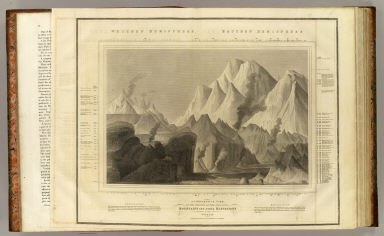
A comparative view of the heights of the principal mountains and other elevations in the World. Drawn & engraved for Thomson's New general atlas by W. & D. Lizars, Edinburgh. (1817)
List No
1007.001
Note
Engraved view. Includes vertical scale with names of heights.
Author
Thomson, John
Full Title
British Isles. Drawn & engraved by Hewitt, Broad Str., Bloomsby. Drawn & engraved for Thomson's New general atlas, May 1st, 1815.
List No
1007.010
Note
Engraved map. Hand colored. Relief shown by hachures. Includes inset of Orkney and Shetland islands.
Author
Thomson, John
Full Title
Scotland. Drawn & engraved by Hewitt, Broad Str(ee)t., Bloomsbury. Drawn and engraved for Thomson's New general atlas. April 1st, 1815.
List No
1007.012
Note
Engraved map. Hand colored. Relief shown by hachures. Includes inset of the Shetland and Orkney islands.
Author
Thomson, John
Full Title
Remote British islands. Drawn & engraved by N.R. Hewitt, Grafton Strt., East Tottenham Court Road. Drawn & engraved for Thomson's New general atlas. Jany. 1st, 1817.
List No
1007.014
Note
Five engraved maps and 2 views. Outline hand color. Relief shown by hachures. Contents: Isles of Guernsey, Herm, Sark and Alderney. Scale 1:250,000 -- Isle of Jersey. Scale 1:150,000 -- Isles of Scilly. Scale 1:120,000 -- Isle of Mann. Scale 1:180,000 -- Isle of Wight. Scale 1:160,000 -- View of Eddystone Light House -- Freshwater Bay, in the Isle of Wight, with a distant view of the Needle Rocks.
Author
Thomson, John
Full Title
Venetian States. Drawn & engraved by N.R. Hewitt, Charlotte Str(ee)t, Fitzroy Square. Drawn and engraved for Thomson's New general atlas, 1816.
List No
1007.028
Note
Engraved map. Hand colored.
Author
Thomson, John
Full Title
Russian Empire. N.R. Hewitt Sc., 10 Broad Str., Bloomsby., London. Drawn & engraved for John Thomson & Co.'s New general atlas, 12 August 1814.
List No
1007.039
Note
Engraved map. Outline hand color. Relief shown by hachures.
Author
Thomson, John
Full Title
Tartary. N.R. Hewitt sc., 10 Broad Str., Bloomsbry., London. Drawn and engraved for Thomson's New general atlas, Sepr. 1st., 1814.
List No
1007.040
Note
Engraved map. Outline hand color. Relief shown by hachures.
Author
Thomson, John
Full Title
Egypt. Abyssinia. Engraved by N.R. Hewitt. Drawn & engraved for Thomson's New general atlas, 1817.
List No
1007.053
Note
Two engraved maps on 1 sheet. Hand colored. Relief shown by hachures. Includes descriptive notes.
Author
Thomson, John
Full Title
North America. N.R. Hewitt sc., 10 Broad Str., Bloomsby., London. Drawn and engraved for Thomson's New general atlas, 1814.
List No
1007.058
Note
Engraved map. Hand colored. Relief shown by hachures. Coloring differs from other copy.
Author
Thomson, John
Full Title
North America. N.R. Hewitt sc., 10 Broad Str., Bloomsby., London. Drawn and engraved for Thomson's New general atlas, 1814.
List No
1007.059
Note
Engraved map. Hand colored. Relief shown by hachures. Unlike other copy, this shows coasts of Hudson's Bay, Labrador and Upper and Lower Canada in yellow, and also has annotations.
Author
Thomson, John
Full Title
Northern provinces of the United States. (with view) The Great Falls of Niagara. Hewitt sc., Grafton Str. E(a)st, Tottenham Ct. Rd. Drawn & engraved for Thomson's New general atlas, 1817.
List No
1007.062
Note
Engraved map. Hand colored. Relief shown by hachures.
Author
Thomson, John
Full Title
Southern provinces of the United States. (with view) Characteristic scenery of the Hudson River. Hewitt sc., Grafton Str. East, Tottenham Court Rd. Drawn & engraved for Thomson's New general atlas, 1817.
List No
1007.063
Note
Engraved map. Hand colored. Relief shown by hachures. Shows settlements, Indian tribes, etc.
Author
Thomson, John
Full Title
A chart of New South Wales, Van Diemen's Land. Surveys in the interior of New South Wales. (with) Van Diemen's Land, from the most recent authorities and surveys. (with) Part of Australasia. (with) British settlements at Port Jackson, &c. J. Aspin, del. Hewitt sculp., Buckingham Place. (Drawn & engraved for Thomson's New general atlas, 1821)
List No
1007.081
Note
Engraved map with 3 insets. Hand colored. Relief shown by hachures. An added sheet.
Author
Thomson, John
Full Title
A chart of the discoveries of Captains Ross, Parry & Franklin in the Arctic Regions in the years 1818, 1819, 1820, 1821 & 1822. (with) Capt. Franklin's journey from Coppermine River to the head of Bathurst Inlet & return by Hood's River. J. Aspin delt. Hewitt sc., Buckingham Place. (Drawn & engraved for Thomson's New general atlas) (1822?)
List No
1007.082
Note
Engraved map with inset. Hand colored. David Rumsey Collection copy has the names "Mag. Pole" and "C. Garry" added in pencil. An added sheet.
Author
[Gaultier, abbe (Aloisius Edouard Camille), 1746?-1818, Wauthier, J. M.]
Full Title
A plain map or emblematic chart for the geographical game of the British Islands, according to the method of the Abbe Gaultier. By Mr. Wauthier, his pupil. 1797. Hewitt Sc.
List No
0294.001
Note
Engraved map. Hand colored. Relief shown pictorially. Shows boundaries, rivers, canals, lakes, capes, mountains, forests, mineral waters, cities, ports and bays.
Author
[Gaultier, abbe (Aloisius Edouard Camille), 1746?-1818, Wauthier, J. M.]
Full Title
A map of Europe, according to the method of the Abbe Gaultier by Mr. Wauthier, his pupil, 1799. Hewitt sc.
List No
0294.004
Note
Engraved map. Hand colored. Relief shown pictorially. Shows countries, rivers, mountains, cities, water bodies, etc. Prime meridian: Ferro.
Author
[Thomson, John, Wyld, James, 1790-1836]
Full Title
(Covers to) A General Atlas, Containing Maps illustrating some important periods in Ancient History; and distinct Maps of the several Empires, Kingdoms and States In The World, From Original Drawings according to the latest Treaties by J. Wyld and Engraved by N.R. Hewitt. Edinburgh, Printed for John Thomson & Co for Baldwin, Cradock & Joy, London & John Cumming, Dublin.
List No
2713.001
Note
This is the second edition and includes the extra map of the Arctic and two extra maps of Australia. The text adds a section on Voyages of Discovery. Two additional maps are laid in, one of South America, the other of Mexico. Half leather paper-covered boards with label pasted on front printed with title.
Author
[Thomson, John, Wyld, James, 1790-1836]
Full Title
Table of the Comparative Heights of the Principal Mountains of the World. (inset) Passes of the Alps, above the level of the sea. (to accompany) A General Atlas, Containing Maps illustrating some important periods in Ancient History; and distinct Maps of the several Empires, Kingdoms and States In The World, From Original Drawings according to the latest Treaties by J. Wyld and Engraved by N.R. Hewitt. Edinburgh, Printed for John Thomson & Co for Baldwin, Cradock & Joy, London & John Cumming, Dublin.
List No
2713.002
Note
Includes the list of the mountains, their locations and heights. This is the second edition and includes the extra map of the Arctic and two extra maps of Australia. The text adds a section on Voyages of Discovery. Two additional maps are laid in, one of South America, the other of Mexico. Half leather paper-covered boards with label pasted on front printed with title.
Author
[Thomson, John, Wyld, James, 1790-1836]
Full Title
(Title Page to) A General Atlas, Containing Maps illustrating some important periods in Ancient History; and distinct Maps of the several Empires, Kingdoms and States In The World, From Original Drawings according to the latest Treaties by J. Wyld and Engraved by N.R. Hewitt. Edinburgh, Printed for John Thomson & Co for Baldwin, Cradock & Joy, London & John Cumming, Dublin.
List No
2713.003
Note
This is the second edition and includes the extra map of the Arctic and two extra maps of Australia. The text adds a section on Voyages of Discovery. Two additional maps are laid in, one of South America, the other of Mexico. Half leather paper-covered boards with label pasted on front printed with title.
Author
[Wyld, James, 1790-1836, Thomson, John]
Full Title
(Table of Contents to) A General Atlas, Containing Maps illustrating some important periods in Ancient History; and distinct Maps of the several Empires, Kingdoms and States In The World, From Original Drawings according to the latest Treaties by J. Wyld and Engraved by N.R. Hewitt. Edinburgh, Printed for John Thomson & Co for Baldwin, Cradock & Joy, London & John Cumming, Dublin.
List No
2713.004
Note
This is the second edition and includes the extra map of the Arctic and two extra maps of Australia. The text adds a section on Voyages of Discovery. Two additional maps are laid in, one of South America, the other of Mexico. Half leather paper-covered boards with label pasted on front printed with title.
Author
[Thomson, John, Wyld, James, 1790-1836]
Full Title
(Text page to) A General Atlas, Containing Maps illustrating some important periods in Ancient History; and distinct Maps of the several Empires, Kingdoms and States In The World, From Original Drawings according to the latest Treaties by J. Wyld and Engraved by N.R. Hewitt. Edinburgh, Printed for John Thomson & Co for Baldwin, Cradock & Joy, London & John Cumming, Dublin.
List No
2713.005
Note
This is the second edition and includes the extra map of the Arctic and two extra maps of Australia. The text adds a section on Voyages of Discovery. Two additional maps are laid in, one of South America, the other of Mexico. Half leather paper-covered boards with label pasted on front printed with title.
Author
[Thomson, John, Wyld, James, 1790-1836]
Full Title
(Text page to) A General Atlas, Containing Maps illustrating some important periods in Ancient History; and distinct Maps of the several Empires, Kingdoms and States In The World, From Original Drawings according to the latest Treaties by J. Wyld and Engraved by N.R. Hewitt. Edinburgh, Printed for John Thomson & Co for Baldwin, Cradock & Joy, London & John Cumming, Dublin.
List No
2713.006
Note
Text continues. This is the second edition and includes the extra map of the Arctic and two extra maps of Australia. The text adds a section on Voyages of Discovery. Two additional maps are laid in, one of South America, the other of Mexico. Half leather paper-covered boards with label pasted on front printed with title.
Author
[Thomson, John, Wyld, James, 1790-1836]
Full Title
(Text page to) A General Atlas, Containing Maps illustrating some important periods in Ancient History; and distinct Maps of the several Empires, Kingdoms and States In The World, From Original Drawings according to the latest Treaties by J. Wyld and Engraved by N.R. Hewitt. Edinburgh, Printed for John Thomson & Co for Baldwin, Cradock & Joy, London & John Cumming, Dublin.
List No
2713.007
Note
Text continues. This is the second edition and includes the extra map of the Arctic and two extra maps of Australia. The text adds a section on Voyages of Discovery. Two additional maps are laid in, one of South America, the other of Mexico. Half leather paper-covered boards with label pasted on front printed with title.
Author
[Thomson, John, Wyld, James, 1790-1836]
Full Title
(Text page to) A General Atlas, Containing Maps illustrating some important periods in Ancient History; and distinct Maps of the several Empires, Kingdoms and States In The World, From Original Drawings according to the latest Treaties by J. Wyld and Engraved by N.R. Hewitt. Edinburgh, Printed for John Thomson & Co for Baldwin, Cradock & Joy, London & John Cumming, Dublin.
List No
2713.008
Note
Text continues. This is the second edition and includes the extra map of the Arctic and two extra maps of Australia. The text adds a section on Voyages of Discovery. Two additional maps are laid in, one of South America, the other of Mexico. Half leather paper-covered boards with label pasted on front printed with title.
Author
[Thomson, John, Wyld, James, 1790-1836]
Full Title
(Text page to) A General Atlas, Containing Maps illustrating some important periods in Ancient History; and distinct Maps of the several Empires, Kingdoms and States In The World, From Original Drawings according to the latest Treaties by J. Wyld and Engraved by N.R. Hewitt. Edinburgh, Printed for John Thomson & Co for Baldwin, Cradock & Joy, London & John Cumming, Dublin.
List No
2713.009
Note
This is the second edition and includes the extra map of the Arctic and two extra maps of Australia. The text adds a section on Voyages of Discovery. Two additional maps are laid in, one of South America, the other of Mexico. Half leather paper-covered boards with label pasted on front printed with title.
Author
[Thomson, John, Wyld, James, 1790-1836]
Full Title
(Text page to) A General Atlas, Containing Maps illustrating some important periods in Ancient History; and distinct Maps of the several Empires, Kingdoms and States In The World, From Original Drawings according to the latest Treaties by J. Wyld and Engraved by N.R. Hewitt. Edinburgh, Printed for John Thomson & Co for Baldwin, Cradock & Joy, London & John Cumming, Dublin.
List No
2713.010
Note
Text continues. This is the second edition and includes the extra map of the Arctic and two extra maps of Australia. The text adds a section on Voyages of Discovery. Two additional maps are laid in, one of South America, the other of Mexico. Half leather paper-covered boards with label pasted on front printed with title.
Author
[Thomson, John, Wyld, James, 1790-1836]
Full Title
(Text page to) A General Atlas, Containing Maps illustrating some important periods in Ancient History; and distinct Maps of the several Empires, Kingdoms and States In The World, From Original Drawings according to the latest Treaties by J. Wyld and Engraved by N.R. Hewitt. Edinburgh, Printed for John Thomson & Co for Baldwin, Cradock & Joy, London & John Cumming, Dublin.
List No
2713.011
Note
Text continues. This is the second edition and includes the extra map of the Arctic and two extra maps of Australia. The text adds a section on Voyages of Discovery. Two additional maps are laid in, one of South America, the other of Mexico. Half leather paper-covered boards with label pasted on front printed with title.
Author
[Thomson, John, Wyld, James, 1790-1836]
Full Title
(Text page to) A General Atlas, Containing Maps illustrating some important periods in Ancient History; and distinct Maps of the several Empires, Kingdoms and States In The World, From Original Drawings according to the latest Treaties by J. Wyld and Engraved by N.R. Hewitt. Edinburgh, Printed for John Thomson & Co for Baldwin, Cradock & Joy, London & John Cumming, Dublin.
List No
2713.012
Note
Text continues. This is the second edition and includes the extra map of the Arctic and two extra maps of Australia. The text adds a section on Voyages of Discovery. Two additional maps are laid in, one of South America, the other of Mexico. Half leather paper-covered boards with label pasted on front printed with title.
Author
[Thomson, John, Wyld, James, 1790-1836]
Full Title
Figure of the Earth (to accompany) A General Atlas, Containing Maps illustrating some important periods in Ancient History; and distinct Maps of the several Empires, Kingdoms and States In The World, From Original Drawings according to the latest Treaties by J. Wyld and Engraved by N.R. Hewitt. Edinburgh, Printed for John Thomson & Co for Baldwin, Cradock & Joy, London & John Cumming, Dublin.
List No
2713.013
Note
Full color map. This is the second edition and includes the extra map of the Arctic and two extra maps of Australia. The text adds a section on Voyages of Discovery. Two additional maps are laid in, one of South America, the other of Mexico. Half leather paper-covered boards with label pasted on front printed with title.
Author
[Thomson, John, Wyld, James, 1790-1836]
Full Title
(Text Page to) A General Atlas, Containing Maps illustrating some important periods in Ancient History; and distinct Maps of the several Empires, Kingdoms and States In The World, From Original Drawings according to the latest Treaties by J. Wyld and Engraved by N.R. Hewitt. Edinburgh, Printed for John Thomson & Co for Baldwin, Cradock & Joy, London & John Cumming, Dublin.
List No
2713.014
Note
Includes color views. This is the second edition and includes the extra map of the Arctic and two extra maps of Australia. The text adds a section on Voyages of Discovery. Two additional maps are laid in, one of South America, the other of Mexico. Half leather paper-covered boards with label pasted on front printed with title.
Author
[Thomson, John, Wyld, James, 1790-1836]
Full Title
(Text Page to) A General Atlas, Containing Maps illustrating some important periods in Ancient History; and distinct Maps of the several Empires, Kingdoms and States In The World, From Original Drawings according to the latest Treaties by J. Wyld and Engraved by N.R. Hewitt. Edinburgh, Printed for John Thomson & Co for Baldwin, Cradock & Joy, London & John Cumming, Dublin.
List No
2713.015
Note
Text continues. Includes color views. This is the second edition and includes the extra map of the Arctic and two extra maps of Australia. The text adds a section on Voyages of Discovery. Two additional maps are laid in, one of South America, the other of Mexico. Half leather paper-covered boards with label pasted on front printed with title.
Author
[Thomson, John, Wyld, James, 1790-1836]
Full Title
(Text Page to) A General Atlas, Containing Maps illustrating some important periods in Ancient History; and distinct Maps of the several Empires, Kingdoms and States In The World, From Original Drawings according to the latest Treaties by J. Wyld and Engraved by N.R. Hewitt. Edinburgh, Printed for John Thomson & Co for Baldwin, Cradock & Joy, London & John Cumming, Dublin.
List No
2713.016
Note
Text continues. Includes color views. This is the second edition and includes the extra map of the Arctic and two extra maps of Australia. The text adds a section on Voyages of Discovery. Two additional maps are laid in, one of South America, the other of Mexico. Half leather paper-covered boards with label pasted on front printed with title.
Author
[Thomson, John, Wyld, James, 1790-1836]
Full Title
(Text Page to) A General Atlas, Containing Maps illustrating some important periods in Ancient History; and distinct Maps of the several Empires, Kingdoms and States In The World, From Original Drawings according to the latest Treaties by J. Wyld and Engraved by N.R. Hewitt. Edinburgh, Printed for John Thomson & Co for Baldwin, Cradock & Joy, London & John Cumming, Dublin.
List No
2713.017
Note
Text continues. Includes color views. This is the second edition and includes the extra map of the Arctic and two extra maps of Australia. The text adds a section on Voyages of Discovery. Two additional maps are laid in, one of South America, the other of Mexico. Half leather paper-covered boards with label pasted on front printed with title.
Author
[Thomson, John, Wyld, James, 1790-1836]
Full Title
(Text Page to) A General Atlas, Containing Maps illustrating some important periods in Ancient History; and distinct Maps of the several Empires, Kingdoms and States In The World, From Original Drawings according to the latest Treaties by J. Wyld and Engraved by N.R. Hewitt. Edinburgh, Printed for John Thomson & Co for Baldwin, Cradock & Joy, London & John Cumming, Dublin.
List No
2713.018
Note
Text continues. Includes color views. This is the second edition and includes the extra map of the Arctic and two extra maps of Australia. The text adds a section on Voyages of Discovery. Two additional maps are laid in, one of South America, the other of Mexico. Half leather paper-covered boards with label pasted on front printed with title.
Author
[Thomson, John, Wyld, James, 1790-1836]
Full Title
(Text Page to) A General Atlas, Containing Maps illustrating some important periods in Ancient History; and distinct Maps of the several Empires, Kingdoms and States In The World, From Original Drawings according to the latest Treaties by J. Wyld and Engraved by N.R. Hewitt. Edinburgh, Printed for John Thomson & Co for Baldwin, Cradock & Joy, London & John Cumming, Dublin.
List No
2713.019
Note
Text continues. Includes color views. This is the second edition and includes the extra map of the Arctic and two extra maps of Australia. The text adds a section on Voyages of Discovery. Two additional maps are laid in, one of South America, the other of Mexico. Half leather paper-covered boards with label pasted on front printed with title.
Author
[Thomson, John, Wyld, James, 1790-1836]
Full Title
(Text Page to) A General Atlas, Containing Maps illustrating some important periods in Ancient History; and distinct Maps of the several Empires, Kingdoms and States In The World, From Original Drawings according to the latest Treaties by J. Wyld and Engraved by N.R. Hewitt. Edinburgh, Printed for John Thomson & Co for Baldwin, Cradock & Joy, London & John Cumming, Dublin.
List No
2713.020
Note
Text continues. Includes color views. This is the second edition and includes the extra map of the Arctic and two extra maps of Australia. The text adds a section on Voyages of Discovery. Two additional maps are laid in, one of South America, the other of Mexico. Half leather paper-covered boards with label pasted on front printed with title.
Author
[Thomson, John, Wyld, James, 1790-1836]
Full Title
Table of the Comparative Lengths of the Principal Rivers in the World. Drawn by Wyld. Hewitt,Sc. Buckingham Place... (to accompany) A General Atlas, Containing Maps illustrating some important periods in Ancient History; and distinct Maps of the several Empires, Kingdoms and States In The World, From Original Drawings according to the latest Treaties by J. Wyld and Engraved by N.R. Hewitt. Edinburgh, Printed for John Thomson & Co for Baldwin, Cradock & Joy, London & John Cumming, Dublin.
List No
2713.021
Note
This table includes a reference indicating the mouth, course and length of the rivers in the world. The atlas is the second edition and includes the extra map of the Arctic and two extra maps of Australia. The text adds a section on Voyages of Discovery. Two additional maps are laid in, one of South America, the other of Mexico. Half leather paper-covered boards with label pasted on front printed with title.
Author
[Thomson, John, Wyld, James, 1790-1836]
Full Title
Orbis Veteribus Notus. J. Wyld del. N.R. Hewitt,Sc. Published by John Thomson & Co. Edinburgh. (to accompany) A General Atlas, Containing Maps illustrating some important periods in Ancient History; and distinct Maps of the several Empires, Kingdoms and States In The World, From Original Drawings according to the latest Treaties by J. Wyld and Engraved by N.R. Hewitt. Edinburgh, Printed for John Thomson & Co for Baldwin, Cradock & Joy, London & John Cumming, Dublin.
List No
2713.022
Note
Map of the ancient world. Outline colored boundaries. Showing Europe, northern Africa, Middle East and South Asia. The atlas is the second edition and includes the extra map of the Arctic and two extra maps of Australia. The text adds a section on Voyages of Discovery. Two additional maps are laid in, one of South America, the other of Mexico. Each map has a small vignette illustrating a subject related to the map. Half leather paper-covered boards with label pasted on front printed with title. Relief shown pictorially. (Mercator projection.)
Author
[Thomson, John, Wyld, James, 1790-1836]
Full Title
Orbis Romani, Pars Occidentalis. J. Wyld del. N.R. Hewitt,Sc. Published by John Thomson & Co. Edinburgh. (to accompany) A General Atlas, Containing Maps illustrating some important periods in Ancient History; and distinct Maps of the several Empires, Kingdoms and States In The World, From Original Drawings according to the latest Treaties by J. Wyld and Engraved by N.R. Hewitt. Edinburgh, Printed for John Thomson & Co for Baldwin, Cradock & Joy, London & John Cumming, Dublin.
List No
2713.023
Note
Outline colored boundaries. Showing Europe, Mediterranean Sea, and western extent of the Roman Empire. The atlas is the second edition and includes the extra map of the Arctic and two extra maps of Australia. The text adds a section on Voyages of Discovery. Two additional maps are laid in, one of South America, the other of Mexico. Each map has a small vignette illustrating a subject related to the map. Half leather paper-covered boards with label pasted on front printed with title. Relief shown pictorially.
Author
[Thomson, John, Wyld, James, 1790-1836]
Full Title
Orbis Romani, Pars Orientalis. J. Wyld del. N.R. Hewitt,Sc. Published by John Thomson & Co. Edinburgh. (to accompany) A General Atlas, Containing Maps illustrating some important periods in Ancient History; and distinct Maps of the several Empires, Kingdoms and States In The World, From Original Drawings according to the latest Treaties by J. Wyld and Engraved by N.R. Hewitt. Edinburgh, Printed for John Thomson & Co for Baldwin, Cradock & Joy, London & John Cumming, Dublin.
List No
2713.024
Note
Outline colored boundaries. Showing Greece, Turkey, the Middle East, part of Northern Africa, and the eastern extent of the Roman Empire. The atlas is the second edition and includes the extra map of the Arctic and two extra maps of Australia. The text adds a section on Voyages of Discovery. Two additional maps are laid in, one of South America, the other of Mexico. Each map has a small vignette illustrating a subject related to the map. Half leather paper-covered boards with label pasted on front printed with title. Relief shown pictorially. Prime meridian: Ferro.
Author
[Thomson, John, Wyld, James, 1790-1836]
Full Title
Graecia Antiqua. J. Wyld del. N.R. Hewitt,Sc. Published by John Thomson & Co. Edinburgh. (to accompany) A General Atlas, Containing Maps illustrating some important periods in Ancient History; and distinct Maps of the several Empires, Kingdoms and States In The World, From Original Drawings according to the latest Treaties by J. Wyld and Engraved by N.R. Hewitt. Edinburgh, Printed for John Thomson & Co for Baldwin, Cradock & Joy, London & John Cumming, Dublin.
List No
2713.025
Note
Outline colored boundaries. Showing Ancient Greece. The atlas is the second edition and includes the extra map of the Arctic and two extra maps of Australia. The text adds a section on Voyages of Discovery. Two additional maps are laid in, one of South America, the other of Mexico. Each map has a small vignette illustrating a subject related to the map. Half leather paper-covered boards with label pasted on front printed with title. Relief shown pictorially. Prime meridian: Ferro.
Author
[Thomson, John, Wyld, James, 1790-1836]
Full Title
Western Hemisphere. Drawn by J. Wyld. Engraved by Hewitt. Published by John Thomson & Co. Edinburgh. (to accompany) A General Atlas, Containing Maps illustrating some important periods in Ancient History; and distinct Maps of the several Empires, Kingdoms and States In The World, From Original Drawings according to the latest Treaties by J. Wyld and Engraved by N.R. Hewitt. Edinburgh, Printed for John Thomson & Co for Baldwin, Cradock & Joy, London & John Cumming, Dublin.
List No
2713.026
Note
Outline colored boundaries. The atlas is the second edition and includes the extra map of the Arctic and two extra maps of Australia. The text adds a section on Voyages of Discovery. Two additional maps are laid in, one of South America, the other of Mexico. Each map has a small vignette illustrating a subject related to the map. Half leather paper-covered boards with label pasted on front printed with title. Relief shown pictorially.
Author
[Thomson, John, Wyld, James, 1790-1836]
Full Title
Eastern Hemisphere. Drawn by J. Wyld. Engraved by Hewitt. Published by John Thomson & Co. Edinburgh. (to accompany) A General Atlas, Containing Maps illustrating some important periods in Ancient History; and distinct Maps of the several Empires, Kingdoms and States In The World, From Original Drawings according to the latest Treaties by J. Wyld and Engraved by N.R. Hewitt. Edinburgh, Printed for John Thomson & Co for Baldwin, Cradock & Joy, London & John Cumming, Dublin.
List No
2713.027
Note
Outline colored boundaries. The atlas is the second edition and includes the extra map of the Arctic and two extra maps of Australia. The text adds a section on Voyages of Discovery. Two additional maps are laid in, one of South America, the other of Mexico. Each map has a small vignette illustrating a subject related to the map. Half leather paper-covered boards with label pasted on front printed with title. Relief shown pictorially.
Author
[Thomson, John, Wyld, James, 1790-1836]
Full Title
Chart of the World, on Mercators Projection. Drawn by J. Wyld. Engraved by Hewitt. Published by John Thomson & Co. Edinburgh. (to accompany) A General Atlas, Containing Maps illustrating some important periods in Ancient History; and distinct Maps of the several Empires, Kingdoms and States In The World, From Original Drawings according to the latest Treaties by J. Wyld and Engraved by N.R. Hewitt. Edinburgh, Printed for John Thomson & Co for Baldwin, Cradock & Joy, London & John Cumming, Dublin.
List No
2713.028
Note
Outline colored boundaries. Detailed map of the World on Mercator's projection. The atlas is the second edition and includes the extra map of the Arctic and two extra maps of Australia. The text adds a section on Voyages of Discovery. Two additional maps are laid in, one of South America, the other of Mexico. Each map has a small vignette illustrating a subject related to the map. Half leather paper-covered boards with label pasted on front printed with title. Relief shown pictorially.
Author
[Thomson, John, Wyld, James, 1790-1836]
Full Title
Europe. Drawn by J. Wyld. (Engraved by) Hewitt Sc. Published by John Thomson & Co. Edinburgh. (to accompany) A General Atlas, Containing Maps illustrating some important periods in Ancient History; and distinct Maps of the several Empires, Kingdoms and States In The World, From Original Drawings according to the latest Treaties by J. Wyld and Engraved by N.R. Hewitt. Edinburgh, Printed for John Thomson & Co for Baldwin, Cradock & Joy, London & John Cumming, Dublin.
List No
2713.029
Note
Outline colored boundaries. Detailed map of Europe. The atlas is the second edition and includes the extra map of the Arctic and two extra maps of Australia. The text adds a section on Voyages of Discovery. Two additional maps are laid in, one of South America, the other of Mexico. Each map has a small vignette illustrating a subject related to the map. Half leather paper-covered boards with label pasted on front printed with title. Relief shown pictorially. Prime meridian is Greenwich.
|