Who What Where WhenWHATShow MoreWHEREShow More |
Author
Donn, Benjamin
Full Title
This map of the country 11 miles round the City of Bristol Delineated from an actual survey; is inscribed ... by their hble. servant B. Donn. Printed for & sold by the author, B. Donn, ... Bristol. Published according to Act of Parliament November 6th 1769. Sold also. Printed for & sold by the author, B. Donn, ... Bristol. Published according to Act of Parliament November 6th 1769.... Sold also by R.Sayer..and T. Jefferys ... London. 1769 .
List No
15411.000
Author
Jefferys, Thomas
Full Title
(Covers to) The County of York Survey'd in MDCCLXVII, VIII, IX and MDCCLXX.
List No
16063.001
Author
Jefferys, Thomas
Full Title
Plate XX. A View of Fountains Abby. (Inset) A Plan of Scarborough.
List No
16063.002
Author
Jefferys, Thomas
Full Title
Plate XVI. A View of Middleham Castle.
List No
16063.003
Author
Jefferys, Thomas
Full Title
Plate I. The Environs of Muker and Lune and Stain Moor Forests. (Inset) A Plan of Ripon.
List No
16063.004
Author
Jefferys, Thomas
Full Title
Plate II.
List No
16063.005
Author
Jefferys, Thomas
Full Title
Plate III. The Environs of North Allerton, Yaram, Stokesley, and Gisborough.
List No
16063.006
Author
Jefferys, Thomas
Full Title
Plate IV. The Environs of Whitby, and Robin Hood's Bay. (Inset) A Plan of Kingston, upon Hull.
List No
16063.007
Author
Jefferys, Thomas
Full Title
Plate VI. The Environs of Sedbergh, Dent, Hawes, Askrig, and Settle.
List No
16063.008
Author
Jefferys, Thomas
Full Title
Plate VII. The Environs of Bedale, Masham, Middleham, Paitley Bridge, Ripon, and Ripley.
List No
16063.009
Author
Jefferys, Thomas
Full Title
Plate VIII. The Environs of Aldborough, Borough-Bridge, Coxwold, Easingwold, Helmsley-Blackmore, Kirby-Moorside, Knaresborough, Thirsk and to the North of York
List No
16063.010
Author
Jefferys, Thomas
Full Title
Plate IX. The Environs of Scarborough, Pickering, Malton and Driffield.
List No
16063.011
Author
Jefferys, Thomas
Full Title
Plate X. The Environs of Hunmanby and Bridlington.
List No
16063.012
Author
Jefferys, Thomas
Full Title
Plate XI. The Environs of Gargrave, Gisburn and Slaidburn.
List No
16063.013
Author
Jefferys, Thomas
Full Title
Plate XII. The Environs of Bradford, Halifax, Harewood, (North of) Huddersfield Leeds, Otley, Skipton & (West of) Wakefield.
List No
16063.014
Author
Jefferys, Thomas
Full Title
Plate XIII. The Environs of Abberford, Cawood, Pontefract, Selby, Sherburn, Snaith, Tadcaster, Wakefield, Wetherby, & York.
List No
16063.015
Author
Jefferys, Thomas
Full Title
Plate XIV. The Environs of Beverley, Market Weichton, Pocklington, Howden, and South Cave.
List No
16063.016
Author
Jefferys, Thomas
Full Title
Plate XV. The Environs of Headon, Hornsey, Kingston, upon Hull, and Patrington.
List No
16063.017
Author
Jefferys, Thomas
Full Title
Plate XVII. The Environs of Holmfirth, Huddersfield, (on the South) and Peniston. (Inset) A Plan of Leeds.
List No
16063.018
Author
Jefferys, Thomas
Full Title
Plate XVIII. The Environs of Barnsley, Bawtry, Doncaster, Rotherham, Sheffield, Tickhill, and Thorne.
List No
16063.019
Author
Jefferys, Thomas
Full Title
Plate XIX (Inset) A Plan of the City of York.
List No
16063.020
Author
Jefferys, Thomas
Full Title
Plate V. The Reduced Map or Index to the County of York.
List No
16063.021
Author
Jefferys, Thomas
Full Title
(Composite map to) Plates I - XX The County of York Survey'd in MDCCLXVII, VIII, IX and MDCCLXX
List No
16063.022
Author
Jefferys, Thomas
Full Title
(Composite map to) Plates I - XX The County of York Survey'd in MDCCLXVII, VIII, IX and MDCCLXX
List No
16063.023
Author
Jefferys, Thomas
Full Title
(Composite map of) (Sheets 1-4) The County of York Survey'd in MDCCLXVII, VIII, IX and MDCCLXX.
List No
16071.001
Author
Jefferys, Thomas
Full Title
(Sheet 1) The County of York Survey'd in MDCCLXVII, VIII, IX and MDCCLXX.
List No
16071.002
Author
Jefferys, Thomas
Full Title
(Sheet 2) The County of York Survey'd in MDCCLXVII, VIII, IX and MDCCLXX.
List No
16071.003
Author
Jefferys, Thomas
Full Title
(Sheet 3) The County of York Survey'd in MDCCLXVII, VIII, IX and MDCCLXX.
List No
16071.004
Author
Jefferys, Thomas
Full Title
(Sheet 4) The County of York Survey'd in MDCCLXVII, VIII, IX and MDCCLXX.
List No
16071.005
Author
Jefferys, Thomas
Full Title
(Covers to) The County of York Survey'd in MDCCLXVII, VIII, IX and MDCCLXX.
List No
16071.006
Author
Cook, James, active 1762-1775
Full Title
(Covers to) North American Pilot.
List No
14400.001
Note
Covers to The North-American Pilot for Newfoundland, Labradore, the Gulf and River St. Laurence ... Bound in marbled boards, somewhat abraded. With gilt spine title.
Author
Cook, James, active 1762-1775
Full Title
(Title Page to) The North-American Pilot for Newfoundland, Labradore, the Gulf and River St. Laurence : Being a collection of sixty accurate charts and plans, drawn from original surveys : taken by James Cook and Michael Lane, Surveyors, and Joseph Gilbert, and other Officers in the King's Service. Published by permission of the Right hon. the Lords Commissioners of the Admiralty. Chiefly engraved by the Late Mr. Thomas Jeffreys, Geographer to the King. On thirty-six large copper-plates. London: printed according to Act of Parliament, and sold by R. Sayer and J. Bennett, No. 53, in Fleet-Street. M.DCC.LXXV.
List No
14400.002
Note
Title page to The North-American Pilot for Newfoundland, Labradore, the Gulf and River St. Laurence ... Includes imprint. "N. B. of whom may be had, the sailing directions for the above charts."
Author
Cook, James, active 1762-1775
Full Title
(Contents to) Index of the charts, plans, &c. (1)
List No
14400.003
Note
Table of contents to The North-American Pilot for Newfoundland, Labradore, the Gulf and River St. Laurence ... Includes imprint. Lists titles with associated plate numbers, given in Roman numerals. First of two pages.
Author
Cook, James, active 1762-1775
Full Title
(Contents to) Index of the charts, plans, &c. (2)
List No
14400.004
Note
Table of contents to The North-American Pilot for Newfoundland, Labradore, the Gulf and River St. Laurence ... Includes imprint. Lists titles with associated plate numbers, given in Roman numerals. Second of two pages.
Author
[Cook, James, active 1762-1775, Lane, Michael, active 1768-1784]
Full Title
A general chart of the Island of Newfoundland with the rocks & soundings. Drawn from surveys taken by Order of the Right Honourable the Lords Commissioners of the Admiralty. By James Cook and Michael Lane Surveyors and others. London, published according to Act of Parliament, 10th. May 1770. By Thomas Jeffreys Geographer to the King. Printed for Robt. Sayer & Jno. Bennett, No. 53 in Fleet Street.
List No
14400.005
Note
Nautical chart of the Island of Newfoundland, in 1770. Shows cities, topography, bodies of water, drainage, bays, ports, anchorage, shoals, rocks and depths, given in fathoms. Relief shown pictorially. Includes rhumb lines, latitudinal and longitudinal lines, as well as a compass rose with north oriented toward top of sheet. Black and white copper-engraving. Chart is 53 x 55 cm, on double plate 57 x 75 cm.
Author
[Cook, James, active 1762-1775, Chabert, Fleurieu]
Full Title
A chart of the Banks of Newfoundland. Drawn from a great number of hydrographical surveys, chiefly from those of Chabert, Cook and Fleurieu, connected and ascertained by astronomical observations.
List No
14400.006
Note
Nautical chart of the Banks of Newfoundland, circa 1770. Shows cities, topography, bodies of water, drainage, bays, ports, anchorage, shoals, rocks and depths, given in fathoms. Features routes of voyages with historical notes. Relief shown with hachures. Includes rhumb lines, latitudinal and longitudinal lines, as well as a bar scale and compass rose with north oriented toward top of sheet. With table: Astronomical observations on which this chart is grounded. Black and white copper-engraving. Chart is 49 x 66 cm, on double plate 57 x 76 cm. (Date inferred based upon preceding and subsequent maps.)
Author
Cook, James, active 1762-1775
Full Title
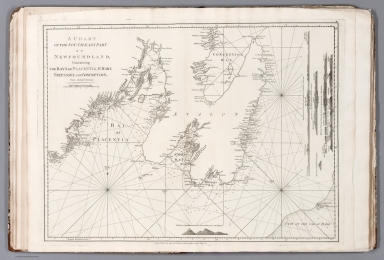
A chart of the south-east part of Newfoundland, containing the Bays of Placentia, St. Mary, Trepassey and Conception. From actual surveys. London. Printed for R. Sayer & J. Bennett, at No. 53 in Fleet Street. 10 May 1770.
List No
14400.007
Note
Nautical chart of the southeast area of Newfoundland, including the Bays of Placentia, Saint Mary, Trepassey and Conception, in 1770. Shows cities, topography, bodies of water, drainage, bays, ports, anchorage, shoals, rocks and depths, given in fathoms. Relief shown with hachures. Includes rhumb lines, latitudinal and longitudinal lines, as well as a bar scale and compass rose with north oriented toward top of sheet. Descriptive notes throughout. With profile views: Appearance of Cape Mutton bearing N.E. 5 leagues with the land to the eastward ... Black and white copper-engraving. Chart is 49 x 67 cm, on double plate 57 x 76 cm.
Author
Cook, James, active 1762-1775
Full Title
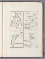
Trinity Harbour -- St. John's Harbour -- Carboniere and Harbour Grace. Printed for R. Sayer & J. Bennett, No. 53 in Fleet Street. 10 May 1770.
List No
14400.008
Note
Three nautical charts of Trinity Harbour, St. John's Harbour, Carboniere and Harbour Grace, Newfoundland, in 1770. Charts show cities, fortifications, topography, bodies of water, drainage, bays, ports, anchorage, shoals, rocks and depths, given in fathoms. Relief shown with hachures. Includes rhumb lines, bar scales (scales differ) and compass roses with north oriented toward top of sheet. Black and white copper-engraving. Together, charts are 36 x 29 cm, on plate 57 x 36 cm.
Author
Cook, James, active 1762-1775
Full Title
The Harbour of Trepassey with Mutton and Biscay Bays -- The road and Harbour of Placentia. By James Cook -- St. Mary's Harbour. Printed for R. Sayer & J. Bennett, No. 53 in Fleet Street. 10 May 1770. J. Jeffreys sculp.
List No
14400.009
Note
Three nautical charts of Trepassey Bay, Mutton Bay, Biscay Bay, Placentia Bay and Saint Mary's Bay, Newfoundland, in 1770. Charts show cities, topography, bodies of water, drainage, bays, ports, anchorage, shoals, rocks and depths, given in fathoms. Relief shown with hachures. Includes rhumb lines, bar scales (scales differ) and compass roses with north oriented toward top of sheet. Black and white copper-engraving. Together, charts are 34 x 29 cm, on plate 57 x 37 cm.
Author
Cook, James, active 1762-1775
Full Title
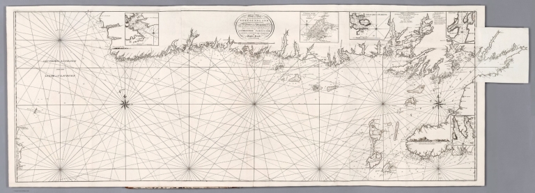
Chart of part of the south coast of Newfoundland including the Islands of Langley, St. Peters and Miquelon with the southern entrance into the Gulph of St. Laurence from actual surveys taken by order of Commodore Pallisser, Governor of Newfoundland, Labradore, &c. By James Cook, Surveyor. Published by permission, of the Right Honble. the Lords Commissioners of the Admiralty by James Cook. Printed for R. Sayer and J. Bennett, at No. 53 in Fleet Street. 10 May 1774.
List No
14400.010
Note
Nautical chart of the south coast of Newfoundland, including the islands of Langley [Greening's Island], Saint Peter's and Miquelon, in 1774. Shows cities, topography, bodies of water, drainage, bays, ports, anchorage, shoals, rocks and depths, given in fathoms. Relief shown with hachures. Includes rhumb lines, latitudinal and longitudinal lines, as well as a bar scale and compass rose with north oriented toward top of sheet. Descriptive notes throughout. With inset charts: Port Aux Basque -- St. Peters Island survey'd by Engineer Fortin in 1763 -- Great Jervis Harbour -- Harbour Briton -- Harbour of St. Laurence. Also with profile view: A view of C. Chapeaurouge or the Mountain of the Red Hat, taken at the Point A in the chart. Black and white copper-engraving. Chart is 64 x 193 cm, on fold-out plate 68 x 197 cm. References listed at upper right.
Author
Cook, James, active 1762-1775
Full Title
A new map of Nova Scotia and Cape Breton Island with the adjacent parts of New England and Canada, composed from a great number of actual surveys; and other materials regulated by many new astronomical observations of the longitude as well as latitude; by Thomas Jeffreys, Geographer to the King. London. Published according to Act of Parliament by Thos. Jeffreys, Geographer to the King. London. Printed & sold by R. Sayer and J. Bennett; No. 53, in Fleet Street.
List No
14400.011
Note
Nautical chart of Nova Scotia and Cape Breton Island, circa 1774. Shows cities, fortifications, topography, bodies of water, drainage, bays, ports, anchorage, shoals, rocks and depths, given in fathoms. Relief shown pictorially. Includes rhumb lines, latitudinal and longitudinal lines, as well as two bar scales. Descriptive notes throughout. With table: Observations on which this map is grounded. Decorative cartouche. Black and white copper-engraving. Chart is 47 x 61 cm, on double plate 57 x 76 cm. (Date inferred based upon preceding map.)
Author
Cook, James, active 1762-1775
Full Title
The Island of Sable lies in latitude 44.6 N. and longitude 60.26 west from London. Printed for R. Sayer and J. Bennett, No. 53 in Fleet Street. Published as the Act directs. 10 May 1770. J. Jeffreys sculp.
List No
14400.012
Note
Nautical chart of Sable Island, Nova Scotia, in 1770. Shows cities, topography, bodies of water, drainage, ports, anchorage, shoals, shipwrecks and depths, given in fathoms. Relief shown pictorially. Includes rhumb lines, as well as a compass rose with north oriented toward top of sheet. Descriptive notes throughout, and beneath map. Black and white copper-engraving. Chart is 21 x 37 cm, on plate 37 x 57 cm.
Author
Cook, James, active 1762-1775
Full Title
A chart of the Harbour of Halifax, in Nova Scotia; with Jebucto Bay and Cape Sambrô, also the islands, ledges of rocks, shoals & soundings. Survey'd by Order of His Excellency Brigadier General Lawrence, Governour of the Province of Nova Scotia; by Charles Morris, Chief Surveyor. Published by Command of the Right Honourable the Lords of Trade & Plantations, for the Benefit of the Trade and Navigation of Great Britain and its colonies. London. Engraved by Thomas Jeffreys, Geography to the King. London. Printed for & sold by Robt. Sayer and Jno. Bennett, No. 53 in Fleet Street, as the Act directs. 25th March 1775.
List No
14400.013
Note
Nautical chart of Halifax Harbour, Jebucto Bay [Chedabucto Bay], and Cape Sambrô, Nova Scotia, in 1775. Shows cities, topography, bodies of water, drainage, ports, anchorage, shoals, rocks and depths, given in fathoms. Relief shown pictorially. Includes rhumb lines, as well as a bar scale and compass roses with north oriented toward right side of sheet. Descriptive notes throughout, and above map. Black and white copper-engraving. Chart is 40 x 60 cm, on double plate 57 x 76 cm.
Author
Cook, James, active 1762-1775
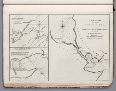
Full Title
A plan of Port Dauphin, on the eastern side of Cape Breton Island, surveyed in 1743 -- A plan of Murgain of Cow Bay, on the eastern side of Cape Breton Island, surveyed in August 1760 -- A draught of the Gut of Canso, between Nova Scotia and Cape Breton Island, surveyed by the King's Ships in 1761.
List No
14400.014
Note
Three nautical charts of Port Dauphin and Murgain (or Cow Bay), Cape Breton Island, as well as the Strait of Canso between Nova Scotia and Cape Breton Island, in 1743, 1760 and 1761, respectively. Charts show cities, topography, bodies of water, drainage, bays, ports, anchorage, shoals and depths, given in fathoms. Relief shown with hachures. Includes rhumb lines, bar scales (scales differ) and compass rose with north oriented toward top of sheet. Black and white copper-engraving. Together, charts are 34 x 51 cm, on plate 37 x 57 cm.
Author
Cook, James, active 1762-1775
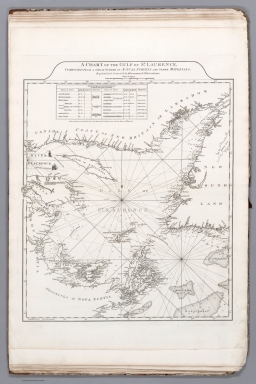
Full Title
A chart of the Gulf of St. Laurence, composed from a great number of actual surveys and other materials, regulated and corrected by astronomical observations. London. Printed for & sold by Robt. Sayer and Jno. Bennett, No. 53 in Fleet Street, as the Act directs. 25th March 1775.
List No
14400.015
Note
Nautical chart of the Gulf of Saint Lawrence, in 1775. Shows cities, topography, bodies of water, drainage, ports, anchorage, shoals, rocks and depths, given in fathoms. Features routes of voyages. Relief shown pictorially. Includes rhumb lines, latitudinal and longitudinal lines, as well as a bar scale and compass rose with north oriented toward top of sheet. Descriptive notes throughout. With table: Astronomical observations on which this chart is grounded. Black and white copper-engraving. Chart is 56 x 49 cm, on double plate 76 x 57 cm.
Author
Cook, James, active 1762-1775
Full Title
A chart of the Magdalen Islands in the Gulf of St. Laurence surveyed in 1765. J. Jeffreys sculp.
List No
14400.016
Note
Nautical chart of the Magdalen Islands in the Gulf of Saint Lawrence, in 1765. Shows cities, topography, bodies of water, drainage, ports, anchorage, shoals, rocks and depths, given in fathoms. Relief shown with hachures. Includes a legend, rhumb lines, latitudinal and longitudinal lines, as well as a bar scale and compass rose with north oriented toward top of sheet. Map indexed, with key beneath title. Black and white copper-engraving. Chart is 27 x 35 cm, on plate 37 x 57 cm.
Author
Cook, James, active 1762-1775
Full Title
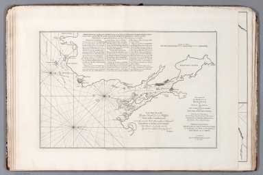
A map of the Island of St. John in the Gulf of St. Laurence divided into counties & parishes and the lots, as granted by government, to which are added the soundings round the coast & harbours, improv'd from the late Survey of Captain Holland. Published as the Act direct April 6, 1774.
List No
14400.017
Note
Nautical chart of Saint John Island in the Gulf of Saint Lawrence, in 1774. Shows cities, property divisions, topography, vegetation, bodies of water, drainage, ports, anchorage, shoals, rocks and depths, given in fathoms. Relief shown with hachures. Includes rhumb lines, a bar scale and compass rose with north oriented toward top-left of sheet. With inset chart: [Gulf of St. Laurence]. Also, with two tables: The contents of the respective divisions of the Island of St. John -- A list of lots and proprietors names. Black and white copper-engraving. Chart is 36 x 69 cm, on double plate 57 x 76 cm.
Author
Cook, James, active 1762-1775
Full Title
A plan of Chaleur Bay in the Gulf of St. Laurence, surveyed by His Majesty's Ship Norwich in 1760. London. Printed for & sold by Robt. Sayer & Jno. Bennett, No. 53 in Fleet Street, as the Act directs, 25th, March 1775.
List No
14400.018
Note
Nautical chart of Chaleur Bay in the Gulf of Saint Lawrence, in 1760. Shows cities, topography, bodies of water, drainage, ports, anchorage, shoals, rocks and depths, given in fathoms. Relief shown pictorially. Includes rhumb lines, a bar scale and compass rose with north oriented toward top of sheet. Descriptive notes throughout. Black and white copper-engraving. Chart is 34 x 54 cm, on plate 37 x 57 cm.
Author
Cook, James, active 1762-1775
Full Title
A plan of Ristigouche Harbour in Chaleur Bay, surveyed in 1760, by the Kings Ship Norwich. London. Printed for & sold by Robt. Sayer & Jno. Bennett No. 53 in Fleet Street as the Act directs, 25th, March 1775.
List No
14400.019
Note
Nautical chart of Ristigouche Harbour in Chaleur Bay in the Gulf of Saint Lawrence, in 1760. Shows cities, topography, bodies of water, drainage, ports, anchorage, shoals, rocks and depths, given in fathoms. Relief shown pictorially. Includes rhumb lines, a bar scale and compass rose with north oriented toward top of sheet. Descriptive notes throughout, and beneath map. Black and white copper-engraving. Chart is 34 x 52 cm, on plate 37 x 57 cm.
Author
Cook, James, active 1762-1775
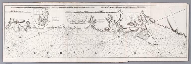
Full Title
A chart of the west coast of Newfoundland, surveyed by Order of Commodore Pallisser, Governor of Newfoundland, Labradore &c. &c. By James Cook, Surveyor. London. Published by permission, of the Right Honble. the Lords Commissioners of the Admiralty. By James Cook, and sold with a Book of Directions. Printed for R. Sayer & J. Bennett, No. 53 in Fleet Street, 10 May 1770.
List No
14400.020
Note
Nautical chart of the west coast of Newfoundland, in 1770. Shows cities, topography, bodies of water, drainage, ports, anchorage, shoals, rocks and depths, given in fathoms. Relief shown pictorially. Includes a legend, rhumb lines, a bar scale and compass roses with north oriented toward lower-left of sheet. With two inset charts: A plan of Hawkes Harbour, Port Saunders and Keppee Harbour -- A plan of York and Lark Harbours, in the Bay of Islands. Also, with five profile views: A view of the land between Point Ferolle and Point Rich, taken at the Vessel A, in the Chart ... The perspective point of each view is indicated by the locations of ships throughout the chart. Black and white copper-engraving. Chart is 49 x 172 cm, on fold-out plate 57 x 176 cm.
|