|
Author
[Faden, William, 1749-1836, Delarochette, L. (Louis), 1731-1802]
Full Title
The coast of Guyana from the Oroonoko to the River of Amazons and the inland parts as far as they have been explored by the French & Dutch engineers with the Islands of Barbadoes, Tobago &ca. from the observations of Captain Edward Thompson made in the Hyæna, in the year 1781, when he commanded in the Rivers Berbice, Essequebo and Demerari, and governed those colonies after their conquest from the Dutch. By L. S. de la Rochette, MDCCLXXXIII. London. Engraved & published by Willm. Faden, Geographer to the King, Charing-Cross, Octor. 6th. 1783.
List No
14383.060
Note
Nautical chart of the Guyanan Coast, from the Oroonoko River to the Amazon River, as of 1783. Shows political boundaries, cities, ports, topography, bodies of water, drainage, coastlines, islands, sand banks and depths. Relief shown pictorially. Includes latitudinal and longitudinal lines, as well as rhumb lines, a compass roses with north oriented toward top of sheet, and arrows indicating the direction of water flow. Decorative cartouche. With four inset maps: Entrance of River Berbice -- Surinam River, from the Dutch -- Port of Cayenne, from the French -- The entrances of the Rivers Essequebo and Demerari. With two profile views: The entrance of Demerari River -- Appearance of the land about Cayenne. Hand-colored engraving. Map is 50 x 64 cm, on double sheet 50 x 55 cm. With stamp: Liverpool Library.
Author
Arrowsmith, Aaron
Full Title
Letter from Aaron Arrowsmith to John Pinkerton dated May 10, 1803
List No
15935.001
Author
Arrowsmith, Aaron
Full Title
(Verso) Letter from Aaron Arrowsmith to John Pinkerton dated May 10, 1803
List No
15935.002
Author
Arrowsmith, Aaron
Full Title
(Address) Letter from Aaron Arrowsmith to John Pinkerton dated May 10, 1803
List No
15935.003
Author
Carleton, Osgood
Full Title
A New Map of the United States, of America Including part of Louisiana. Drawn from the latest Authorities. Revised and corrected by Osgood Carleton Esq. Teacher of Mathematics, Boston. Boston, Published and Sold by John Sullivan, Junr. 1806.
List No
5801.000
Note
Osgood Carleton first published a map of the United States in 1791. Another edition appeared in 1797, and then this edition in 1806. This issue is a major redrawing of the 1791 and 1797 maps, and it borrows heavily from Arrowsmith's Map of the United States, 1802 (see our list no. 5699.009, from Thompson's Alcedo Atlas, our 5699.000) especially in the west. But Carleton uses other sources as well, including Bradley's postal map. There was another issue of this map, undated, and updated to some unknown period, perhaps after 1810 or even later (Chris Lane, Philadelphia Print Shop).
Author
[Oddy, S.A., Wallis, James]
Full Title
West Indies. London, Published by S.A. Oddy, No. 20 Warwick Lane. Engraved by Jas. Wallis.
List No
2972.025
Author
[Alcedo, Antonio de, 1735-1812, Arrowsmith, Aaron, Thompson, George Alexander]
Full Title
(Covers to) Atlas to Thompson's Alcedo; or dictionary of America & West Indies; collated with all the most recent authorities, and composed chiefly from scarce and original documents, for that work, by A. Arrowsmith, Hydrographer to His Royal Highness the Prince Regent. London: Printed by George Smeeton, Great Saint Martin's Lane, Charing Cross. 1819.
List No
5699A
Author
[Alcedo, Antonio de, 1735-1812, Arrowsmith, Aaron, Thompson, George Alexander]
Full Title
(Index to) Atlas to Thompson's Alcedo; or dictionary of America & West Indies; collated with all the most recent authorities, and composed chiefly from scarce and original documents, for that work, by A. Arrowsmith, Hydrographer to His Royal Highness the Prince Regent. London: Printed by George Smeeton, Great Saint Martin's Lane, Charing Cross. 1819.
List No
5699B
Note
Diagram showing the arrangement of the 19 sheets comprising the five maps. "Atlas to Thompson's Alcedo; or dictionary of America and West Indies by Arrowsmith. Index."
Author
[Alcedo, Antonio de, 1735-1812, Arrowsmith, Aaron, Thompson, George Alexander]
Full Title
(Title Page to) Atlas to Thompson's Alcedo; or dictionary of America & West Indies; collated with all the most recent authorities, and composed chiefly from scarce and original documents, for that work, by A. Arrowsmith, Hydrographer to His Royal Highness the Prince Regent. London: Printed by George Smeeton, Great Saint Martin's Lane, Charing Cross. 1819.
List No
5699C
Author
Arrowsmith, Aaron
Full Title
A map exhibiting all the new discoveries in the interior parts of North America, inscribed by permission to the Honorable Governor and Company of Adventurers of England trading into Hudson Bay, in testimony of their liberal communications to their most obedient and very humble servant, A. Arrowsmith, Hydrographer to H.R.H. the Prince of Wales. (Sheet 1). No. 10 Soho Square. January 1st, 1795 -- additions to 1811, 1818.
List No
5699.001
Note
Engraved map. Hand col. Relief shown by hachures. Sheet 1 of 3. Shows settlements, Indian tribes, rivers, etc. In lower margin: London, Published 1 Jan. 1795 by A. Arrowsmith ... additions to 1802. Below title: Additions to June 1814. Printed on 2 sheets, joined together.
Author
Arrowsmith, Aaron
Full Title
(A map exhibiting all the new discoveries in the interior parts of North America, inscribed by permission to the Honorable Governor and Company of Adventurers of England trading into Hudson Bay, in testimony of their liberal communications to their most obedient and very humble servant, A. Arrowsmith, Hydrographer to H.R.H. the Prince of Wales. Sheet 2.) London: Published Jan. 1, 1795 by A. Arrowsmith, No. 10 Soho Square -- additions to 1802. (1818)
List No
5699.002
Note
Engraved map. Hand col. Relief shown by hachures. Sheet 2 of 3. Shows settlements, Indian tribes, rivers, etc. Printed on 2 sheets, joined together.
Author
Arrowsmith, Aaron
Full Title
(A map exhibiting all the new discoveries in the interior parts of North America, inscribed by permission to the Honorable Governor and Company of Adventurers of England trading into Hudson Bay, in testimony of their liberal communications to their most obedient and very humble servant, A. Arrowsmith, Hydrographer to H.R.H. the Prince of Wales. Sheet 3.) London: Published 1 Jan. 1795 by A. Arrowsmith, No. 10 Soho Square -- additions to 1802. (1818)
List No
5699.003
Note
Engraved map. Hand col. Relief shown by hachures. Sheet 3 of 3. Shows settlements, Indian tribes, rivers, etc. Printed on 2 sheets, joined together.
Author
Arrowsmith, Aaron
Full Title
(Composite of) A map exhibiting all the new discoveries in the interior parts of North America, inscribed by permission to the Honorable Governor and Company of Adventurers of England trading into Hudson Bay, in testimony of their liberal communications to their most obedient and very humble servant, A. Arrowsmith, Hydrographer to H.R.H. the Prince of Wales. No. 10 Soho Square. January 1st, 1795 -- additions to 1811, 1818.
List No
5699.004
Note
Engraved map on 3 sheets. Hand col. Relief shown by hachures. Shows settlements, Indian tribes, rivers, etc. In lower margin: London, Published 1 Jan. 1795 by A. Arrowsmith ... additions to 1802. Below title: Additions to June 1814. Printed on 6 sheets, joined together as 3.
Author
Arrowsmith, Aaron
Full Title
A map of the United States of North America. Drawn from a number of critical researches by A. Arrowsmith, Hydrographer to H.R.H. the Prince of Wales. (Sheet 1). No. 10 Soho Square. London, Published as the Act directs by A. Arrowsmith, no. 10 Soho Square -- Jan. 1st, 1796, additions to 1802.
List No
5699.005
Note
Engraved map. Outline hand col. Relief shown by pictorially and by hachures. Sheet 1 of 4. Shows settlements, roads with distances, Indian tribes, rivers, etc. Title in cartouche with large illustration of "Falls of Niagara" that includes text.
Author
Arrowsmith, Aaron
Full Title
(A map of the United States of North America. Drawn from a number of critical researches by A. Arrowsmith, Hydrographer to H.R.H. the Prince of Wales. Sheet 2). London, Published as the Act directs by A. Arrowsmith, no. 10 Soho Square -- Jan. 1st, 1796, additions to 1802.
List No
5699.006
Note
Engraved map. Outline hand col. Relief shown by pictorially and by hachures. Sheet 2 of 4. Shows settlements, roads with distances, Indian tribes, rivers, etc.
Author
Arrowsmith, Aaron
Full Title
(A map of the United States of North America. Drawn from a number of critical researches by A. Arrowsmith, Hydrographer to H.R.H. the Prince of Wales. Sheet 3). London, Published as the Act directs by A. Arrowsmith, no. 10 Soho Square. (1802).
List No
5699.007
Note
Engraved map. Outline hand col. Relief shown by pictorially and by hachures. Sheet 3 of 4. Shows settlements, roads with distances, Indian tribes, rivers, etc.
Author
Arrowsmith, Aaron
Full Title
(A map of the United States of North America. Drawn from a number of critical researches by A. Arrowsmith, Hydrographer to H.R.H. the Prince of Wales. Sheet 4). London, Published as the Act directs by A. Arrowsmith, no. 10 Soho Square -- Jan. 1st, 1796, additions to 1802.
List No
5699.008
Note
Engraved map. Outline hand col. Relief shown by pictorially and by hachures. Sheet 3 of 4. Shows settlements, roads with distances, Indian tribes, rivers, etc.
Author
Arrowsmith, Aaron
Full Title
(Composite of) A map of the United States of North America. Drawn from a number of critical researches by A. Arrowsmith, Hydrographer to H.R.H. the Prince of Wales. No. 10 Soho Square. London, Published as the Act directs by A. Arrowsmith, no. 10 Soho Square -- Jan. 1st, 1796, additions to 1802.
List No
5699.009
Note
Engraved map on 4 sheets. Outline hand col. Relief shown by pictorially and by hachures. Shows settlements, roads with distances, Indian tribes, rivers, etc. Title in cartouche with large illustration of "Falls of Niagara" that includes text.
Author
[Arrowsmith, Aaron, Humboldt, Alexander von, 1769-1859]
Full Title
A new map of Mexico and adjacent provinces compiled from original documents by A. Arrowsmith, 1810. (Sheet 1). (with) Valley of Mexico, from Mr. Humboldt's map. London, Published 5th October 1810 by A. Arrowsmith, 10 Soho Squ(ar)e, Hydrographer to H.R.H. the Prince of Wales. Engraved by E. Jones.
List No
5699.010
Note
Engraved map. Outline hand col. Relief shown by hachures. Sheet 1 of 4. Shows settlements, roads, Indian tribes, rivers, etc. Scale of inset (ca. 1:363,000)
Author
[Arrowsmith, Aaron, Humboldt, Alexander von, 1769-1859]
Full Title
(A new map of Mexico and adjacent provinces compiled from original documents by A. Arrowsmith, 1810. Sheet 2). (with) Veracruz. (with) Acapulco. London, Published 5th October 1810 by A. Arrowsmith, 10 Soho Square. (Engraved by E. Jones)
List No
5699.011
Note
Engraved map. Outline hand col. Relief shown by hachures. Sheet 2 of 4. Shows settlements, roads, Indian tribes, rivers, etc.
Author
[Arrowsmith, Aaron, Humboldt, Alexander von, 1769-1859]
Full Title
(A new map of Mexico and adjacent provinces compiled from original documents by A. Arrowsmith, 1810. Sheet 3). London, Published 5th October 1810 by A. Arrowsmith, 10 Soho Square. (Engraved by E. Jones)
List No
5699.012
Note
Engraved map. Outline hand col. Relief shown by hachures. Sheet 3 of 4. Shows settlements, roads, Indian tribes, rivers, etc. Covers "New Albion" and parts of the Southwest.
Author
[Arrowsmith, Aaron, Humboldt, Alexander von, 1769-1859]
Full Title
(A new map of Mexico and adjacent provinces compiled from original documents by A. Arrowsmith, 1810. Sheet 4). London, Published 5th October 1810 by A. Arrowsmith, 10 Soho Square. (Engraved by E. Jones)
List No
5699.013
Note
Engraved map. Outline hand col. Relief shown by hachures. Sheet 4 of 4. Shows settlements, roads, Indian tribes, rivers, etc. Covers parts of the Southwestern U.S.
Author
[Arrowsmith, Aaron, Humboldt, Alexander von, 1769-1859]
Full Title
(Composite of) A new map of Mexico and adjacent provinces compiled from original documents by A. Arrowsmith, 1810. (with) Valley of Mexico, from Mr. Humboldt's map. (with) Veracruz. (with) Acapulco. London, Published 5th October 1810 by A. Arrowsmith, 10 Soho Square, Hydrographer to H.R.H. the Prince of Wales. Engraved by E. Jones.
List No
5699.014
Note
Engraved map on 4 sheets. Outline hand col. Relief shown by hachures. Shows settlements, roads, Indian tribes, rivers, etc. Scale of Valley of Mexico inset (ca. 1:363,000)
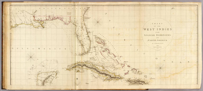
Author
Arrowsmith, Aaron
Full Title
Chart of the West Indies and Spanish Dominions in North America. (Sheet 1). By A. Arrowsmith. 1803. Hydrographer to H.R.H. the Prince of Wales. Additions to 1810. London, Published June 1st, 1803 by A. Arrowsmith, 10 Soho Square. Jones, Smith & Co. sc., Beaufort Buildgs., Strand.
List No
5699.015
Note
Engraved map. Outline hand col. Relief shown by hachures; depths by soundings. Sheet 1 of 2. Shows settlements, roads, rivers, etc. Includes descriptive notes. Printed on 2 sheets, joined together.
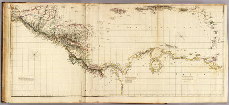
Author
Arrowsmith, Aaron
Full Title
(Chart of the West Indies and Spanish Dominions in North America. Sheet 2. By A. Arrowsmith. 1803. Hydrographer to H.R.H. the Prince of Wales. Additions to 1810). London, Published June 1st, 1803 by A. Arrowsmith, 10 Soho Square. (Jones, Smith & Co. sc., Beaufort Buildgs., Strand)
List No
5699.016
Note
Engraved map. Outline hand col. Relief shown by hachures; depths by soundings. Sheet 2 of 2. Shows settlements, roads, rivers, etc. Includes descriptive notes. Printed on 2 sheets, joined together.
Author
Arrowsmith, Aaron
Full Title
(Composite of) Chart of the West Indies and Spanish Dominions in North America. By A. Arrowsmith. 1803. Hydrographer to H.R.H. the Prince of Wales. Additions to 1810. London, Published June 1st, 1803 by A. Arrowsmith, 10 Soho Square. Jones, Smith & Co. sc., Beaufort Buildgs., Strand.
List No
5699.017
Note
Engraved map. Outline hand col. Relief shown by hachures; depths by soundings. Shows settlements, roads, rivers, etc. Includes descriptive notes. Printed on 4 sheets, mounted as 2.
Author
Arrowsmith, Aaron
Full Title
Outlines of the physical and political divisions of South America: (Sheet 1) delineated by A. Arrowsmith, partly from scarce and original documents, published before the year 1806 but principally from manuscript maps & surveys made between the years 1771 and 1806, corrected from accurate astronomical observations to 1810. London, Published 4th January 1811 by A. Arrowsmith, No. 10 Soho Square, Hydrographer to H.R. H. the Prince of Wales. Additions to 1814, 1817. Engraved by Edwd. Jones.
List No
5699.018
Note
Engraved map. Outline hand col. Relief shown by hachures. Sheet 1 of 6. Shows settlements, roads, rivers, Indian tribes, etc.
Author
Arrowsmith, Aaron
Full Title
(Outlines of the physical and political divisions of South America: Sheet 2. Delineated by A. Arrowsmith, partly from scarce and original documents, published before the year 1806 but principally from manuscript maps & surveys made between the years 1771 and 1806, corrected from accurate astronomical observations to 1810) London, Published 4th January 1811 by A. Arrowsmith, No. 10 Soho Square, (Hydrographer to H.R. H. the Prince of Wales. Additions to 1814, 1817. Engraved by Edwd. Jones)
List No
5699.019
Note
Engraved map. Outline hand col. Relief shown by hachures. Sheet 2 of 6. Shows settlements, roads, rivers, Indian tribes, etc.
Author
Arrowsmith, Aaron
Full Title
(Outlines of the physical and political divisions of South America: Sheet 3. Delineated by A. Arrowsmith, partly from scarce and original documents, published before the year 1806 but principally from manuscript maps & surveys made between the years 1771 and 1806, corrected from accurate astronomical observations to 1810) London, Published 4th January 1811 by A. Arrowsmith, No. 10 Soho Square, (Hydrographer to H.R. H. the Prince of Wales. Additions to 1814, 1817. Engraved by Edwd. Jones)
List No
5699.020
Note
Engraved map. Outline hand col. Relief shown by hachures. Sheet 3 of 6. Shows settlements, roads, rivers, Indian tribes, etc.
Author
Arrowsmith, Aaron
Full Title
(Outlines of the physical and political divisions of South America: Sheet 4. Delineated by A. Arrowsmith, partly from scarce and original documents, published before the year 1806 but principally from manuscript maps & surveys made between the years 1771 and 1806, corrected from accurate astronomical observations to 1810) London, Published 4th January 1811 by A. Arrowsmith, No. 10 Soho Square, (Hydrographer to H.R. H. the Prince of Wales. Additions to 1814, 1817. Engraved by Edwd. Jones)
List No
5699.021
Note
Engraved map. Outline hand col. Relief shown by hachures. Sheet 4 of 6. Shows settlements, roads, rivers, Indian tribes, etc.
Author
Arrowsmith, Aaron
Full Title
(Outlines of the physical and political divisions of South America: Sheet 5. Delineated by A. Arrowsmith, partly from scarce and original documents, published before the year 1806 but principally from manuscript maps & surveys made between the years 1771 and 1806, corrected from accurate astronomical observations to 1810) (with Inset map of the Orinoco and Meta rivers). London, Published 4th January 1811 by A. Arrowsmith, No. 10 Soho Square, (Hydrographer to H.R. H. the Prince of Wales. Additions to 1814, 1817. Engraved by Edwd. Jones)
List No
5699.022
Note
Engraved map. Outline hand col. Relief shown by hachures. Sheet 5 of 6. Shows settlements, roads, rivers, Indian tribes, etc. Scale of inset (ca. 1:118,000)
Author
Arrowsmith, Aaron
Full Title
(Outlines of the physical and political divisions of South America: Sheet 6. Delineated by A. Arrowsmith, partly from scarce and original documents, published before the year 1806 but principally from manuscript maps & surveys made between the years 1771 and 1806, corrected from accurate astronomical observations to 1810). London, Published 4th January 1811 by A. Arrowsmith, No. 10 Soho Square, (Hydrographer to H.R. H. the Prince of Wales. Additions to 1814, 1817. Engraved by Edwd. Jones)
List No
5699.023
Note
Engraved map. Outline hand col. Relief shown by hachures. Sheet 6 of 6. Shows settlements, roads, rivers, Indian tribes, etc. Patagonia, Tierra del Fuego and the Falkland Islands are in inset map.
Author
Arrowsmith, Aaron
Full Title
(Composite of) Outlines of the physical and political divisions of South America: delineated by A. Arrowsmith, partly from scarce and original documents, published before the year 1806 but principally from manuscript maps & surveys made between the years 1771 and 1806, corrected from accurate astronomical observations to 1810. (with Inset map of the Orinoco and Meta rivers). London, Published 4th January 1811 by A. Arrowsmith, No. 10 Soho Square, Hydrographer to H.R. H. the Prince of Wales. Additions to 1814, 1817. Engraved by Edwd. Jones.
List No
5699.024
Note
Engraved map. Outline hand col. Relief shown by hachures. Shows settlements, roads, rivers, Indian tribes, etc.
Author
[Burr, David H., 1803-1875, Colton, J. H.]
Full Title
Texas, By David H. Burr. Published by J.H. Colton & Co. New-York. 1835 Engraved by S. Stiles & Co. N. York. Entered ... 1833, by J.H. Colton & Co. ... New York. (inset) Plan of the Port of Galveston, Made by order of the Mexican Government, By Alexander Thompson, Of the Mexican Navy, in 1828.
List No
5024.001
Note
This is the third edition of this scarce and important map of Texas. The first edition was issued in 1833 and the second edition in 1834. Streeter also lists an 1845 edition with the title changed to "The State of Texas." This copy was Streeter's copy with his notes on the inside front cover. The brown cloth covers 13.5x8 have "Burr's Map Of The State of Coha. & Texas Published By J.H. Colton & Co. New York" stamped in gilt. Full color. Streeter refers to this map as "the first large scale map of Texas... to show all of Texas to the Arkansas River" and states that "The Burr map, like the Austin Map, is one of the landmarks of Texas cartography..." The detail on the land grants is the best for its time. The 1833 issue shows a smaller Texas extending west to the 103rd meridian, whereas the 1834 and 1835 issues show a much expanded Texas extending west to about the 106th meridian and north to the Arkansas River. There is an inset map of Galveston Bay that Streeter refers to in his penciled notes on the inside cover as "1st detailed printed chart of Galveston Bay?" Above the inset map is a table of Distances. Yale has an 1835 edition that was issued earlier in the year than this copy - it does not show Milan's Grant in place of Beal's Grant and it does not list the four new towns that appear on our 1835 edition: Columbia, Electa, Mina and Augusta. Taliaferro 247 (illustrated) appears to be the same as Yale's copy.
Author
Smiley, Thomas T.
Full Title
Western States. (with) inset map of Upper Michigan.
List No
0902.007
Note
In full color by state. Vignette of an Indian hunter.
Author
[Breese, Samuel, 1802-1873, Morse, Sidney E. (Sidney Edwards), 1794-1871]
Full Title
Connecticut. (By Sidney E. Morse and Samuel Breese. New York: Published by Harper & Brothers, 1845)
List No
2301.008
Note
Col. wax engraved map. Relief shown by hachures. Prime meridians: Greenwich and Washington.
Author
Campbell, Albert
Full Title
(Title Page to) Report upon the Pacific Wagon Roads, constructed Under the direction of the Hon. Jacob Thompson, Secretary of the Interior, in 1857-'58-'59. By Albert H. Campbell, General Superintendent, &c. Department of the Interior, Pacific Wagon Road Office, February 19, 1859.
List No
1582A
Author
[U.S. War Department, Weyss, John E.]
Full Title
Harper's Ferry. Prepared by Bvt. Brig. Gen N. Michler, Major of Engineers from Surveys under his direction By Order of Brig. Genl. & Bvt. Maj. Genl. A.A. Humphreys, Chief of Engineers and under the Authority of the Hon. Secretary of War. 1867. Surveyed & drawn by Maj: J.E. Weyss, assisted by F. Theilkuhl, J. Strasser & G. Thompson. Photolith. by the N.Y. Lithographing, Engraving & Printing Co., Julius Bien, Supt.
List No
3881.016
Note
Full printed color.
Author
Thompson and Everts
Full Title
Map of West Point Township.
List No
4459.017
Author
Everts, Baskin and Stewart
Full Title
(View) Res. of Lewis Kretsinger. Res. of R.T. Jones. Res. of Chas. B. Reber. Res. of M.J.West. Res. of Israel Alden. Res. of Jacob Piper of Daniel.
List No
3206.032
Author
Thompson Bro's & Burr
Full Title
(View) Residence of John McCowan. (Portrait) W.R. Scott, the Popular Sewing Machine Man of the North West.
List No
5088.094
Author
Thompson Bro's & Burr
Full Title
Map of Reed Township, Town 32, Range 9 East. West Fraction of Wesley Township, T 32 N. R 9 E.
List No
5088.152
Note
Includes a brief history of the township, and crop statistics.
Author
Andreas, A. T. (Alfred Theodore), 1839-1900
Full Title
(Portraits of) Physicians: J.P. Waste, J.R.M. Gaskill, E.H. Lewis, Wm. W. Sweney, J.H. Murphy, A.E. Ames, J.E. Tebbets, L.S. Thompson, O.H. Hall, C. Carli, W.R. McMahan, S. Watkins, J.E. Finch, Absalom B. Stuart, D.W. Hand, W.W. Mayo, T.R. Potts, James M. Cole, Franklin Staples, L.A. Kelly, Chr. Gronvold, Martin Hagan. (Published by A.T. Andreas, Lakeside Building, Chicago, 1874. Chas. Shober & Co. Proprietors of Chicago Lith. Co.)
List No
3034.175
Note
Twenty-two lithographed views.
Author
Andreas, A. T. (Alfred Theodore), 1839-1900
Full Title
(Portraits of) Early settlers: H.G. McCaleb, Geo. Healy, Thomas Brooks, F.T. Olds, E. Daman, J.V. Daniels, W.L. Brackenridge, John R. Cook, E.C. Cross, M.D., A.C. Smith, R. Cornforth, Capt. A. Harkins, Samuel Eaton, William Holmes, Fred Smithson, Oscar G. Wall, Geo. Baihly, J.D. Blake. Farmers: H. Thompson, T. Carlos Jewett, John M. Bayard, Geo. B. Dresbach. (Published by A.T. Andreas, Lakeside Building, Chicago, 1874. Chas. Shober & Co. Proprietors of Chicago Lith. Co.)
List No
3034.182
Note
Twenty-two lithographed views.
Author
Andreas, A. T. (Alfred Theodore), 1839-1900
Full Title
"Cherry Grove" stock farm, D.H. Van Pelt, proprietor ... Washington Tp. ... (with) "Hillside Farm," residence of N.M. Thompson ... Greenfield Tp. ... (with) Home of B.F. Wadsworth ... Allen Tp. ... (all) Warren Co., Iowa. Views in seventh congressional district, State of Iowa. Chas. Shober & Co., props., Chicago Lith. Co. (Published by the Andreas Atlas Co., Lakeside Building, Chicago, Ills. Engraved & printed by Chas. Shober & Co., Props. of Chicago Lithographing Co.)
List No
0018.147
Note
Three lithographed views.
Author
Hamel, P.W.
Full Title
Plan and section of cave in Cave Valley, Southeastern Nevada. Surveyed by P.W. Hamel, 1869. Drawn by Weyss & Thompson. The Graphic Co., N.Y. (1889)
List No
2220.001
Note
Lithographed map, sepia toned. Relief shown by hachures. Vertical scale of plan ca. 1:1,589.
Full Title
Crossing of the Colorado River near mouth of Paria Creek. Eastern edge of the Grand Canon in the distance. (Sketched by Gilbert Thompson). 1873. U.S. Geographical Surveys West of the 100th Meridian. (1889)
List No
2220.008
Note
Lithographed view, sepia toned. Shows Indian overlooking canyons.
Author
[Hamel, P.W., Nell, Louis, Wheeler, G.M.]
Full Title
Map showing routes of the river and land parties engaged in exploring the Grand Canon of the Colorado. Under the command of 1st. Lieut. Geo. M. Wheeler, Corps of Engineers, U.S. Army. 1871. P.W. Hamel and L. Nell, topographers. Issued Feb. 4th 1878. The Graphic Co. Photo-Lith., 30 & 41 Park Place, N.Y. Weyss, Thompson & Lang del. By order of the Honorable the Secretary of War. Under the direction of Brig. Gen. A.A. Humphreys, Chief of Engineers, U.S. Army. (in upper margin:) United States Geographical Surveys West of the 100th Meridian. (1889)
List No
2220.025
Note
Lithographed map, sepia toned. Relief shown by hachures and spot heights. Shows drainage, roads, surveyors' routes & campsites, etc. Prime meridians: Washington and Greenwich.
Author
[United States. Army. Corps of Engineers, Wheeler, G.M.]
Full Title
Topographical sketch showing observatory site and surroundings at Ogden, Utah. Surveyed 1877. Prepared under the direction of 1st Lt. Geo. M. Wheeler, Corps of Engs., U.S. Army. Surveyed by Thompson & Weyss. Weyss & Lang del. The Graphic Co., N.Y. U.S. Geographical Surveys West of the 100th Meridian. By order of the honorable the Secretary of War, under the direction of Brig. Gen. A.A. Humphreys, Chief of Engineers U.S. Army. (1877)
List No
2220.043
Note
Lithographed map, sepia toned. Relief shown by hachures and spot heights. Shows fields, lots, buildings, and streets with names, etc. Includes profile.
Full Title
Apparatus for determining absolute personal equation. G. Thompson, del. The Graphic Co., N.Y. (1877)
List No
2220.044
Note
Sepia tone lithographed drawing of astronomical observation instruments.
|