COLLECTION NAME:
David Rumsey Historical Map Collection
Record
Author:
Cook, James
Date:
1773
Short Title:
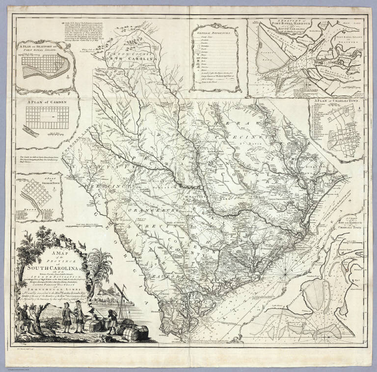
A Map of the Province of South Carolina.
Publisher:
No Publisher
Publisher Location:
London
Type:
Separate Map
Obj Height cm:
76
Obj Width cm:
81
Scale 1:
586,080
Note:
The maker of this map, James Cook, surveyor of South Carolina and former marine surveyor, is not to be confused with the Pacific explorer, Captain James Cook. In 1770, James Cook was commissioned by the South Carolina provincial government to make a new survey of the entire province and publish a map, which he completed in 1773. Cummings refers to the map as "the most detailed and accurate printed map of South Carolina, especially for the interior, yet to appear" and further states that "very few copies of this fine map are extant." It provided much of the detail for the later maps by Henry Mouzon and John Stuart. Sellers and Van Ee call it "one of the most important maps in the cartography of the state until the early nineteenth century." It is excessively rare, with only five copies identified in United States institutions, and one in the British Museum. There are two states of this first and only issue, distinguished by the presence in the second state of an additional imprint "Publish'd according to Act of Parliament July 7th. 1773 and Sold by H. Parker in Cornhill" under the neat line. This copy is the first state, with two of the other six copies being first state as well. There are six inset maps: Beaufort, Camden, Georgetown, Port Royal, Charles Town, and Harbour of Charles Town. The main map is very detailed, showing land owners in profusion. Along the coast are many navigation notes, indicative of Cook's maritime background. This appears to have been Cook's only major map production; his other work is limited to three harbor charts published in 1766 (illustrated by Black): A Draught of Port Royal Harbour (similar to the Port Royal inset map on the South Carolina 1773), A Draught of the Harbour of Halifax, and A Draught of West Florida.
Reference:
Cummings 443 (illustrated plate 67) and p 59; Sellers and Van Ee 1521; J.D. Black, Map Collector 34, p. 10-15; Cumming, British Maps of Colonial America p.47-48; Tooley Dictionary p. 130 (South Carolina map misdated 1770).
State/Province:
South Carolina
Full Title:
A Map of the Province of South Carolina with all the Rivers, Creeks, Bays, Inletts, Islands, Inland Navigation, Soundings, Time of High Water on the Sea Coast, Roads, Marshes, Ferrys, Bridges, Swamps, Parishes Churches, Towns, Townships; Country Parish District and Provincial Lines. Humbly inscribed to the Hon.ble Lawlins Lownds Esqr. Speaker & the rest of the Members of the Hon.ble the Commons House of Assembly of the Province by their most Obedt. & faithfull Servt Jams Cook. Thos. Bowen, sculpt. 1773. (with 6 inset maps).
List No:
5174.000
Series No:
1
Publication Author:
Cook, James
Pub Date:
1773
Pub Title:
A Map of the Province of South Carolina with all the Rivers, Creeks, Bays, Inletts, Islands, Inland Navigation, Soundings, Time of High Water on the Sea Coast, Roads, Marshes, Ferrys, Bridges, Swamps, Parishes Churches, Towns, Townships; Country Parish District and Provincial Lines. Humbly inscribed to the Hon.ble Lawlins Lownds Esqr. Speaker & the rest of the Members of the Hon.ble the Commons House of Assembly of the Province by their most Obedt. & faithfull Servt Jams Cook. Thos. Bowen, sculpt. 1773. (with 6 inset maps).
Pub Reference:
Cummings 443 (illustrated plate 67) and p 59; Sellers and Van Ee 1521; J.D. Black, Map Collector 34, p. 10-15; Cumming, British Maps of Colonial America p.47-48; Tooley Dictionary p. 130 (South Carolina map misdated 1770).
Pub Note:
See note field above.
Pub List No:
5174.000
Pub Type:
Separate Map
Pub Maps:
1
Pub Height cm:
76
Pub Width cm:
81
Image No:
5174000
Authors:
Cook, James
Collection:
Rumsey Collection
