COLLECTION NAME:
David Rumsey Historical Map Collection
Record
Author:
Desilver, Charles
Author:
Richardson, W. & D.
Date:
1861
Short Title:
Richardson's New Map Of The State Of Texas.
Publisher:
Charles Desilver
Publisher Location:
Philadelphia
Type:
Separate Map
Obj Height cm:
63
Obj Width cm:
83
Scale 1:
1:2,300,000
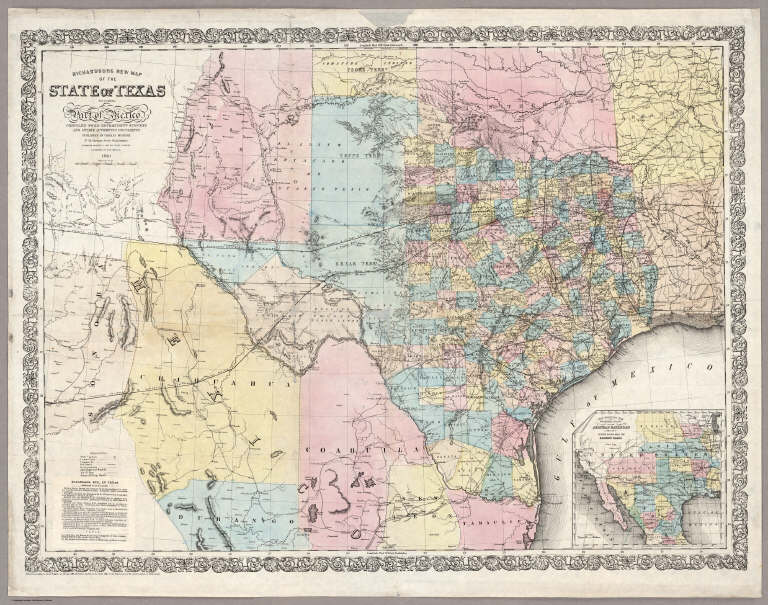
Note:
This is an exceptionally attractive map of Texas on the eve of the Civil War. It was issued with Richardson's Texas Almanac of 1861 or possibly the 1862 issue (almanac not present). Railroads completed and in progress are particularly well delineated, and a box of text in the lower left corner (pasted on top of an earlier printing) lists the completed railroads and their proposed extensions as well as one canal, the Galveston Bay and Brazos River. In the lower right is an inset map of the proposed route of the Arkansas Railroad. The topography, coasts and rivers are accurately delineated, with the source being the outstanding Map of Texas and part of Mexico, 1857, issued by the Bureau of Topographical Engineers (see our #5141). Pressler's Map of the State of Texas, 1858, is a secondary source, as is J.H. Young's Map of the State of Texas which was published in Desilver's 1859 (Mitchell's) New Universal Atlas (see our #4557). Richardson's map is a serious production, far more up to date than the Colton, Johnson, or Desilver/Mitchell atlas maps of 1861, and more accurate in west Texas, southern New Mexico and northern Mexico than the Pressler 1858 Texas (although Pressler issued an 1862 revised edition, not seen by us, that may be much improved). The first issue of Richardson's map appeared in the 1859 edition of the Texas Almanac, with the map dated 1859, copyright 1858 (Winkler 1052); again in the 1860 Almanac, with the map dated 1860; and our copy, dated 1861 and presumably appearing in the 1861 Almanac (Rosenberg 322B states that the Almanacs for 1857, and 1862-65 did not contain maps). Two other maps appeared in the Richardson Almanacs: J.H. Young's Map of the State of Texas (from Desilver's atlas) in the 1858 Almanac (Winkler 886 note) and Richardson's New Map of Texas, published by G.W. and C.B. Colton (Day 428 - about the same size as the Colton atlas map of 1867 and possibly related) and issued in the 1867 Almanac. Desilver stopped map publishing ar
Reference:
Rosenberg Library 322A, 322B; Day 1012 (1860 edition) and 428; Winkler 1373x; P-Maps 846.
State/Province:
Texas
Full Title:
Richardson's New Map Of The State Of Texas Including Part of Mexico Compiled From Government Surveys And Other Authentic Documents. Published By Charles Desilver No. 714 Chestnut Street Philadelphia. Engraved Expressly For The Texas Almanac. Corrected By H. Wickland. 1861. Entered ... 1861 by Charles Desilver ... Pennsylvania. (inset) Map Showing The Proposed Route Of The Aransas (sic) Railroad (And Its) Connections With The Eastern Roads.
List No:
5178.000
Series No:
1
Engraver or Printer:
Wickland, H.
Publication Author:
Desilver, Charles
Publication Author:
Richardson, W. & D.
Pub Date:
1861
Pub Title:
Richardson's New Map Of The State Of Texas Including Part of Mexico Compiled From Government Surveys And Other Authentic Documents. Published By Charles Desilver No. 714 Chestnut Street Philadelphia. Engraved Expressly For The Texas Almanac. Corrected By H. Wickland. 1861. Entered ... 1861 by Charles Desilver ... Pennsylvania. (inset) Map Showing The Proposed Route Of The Aransas (sic) Railroad (And Its) Connections With The Eastern Roads.
Pub Reference:
Rosenberg Library 322A, 322B; Day 1012 (1860 edition) and 428; Winkler 1373x; P-Maps 846.
Pub Note:
This is an exceptionally attractive map of Texas on the eve of the Civil War. It was issued with Richardson's Texas Almanac of 1861 or possibly the 1862 issue (almanac not present). Railroads completed and in progress are particularly well delineated, and a box of text in the lower left corner (pasted on top of an earlier printing) lists the completed railroads and their proposed extensions as well as one canal, the Galveston Bay and Brazos River. In the lower right is an inset map of the proposed route of the Arkansas Railroad. The topography, coasts and rivers are accurately delineated, with the source being the outstanding Map of Texas and part of Mexico, 1857, issued by the Bureau of Topographical Engineers (see my #5141). Pressler's Map of the State of Texas, 1858, is a secondary source, as is J.H. Young's Map of the State of Texas which was published in Desilver's 1859 (Mitchell's) New Universal Atlas (see my #4557). Richardson's map is a serious production, far more up to date than the Colton, Johnson, or Desilver/Mitchell atlas maps of 1861, and more accurate in west Texas, southern New Mexico and northern Mexico than the Pressler 1858 Texas (although Pressler issued an 1862 revised edition, not seen by me, that may be much improved). The first issue of Richardson's map appeared in the 1859 edition of the Texas Almanac, with the map dated 1859, copyright 1858 (Winkler 1052); again in the 1860 Almanac, with the map dated 1860; and my copy, dated 1861 and presumably appearing in the 1861 Almanac (Rosenberg 322B states that the Almanacs for 1857, and 1862-65 did not contain maps). Two other maps appeared in the Richardson Almanacs: J.H. Young's Map of the State of Texas (from Desilver's atlas) in the 1858 Almanac (Winkler 886 note) and Richardson's New Map of Texas, published by G.W. and C.B. Colton (Day 428 - about the same size as the Colton atlas map of 1867 and possibly related) and issued in the 1867 Almanac. Desilver stopped map publishing aroun
Pub List No:
5178.000
Pub Type:
Separate Map
Pub Maps:
1
Pub Height cm:
63
Pub Width cm:
83
Image No:
5178000
Authors:
Desilver, Charles; Richardson, W. & D.
Collection:
Rumsey Collection
Richardson's New Map Of The State Of Texas.