COLLECTION NAME:
David Rumsey Historical Map Collection
Record
Author:
Tanner, Henry S.
Date:
1846
Short Title:
Map Of The United States Of Mexico.
Publisher:
H.S. Tanner
Publisher Location:
Philadelphia
Type:
Pocket Map
Obj Height cm:
58
Obj Width cm:
72
Scale 1:
5,195,520
Note:
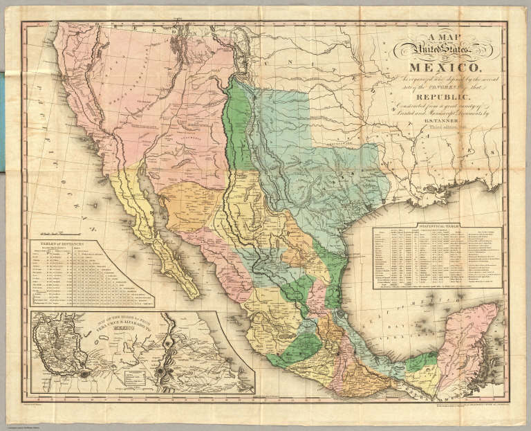
3rd edition. Martin shows 10 issues 1825-47. 1st edition was 1825 (see W.H. copy). The 1826 edition of this map (see our copy) was the base for the White, Gallaher & White "Mapa de los Estados Unidos de Mejico" of 1828, which was then copied by Disturnell in 1846 (see our copy). Originally, Tanner copied this map from the southwestern portion of his Map of North America. This 1846 edition has updated the western cartography to include Fremont's route and topography in California and the Rocky Mountains. Interestingly, Lake Tahoe is labeled Flag Lake, a name we have never seen before. The 1826 edition of this map established the more northerly boundary of New Mexico and Mexico that White Gallaher & White copied and was ultimately used by Disturnell in his map, and affected the treaty negotiations (see Martin). See our 1847, fifth edition, #5158. Full color map, folded into dark brown cloth covers 15x9.5 with "Tanner's Travelling Map Of Mexico" stamped in gilt.
Reference:
Martin/Ristow p207-8 (A la Carte).
Country:
Mexico
State/Province:
California
State/Province:
Texas
Event:
Mexican U.S. War
Event:
Mexican U.S. War
Full Title:
A Map Of The United States Of Mexico, As organized and defined by the several Acts of the Congress of that Republic. Constructed from a great variety of Printed and Manuscript Documents by H.S. Tanner. Third Edition, 1846. Published by H.S. Tanner. Entered ... 1846, by H.S. Tanner ... New York. (inset) Map Of The Roads &c. From Vera Cruz & Alvarado To Mexico.
List No:
2822.001
Series No:
2
Publication Author:
Tanner, Henry S.
Pub Date:
1846
Pub Title:
A Map Of The United States Of Mexico, As organized and defined by the several Acts of the Congress of that Republic. Constructed from a great variety of Printed and Manuscript Documents by H.S. Tanner. Third Edition, 1846. Published by H.S. Tanner. Entered ... 1846, by H.S. Tanner ... New York. (inset) Map Of The Roads &c. From Vera Cruz & Alvarado To Mexico.
Pub Reference:
Martin/Ristow p207-8 (A la Carte).
Pub Note:
See note field above.
Pub List No:
2822.000
Pub Type:
Pocket Map
Pub Maps:
1
Pub Height cm:
58
Pub Width cm:
72
Image No:
2822001
Authors:
Tanner, Henry S.
Collection:
Rumsey Collection