COLLECTION NAME:
David Rumsey Historical Map Collection
Record
Author:
Thompson, Thos. H.
Date:
1892
Short Title:
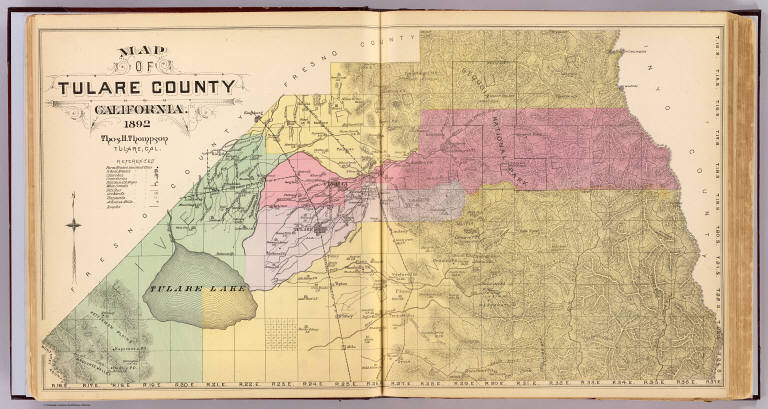
Tulare County, California.
Publisher:
T.H. Thompson
Publisher Location:
Tulare
Type:
Atlas Map
Obj Height cm:
37
Obj Width cm:
69
Scale 1:
302,000
Note:
Hand col. lithograph. Relief shown by hachures. Shows townships and sections, Indian reservation, Sequoia National Park, schools, railroad, Tulare Lake, etc. In 1893 Kings County was formed from a part of Tulare County.
State/Province:
California
County:
Kings County (Calif.)
County:
Tulare County (Calif.)
Subject:
U.S. Public Survey
Full Title:
Map of Tulare County, California. 1892. Thos. H. Thompson, Tulare, Cal.
List No:
2211.003
Page No:
(29-30)
Series No:
7
Publication Author:
Thompson, Thos. H.
Pub Date:
1892
Pub Title:
Official historical atlas map of Tulare County ... compiled, drawn and published from personal examinations and surveys by Thos. H. Thompson, Tulare, California. 1892.
Pub Reference:
Phillips, 11497; LeGear. Atlases of the United States, L 481; Rocq, M.M. California local history, 15171.
Pub Note:
See note field above.
Pub List No:
2211.000
Pub Type:
County Atlas
Pub Maps:
111
Pub Height cm:
40
Pub Width cm:
37
Image No:
2211003
Authors:
Thompson, Thos. H.
Collection:
Rumsey Collection