COLLECTION NAME:
David Rumsey Historical Map Collection
Record
Author:
L'Isle, Guillaume de, 1675-1726
Date:
1708
Short Title:
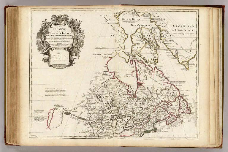
Canada, Nouvelle France.
Publisher:
Guillaume De L'Isle, Quai de l'Horloge a l'Aigle d'Or
Publisher Location:
Paris
Type:
Atlas Map
Obj Height cm:
50
Obj Width cm:
65
Scale 1:
9,000,000
Note:
Engraved map in outline color. Shows forested areas. Relief shown pictorially. Covers eastern Canada and the United States south to 39 degrees N. Fourth state, with imprint of L. Renard Libraire and name of cartouche engraver N. Guerard erased from engraving plate. Reproduced in the "Labrador Boundary Canadian Atlas." Incorporates Lahontan's imaginary features including the Pays des Gnacsitares and the Riviere Morte.
Reference:
Kershaw, Early Printed Maps of Canada, 311; Tooley, Mapping of America, 37; P-Maps, p. 189; Wheat, 85; Paullin and Wright, pl. 23A.
World Area:
North America
Country:
Canada
Country:
United States
Full Title:
Carte du Canada ou de la Nouvelle France et des decouvertes que y ont ete faites. Dressee sur plusieurs observations et sur un grand nombre de relations imprimees ou manuscrites. Par Guillaume Del'Isle, Geographe de l'Academie Royale des Sciences. A Paris, chez l'Auteur sur le Quai de l'Horloge al Aigle d'Or, avec Privilege du sa Maj. pour 20 ans, 1703 (between 1708 and 1712?).
List No:
4764.097
Page No:
88
Series No:
98
Publication Author:
L'Isle, Guillaume de, 1675-1726
Pub Date:
1731
Pub Title:
(Atlas de Geographie)
Pub Reference:
cf P533, 535; Tooley, Mapping of America p.1-28.; Martin & Martin, 14 & 19; Wheat 99; Cumming 170.
Pub Note:
De L'Isle is important as the first "scientific" cartographer who incorporated the most current information on exploration and topography into his maps. His maps of America contain many innovations: discarding the fallacy of California as an island, first naming of Texas, first correct delineation of the Mississippi Valley, and first correct longitudes of America. Lloyd Brown states that De L'Isle "undertook a complete reform of a system of geography that had been in force since the second century, and by the time he was twenty five he had very nearly accomplished his purpose." This copy is without title page, as issued. This is a relatively early edition of De L'Isle's untitled atlas, published in Paris, with most of the maps having the "Quai de l'Horloge" imprint. All of the important maps of the Americas are present: Hemisphere Occidental, 1st issue 1724; Carte d'Amerique, 1st issue, 2nd state 1722; L'Amerique Septentrionale, 2nd issue 1700-1708 ; L'Amerique Meridionale, 3rd issue 1700-1708; Carte du Canada, 2nd issue 1703-1708; Carte de la Louisiane, 1st issue, 2nd state with New Orleans 1718; Carte du Mexique et de la Floride, 2nd issue 1703-1708; Carte de l'Isle de Saint Dominque, 1st issue 1725; Carte des Antilles, 1st issue 1717; Carte de la Terre Ferme du Peru, du Brazil, 2nd issue 1703-1708; and Carte du Paraguay du Chili, 2nd issue 1703-1708. Only two of the ninety four maps were issued after De l'Isle's death in 1826: "Carte du... Senegal... Ouvrage Posthume... Par... La Veuve Delisle 1826" and "Alexandri Magni Imperium...Opus Posthumum...1731." Early Paris editions (ie before Buache became publisher in 1732) of De L'Isle's atlas with the full 94 maps are scarce - the LOC has none.
Pub List No:
4764.000
Pub Type:
World Atlas
Pub Maps:
94
Pub Height cm:
55
Pub Width cm:
40
Image No:
4764097
Authors:
L'Isle, Guillaume de, 1675-1726
Collection:
Rumsey Collection