COLLECTION NAME:
David Rumsey Historical Map Collection
Record
Author:
Dunn, Samuel
Date:
1787
Short Title:
A general map of the world or terraqueous globe.
Publisher:
Robert Sayer
Publisher Location:
London
Type:
Atlas Map
Obj Height cm:
52
Obj Width cm:
123
Scale 1:
41,000,000
Note:
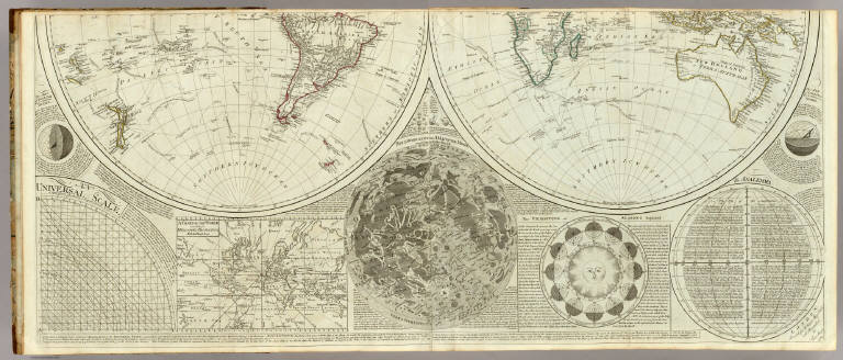
Engraved map on 2 sheets (comprising the southern half of the 4-sheet map ). Continent boundaries in outline color. Shows explorers' tracks. Relief shown pictorially. Includes ancillary maps, charts and drawings of "A chart of the world according to Mercator's projection with the Rhumb lines," "Selenography or a map of the Moon according to Father Riccioli," "The vicissitude of seasons explained," "The Analemma," two drawings entitled "The art of dialing by a common globe," "A Universal scale," and text. David Rumsey Collection copy has the 2 sheets mounted together.
Reference:
P4300.
World Area:
World
Subject:
Celestial
Full Title:
(A general map of the world or terraqueous globe; with all the new discoveries and marginal delineations, containing the most interesting particulars in the solar, starry and mundane systems. By Saml. Dunn, Mathematician). London: printed for Rt. Sayer, Map, Chart and Printseller, 53 Fleet Street, 1787.
List No:
0411.002
Page No:
2
Series No:
4
Publication Author:
Kitchin, Thomas
Pub Date:
1790
Pub Title:
A general atlas, describing the whole universe: being a complete collection of the most approved maps extant; corrected with the greatest care, and augmented from the latest discoveries. The whole being an improvement of the maps of D'Anville and Robert. Engraved in the best manner on sixty-two copper-plates, by Thomas Kitchin, Senior, and Others. London: printed For Robert Sayer, no. 53, Fleet-Street, (1790).
Pub Reference:
P4300.
Pub Note:
Late issue. Many of the maps are double sheet. This atlas was later expanded to become the New Universal Atlas (see David Rumsey Collection copy). Some of these maps also appeared in the American Atlas by Jefferys. There are actually 23 large maps, on 35 connected sheets, produced from 62 copper plates. Maps are hand painted with outline and full color and bound in half leather tan marbled paper covered boards with "General Atlas" stamped in gold on the spine. Inscription inside front cover in pen-and-ink: R. Sayer pub, 53 Fleet ... 8th, 1791 ...
Pub List No:
0411.000
Pub Type:
World Atlas
Pub Maps:
35
Pub Height cm:
55
Pub Width cm:
41
Image No:
0411002
Authors:
Dunn, Samuel
Collection:
Rumsey Collection