COLLECTION NAME:
David Rumsey Historical Map Collection
Record
Author:
Kitchin, Thomas
Date:
1788
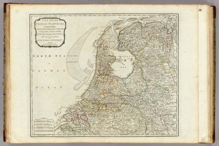
Short Title:
The Seven United Provinces.
Publisher:
Robert Sayer
Publisher Location:
London
Type:
Atlas Map
Obj Height cm:
48
Obj Width cm:
58
Scale 1:
560,000
Note:
Engraved map. Shows forested areas, morasses, roads, etc. Counties and duchies in outline color. Relief shown pictorially. (E 2 30--E 7 08/N 53 34--N 51 13)
Reference:
P4300.
Country:
Netherlands
Full Title:
The Seven United Provinces, comprehending Holland, Zeeland, Utrecht, Gelders, Over-Yssel, Frieseland and Groningen; with the Land of Drent; also Dutch Flanders and Dutch Brabant. London, printed for Robert Sayer, Fleet Street and published as the Act directs April 10th 1788.
List No:
0411.018
Page No:
13
Series No:
20
Publication Author:
Kitchin, Thomas
Pub Date:
1790
Pub Title:
A general atlas, describing the whole universe: being a complete collection of the most approved maps extant; corrected with the greatest care, and augmented from the latest discoveries. The whole being an improvement of the maps of D'Anville and Robert. Engraved in the best manner on sixty-two copper-plates, by Thomas Kitchin, Senior, and Others. London: printed For Robert Sayer, no. 53, Fleet-Street, (1790).
Pub Reference:
P4300.
Pub Note:
Late issue. Many of the maps are double sheet. This atlas was later expanded to become the New Universal Atlas (see David Rumsey Collection copy). Some of these maps also appeared in the American Atlas by Jefferys. There are actually 23 large maps, on 35 connected sheets, produced from 62 copper plates. Maps are hand painted with outline and full color and bound in half leather tan marbled paper covered boards with "General Atlas" stamped in gold on the spine. Inscription inside front cover in pen-and-ink: R. Sayer pub, 53 Fleet ... 8th, 1791 ...
Pub List No:
0411.000
Pub Type:
World Atlas
Pub Maps:
35
Pub Height cm:
55
Pub Width cm:
41
Image No:
0411018
Authors:
Kitchin, Thomas
Collection:
Rumsey Collection