
|
|
|
Coast of California showing San Andreas Rift. California. State Earthquake Investigation Commission, 1908
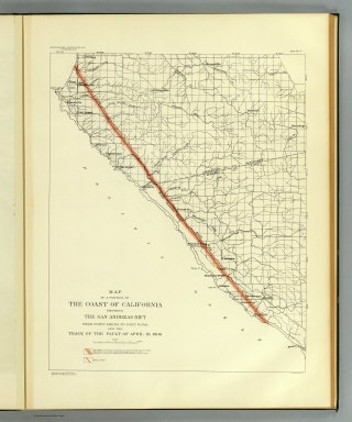 View larger, zoomable image (turn off pop-up blocker) Full Title: Map of a portion of the coast of California showing the San Andreas Rift from Point Arena to Fort Ross and the trace of the fault of April 18, 1906. Earthquake Investigation Commission. Julius Bien & Co., N.Y. (Carnegie Institution of Washington. 1908) Author: California. State Earthquake Investigation Commission Date: 1908 This historical cartographic image is part of the David Rumsey Historical Map Collection, www.davidrumsey.com, a large collection of online antique, rare, old, and historical maps, atlases, globes, charts, and other cartographic items. Read more about the Collection. Or you can view the entire David Rumsey Map Collection in Insight. Full David Rumsey Map Collection Catalog Record: Author: California. State Earthquake Investigation Commission Date: 1908 Short Title: Coast of California showing San Andreas Rift. Publisher: Washington: Carnegie Institution Type: Atlas Map Object Height cm: 51 Object Width cm: 40 Scale 1: 140,000 Note: Color. Also shows settlements, townships and sections, roads and drainage. "Compiled from the official maps of Sonoma and Mendocino Counties." State / Province: California County: Mendocino County (Calif.) ; Sonoma County (Calif.) Subject: Physical ; Geology Full Title: Map of a portion of the coast of California showing the San Andreas Rift from Point Arena to Fort Ross and the trace of the fault of April 18, 1906. Earthquake Investigation Commission. Julius Bien & Co., N.Y. (Carnegie Institution of Washington. 1908) List No: 2130.002 Page No: map 2 Series No: 5 Engraver or Printer: Julius Bien & Co. Published In: Atlas of maps and seismograms accompanying the report of the State Earthquake Investigation Commission upon the California earthquake of April 18, 1906. Andrew C. Lawson, G.K. Gilbert, H.F. Reid, J.C. Branner, A.O. Leuschner, George Davidson, Charles Burckhalter, W.W. Campbell. Carnegie Institution of Washington. Washington, D.C. 1908. (seal) Carnegie Institution of Washington 1902. Publication Author: California. State Earthquake Investigation Commission; Lawson, Andrew C.; Reid, Harry Fielding; Gilbert, G. K.; Branner, John Casper Publication Date: 1908 Publication Reference: P3703; U.S. Atlases L452. Publication Note: See note field above. Publication List No: 2130.000 Publication Type: Physical Atlas Publication Maps: 25 Publication Height cm: 62 Publication Width cm: 49 Image No: 2130002
Important!
The Insight® Browser and Java client software are products of Luna Imaging, Inc. If you have comments, suggestions, or need help, contact The David Rumsey Collection at home | about | view the
collection | recent
additions | news | help |
