
|
|
|
Colton's New Railroad & County Map Of The United States. Colton, J.H. 1862
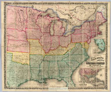 View larger, zoomable image (turn off pop-up blocker) Full Title: Colton's New Railroad & County Map Of The United States, The Canadas &c. Published By J.H. Colton, No. 172 William St., New York 1862. Entered ... 1861 by J.H. Colton ... New York. (inset) Colton's Map of the United States Showing the Proposed Railroad Routes To The Pacific Ocean. (inset) Southern Part Of Florida. Author: Colton, J.H. Date: 1862 This historical cartographic image is part of the David Rumsey Historical Map Collection, www.davidrumsey.com, a large collection of online antique, rare, old, and historical maps, atlases, globes, charts, and other cartographic items. Read more about the Collection. Or you can view the entire David Rumsey Map Collection in Insight. Full David Rumsey Map Collection Catalog Record: Author: Colton, J.H. Date: 1862 Short Title: Colton's New Railroad & County Map Of The United States. Publisher: New York: J.H. Colton; London: Sampson Low, Son & Co. Type: Case Map Object Height cm: 84 Object Width cm: 99 Scale 1: 3,041,280 Note: Civil War map - Confederacy green, North red, border states yellow. A pasted down sheet in the bottom margin explains the color coding and gives population statistics for the three regions. There is an ad for "Colton's...Complete Series of War Maps" on the verso of the cover and a pasted down list of Union and Confederate Political and Military leaders on the verso of the map. The map was sold in London by Sampson Low, Son & Co., by arrangement with Colton. All the prices quoted for Colton's maps on the paste down are in pounds. There was great demand in England for maps of the American Civil War, and Colton exploited it by providing his maps to English map sellers. W.H. has an identical copy of this map sold by Crutchly. Stanford also sold this map under his imprint. Full color. Dissected into 32 sections. Folds into dark green cloth covers 23x14.5 with a green paper label reading "Colton's Map Of Thr (sic) The United States Of America And The Canadas." Reference: Stephenson 25.7. Country: United States ; Canada Event: U.S. Civil War Subject: Railroad Full Title: Colton's New Railroad & County Map Of The United States, The Canadas &c. Published By J.H. Colton, No. 172 William St., New York 1862. Entered ... 1861 by J.H. Colton ... New York. (inset) Colton's Map of the United States Showing the Proposed Railroad Routes To The Pacific Ocean. (inset) Southern Part Of Florida. List No: 3358.001 Series No: 2 Published In: Colton's New Railroad & County Map Of The United States, The Canadas &c. Published By J.H. Colton, No. 172 William St., New York 1862. Entered ... 1861 by J.H. Colton ... New York. (inset) Colton's Map of the United States Showing the Proposed Railroad Routes To The Pacific Ocean. (inset) Southern Part Of Florida. Publication Author: Colton, J.H. Publication Date: 1862 Publication Reference: Stephenson 25.7. Publication Note: See note field above. Publication List No: 3358.000 Publication Type: Case Map Publication Maps: 1 Publication Height cm: 23 Publication Width cm: 15 Image No: 3358001
Important!
The Insight® Browser and Java client software are products of Luna Imaging, Inc. If you have comments, suggestions, or need help, contact The David Rumsey Collection at home | about | view the
collection | recent
additions | news | help |
