
|
|
|
San Francisco Peninsula. United States Coast Survey, 1869
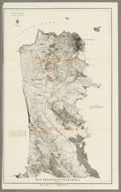 View larger, zoomable image (turn off pop-up blocker) Full Title: San Francisco Peninsula. U.S. Coast Survey. Benjamin Peirce, Superintendent. 1869. Price $1.50. Verified J.E. Hilgard. Assist Coast Survey. In Charge of Office. Author: United States Coast Survey Date: 1869 This historical cartographic image is part of the David Rumsey Historical Map Collection, www.davidrumsey.com, a large collection of online antique, rare, old, and historical maps, atlases, globes, charts, and other cartographic items. Read more about the Collection. Or you can view the entire David Rumsey Map Collection in Insight. Full David Rumsey Map Collection Catalog Record: Author: United States Coast Survey Date: 1869 Short Title: San Francisco Peninsula. Publisher: Washington: U.S. Type: Separate Map Object Height cm: 71 Object Width cm: 44 Scale 1: 40,000 Note: Heavy paper chart; uses contour lines. This is one of the first Coast Survey charts that we have seen that uses contour lines, other than the 1859 City of San Francisco and Its Vicinity (see our copy). Map without color. Published as map #14 in the "Report of the Superintendent of the United States Coast Survey, Showing the Progress of the Survey During the Year 1869." The report was finally published in 1872 and was the House of Representatives report from the 41st Congress, 2d Session, Ex. Doc. No. 206. Reference: None found. State / Province: California City: San Francisco (Calif.) Full Title: San Francisco Peninsula. U.S. Coast Survey. Benjamin Peirce, Superintendent. 1869. Price $1.50. Verified J.E. Hilgard. Assist Coast Survey. In Charge of Office. List No: 2648.000 Series No: 1 Published In: San Francisco Peninsula. U.S. Coast Survey. Benjamin Peirce, Superintendent. 1869. Price $1.50. Verified J.E. Hilgard. Assist Coast Survey. In Charge of Office. Publication Author: United States Coast Survey Publication Date: 1869 Publication Reference: None found. Publication Note: See note field above. Publication List No: 2648.000 Publication Type: Separate Map Publication Maps: 1 Publication Height cm: 71 Publication Width cm: 44 Image No: 2648000
Important!
The Insight® Browser and Java client software are products of Luna Imaging, Inc. If you have comments, suggestions, or need help, contact The David Rumsey Collection at home | about | view the
collection | recent
additions | news | help |
