 ERKELEY, Calif. -- FOR half a century, a
rare and extensive collection of historical Japanese maps
spanning hundreds of years have been stored in the East Asian
Library at the University of California, revealing their
secrets only to those few who had received permission to
handle them. Now, through state-of-the-art imaging technology,
anyone can view these fragile maps online, at www.davidrumsey.com/japan.
ERKELEY, Calif. -- FOR half a century, a
rare and extensive collection of historical Japanese maps
spanning hundreds of years have been stored in the East Asian
Library at the University of California, revealing their
secrets only to those few who had received permission to
handle them. Now, through state-of-the-art imaging technology,
anyone can view these fragile maps online, at www.davidrumsey.com/japan.
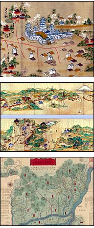
So far, 210 maps - some dating back almost 400 years - from
the 2,300-piece collection are online. The collection, which
will be available for viewing in its entirety within two
years, includes 252 maps of the city of Edo (now Tokyo), 79
maps of Kyoto and 40 maps of Osaka spanning the years 1600 to
1867. Many are woodblock prints on handmade paper. The
collection also includes a map from 1710 depicting the center
of the world as the source of four great rivers of India, and
a 40-foot scroll map of the roads of Japan in 1687.
|
Advertisement 
|
.gif) |
|
Visitors to the Web site can save the maps for their own
collections; analyze, rotate, enlarge and crop them; and
compare them with modern maps.
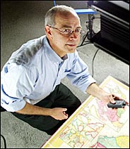
Peter Zhou, the director of the East Asian Library, said
the library had long wanted to digitize the map collection but
had lacked the money and the expertise to do so. "Because of
the complexity of the collection and the value of the
collection, we wanted to do it right," he said.
It turned out that the solution was just across the San
Francisco Bay. But Mr. Zhou found it circuitously, at a
cartographers' conference two years ago in Hong Kong. There he
met David Rumsey, an ardent map collector who had digitized
and cataloged his private collection of 150,000 maps at
www.davidrumsey.com.
Mr. Rumsey, president of Cartography Associates, a San
Francisco-based digital publisher of maps and art for Web
distribution, said he had seen the library's map collection
and "was tremendously impressed.''
"They say it's the largest collection of Japanese
historical cartography outside of Japan,'' he said. "So I
volunteered my services."
In 1997, Mr. Rumsey had faced a similar challenge when he
decided he wanted to open his collection of 19th- and
20th-century American maps and atlases to a wider audience
than the few hundred scholars and cartography buffs who had
visited him in San Francisco. "I'd been fairly close with the
Library of Congress and their digitization projects,
particularly in the maps arena," he said. He wanted a Web site
that could produce high-resolution images that would allow
viewers to feel as though they had a map in their hands.
"At the time, there were only two choices,'' he said. "One
was to develop my own thing, and that was looking like a long
road. And the other was when I discovered Luna Imaging."
Luna Imaging, based in Culver City, Calif., is known in the
museum and academic worlds for software that converts visual
material into high-resolution images that can be manipulated
at high speeds for research purposes. Founded in 1993 by
Michael Ester, a former director of the Getty Art History
Information Program, Luna met Mr. Rumsey's criteria for his
Web site so well that he embraced its software and joined the
company as a director in 1999.
"There's other software out there that will show an image,
but Luna has a very sophisticated and unique approach," Mr.
Rumsey said. "It stresses showing you the image. It lets the
image breathe. It doesn't surround the image with a lot of
text and frames and branding. It lets you compare images side
by side and lets you browse visually, by thumbnail or page
after page if you wanted. It also has a very sophisticated
searching technique."
To capture the best possible image, Mr. Rumsey built his
own scanning station, using a digital camera instead of a
traditional flatbed scanner to create greater depth of field.
The images are scanned at 300 pixels per inch.
Mr. Rumsey's Web site offers several options for viewing.
Visitors can download the Insight Java Client, available free
at the site. The software enables users to view maps in
detail, create and save groups of images, search for specific
maps and related images, including those at other Web sites.
"It's not just software, it's also a platform that multiple
collections can be viewed on," Mr. Rumsey said.
A customized Geographic Information Systems browser
developed by Telemorphic, a Web-based mapping developer in
Berkeley, can also be downloaded. It allows a user to compare
old maps with modern satellite views. If the user, for
instance, wants to analyze changes in Tokyo over the years,
the G.I.S. browser can overlay one map on top of another,
lining them up and even redrawing the old map to correlate
with the new one.
The browser provides three-dimensional views and
"fly-throughs," like zooming through the canyons of Yosemite
National Park in video-game fashion, although that option is
currently available only at Mr. Rumsey's Web site. The
application can allow four maps to be viewed
simultaneously.
"The digital images are even better than the originals
because you can amplify them, rotate them to look at them from
different angles," Mr. Zhou said. "In practical terms, this is
a better way of using the material than actually coming here
to see the pieces."
Mr. Rumsey said that the Internet had become a lifeline for
libraries in general. "Libraries and museums are going through
a very interesting period where they're beginning to make
their content available online," he said. "They have to
understand software and how it can work for
them."


 Western
States
Western
States New Jersey
Waterfront
New Jersey
Waterfront