
|
|
|
Orbis Romani, occidentalis. (Anville, Jean Baptiste Bourguignon d, 1697-1782; M'Dermut, Robert), 1814
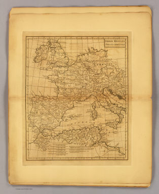 View larger, zoomable image (turn off pop-up blocker) Full Title: Orbis Romani pars occidentalis. Scoles sculp. (1814?) Author: (Anville, Jean Baptiste Bourguignon d, 1697-1782; M'Dermut, Robert) Date: 1814 This historical cartographic image is part of the David Rumsey Historical Map Collection, www.davidrumsey.com, a large collection of online antique, rare, old, and historical maps, atlases, globes, charts, and other cartographic items. Read more about the Collection. Or you can view the entire David Rumsey Map Collection in Insight. Full David Rumsey Map Collection Catalog Record: Author: (Anville, Jean Baptiste Bourguignon d, 1697-1782; M'Dermut, Robert) Date: 1814 Short Title: Orbis Romani, occidentalis. Publisher: New York: R. M'Dermut Type: Atlas Map Object Height cm: 26 Object Width cm: 22 Scale 1: 11,500,000 Note: Engraved map. Relief shown pictorially. Prime meridian: Ferro. World Area: Europe ; Africa Subject: Classical Full Title: Orbis Romani pars occidentalis. Scoles sculp. (1814?) List No: 3276.003 Page No: (3) Series No: 4 Engraver or Printer: Scoles, John, 1772?-1853 Published In: Atlas to the Ancient geography by M. D'Anville: containing ten maps ... New-York. Published By R. M'Dermut, No. 222 Pearl-street. (1814?) Publication Author: Anville, Jean Baptiste Bourguignon d, 1697-1782; M'Dermut, Robert Publication Date: 1814 Publication Reference: Cf P5587. Publication Note: See note field above. Publication List No: 3276.000 Publication Type: Classical Atlas Publication Maps: 10 Publication Height cm: 30 Publication Width cm: 20 Image No: 3276003
Important!
The Insight® Browser and Java client software are products of Luna Imaging, Inc. If you have comments, suggestions, or need help, contact The David Rumsey Collection at home | about | view the
collection | recent
additions | news | help |
