
|
|
|
Europe. (Cummings, J. A. (Jacob Abbot)), 1829
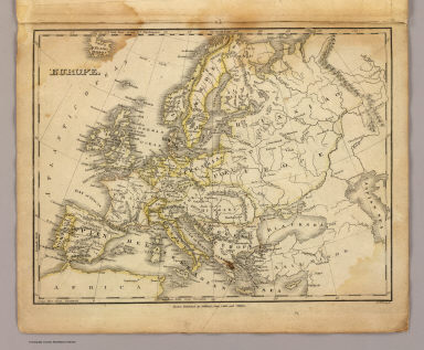 View larger, zoomable image (turn off pop-up blocker) Full Title: Europe. Boston, Published by Hilliard, Gray, Little and Wilkins. J.V.N. Throop Sc. (1829) Author: (Cummings, J. A. (Jacob Abbot)) Date: 1829 This historical cartographic image is part of the David Rumsey Historical Map Collection, www.davidrumsey.com, a large collection of online antique, rare, old, and historical maps, atlases, globes, charts, and other cartographic items. Read more about the Collection. Or you can view the entire David Rumsey Map Collection in Insight. Full David Rumsey Map Collection Catalog Record: Author: (Cummings, J. A. (Jacob Abbot)) Date: 1829 Short Title: Europe. Publisher: New York: Collins & Hannay Type: Atlas Map Object Height cm: 22 Object Width cm: 28 Scale 1: 20,000,000 Note: Engraved map. Outline hand color. Relief shown pictorially. Prime meridians: Washington and Greenwich. World Area: Europe Subject: School Full Title: Europe. Boston, Published by Hilliard, Gray, Little and Wilkins. J.V.N. Throop Sc. (1829) List No: 4493.007 Series No: 8 Engraver or Printer: Throop, J.V.N. Published In: School atlas to Cummings' ancient and modern geography improved. New-York: Published by Collins & Hannay. Sold by booksellers generally throughout the country. Treadwell's Power-Press. 1829. Publication Author: Cummings, J. A. (Jacob Abbot) Publication Date: 1829 Publication Note: See note field above. Publication List No: 4493.000 Publication Type: School Atlas Publication Maps: 9 Publication Height cm: 30 Publication Width cm: 24 Image No: 4493007
Important!
The Insight® Browser and Java client software are products of Luna Imaging, Inc. If you have comments, suggestions, or need help, contact The David Rumsey Collection at home | about | view the
collection | recent
additions | news | help |
