
|
|
|
Canal, Mississippi au Lac Pontchartrain. Poussin, Guillaume Tell, 1794-1876, 1834
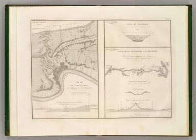 View larger, zoomable image (turn off pop-up blocker) Full Title: Plan du canal de jonction du Mississippi au Lac Pontchartrain. (with) Canal de Louisville. Profil moyen sur lequel a ete calcule de devis estimatif. (with) Canal de la Chesapeake a la Delaware. Plan du trace, situation des ecluses, nivellement general et profil du canal. Dessine par le Major Poussin. Grave par (V.?) Adam. (1834) Author: Poussin, Guillaume Tell, 1794-1876 Date: 1834 This historical cartographic image is part of the David Rumsey Historical Map Collection, www.davidrumsey.com, a large collection of online antique, rare, old, and historical maps, atlases, globes, charts, and other cartographic items. Read more about the Collection. Or you can view the entire David Rumsey Map Collection in Insight. Full David Rumsey Map Collection Catalog Record: Author: Poussin, Guillaume Tell, 1794-1876 Date: 1834 Short Title: Canal, Mississippi au Lac Pontchartrain. Publisher: Paris: Libraire Anselin; Paris: Libraire Carilian-Goeury Type: Atlas Map Object Height cm: 39 Object Width cm: 54 Scale 1: 50,000 Note: Engraved map with 2 insets. Soundings in English feet. State / Province: Louisiana ; Kentucky ; Delaware Subject: Canals Full Title: Plan du canal de jonction du Mississippi au Lac Pontchartrain. (with) Canal de Louisville. Profil moyen sur lequel a ete calcule de devis estimatif. (with) Canal de la Chesapeake a la Delaware. Plan du trace, situation des ecluses, nivellement general et profil du canal. Dessine par le Major Poussin. Grave par (V.?) Adam. (1834) List No: 2329.003 Page No: pl. III Series No: 7 Engraver or Printer: Imprimerie de Lachevardiere ; Adam, V. Published In: Travaux d'ameliorations interieures projetes ou executes par le Gouvernement General des Etats-Unis d'Amerique, de 1824 a 1831; par Guillaume-Tell Poussin ... Atlas. Paris, Anselin, Libraire, pour l'art militaire, les sciences et les arts, rue Dauphine, No. 36, dans le passage Dauphine. Carilian-Goeury, Libraire, des ponts et chaussees et des mines, Quai des Augustins, No. 41. 1834. Imprimerie de Lachevardiere, rue du Colombier, No. 30. Publication Author: Poussin, Guillaume Tell, 1794-1876 Publication Date: 1834 Publication Reference: Phillips 1265. Publication Note: Atlas only. Exceptionally well done maps that show the ambitious public works projects of the time. Maps are without color and bound in quarter leather green textured paper covered boards with "Poussin. Travaux d'amelioration En Amerique. Atlas" stamped in gilt on the spine. Publication List No: 2329.000 Publication Type: National Atlas Publication Maps: 10 Publication Height cm: 51 Publication Width cm: 36 Image No: 2329003
Important!
The Insight® Browser and Java client software are products of Luna Imaging, Inc. If you have comments, suggestions, or need help, contact The David Rumsey Collection at home | about | view the
collection | recent
additions | news | help |
