
|
|
|
California, Oregon, Washington, Utah, New Mexico. (Mitchell, Samuel Augustus), 1854
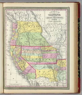 View larger, zoomable image (turn off pop-up blocker) Full Title: A new map of the state of California, the territories of Oregon, Washington, Utah and New Mexico. Published by Thomas, Cowperthwait & Co., no. 253 Market Street, Philadelphia. Entered according to Act of Congress in the year 1853 by Thomas, Cowperthwait & Co. in the ... District Court of the eastern district of Pennsylvania. (1854) Author: (Mitchell, Samuel Augustus) Date: 1854 This historical cartographic image is part of the David Rumsey Historical Map Collection, www.davidrumsey.com, a large collection of online antique, rare, old, and historical maps, atlases, globes, charts, and other cartographic items. Read more about the Collection. Or you can view the entire David Rumsey Map Collection in Insight. Full David Rumsey Map Collection Catalog Record: Author: (Mitchell, Samuel Augustus) Date: 1854 Short Title: California, Oregon, Washington, Utah, New Mexico. Publisher: Philadelphia: Cowperthwait, Desilver, Butler Type: Atlas Map Object Height cm: 41 Object Width cm: 33 Scale 1: 6,600,000 Note: Washington and Oregon shown separately. Relief shown by hachures and spot heights. Shows Indian tribes. Prime meridians: Greenwich and Washington. Reference: Wheat, C.I. Maps of the Calif. gold region, 266. State / Province: U.S. West ; California ; Oregon Full Title: A new map of the state of California, the territories of Oregon, Washington, Utah and New Mexico. Published by Thomas, Cowperthwait & Co., no. 253 Market Street, Philadelphia. Entered according to Act of Congress in the year 1853 by Thomas, Cowperthwait & Co. in the ... District Court of the eastern district of Pennsylvania. (1854) List No: 0558.001 Page No: 37 Published In: A new universal atlas containing maps of the various empires, kingdoms, states and republics of the World. With a special map of each of the United States, plans of cities &c. Comprehended in seventy five sheets and forming a series of one hundred and twenty two maps, plans and sections ... Philadelphia, Thomas, Cowperthwait & Co. No. 253 Market Street. 1854. Entered ... 1850 by Thomas, Cowperthwait & Co. ... Pennsylvania. (title page by) J. Wissler delr. Chromolith. of P.S. Duval & Co. Phila. Publication Author: Mitchell, Samuel Augustus Publication Date: 1854 Publication Reference: Phillips, 814. Publication Note: This is the late 1854 issue; Washington Territory appears on the California, etc. map and the United States map, and Kansas appears for the first time on the United States map. Desilver appears as publisher in partnership with Cowperthwait and Butler. Maps full color. Bound in half leather marbled paper covered boards with "Mitchell's Universal Atlas" stamped in gold on the front label. Publication List No: 0558.000 Publication Type: World Atlas Publication Maps: 72 Publication Height cm: 45 Publication Width cm: 37 Image No: 0558001
Important!
The Insight® Browser and Java client software are products of Luna Imaging, Inc. If you have comments, suggestions, or need help, contact The David Rumsey Collection at home | about | view the
collection | recent
additions | news | help |
