Who What Where WhenWHATShow More |
REFINE
Search Results: All Fields similar to 'Cuba and 1775'
1-10 of 10
Author
Des Barres, Joseph F. W. (Joseph Frederick Wallet), 1722-1824
Full Title
(Chart of Boston Harbor and the surrounding area)
List No
10278.000
Note
"De Barres' remarkable chart of Boston Harbor is a highly important Revolutionary War map depicting details relating to the Siege of Boston. This is one the most important maps contained in Des Barres' Atlantic Neptune, and one of the most significant maps of the Revolutionary War. The map provides a meticulous record of Boston at the beginning of the war, covering the area from the environs of the city out into the open waters of Massachusetts Bay. The map is a working sea-chart, focused upon features such as depth soundings, indicated by detailed lines and based on surveys by Samuel Holland and George Callendar, and the navigable channels between the harbor's numerous shoals, which are delicately outlined in stipple-engraving. Holland's original manuscript map is today preserved in the British Hydrographic Library at Taunton, Somerset. The present map shows the city of Boston, with its streets carefully outlined, occupying a pear-shaped peninsula, a position that would soon prove precarious to its British defenders in the escalating conflict. Joseph Frederick Wallet Des Barres was born in Switzerland, where his Huguenot ancestors had fled following the repeal of the Edict of Nantes. He studied under the great mathematician Daniel Bernoulli at the University of Basel, before immigrating to Britain, where he trained at the Royal Military College, Woolwich. Upon the outbreak of hostilities with France in 1756, he joined the British Royal American Regiment as a military engineer. He came to the attention of General James Wolfe, who appointed him to join his personal detail. During this period he also worked with the legendary future explorer James Cook on a monumental chart of the St. Lawrence River. Upon the conclusion of the Seven Years War, Britain's empire in North America was greatly expanded, and this required the creation of a master atlas featuring new and accurate sea charts for use by the Royal Navy. Des Barres was enlisted to survey the coastlines of Nova Scotia, Newfoundland, and the Gulf of St. Lawrence. With these extremely accurate surveys in hand, Des Barres returned to London in 1774, where the Royal Navy charged him with the Herculean task of producing the atlas. He was gradually forwarded the manuscripts of numerous advanced surveys conducted by British cartographers in the American Colonies, Jamaica and Cuba, of which the present map is based on the work of Samuel Holland, conducted in the 1760s. The result was The Atlantic Neptune, which became the most celebrated sea atlas of its era, containing the first systematic survey of the east coast of North America. Des Barres's synergy of great empirical accuracy with the peerless artistic virtue of his aquatint views, created a work that "has been described as the most splendid collection of charts, plates and views ever published" ( National Maritime Museum Catalogue). ' The Neptune eventually consisted of four volumes and Des Barres's dedication to the project was so strong that often at his own expense he continually updated and added new charts and views to various editions up until 1784, producing over 250 charts and views, many appearing in several variations. All of these charts were immensely detailed, featuring both hydrographical and topographical information, such that in many cases they remained the most authoritative maps of the regions covered for several decades. Following the completion of The Neptune, Des Barres returned to Canada, where he remained for a further forty years, becoming a senior political figure and a wealthy land owner, living to the advanced age of 103." Ruderman.
Author
Masi, Giovanni Tommaso
Full Title
Plano di Guantanimo Chiamato dagl'Inglesi Porto di Cumberland. Viol. Vanni fe ; Giusep. Pazzi scriffe.
List No
14343.023
Note
Map of Guantánamo Bay, Cuba. Shows cities, ports, topography, vegetation, drainage, coastlines, shoals, islands and water depths. Relief shown pictorially. Includes a bar scale and a compass rose, with north oriented toward top of sheet. Black and white engraving, with title in cartouche. Map is 26 x 19 cm, on sheet 37 x 25 cm. Descriptive text for map appears on pages 7-8 of Dexcrizione delle carte geografiche, which precedes maps.
Author
Masi, Giovanni Tommaso
Full Title
Plano della città e porto dell'Havana. Viol. Vanni fe ; Giusep. Pazzi scriffe.
List No
14343.030
Note
Map of Havana, Cuba. Shows city and vicinity, canals, ports, topography, vegetation, drainage, coastlines, shoals, islands and water depths. Relief shown pictorially. Includes a bar scale and a compass rose, with north oriented toward top of sheet. Map is indexed, with key at right. Black and white engraving, with title at upper right. Map is 21 x 26 cm, on fold-out sheet 37 x 45 cm. Descriptive text for map appears on page 9 of Dexcrizione delle carte geografiche, which precedes maps.
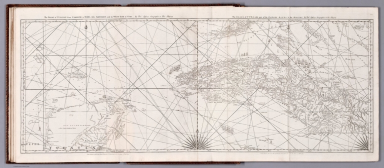
Author
[Cook, James, active 1762-1775, Jefferys, Thomas]
Full Title
The coast of Yucatan from Campeche to Bahia del Ascension; with the west end of Cuba. By Thos. Jeffreys, Geographer to His Majesty. -- The Island of Cuba with part of Bahama Banks & the Martyrs. By Thos. Jeffreys, Geographer to His Majesty. London. Printed for Robt. Sayer, Map & Printseller, No. 53 in Fleet Street, as the Act directs 20th Feby. 1775.
List No
14471.046
Note
Nautical chart of the coast of Yucatan from Campeche Bay to Bahía de la Ascensión, as well as Cuba, in 1775. Shows cities, topography, vegetation, bodies of water, drainage, coastlines, ports, bays, anchorage, shoals, islands, rocks and depths, given in fathoms. Relief shown pictorially and with hachures. Includes rhumb lines, latitudinal and longitudinal lines, as well as compass roses with north oriented toward top of sheet. With descriptive notes throughout. Black and white copper-engraving. Chart is 45 x 120 cm, on fold-out plate 55 x 127 cm. Chart appears in second volume of atlas.
Author
Jefferys, Thomas
Full Title
The coast of Yucatan from Campeche to Bahia del Ascension; with the west end of Cuba. By Thos. Jefferys, Geographer to His Majesty. London, printed for Robt. Sayer, Map & Printseller, no. 53 Fleet Street, as the Act directs 20th. Feby. 1775.
List No
4723.012
Note
Engraved nautical chart showing tracks, rhumb lines, currents, etc. Relief shown pictorially; depths by soundings and isoline. Sheet CF.6 of "... a complete chart of the West Indies ..."
Author
Jefferys, Thomas
Full Title
The Island of Cuba with part of the Bahama Banks & the Martyrs. By Thos. Jefferys, Geographer to his Majesty. London, printed for Robt. Sayer, Map & Printseller, no. 53 in Fleet Street, as the Act directs 20 Feby. 1775.
List No
4723.013
Note
Engraved nautical chart showing tracks, rhumb lines, currents, etc. Relief shown pictorially; depths by soundings. Covers also the southern Florida Keys and Dry Tortugas. Sheet CG.7 of "... a complete chart of the West Indies ..."
Author
Jefferys, Thomas
Full Title
The Windward Passage, with the several passages, from the east end of Cuba, and the north part of St. Domingo. By Thos. Jefferys, Geographer to his Majesty. London, printed for Robt. Sayer, Map & Printseller, no. 53 Fleet Street, as the Act directs 20th Feby. 1775.
List No
4723.014
Note
Engraved nautical chart showing tracks, rhumb lines, etc. Relief shown pictorially; depths by soundings. Includes geographic notes. Covers also part of the Bahamas and the Turks and Caicos Islands. Sheet CH.8 of "... a complete chart of the West Indies ..."
Author
[Orta, Bernardo de, Dirección de Hidrografía]
Full Title
Plano del Puerto de Veracruz en la Costa Ocidental del Seno Mexicano. Por Dn. Bernardo De Orta, Capitan de Navio Graduado de la Rl. Armada y de dicho Puerto. Año de 1798.
List No
10488.000
Author
[Malte-Brun, Conrad, 1775-1826, Lapie, Pierre]
Full Title
Etats Unis et Grandes Antilles.
List No
2631.076
Note
Prime meridian is Paris.
Author
[Carey, H. C., Lea, I.]
Full Title
Geographical, Historical, And Statistical Map Of Cuba And The Bahama Islands. Cuba and the Bahama Islands. No. 40. B. Tanner Sc.
List No
0122.035
Note
In full color surrounded by text.
1-10 of 10
|