|
REFINE
Search Results: All Fields similar to 'New and Britain and Island and Papua and New and Guinea'
1-10 of 10
Author
[Carteret, Philip, d. 1796, Hawkesworth, John, 1715?-1773]
Full Title
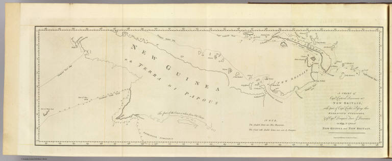
A chart of Captn. Carteret's discoveries at New Britain, with part of Captn. Cooke's passage thro Endeavor Streights, & of Captn. Dampier's tract & discoveries in 1699, & 1700, at New Guinea and New Britain. Engraved by W. Whitchurch, Pleasant Row, Islington. (London: printed for W. Strahan; and T. Cadell in the Strand, MDCCLXXIII).
List No
3403.016
Note
Engraved nautical chart showing coastal features only. Depths shown by soundings.
Author
Dalrymple, Alexander
Full Title
Plan of the Islands of Aiou or Yowl by Capt. Thomas Forrest
List No
16141.149
Author
Dalrymple, Alexander
Full Title
Plan of Carterets Harbour in St. Georges Sound New Britain 1767
List No
16141.153
Note
Note that this area is not New Britain but in fact on the western side of New Ireland, facing to the west St. George's Channel with New Britain on the other side.
Author
Dalrymple, Alexander
Full Title
Plan of English Cove and Gower's Harbour in New Britain 1767.
List No
16141.154
Author
Dalrymple, Alexander
Full Title
Plan of Port Praslin...1769
List No
16141.155
Author
Dalrymple, Alexander
Full Title
Plan of Mackrel Bay and Water Bay on the So. Coast of New Guinea (with) Port Montague on New Britain (with) Plan of the Bay Choiseuil
List No
16141.160
Author
Industrial Services Division, Bureau of Public Relations, War Department
Full Title
Newsmap : Monday, December 27, 1943. Week of December 16 to December 22, 224th week of the War - 106th week of U. S. participation. Volume II No. 36. Distributed by Industrial Services Division, Bureau of Public Relations, War Department. Prepared from public sources of information. U. S. Government Printing Office: 1943.
List No
14150.000
Note
Three lithographed maps, in black, brown and white. Maps show political boundaries, rivers, railways, trails, and locations of Soviet and German military attacks. Geography selected to depict military events of World War II, from December 16 to 22, 1943. Maps: (East Indies) (29 x 113 cm, scale 1:5,000,000) -- Eastern Front (42 x 27 cm, scale 1:5,000,000) -- Southwest New Britain (17 x 26 cm, scale 1:1,000,000). Each map includes a bar scale; latter two include legends. Accompanying historical notes describe the war fronts: USSR -- Southwest Pacific -- Italy -- Air offensive -- Yugoslavia. Features photographs. Sheet 89 x 120 cm, folded to 31 x 23 cm. Stamp on verso: Received Dec 29 1943 C. E. King.
Author
News Map of the Week, Inc.
Full Title
World News of the Week : Monday, Jan. 3, 1944. Covering period Dec. 24 to Dec. 30. Volume 6, No. 18. Published and copyrighted (weekly), 1944, by News Map of the Week, Inc., 1512 Orleans Street, Chicago, Illinois. Published in two sections : Section one. Lithographed in U. S. A.
List No
14152.000
Note
Lithographed world map, in color. Shows political boundaries and military events of World War II, from December 24 to 30, 1943. Relief illustrated with hachures. Descriptive text throughout, e.g.: Nazis lose three destroyers, other ships in Bay of Biscay. Map indexed according to historical notes beneath map. Features photographs, illustrations, and international time zones. With two inset maps: How New Britain compares in size with Massachusetts -- Scharnhorst. Also, with two diagrams: Total railroad mileage -- Saving the wounded. Map is 56 x 115 cm, on sheet 89 x 120 cm, folded to 31 x 23 cm.
Author
Industrial Services Division, Bureau of Public Relations, War Department
Full Title
Newsmap : Monday, January 10, 1944. Week of December 29 to January 5, 1944, 226th week of the War - 108th week of U. S. participation. Volume II No. 38. Distributed by Industrial Services Division, Bureau of Public Relations, War Department. Prepared from public sources of information. U. S. Government Printing Office: 1944.
List No
14157.000
Note
Five lithographed maps, in black, blue and white. Maps show political boundaries, rivers, and railways. Geography selected to depict military events of World War II, from December 29 to January 5, 1944. Maps: (New Britain I.) (26 x 71 cm, scale 1:1,750,000) -- (Italy) (43 x 43 cm, scale 1:750,000) -- (Cassino) (17 x 27 cm, scale 1:175,000) -- (Chieti) (23 x 27 cm, scale 1:175,000) -- (Border between Poland and Russia) (23 x 27 cm, scale 1:1,000,000). Each map includes a bar scale. Accompanying historical notes describe the war fronts: USSR -- Southwest Pacific -- Italy -- Air offensive. Features photographs. Sheet 89 x 120 cm, folded to 31 x 23 cm. Stamp on verso: Received Jan 12 1943 C. E. King.
Author
News Map of the Week, Inc.
Full Title
World News of the Week : Monday, Feb. 21, 1944. Covering period Feb. 11 to Feb. 17. Volume 6, No. 25. Published and copyrighted (weekly), 1944, by News Map of the Week, Inc., 1512 Orleans Street, Chicago, Illinois. Published in two sections : Section one. Lithographed in U. S. A.
List No
14160.000
Note
Lithographed world map, in color. Shows political boundaries and military events of World War II, from February 11 to 17, 1944. Relief illustrated with hachures. Descriptive text throughout, e.g.: Reds close in on trapped Nazis. Map indexed according to historical notes beneath map. Features photographs, illustrations, and international time zones. With inset map: (New Guinea, including New Britain Island). Map is 56 x 115 cm, on sheet 89 x 120 cm, folded to 31 x 23 cm.
1-10 of 10
|