
|
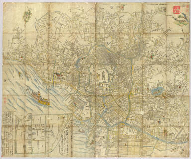 View larger, zoomable image (turn off pop-up blocker) Full Title: Zoho Edo oezu : saru sangatsu aratame gomon eiri. Enpo 8 [1680] Author: Hayashi, Yoshinaga Date: 1680 This map of Edo (Tokyo) differs hugely from the present day metropolis, with the exception of the area in the center of the map around the Imperial Palace, which has remained largely unchanged for over 300 years. Many properties are identified and cultural features such as temples are delineated pictorially.This historical cartographic image is part of the Japanese Map Collection of the UC Berkeley East Asian Library www.davidrumsey.com/japan, a large collection of online historical maps, atlases and other cartographic items. Read more about the Collection. Or you can view the entire Japanese Map Collection in LUNA Browser.
Full Japanese Historical Map Collection Catalog Record: Author: Hayashi, Yoshinaga Date: 1680 Short Title: Zoho Edo oezu. Publisher: [Kyoto] : Hayashi-shi Yoshinaga Type: Pocket Map Obj Height cm: 123 Obj Width cm: 150 Scale 1: None shown Note: Oriented with north to the right. Wood block print. Hand col. In Japanese. Shows land tenures of daimyo with crests. Shows temples and shrines pictorially. Title from Edo zu somokuroku /Iwata Hoju.p.14. Includes inset and legend. Folded in cover 26 x 19 cm. East Asian Library call number: Ea6. Country: Japan State/Province: Tokyo (Japan : Fu) City: Tokyo (Japan) Full Title: Zoho Edo oezu : saru sangatsu aratame gomon eiri. Enpo 8 [1680] List No: Ea6 Series No: 2 Published In: Zoho Edo oezu : saru sangatsu aratame gomon eiri. Enpo 8 [1680] Publication Author: Hayashi, Yoshinaga Publication Date: 1680 Publication List No: Ea6 Publication Type: Pocket Map Publication Maps: 1 Publication Height cm: 26 Publication Width cm: 19 Image No: Ea6
Important!
home
| about | view the collection | help |