 |
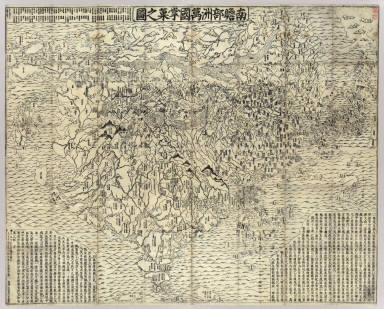
 View larger, zoomable image (turn off pop-up blocker) Full Title: Nanzenbushu bankoku shoka no zu / Rokashi. Hoei 7 [1710] Author: Hotan, 1654-1738 Date: 1710 This map is based on a Buddhist conceptual view of the world with India at the center, yet it includes contempory European geographical knowledge - Europe is shown as a group of islands in the upper left corner and South America is is an island in the ocean south of Japan on the right side. The map has many placenames in Asia not found on European maps of the period. In the center of the map in the Himalayan mountains is a quadruple helix symbolizing the origins of the four great rivers of the region (the Indus, the Ganges, the Brahmaputra and the Sutlej rivers) emanating from the heads of a horse, a lion, an elephant, and an ox. This is the site of the present day Lake Manasarovar, the highest fresh water lake in the world.This historical cartographic image is part of the Japanese Map Collection of the UC Berkeley East Asian Library www.davidrumsey.com/japan, a large collection of online historical maps, atlases and other cartographic items. Read more about the Collection. Or you can view the entire Japanese Map Collection in LUNA Browser.
Full Japanese Historical Map Collection Catalog Record: Author: Hotan, 1654-1738 Date: 1710 Short Title: Nanzenbushu bankoku shoka no zu Publisher: Keicho [Kyoto] : Bundaiken Uje Type: Case Map Obj Height cm: 115 Obj Width cm: 145 Scale 1: None shown Note: Wood block print. In Japanese. Shows the world based on Buddhist literature from India and China. Bibliography. Title in Nihon kohan chizu shusei: Nanzenbushu bankoku shoka no zu. Folded to 36 x 20 cm. East Asian Library call number: A1. World Area: World/Asia Full Title: Nanzenbushu bankoku shoka no zu / Rokashi. Hoei 7 [1710] List No: Ea6 Series No: 2 Published In: Nanzenbushu bankoku shoka no zu / Rokashi. Hoei 7 [1710] Publication Author: Hotan, 1654-1738 Publication Date: 1710 Publication List No: A1 Publication Type: Case Map Publication Maps: 1 Publication Height cm: 36 Publication Width cm: 20 Image No: A1
Important!
home
| about | view the collection | help |