COLLECTION NAME:
David Rumsey Historical Map Collection
Record
Author:
Dey, J. Ogden
Author:
Vance, David H.
Date:
1825
Short Title:
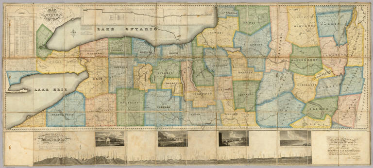
Map of the Western Part of the State Of New York.
Publisher:
John Ogden Dey
Publisher Location:
Albany
Type:
Case Map
Obj Height cm:
82
Obj Width cm:
186
Scale 1:
330,000
Note:
Vance published the upper and western part of this map in 1823 (see Streeter 3818). Dey enlarged it in 1824 and 1825 by adding an eastern portion, taking the state to its eastern boundary with New England, and also adding a lower section that includes a "Geological Profile Extending from the Atlantic to Lake Erie" (which shows the Erie Canal) and four views of the complete Erie Canal. On the main map is a profile of the western and middle sections of the Erie Canal and tables of statistics and geological remarks. The whole production is a celebration of the recently completed Erie Canal. Streeter calls the 1823 issue a "fine large scale colored map." Full color by county. Map has silk edging and is dissected into 36 sections. Folds with marbled paper end sheets, and lies loosely in quarter leather marbled paper covered boards 30x17 with leather ties; "Dey's Improved Map Of N. York" is stamped in gilt on the spine. Scarce.
Reference:
P-Maps 509; cf Streeter 3818.
State/Province:
New York
Full Title:
Map of the Western Part of the State Of New York. 1823. By D.H. Vance. Improved and enlarged to the east boundary of the State by J. Ogden Dey 1824. Engraved by Balch, Rawdon & Co. To His Excellency De Witt Clinton ... And ... Stephen Van Rensselaer ... This Map is Inscribed with their permission. By The Publisher John Ogden Dey. Albany January 1825. Copy Right Secured. (with four inset profiles).
List No:
4999.001
Series No:
2
Engraver or Printer:
Balch, Rawdon & Co.
Publication Author:
Dey, J. Ogden
Publication Author:
Vance, David H.
Pub Date:
1825
Pub Title:
Map of the Western Part of the State Of New York. 1823. By D.H. Vance. Improved and enlarged to the east boundary of the State by J. Ogden Dey 1824. Engraved by Balch, Rawdon & Co. To His Excellency De Witt Clinton ... And ... Stephen Van Rensselaer ... This Map is Inscribed with their permission. By The Publisher John Ogden Dey. Albany January 1825. Copy Right Secured. (with four inset profiles).
Pub Reference:
P-Maps 509; cf Streeter 3818
Pub Note:
See note field above.
Pub List No:
4999.000
Pub Type:
Case Map
Pub Maps:
1
Pub Height cm:
30
Pub Width cm:
17
Image No:
4999001
Authors:
Dey, J. Ogden; Vance, David H.
Collection:
Rumsey Collection