COLLECTION NAME:
David Rumsey Historical Map Collection
Record
Author:
Beck, Lewis C.
Date:
1823
Short Title:
Plan of St. Louis.
Publisher:
Charles R. and George Webster
Publisher Location:
Albany
Type:
Book Map
Obj Height cm:
18
Obj Width cm:
43
Scale 1:
None shown
Note:
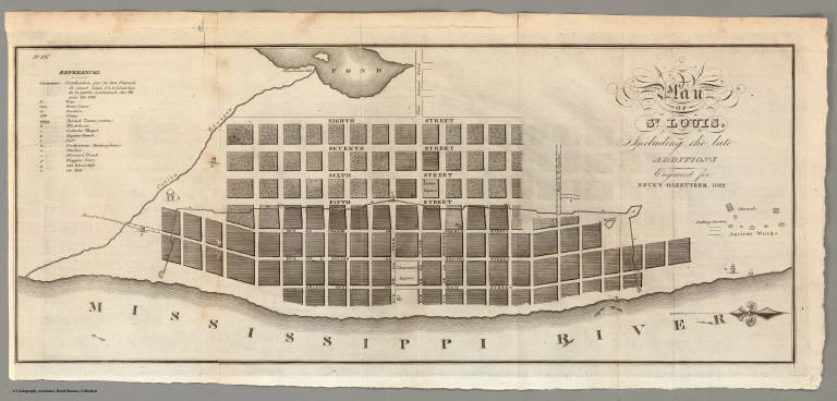
Map without color. "Ancient works" including a falling garden and mounds are shown at the right. Other items noted include churches, ports, the jail, the market and the fortification that snakes through the city.
Reference:
Howes B297 ("b"); Buck 180; Graff 224; Sabin 4231; Streeter 1438; P-Maps p327; Karrow 4-1415.
State/Province:
Missouri
City:
Saint Louis (Mo.)
Full Title:
Plan of St. Louis, Including the late Additions. Engraved for Beck's Gazetteer 1822.
List No:
4071.002
Series No:
3
Publication Author:
Beck, Lewis C.
Pub Date:
1823
Pub Title:
A Gazetteer of The States of Illinois and Missouri ... With A Map, and Other Engravings. By Lewis C. Beck, A.M. ... Albany: Printed by Charles R. and George Webster ... 1823. (with) Map of the States of Illinois & Missouri by Lewis C. Beck A.M.
Pub Reference:
Howes B297 ("b"); Buck 180; Graff 224; Sabin 4231; Streeter 1438; P-Maps p327; Karrow 4-1415.
Pub Note:
Howes: "One of the earliest American books describing in detail the Illinois settlement and the adjacent country west of the Mississippi." Streeter: "...an important book. Beck gives the first full length account of Illinois and Missouri, and the map, on the fairly large scale of 24 miles to the inch, is the first map of either state on such a large scale." In the Geographical Memoir to his New American Atlas, Henry Tanner lists Beck's map as a source for his Map of the States of Illinois and Missouri: "This is a very accurate map, from which I obtained most of the county divisions in the latter state."
Pub List No:
4071.000
Pub Type:
Gazetteer Book
Pub Maps:
2
Pub Height cm:
23
Pub Width cm:
15
Image No:
4071002
Authors:
Beck, Lewis C.
Collection:
Rumsey Collection