COLLECTION NAME:
David Rumsey Historical Map Collection
Record
Author:
Burr, David H., 1803-1875
Date:
1839
Short Title:
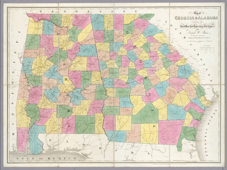
Map of Georgia & Alabama.
Publisher:
John Arrowsmith
Publisher Location:
London
Type:
Atlas Map
Obj Height cm:
92
Obj Width cm:
123
Scale 1:
633,600
Note:
In full color by county. Postal routes by coach, stage, sulkey, cross, rail roads and canals shown. In 8 sections mounted on linen. Label on back states "No. 7. Georgia, Alabama."
Reference:
Phillips 4525-7,1379a-7.
State/Province:
Alabama
State/Province:
Georgia
Subject:
Postal
Full Title:
Map of Georgia & Alabama Exhibiting the Post Offices, Post Roads, Canals, Rail Roads, &c. By David H. Burr. (Late Topographer to the Post Office.) Geographer to the House of Representatives of the U.S. John Arrowsmith. Entered ... July 10th, 1839, by David H. Burr ... District of Columbia.
List No:
0104.007
Series No:
8
Publication Author:
Burr, David H., 1803-1875
Pub Date:
1839
Pub Title:
(The American Atlas).
Pub Reference:
Phillips 4525,1379a note; Streeter 3859; Wheat 441; Sabin 9438 (with lithographic views).
Pub Note:
13 separate sheets dissected & mounted on linen. 12 of the maps are of the states, all on the same scale of 10 miles to 1 inch, with the 13th map of the entire United States from coast to coast, a map that Wheat called "in every respect a towering example especially in the Far West, and it is strange that it should be so rare!" Wheat notes that Burr used Jedediah Smith's original map as a source and was "the nearest thing to Jedediah Smith's map that had been published" at that time. The likely date of this copy is 1842 based on the Maine boundary, the additional counties colored in in Michigan, and the general progression of the railroads; however, there have been no changes in the plate since 1839, only changes in the coloring of counties, railroads and boundary lines to indicate a later date. The 1846 boundary of Oregon and Canada is almost certainly a later addition, because the ink is a darker red than the other reds on the map. This set was published as a stack of 13 mounted and folded sheets, without a title page or binding. The U.S. map places the Owyhee River on the Malheur River - is this a misreading of the Smith material, or a correct reading of Smith's mistake because Fremont had correctly identified both rivers. Most of the examples are dissected in quarters; these are dissected in eighths. This "atlas" is one of the great rarities of American 19th century cartography, with complete sets being almost impossible to find. John Arrowsmith engraved the plates in London, an unusual collaboration at this late a date between an American cartographer and a London engraver. The 13 sheets are folded and nestled into a modern beige canvas covered box 53x37 which opens like a book, with title on the spine reading "The American Atlas. David H. Burr. 1839." Maps have full hand painted color.
Pub List No:
0104.000
Pub Type:
National Atlas
Pub Maps:
13
Pub Height cm:
94
Pub Width cm:
124
Image No:
0104007
Authors:
Burr, David H., 1803-1875
Collection:
Rumsey Collection
