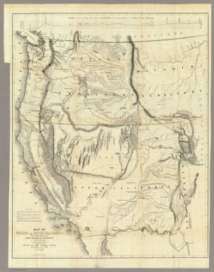
Detail View: David Rumsey Historical Map Collection: Map Of Oregon And Upper California.
|
Author:
|
Fremont, J.C.
|
|
Date:
|
1848
|
|
Short Title:
|
Map Of Oregon And Upper California.
|
|
Publisher:
|
Wendell and Van Benthuysen
|
|
Publisher Location:
|
Washington
|
|
Type:
|
Book Map
|
|
Obj Height cm:
|
85
|
|
Obj Width cm:
|
68
|
|
Scale 1:
|
3,000,000
|
|
Note:
|
The map for the first time filled in the details of the Great Basin. Charles Preuss drew the map. A smaller version of the map appears in President Polk's Message of 1849 (see our copy). Report rebound with cloth covered boards and title on spine.
|
|
Reference:
|
WC 150; Wheat 559.
|
|
State/Province:
|
California
|
|
State/Province:
|
Oregon
|
|
Full Title:
|
Map Of Oregon And Upper California From the Surveys of John Charles Fremont And other Authorities. Drawn By Charles Preuss Under the Order of the Senate Of The United States, Washington City 1848. Lithy. by E. Weber & Co. Balto. (inset) Profile of the travelling route from the South Pass of the Rocky Mountains to the Bay of San Francisco.
|
|
List No:
|
1857.001
|
|
Series No:
|
2
|
|
Engraver or Printer:
|
Preuss, Charles
|
|
Publication Author:
|
Fremont, J.C.
|
|
Pub Date:
|
1848
|
|
Pub Title:
|
Geographical Memoir upon Upper California In Illustration of His Map of Oregon and California, by John Charles Fremont: Addressed to the Senate of the United States. Washington: Wendell and Van Benthuysen, Printers. 1848. [Senate.] 30th Congress, 1st Session. Miscellaneous. No. 148.
|
|
Pub Reference:
|
WC 150; Wheat 559.
|
|
Pub Note:
|
See note field above.
|
|
Pub List No:
|
1857.000
|
|
Pub Type:
|
Exploration Book
|
|
Pub Maps:
|
1
|
|
Pub Height cm:
|
85
|
|
Pub Width cm:
|
68
|
|
Image No:
|
1857001
|
|
Download 1:
|
|
|
Download 2:
|
|
|
Authors:
|
Fremont, J.C.
|
|
Collection:
|
Rumsey Collection
|