COLLECTION NAME:
David Rumsey Historical Map Collection
Record
Author:
Farwell, Willard B.
Date:
1885
Short Title:
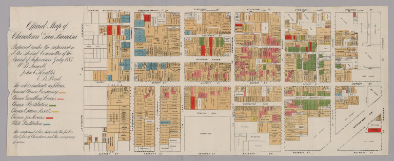
Official Map of Chinatown in San Francisco.
Publisher:
A.L. Bancroft
Publisher Location:
San Francisco
Type:
Separate Map
Obj Height cm:
22
Obj Width cm:
54
Note:
Map details the various districts: Chinese occupancy, gambling, prostitution, opium resorts, joss houses (temples or shrines), and white prostitution. Map also describes use of the ground floor for each parcel. This map is a part of the volume: The Chinese at Home and Abroad: Together with the Report of the Special Committee of the Board of Supervisors of San Francisco on the Condition of the Chinese Quarter of that City. Covers area between Kearny Street and Stockton Street, and California Street and Broadway Street. Property of San Francisco Public Library; location: Encap Drawer 1885. Encapsulated in mylar. Color.
Reference:
Link to full text of the 1885 San Francisco Municipal Report on the "Condition of the Chinese Quarter and the Chinese in San Francisco." This map appeared in the report at the end. The report is part two of Willard B. Farwell's "The Chinese at Home and Abroad." http://archive.org/…
County:
San Francisco
City:
San Francisco
Subject:
Land Use
Full Title:
Official Map of Chinatown in San Francisco.
List No:
5807.000
Series No:
1
Publication Author:
Farwell, Willard B.
Pub Date:
1885
Pub Title:
Official Map of Chinatown in San Francisco.
Pub Note:
See note field above.
Pub List No:
5807.000
Pub Type:
Separate Map
Pub Maps:
1
Pub Height cm:
22
Pub Width cm:
54
Image No:
5807000
Authors:
Farwell, Willard B.
Official Map of Chinatown in San Francisco.
